Morris & Fan. Reservoir Sedimentation Handbook
Подождите немного. Документ загружается.

SEDIMENT YIELD FROM WATERSHEDS 7.11
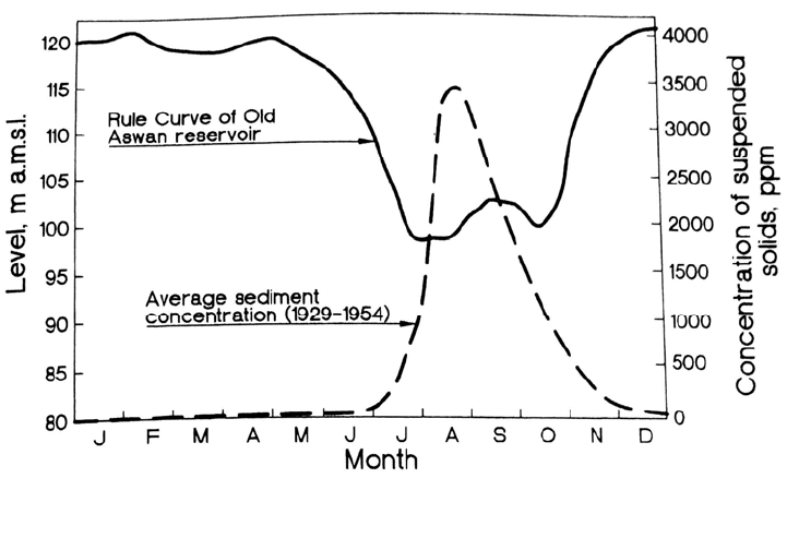
FIGURE 7.7 Seasonal variation in discharge and sediment concentration in Nile River at Aswan,
and the operating rule used at the Old Aswan Dam which minimized impounding and trapping o
f
the heavy sediment load (Shahin, 1993).
Slay
maker, 1994). However, from an engineering standpoint, a long-term change can be
any trend evident over a period of decades. Sediment yield is increased over time by
activities that reduce or destroy the vegetation cover, disturb the soil, or increase the peak
or total runoff. Sediment yield is decreased by the construction of upstream ponds and
reservoirs that trap sediment, protection of exposed erodible surfaces with either
vegetative or hard cover, and exhaustion of the supply of erodible sediment. When
records are based on a short period that is unusually wet or dry or contains an
extraordinary flood, the period-of-record sediment yield may depart significantly from
the true long-term conditions, giving the false appearance of a trend.
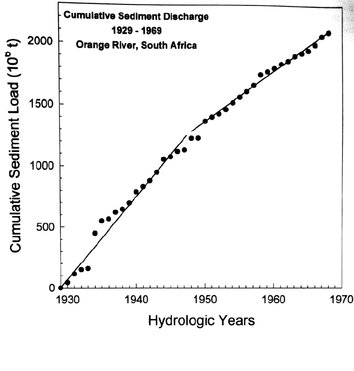
Using the graph in Fig. 7.8 of 40 years of suspended sediment data from the lower
Orange River in South Africa, which transports mostly fine sands and silts and has the
longest sediment record in that country, Rooseboom (1992) concluded that the declining
sediment yield in the Orange River probably reflected two processes: exhaustion of the
supply of readily erodible sediment and sediment trapping by farm ponds. Trends in
sediment yield may be best analyzed by constructing a double-mass diagram of the
cumulative liquid and solid discharge, which helps compensate for apparent changes in
load due to streamflow variability alone, as in Fig. 7.13.
Long-term changes in sediment yield accompany land use conversion, such as from
natural to commercially harvested forest, from forest to agriculture, or from agriculture to
urban use. Some of these conversions may be reversible, such as the conversion of forest
land to agricultural use and subsequent recovery of the forest following abandonment of
farms. The downstream sediment yield due to cycles of disturbance and recovery will be
modified by the temporary storage of eroded sediment. As described by Trimble (1977),
farmland in the southeastern United States experienced soil loss on the order of 1 mm/yr
over a period of more than 150 years, yet the export of sediment by rivers accounted for
less than 0.06 mm/yr because 94 percent of the eroded sediment was redeposited as
colluvium at the base of slopes, or as channel and alluvial floodplain deposits (as much as
6 m deep in some areas). Today streams are downcutting through these historical deposits
and exporting sediments eroded from farms during the previous century.
SEDIMENT YIELD FROM WATERSHEDS 7.12
FIGURE 7.8 Cumulative sediment discharge for Orange River, South Africa, showing a long-ter
m
decline in sediment yield, apparently due to the construction of upstream farm ponds plus
exhaustion of the readily erodible sediment supply because of soil loss (Rooseboom, 1992).
Similar phenomena were reported by Sutherland and Bryan (1988) in a detailed
sediment budget analysis of a small (0.30-km
2
) semiarid basin in Kenya, in the watershed
tributary to Lake Baringo. Land misuse and overgrazing since the 1930s led to severe soil
erosion and degradation in the region; bedrock and parent material were exposed on
slopes and much of the material eroded from slopes accumulated as temporary colluvial
deposits at the base of the slopes. After rapid erosion from hillslopes was no longer
possible because of topsoil exhaustion, the colluvial deposits constituted the primary
source of sediment discharged to the stream channel system. Monitoring of sediment
production and deposition using 441 erosion pins, Gerlach troughs, and repeated cross-
section surveys of stream channels, revealed that colluvial deposits were exporting
sediment to stream channels at a rate of 7030 t/km
2
/yr, as compared to only 922 t/km
2
/yr
for denuded primary source areas. The fine-grained sediments eroded from the colluvium
were efficiently delivered to the channel system and exported, and 96 percent of the
sediment exported from the basin was in the form of suspended load. It was estimated
that this erosion would remove 83 percent of the colluvial sediment reservoir over a
period of 43 years.
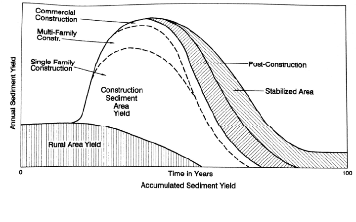
Sediment yield from urbanizing areas will proceed through a cycle as land use
progresses from: (1) low-yield pre-development land uses to (2) high-yield construction
SEDIMENT YIELD FROM WATERSHEDS 7.13
FIGURE 7.9 Schematic sequence in the change in sediment yield with time due to the urbanizatio
n
of a rural watershed (Livesey, 1975).
si
tes characterized by disturbed soil and a high efficiency storm drainage network, to (3)
protected soil cover (Fig. 7.9). Increased peak discharge from urban areas will also
increase long-term channel erosion downstream. When roads in urban areas are not
paved, sediment yield may be continuously high.
The reason for sediment yield trends can be obvious in smaller watersheds where
cause-effect relationships may be readily evident and in areas where natural sediment
yield variability is not extreme. However, in larger watersheds where multiple activities
occur simultaneously, in basins where a large percentage of the eroded sediment is stored
between the point of erosion and the basin exit, and when natural variation in sediment
yield is very high, the understanding and prediction of long-term trends can be
problematic. Day (1988) reported that one of the principal objectives of the Canadian
sediment monitoring program was to provide data for trend analysis to better understand
the impacts of upstream land use change and water resource construction activities.
However, success was limited by problems including less-than-ideal station locations,
major flow diversions within basins, the difficulty of discerning between natural and
human-influenced changes, and the paucity of data on land use activities across large
basins. Generally, as basin size increases, the data on land use become increasingly
sparse. However, as basin size decreases the sediment yield becomes increasingly
variable, making it difficult to distinguish between human-induced and natural causes.
Only the downstream effects of sediment trapping by reservoirs was clearly noticeable.
When published land use data are available, the land use classification may say little
about actual erosion conditions in a watershed as a result of activities such as logging,
grazing, and fuelwood harvest, as suggested by the highly degraded "forest" area shown
in Fig. 7.10. Extreme variability in sediment yield in semiarid climates can frustrate
studies even in small watersheds, where the cause-effect relationship between land use
change and sediment yield would be expected to be clearly evident.
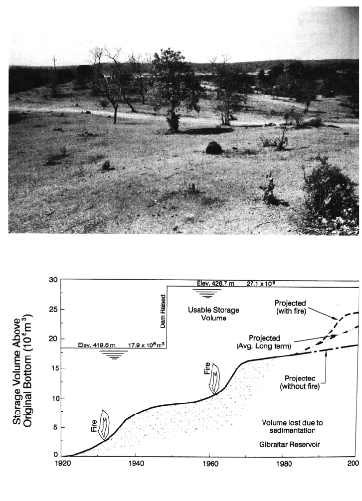
Multiyear departures from long-term conditions can also result from disturbances
such as fire. The effect of fire on the sediment yield from the highly erodible soils in the
brush-dominated watershed tributary to Gibraltar reservoir at Santa Barbara, California,
is illustrated in Fig. 7.11. However, fire does not necessarily increase sediment yield.
Mohrman and Ewing (1991) examined changes in suspended sediment load following the
SEDIMENT YIELD FROM WATERSHEDS 7.14
FIGURE 7.11 Effect of fire on sediment yield, as exemplified by the drainage area tributary to
Gibraltar Reservoir, Santa Barbara, California (modified from City of Santa Barbara, 1987).
FIGURE 7.10 Area called as “forest” in Andhr
a Pradesh, India, but devastated by overgrazing,
fuelwood harvesting, etc. (G. Morris).
l
arge forest fires in Yellowstone National Park during 1988. From a comparison of data
during 1985-86 and 1988-89 for gages on Yellowstone River at Corwin Springs (4140
km
2
) and Lamar River at Tower Junction (1690 km
2
), with 30 percent and 38 percent of
the total watershed burned respectively, they concluded that the fires produced no major
changes in sediment loading. The largest sediment load in the 4-year record examined
was in a prefire year.
SEDIMENT YIELD FROM WATERSHEDS 7.15
7.2.6 Changes in Long-Term Yield Due to Geomorphic Factors
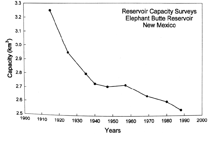
Long-term changes in sediment yield are exemplified by the case of Elephant Butte
reservoir on the Rio Grande in New Mexico. Constructed in 1915, this 3250-Mm
3
reservoir lost capacity at an annual rate of 30 Mm
3
during the first 5 years after
construction, but the rate of storage loss declined, and since 1940 storage loss has
averaged 4 Mm
3
per year (Fig. 7.12). This period has also seen a large reduction in
sediment yield from Rio Puerco, a major sediment contributor, attributed to factors
including changes in river channel morphology. The reservoir was constructed toward the
end of a period of river channel incision. Upstream reservoirs also reduced the
unregulated tributary area (Orvis, 1989). The effect of long-term geomorphic factors is
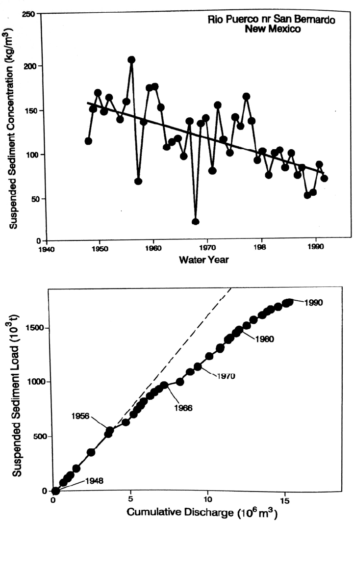
suggested in the Rio Puerto data (Fig. 7.13), which illustrates the clear trend of
decreasing suspended sediment concentration. Sediment load at this gage station has not
been affected by upstream reservoir construction.
Sediment yield has declined since 1940 across the Colorado basin as a result of
geomorphic processes. Arroyos within the basin incised rapidly and produced large
amounts of sediment during the late nineteenth and early twentieth centuries. For
example, Chaco River in northwestern New Mexico was 2.4 m wide and 0.5 m deep in
1849, but by 1925 had enlarged to 46 to 137 m in width and 6 to 9 m in depth. The reason
for the onset of the entrenchment process, with attendant high rate of sediment production
due to channel erosion and subsequent reduction in sediment yield, is not well-
understood.
Different researchers have attributed changing channel erosion patterns to increased
grazing pressure in the late nineteenth century, changes in suspended measurement
techniques in the Colorado River in the 1940s, climate variations including periods of
drought and of intense storms, erosion control activities in the watershed including
construction of reservoirs and stock ponds, and geomorphic factors. These factors were
summarized by Gellis et al. (1991), who concluded that all of the mentioned factors
contributed to the process with the exception of changes in measurement techniques,
FIGURE 7.12 Long-term storage loss in Elephant Butte Reservoir, Rio Grande River, United
States (Gorbach, 1996)
SEDIMENT YIELD FROM WATERSHEDS 7.16
FIGURE 7.13 Sediment concentration and double mass curve of annual suspended sediment
load runoff, Rio Puerco near An Bernardo, just upstream of confluence with Rio Grande (after
Gellis, 1991)
SEDIMENT YIELD FROM WATERSHEDS 7.17
since the limited available data suggest that the present sampling instruments would tend
to increase rather than decrease the apparent yield. It was concluded that the overall
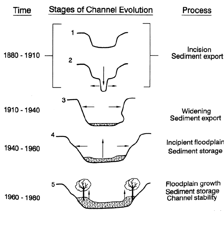
process could be interpreted within the context of a five-stage geomorphic model (Fig.
7.14). In this model, a period of incision (stage 1) is initiated within a basin by a
combination of factors, such as drought and increased grazing pressure, which
significantly reduce vegetative cover and initiate channel erosion. Subsequently channels
incise and enlarge through the gullying process (stage 2) until channel width expands and
slope diminishes, to the point that sediments can no longer be eroded. Vegetation then
invades the widened channel bottom, increasing hydraulic resistance and decreasing flow
velocity, which in turn further encourages sediment deposition and refilling the arroyo. A
new disturbance can reinitiate the incision process. Similar processes have been observed
in humid climates, where they tend to be accelerated in time. The five- stage model
represents a long-term cyclic process which occurs over a period of decades and which
can have a profound effect on sediment yields. Depending on its location on the long-
term cycle, sediment yield data from any particular time period may not necessarily
reflect the long-term condition.
FIGURE 7.14 Five-stage geomorphic process hypothesized to affect long-term cycles of strea
m
incision in a semiarid climate (adapted from Gellis et al., 1991).

SEDIMENT YIELD FROM WATERSHEDS 7.18
7.3 STRATEGIES FOR MEASURING SEDIMENT YIELD
Sediment yield can be computed from reservoir surveys or a fluvial sediment monitoring
program. Although both methods have potentially important sources of error, reservoir
survey data generally represent a more reliable measure of the long-term basin sediment
yield. However, reservoir surveys cannot provide data on the short-term variations in
sediment delivery, essential information for certain sediment management strategies.
Ideally both types of data will be available and can be checked against each other.
7.3.1 Reservoir Resurvey
Continuously impounding reservoirs act as excellent sediment traps, and successive
reservoir surveys can be compared to determine the sediment volume accumulated during
the survey interval. By correcting for trap efficiency, and converting the volume of
sediment deposits into sediment mass on the basis of dry bulk density, the total sediment
yield from the watershed can be computed. Reservoir survey procedures are described in
Chap. 10.
The thickness of sediment deposition is normally determined by repeated bathymetric
surveys and must also include areas above the normal pool elevation when deposition
occurs in the backwater zone. In reservoirs lacking reliable pre-impoundment
topographic data,
137
cesium sampling may be performed in continuously depositional
zones of fine sediment accumulation in reservoirs which began impounding several years
prior to atmospheric testing in the late 1950s.
Reservoir resurveys offer several important advantages:
1. The method does not rely on a continuous monitoring program, and as long as there is
accurate information on the pre-impoundment topography or data from a prior survey,
the next resurvey can be made at any time.
2. Measurement during peak flood discharge is not required.
3. Reservoir resurveys are typically much less costly than continuous fluvial sediment
monitoring stations. However, the subsoil borings needed to verify deposit unit
weights may be costly.
4. Bathymetric surveys can be performed to a high degree of accuracy.
5. The total load, including bed load, is measured.
Several sources of error and limitations are associated with the use of resurvey data to
estimate sediment yield, in addition to the geometric errors that can be associated with
bathymetric mapping and the difficulty of replicating the original cross-section locations.
1. The most prevalent source of error is the lack of accurate data on sediment unit
weight, which is usually estimated rather than sampled. Significant sediment
compaction of fine sediment may occur over time, causing unit weights to change
from one survey to the next. This is a particular problem associated with surveys early
in the reservoir life. Sediment compaction can cause the rate of storage loss to be
more rapid during the initial years of impounding as compared to later years, even
though the sediment load is constant.
2. In reservoirs with low rates of sediment accumulation, or for short intersurvey periods
which produce small sediment accumulation depths, the errors in bathymetric
mapping may be relatively large in relation to the intersurvey sediment thickness,
making it difficult to determine the volume of sediment accumulation. As a practical
matter, reservoir resurvey can normally determine the average sediment yield over a
period of several years. However, use of precise techniques in reservoirs with
SEDIMENT YIELD FROM WATERSHEDS 7.19
significant sediment loads can reduce the resurvey period to as little as 1 year, as
described in the Cachi case study.
3. Trap efficiencies approaching 100 percent will occur in reservoirs having a large
capacity:inflow ratio and high-level outlets, but it may be difficult to estimate the trap
efficiency in reservoirs having a small capacity:inflow ratio and low-level outlets, as
may occur in mountain hydropower stations.
4. Reservoir resurvey data do not provide information on the variation in sediment yield
over short time periods, which can be important for many types of sediment
management activities.
5. Both sediment and water can be diverted into or out of the upstream watershed.
6. Sediment removal from the system due to instream mining, at sediment traps operated
upstream of the reservoir, or from within the reservoir itself, must be accounted for.
7. Organic sediments can accumulate because of primary production within the
reservoir.
8. Finally, the reservoir resurvey method can be used to estimate sediment yield only
where there is a preexisting reservoir.
Butcher et al. (1992) have provided a more detailed description of several potential
sources of error in reservoir surveys.
In lakes or reservoirs lacking original bathymetric data, or where such data are not
reliable, the depth of deposit can be determined by using identifiable and datable horizons
within the sediment. One such sediment horizon corresponds to the appearance of man-
made radioactive material resulting from atmospheric testing or, in some areas of Europe,
the Chernobyl reactor accident. The use of
137
cesium as a datable horizon is described by
Ritchie et al. (1973) and McHenry and Ritchie (1980). It is well-suited for use as a
horizon because it sorbs rapidly and tightly onto surface sediments which are
subsequently washed into the reservoir. Reservoir sediment cores are sectioned and
radioactive emissions are counted, producing a profile of "'cesium activity as a function
of depth. The resulting profile is interpreted to determine the layer corresponding to the
large-scale atmospheric tests in the early 1960s, and sediment accumulation above this
horizon is measured. By analyzing a number of cores from different areas in the
impoundment, the overall depth of deposit may be determined. This method cannot be
used in areas where sediments have been reworked following deposition.
The total deposit depth can also be determined by using fully penetrating spud or core
samples, with the original bottom being detected by the change in grain size, color, and
compaction of the material. If a reservoir was affected by an extreme event, such as a
severe flood, an identifiable thick layer of coarser material may have been deposited
across much of the impoundment and can serve as an identifiable and datable horizon.
Similar layers might be caused by fire in the watershed, volcanic eruption, the initiation
or cessation of a major source of pollutants, etc.
Short-term studies of deposition can be performed by using sedimentation plates,
which are metal plates placed across the floor of the reservoir and measured the following
year to determine the depth of deposition over each plate. Relocation of plates following
burial in sediment may be aided using electronic positioning, a metal detector, or by
installing a visible wand near each plate. The plate technique is most suitable for
reservoirs that are drawn down annually so the plates can be set out and recovered on the
dry reservoir bed. Submerged sediment traps may also be used, but have the potential
disadvantage of causing localized interference with flow patterns that may affect
sediment trapping efficiency.
SEDIMENT YIELD FROM WATERSHEDS 7.20
7.3.2 Fluvial Monitoring
Fluvial sediment yield cannot be measured directly, but must be computed from stream
discharge and sediment concentration, both of which can vary over 3 orders of
magnitude. While the continuous monitoring of discharge typically presents little
difficulty, no method is available to continuously measure the discharge-weighted
suspended sediment concentration. Fluvial monitoring strategies attempt to work around
this limitation by using three principal types of data:
1. Depth-integrated discharge-weighted concentration data collected at discrete points in
time, giving particular emphasis to the monitoring of the larger discharge events
responsible for most sediment transport.
2. A larger number of single-point pumped samples collected at different times over the
hydrograph to better characterize both the rising and falling stage of significant runoff
events.
3. Continuous single-point samples of turbidity, which may or may not correlate well to
single-point suspended solids concentration, depending on the stream characteristics.
The bed load component is usually not measured but is estimated as a percentage of the
suspended sediment load or computed from stream hydraulics and bed load equations.
Dedkov and Moszherin (1992) analyzed fluvial sediment data from 1872 mountain rivers
worldwide, draining watersheds of 500 to 100,000 km
2
. Of these, bed load data were
available for only 158 rivers, or 8 percent of the stations. At these, the bed load
component averaged 23 percent of suspended sediment load. Because bed load
measurement was presumably neglected at stations where it was considered unimportant,
the average bed load transport at all stations was probably significantly less than 23
percent of the suspended load.
The sampled suspended sediment data may be used to compute the sediment load by
either of two strategies: extrapolation or interpolation. Extrapolation techniques make the
assumption that a relationship determined at one point in time, or over one range of
discharges, can be applied to another time period or to discharges greater than those
sampled. These assumptions are inherent in the utilization of C-Q relationships or
sediment rating curves, which are frequently determined from a few years of data and
then applied to a much longer discharge record to estimate long-term sediment yield, and
which are also frequently extrapolated to cover discharges larger than actually measured.
The sediment rating curve may be applied to either flow duration or time series discharge
data.
Interpolation makes the assumption that the suspended sediment concentration
measured at one point in time is representative of a longer time interval. Interpolation
procedures typically combine use of a time series of sediment concentration and
discharge values to compute load. The accuracy of this method is heavily dependent on
sampling frequency. A 10-min sampling frequency may be required for small flashy
streams, and a 24-h interval will produce large underestimates of sediment yield in all but
the largest rivers.
Both interpolation and extrapolation techniques have large potential sources of error.
Concentration-discharge relationships have a high degree of scatter: concentration can
vary by 3 orders of magnitude at a given discharge. This makes short-interval gaging and
interpolation of both discharge and sediment concentration the most accurate method
available. A monitoring station using this technique would use manual depth- integrated
sampling to calibrate the relationship between the discharge-weighted concentration and
the point concentration at the inlet to the pumped sampler and turbidity monitor. Both
stage and turbidity would be measured at short intervals, and pumped samples would be