Morris & Fan. Reservoir Sedimentation Handbook
Подождите немного. Документ загружается.

EROSION 6.27
sediment delivery ratio represents the fraction of the material eroded from a particular
site or watershed which reaches a downstream point where sediment yield is measured.
When the term is applied to an entire basin, it represents the ratio of gross erosion within
a watershed to the sediment yield during the same period. The delivery ratio may be
expressed in either decimal or percentage forms, and values may range from a few
percent to nearly 100 percent (Boyce, 1975) with larger delivery ratios generally applying
to smaller watersheds with steeper slopes and finer-grained material. Delivery ratios may
he computed for any desired time interval.
Determining the sediment delivery ratio is a critical step in converting estimates of
soil erosion within a basin into a quantifiable value of sediment yield. The problems
associated with estimating delivery ratio have been summarized by Walling (1983).
Sediment yield estimate can he highly sensitive to the sediment delivery ratio, as
illustrated by Walling (1994) using six watersheds in Nigeria, Mali, and Algeria. Erosion
rates from these watersheds ranged from 100 to 1500 t/km
2
/yr, whereas measured
sediment yield averaged 211 t/km
2
/yr with a maximum value of 483 t/km
2
/yr. The
sediment delivery ratio in these basins was about 10 percent, and a 1 percent error in
estimating the delivery ratio would have the same impact on the yield estimate as a 10
percent error in the erosion rate estimate.
6.11.2 Causes of Reduced Sediment Delivery
Sediments and associated pollutants mobilized by sheet and rill erosion may be
redeposited by a variety of mechanisms prior to reaching stream channels, where
transport processes are generally more efficient. Redeposition processes have been
summarized by Novotny et al. (1986):
1. Rainfall impact detaches soil particles and maintains them in suspension, but as
rainfall intensity declines the excess particles in suspension are deposited.
2. Overland flow detaches and transports particles. The sediment content of
overland flow is at or near the saturated state, and the sediment-carrying
capacity of overland flow is directly proportional to discharge. As flow is
reduced during the receding portion of the hydrograph, excess sediment is
deposited.
3. Vegetation retards flow and filters out particles during shallow flow conditions.
4. Infiltration reduces overland flow, causing sediment to he filtered out or
deposited.
5. Small depressions, ponding, and retardance by vegetation and litter reduce flow
velocity and cause sediment to be deposited.
6. Slope reduction at the base of hillslopes or near channels reduces flow velocity
and causes sediment to be deposited.
After flow enters channels there are still opportunities for redeposition, including
deposition during periods of overbank flooding, trapping by vegetation, and channel
aggradation. Erosion processes on disturbed slopes can deliver sediment to channels
faster than it can be transported, resulting in aggradation as described by Laird and
Harvey (1986) on burned chaparral lands in Arizona. Sediments may also be stored
temporarily on either channel bottom or in channel bars and islands (Miller and
Shoemaker, 1986), or in navigational pools and riparian wetlands (Bhowmik. 1988).
Six major factors which influence the long-term sediment delivery ratio from a basin are
described below, based on Renfro (1975).
1. Erosion process. The delivery ratio will generally be higher for sediment derived
from channel-type erosion (including that from roads) which immediately places
EROSION 6.28
sediment into the main channels of the transport system, as compared to sheet erosion.
2. Proximity to basin outlet. Sediment delivery will be influenced by the geographic
distribution of sediment sources within the basin and their relationship to depositional
areas. Sediment is more likely to be exported from a source area near the basin outlet as
compared to a distant sediment source, since sediment from the distant source will
typically encounter more opportunities for redeposition before reaching the basin outlet.
3. Drainage efficiency. Hydraulically efficient channel networks with a high drain-
age density will he more efficient in exporting sediment as compared to basins having
low channel density, meandering low-gradient channels, or channels clogged with debris.
Concrete-lined urban drainage systems have a sediment delivery ratio near 100 percent
unless sediment-trapping structures (e.g., debris basins) are included in the design.
4. Soil and cover characteristics. Finer particles tend to he transported with greater
facility than coarse particles, resulting in a higher delivery ratio for soils which produce
fine-grained erosion particles. Because of the formation of particle aggregates by clays,
silts tend to be more erosive and produce higher delivery ratios than clay soils.
5. Depositional features. The presence of depositional areas, including vegetation,
ponds, reservoirs, and floodplains, will decrease the delivery ratio. Most eroded sediment
from large watersheds may be redeposited at the base of slopes, as outwash fans below
gullies, in channels, or on floodplains. Broad valleys with meandering streams may trap
considerable sediment, and there may be field evidence of channel, channel bank, and
floodplain aggradation. Wilkins and Hebei (1982) reported that non-cultivated areas of
natural or forest vegetation at field borders often serve as highly efficient sediment traps,
despite relatively steep slopes. Conversely, in narrow steep mountain valleys with gravel-
bed channels, there may be limited opportunity for sediment redeposition and the
sediment delivery ratio for fine sediment in such environments may approach unity once
the eroded particle enters a channel
Widespread use of conservation measures, such as terraces, farm ponds and grass
filter strips will increase sediment trapping. Reservoirs can he highly efficient sediment
traps which will influence the sediment delivery ratio. In a study of paired 180-km
2
basins in Wales, Great Britain, receiving 1500 to 1800 mm of annual precipitation,
Grimshaw and Lewin (1980) concluded that reservoir construction reduced sediment
yield by an order of magnitude as a result of sediment trapping, plus the effect of flow
regulation which reduced both peak discharge and bed material transport in the channel
below the dam.
6. Watershed size and slope. A large, gently sloping watershed will characteristical-
ly have a lower delivery ratio than a smaller and steeper watershed. From an evaluation
of 252 sites in the urbanizing Anacostia watershed north of Washington, D.C., Coleman
and Scatena (1986) concluded that whereas erosion is controlled principally by land use,
the transport of sediment from erosion sites to stream channels is controlled principally
by local topography and buffer vegetation.
Field observation of floodplains and stream channels, combined with documentary.
photographic, and oral historical information, can help to indicate the long-term patterns
of sediment accumulation or erosion in valleys. This information, combined with
measured delivery ratio data from similar watersheds. can aid in determining a reasonable
delivery ratio value.
EROSION 6.29
6.11.3 Measurement
The sediment delivery ratio cannot be measured directly because gross erosion is never
measured in a watershed; erosion rate is extrapolated from smaller plots or computed
from modeling. Thus, sediment delivery ratio is actually the ratio of measured yield to the
estimated erosion rate based on USLE or some other erosion prediction methodology.
Delivery ratios much greater than unity have been reported by some researchers, and
reflect the inability of erosion prediction models to account for all the erosion processes
upstream of the point of yield measurement.
To the extent that the erosion estimate is changed by applying different metho-
dologies. the delivery ratio will be affected. This may be illustrated by the following
scenario. Consider a delivery ratio computed in a gaged watershed where the erosion rate
has been determined by using the USLE model. Subsequently this same delivery ratio is
applied to a similar-sized ungaged watershed where the erosion rate is estimated by a
different technique, producing erosion estimates significantly different from what USLE
would have predicted. The resulting sediment yield estimate will he biased because the
sediment delivery ratio actually gives the relationship between USLE-predicted erosion
and measured sediment yield, not the relationship between the erosion rate predicted by
the new model and the sediment yield. The potential for difficulties in estimating soil loss
over large areas was underscored by McIntire (1993), who stated that two studies in
Mexico, which used the same basic dataset but different methodologies, arrived at two
very different estimates of the average national rate of soil loss: 270 versus 4700
t/km
2
/yr.
6.11.4 Variation in Delivery Ratio
Values of delivery ratio can vary widely, and in large watersheds can be surprisingly low.
Trimble (1974, 1977) examined erosion and sediment delivery from 10 large (2650 to
19,400 km
2
) river basins in the Piedmont region in the southeastern United States
covering the period 1760 to present. The Piedmont area is a gently sloping region about
250 km wide and 1200 km long, lying at elevations from about 100 to 500 m between the
Atlantic coastal plains and the Blue Ridge Mountains. It was an area of extensive
cultivation, erosive land use, and high rates of soil loss from the mid-1800s to the 1930s.
Although soil loss amounted to about 95 mm of denudation per century, the sediment
yield was only 5.3 mm per century, equivalent to a sediment delivery ratio of 5.6 percent
per century. Because the transport capacity of the stream network was low in relation to
the sediment load applied by accelerated erosion, most of the eroded material was
deposited as colluvial deposits at the base of slopes, as alluvial deposits on flood-plains,
or as channel deposits. A similar study covering the 1853 to 1938 period in the Wisconsin
Driftless area produced a long-term sediment delivery ratio of 6 percent (Trimble, 1981).
Two examples of the effect of sediment storage in valley streams and floodplains
were described and photographed by Trimble (1974). In the Middle Oconee River,
Georgia. Sediment deposition in the channel caused overflow and a rising water table,
making the adjacent bottomland too wet to farm. Ditching was ineffective, since the
channel quickly refilled with eroded sediment. In Hall County, Georgia, a 3.6-m-tall mill
dam built around 1865 had become completely buried beneath more than a meter of
channel sediment by 1930, and the growth of natural levees by sediment deposition from
the river had elevated riverbanks by 3 m. As a result of decreased upland erosion and
sediment supply, the stream channel began degrading in 1955, and by 1972 the top meter
of the dam was again exposed. In summary, this stream aggraded nearly 5 m during a 90-
yr period, and then degraded by 2 m over the subsequent 20 years.
EROSION 6.30
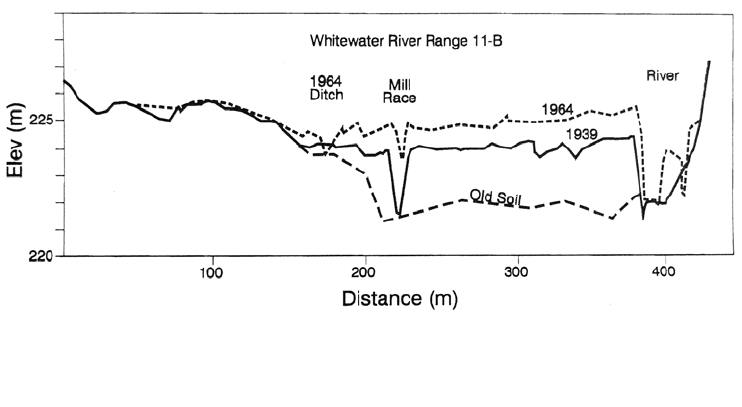
Happ (1975) concluded that valley sedimentation may account for as much as 75
percent of the sediment yield in some agricultural watersheds, and illustrated the rapid
aggradation of a valley floor caused by the redeposition of eroded sediment using data
from the Whitewater River (Fig. 6.14). When upland sources of erosion are reduced,
aggraded channels will begin to incise and slowly export the accumulated sediments.
However, eroded sediments that have deposited outside the area affected by channel
erosion may not he remobilized.
Under some circumstances, low sediment delivery ratios can occur even in very small
watersheds. Whitelock and Loughran (1994) examined a 14.1-ha urbanizing basin and
computed total erosion for the 1954 to 1991 period as 714 t and 832 t using the
137cesium and USLE methods respectively. From 137cesium dating of channel sections
in the stream draining the watershed, it was determined that the accumulation of coarse
material accounted for 571 t of the eroded sediment, and the amount of sediment actually
exported from this small basin represented a sediment delivery ratio of 20 to 31 percent,
depending on the erosion estimate used.
The sediment delivery ratio can vary dramatically over both long and short time
spans. Long-term changes will occur as a result of changing land use and the construction
and operation of upstream reservoirs. As long as reservoirs are trapping sediment, the
downstream sediment yield and the delivery ratio will be reduced. However, when
reservoir operation is changed to release sediment, or as the total storage capacity
becomes filled up with sediment, the delivery ratio downstream of the reservoir will
increase.
Sediment delivery ratio can vary dramatically from one event to another, even from a
small area. This may be illustrated using 7 years of data reported by Piest et al. (1975a)
from two Iowa watersheds about 30 ha in area, contour-planted in corn. Average annual
values of sediment delivery ratio varied from 4 to 67 percent in one watershed and 6 to
61 percent in the other. The delivery ratios computed for 55 individual events over the 7-
yr period reflected even more dramatic variation. For instance, one 14-mm rainfall in
May produced a delivery ratio of 554 percent, while a 17-mm July rainfall, in another
year in the same watershed, produced a delivery ratio of only 1 percent. Seasonal change
in crop cover is a major factor causing these extreme variations. Delivery ratios in excess
of 100 percent were reported for 24 of the 55 events, reflecting the limited ability of
USLE to predict total erosion from individual runoff events.
FIGURE 6.14 Sediment redeposition and valley floor aggradation on the floodplain of
Whitewater River, Minnesota, due to accelerated upland erosion (Happ, 1975).
EROSION 6.31
6.11.5 Estimating Sediment Delivery Ratio
While established methods are available for estimating the rate of erosion from farm-size
areas, there is no generally accepted method for determining the percentage of eroded
sediment that will be delivered to the basin outlet. Haan et al. (1994) pointed out that the
degree of understanding of sediment delivery ratios is probably less than any other area
of sedimentation.
Within some physiographic regions, a power relationship may be developed between
delivery ratio and basin area which plots as a straight line on log-log paper. For example,
the dataset presented by Renfro (1975) for the Blackland Prairie area in Texas produces
an equation for percent sediment delivery ratio (SDR) in the form SDR = 62.1 (area)
-0.1419
for areas from 1 to 250 km
2
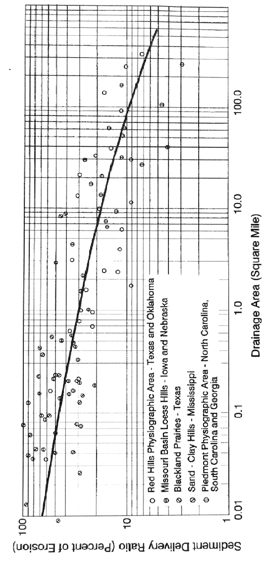
. Boyce (1975) stated that the relationship of sediment-yield
to drainage area usually differs from the sediment-delivery to drainage area relationship
by only a constant, and summarized several relationships for sediment delivery ratio (Fig.
6.15). In regions having uniform landforms and the data required to construct a regional
relationship, this can represent a reliable approach available for estimating sediment
delivery. However, generalized delivery ratio versus area curves do not take into account
topographic, geologic, climatic, land use, and other differences that affect delivery ratios,
and caution must be used to apply these relationships only to landscapes similar to those
for which the relationship was developed. When estimating sediment yield based on
delivery ratio data from other watersheds, compare conditions in the watersheds to look
for conditions such as reservoirs (including farm ponds) which may significantly
influence delivery ratios. Where an upstream reservoir is present, the sediment delivery
may be computed to the reservoir, and the sediment discharge below the reservoir
computed on the basis of sediment release efficiency determined from the Brune curve.
Problems will arise if this method is used to assign delivery ratios to sub-watersheds,
since the sum of the delivered sediment from the sub-watersheds will exceed that
computed for the entire basin.
Some researchers have estimated delivery ratios based on a description of channel or
land use conditions. In the Ryan Gulch basin in northwestern Colorado, a semiarid
undeveloped watershed receiving 330 to 510 mm of average annual rainfall moving from
an elevation of 1860 to 2620 m, Hadley and Shown (1976) developed the sediment
delivery ratios given in Table 6.5. For a suburban basin in Wisconsin, Novotny et al.
(1979) presented the delivery ratio guidelines given in Table 6.6.
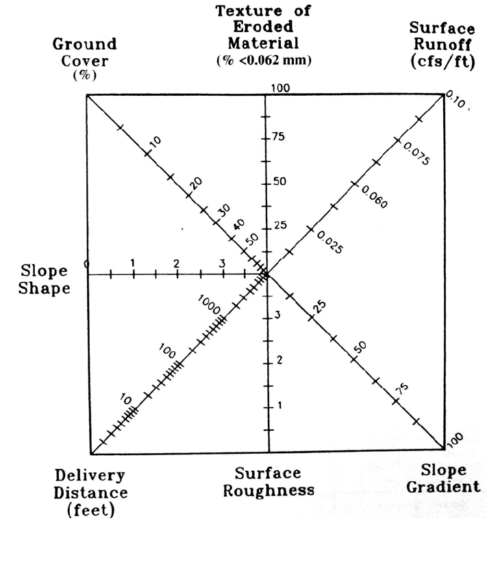
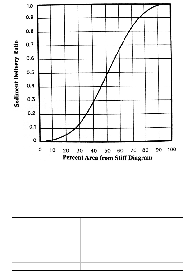
The U.S. Forest Service (1980) has developed a method to estimate sediment delivery
ratio for a single storm based on USLE/RUSLE estimates of erosion, using the stiff
diagram shown in Fig. 6.16. The surface runoff term (ft
3
/s/ft) represents peak discharge
per unit of slope width. The texture of eroded material is expressed as the percentage that
is smaller than sand. Ground cover factor is the percentage ground cover between the
erosion source and the nearest channel and includes both living plants and litter, with a
value of zero corresponding to bare soil. The slope shape between the source area and the
nearest channel is defined as 0 for a convex slope, and 4 for a concave slope, which has a
greater tendency to trap sediment. Delivery distance is measured from the source area to
the channel. Surface roughness values for the soil are assigned on a subjective basis with
using 0 for a smooth surface and 4 for a very rough surface. Slope gradient is the average
slope from the source area to the nearest channel. After all the values have been plotted
on each axis, the plotted points are connected to form a polygon and the percentage of the
total area of the rectangle contained within the polygon is measured. This percentage area
from the stiff diagram is applied to the curve in Fig. 6.17 to determine the sediment
delivery ratio. This procedure applies only to the sheet erosion processes predicted by the
USLE/RUSLE model for small land management units. Channel erosion, including
roads, is often the primary erosion source in forests and must be analyzed separately, as
EROSION 6.32
FIGURE 6.15 Sediment delivery ratios from selected areas in the United States (Boyce, 1975).FIGURE 6.15 Sediment delivery ratios from selected areas in the United States (Boyce, 1975).

EROSION 6.33
TABLE 6.5 Guidelines for Evaluating Relative Sediment Delivery in Ryan Gulch basin,
Colorado
Delivery ratio Channel condition
1.0 Unvegetated gullies with no deposition
0.75 Unvegetated gullies with sediment deposits
0.5 Gullies healed with vegetation indicating shallow flows
0.3-0.5 Channels, intermittent gullies
0-0.4 Shallow, vegetated, ungullied, or braided channels with evidence of
deposition such as active alluvial fans or sediment deposits on
bottomlands where flows spread naturally or are used for irrigation.
Source: Hadley and Shown (1976).
TABLE 6.6 Sediment Delivery Ratios Estimated for Land Uses in Menomonee River
Basin, Wisconsin
Sub-basin type
Impervious
area
Degree of storm
sewering, %
Sediment delivery
ratio, %
Agricultural <5 0 1-30
Developing-construction <5 20-50 20-50
Low-density residential,
unsewered
<20 0 <10
Parks <10 0 <3
Medium-density residential,
partially sewered 30-50 <50 30-70
Medium-density residential.
sewered 30-50 >50 70-100
Commercial, high-density
residential. sewered
>50 80-100 100
Source: Novotny et al. ( 1979).
well as downstream deposition processes in channels and floodplains. Erosion rates
reported from unsurfaced roads are given in Table 6.7.
6.11.6 Sediment Sorting and Enrichment
Use of a single delivery ratio value obscures the complex processes involved in the
transport and sorting of sediment from the source area, through the basin, and into a
reservoir. These processes not only produce wide spatial and temporal variability in the
rate at which eroded sediment is delivered to a downstream point, but through selective
transport and deposition, the character of the transported material also changes as
compared to the erosion source (Walling, 1983). The selective erosion and transport of
the finer-grained material, and preferential deposition of the larger grains, causes eroded
EROSION 6.34
sediment to become enriched with respect to the clay fraction and the associated organics,
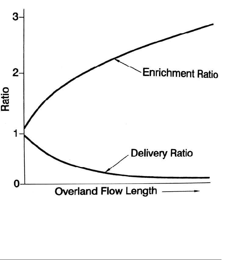
nutrients, and contaminants as compared to the erosion source. The enrichment ratio of a
given constituent is the ratio of concentration in the eroded material and its concentration
in the source material. The enrichment ratio may be either greater or less than unity, and
for any constituent the enrichment ratio and delivery ratios tend to be inversely related
(Fig. 6.18). As a result of enrichment, the sediment delivered to a reservoir tends to be
finer than the material at the point of erosion.
FIGURE 6.16 Stiff diagram (used with Fig. 6.17) to estimate sediment delivery in foreste
d
areas from the USLE model (U.S. Forest Service, 1980).
EROSION 6.35
FIGURE 6.17 Conversion curve, to be used in conjunction with the stiff diagram in Fig. 6.16 fo
r
estimating sediment delivery to channels, from erosion rates estimated in forested areas using the
USLE model (U.S. Forest Service, 1980).
TABLE 6
.7 Erosion Rates Reported for Unsurfaced Roads
Approximate erosion
rate, t/km
2
road surface/yr
Lo
cation
Idaho 2,000
Southeastern United States 800-12,000
Coweeta, North Carolina 3,700
California 2,500
Washington, use-dependent 300-66,000
Source: Ward (1985).
EROSION 6.36
FIGURE 6.18 Sediment delivery and sediment enrichment (after Novotny and Olem, 1994).
6.12 CLOSURE
Erosion processes are complex and can vary dramatically in both space and time.
Existing erosion prediction techniques can provide reasonable estimates of long-term
erosion rates for different land uses. However, prediction of single-event erosion and
sediment delivery from complex watersheds is less reliable. Prediction of the sediment
delivery ratio remains the most uncertain step in the estimation of sediment yield based
on erosion models.