Morris & Fan. Reservoir Sedimentation Handbook
Подождите немного. Документ загружается.

SEDIMENT PROPERTIES 5.25
and without a deflocculant to determine the importance of flocculation. In analyzing the
settling velocity of sediment mixtures in the natural state, native water should be used for
the settling test and in all intermediate steps (such as wet sieving); use of distilled water
can significantly alter flocculation mechanisms and settling characteristics.
5.7.2 Organic Material
Suspended organic material including algae may be present in suspended sediment sam-
ples. The organic component of a sediment sample may be determined as loss on ignition,
which represents the difference between the weight of the oven-dried sample and the
weight after organics are volatilized at 500°C in a muffle furnace. Organic matter may
also be oxidized within a water sample by the addition of a 6 percent solution hydrogen
peroxide at the rate of approximately 5 mL per gram of dry organic matter contained in a
40-mL aliquot of water. Stir, cover, and allow to sit. When the reaction nears completion,
heat to 93°C and stir, adding more hydrogen peroxide if necessary to complete the
reaction (Guy, 1969). This procedure will influence results when the settling rates of
fines are to be measured in native water, since organics can influence flocculation.
5.7.3 Separation of Sand and Fines by Sedimentation
The coarse and fine fractions may be separated by the sedimentation method in which the
sample is introduced into the top of a sedimentation tube. After a time interval sufficient
for all the particles greater than 0.062 mm in diameter to reach the bottom, computed
from Stokes' equation on the basis of fall depth and water temperature, the settled portion
of the sample may be withdrawn and analyzed in a VA tube and the remainder by the
pipet method. Simple sedimentation will not give sharp separations between fine sand
and coarse silts, and silts and clays can settle rapidly as a turbidity current within the
column. Multiple sedimentation separations may be required to overcome these
problems. An alternative method, wet sieving, may be used.
5.7.4 Dry Sieving
The grain size distribution of sands and gravels is normally determined by mechanically
sorting a representative sample using sieves. The sieve diameter approximates the nom-
inal grain diameter. Larger-diameter sieves [203 mm (8 in)] and mechanical vibrators are
normally used to sort large-volume samples, but smaller sieves [e.g., 76-mm (3-in)
diameter] are more appropriate for small sample volumes such as those obtained from
suspended sediment sampling. The analysis requires a balance having a sensitivity equal
to 0.1 percent of the total sample weight. Sieves are arranged with the coarsest size on
top, and the dry sample is passed through the stacked sieves by mechanical agitation for a
minimum of 5 min by a combination of rotational and jarring action, but the sediment is
never manipulated by hand. After agitation, all the sediment retained on each sieve is
removed, including grains trapped in the wire mesh. The weight of the sediment passing
the finest sieve is weighed first, and then the sediment retained on each successive sieve
is added to the first and weighed. The resulting cumulative weights are converted into
percent of total weight and then plotted to produce the grain size distribution curve.
If the sample size is too large, one or more of the sieves will become overloaded,
inhibiting the passage of fines through the mesh and producing an erroneously coarse
distribution. Samples too large for sieving may be reduced by commercially available
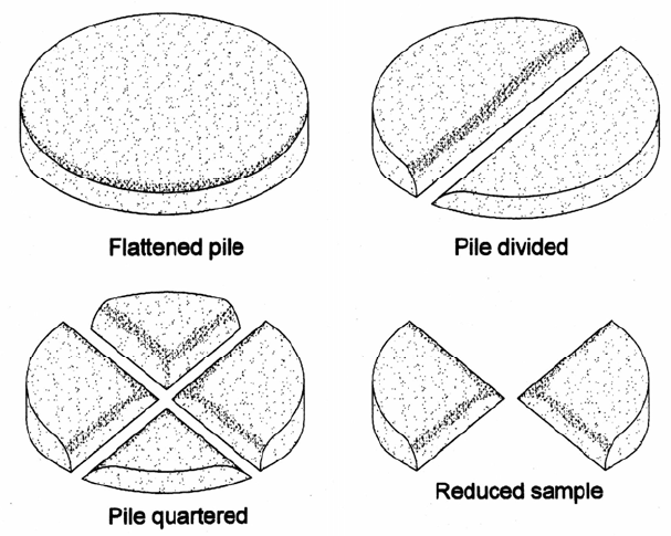
sample splitters or the quartering method (Fig. 5.15). The split must be performed on the
entire sample volume collected in the field to obtain an accurate subsample, since agi-
tation during transport and handling sorts the grains by size within storage containers.
Sample splitting can be a source of significant error and must be performed carefully.
SEDIMENT PROPERTIES 5.26
FIGURE
5.15 Quartering method for splitting a dry sample (after Driscoll,1986).
5.7.5 Wet Sieving
When appreciable fines are present it will be necessary to split the fines from the coarser
material, then use different methods to size each fraction. Dried samples containing mix-
tures of sand and fines can form hard clumps, making the sample unsuitable for dry siev-
ing. In this case wet sieving can be used to separate the fine and coarse particles and to
size-classify the latter. All sieves are washed with a wetting solution, rinsed, then
immersed in a shallow water-filled container so the screen is about 0.5 cm below the
water, taking care that no air remains trapped, and if necessary breaking the surface ten-
sion at one corner of the screen by blowing through a straw to allow the release of
trapped air. The sample is passed through one sieve at a time, starting with the coarsest
mesh. The material passing each screen is captured in the container and applied to the
next smaller screen, and the material retained is dried and weighed. This procedure
continues to the 0.062-mm screen, and the fines passing this sieve are analyzed
separately. If total sand is less than 20 percent of the sample, wet sieving can be
accomplished by using a gentle jet of water to wash the sample through a set of stacked
sieves (Guy, 1969).
5.7.6 Direct Measurement of Nominal Diameter
The nominal diameter of larger grains may be determined by immersion into a cylinder
with a volumetric scale. The cylinder diameter should not exceed twice the grain
diameter. Compute nominal diameter from the displaced volume and the equation for the
volume of a sphere: V = (4/3) r
3
, or d = (6V/)
1/3
SEDIMENT PROPERTIES 5.27
5.7.7 Visual Accumulation Tube
The visual accumulation (VA) tube method provides a fast, economical, and accurate
method of determining the fall velocity (and thus the sedimentation diameter) of sand
size sediments. Unlike sieves, which measure particle physical dimensions from which
hydraulic properties must be computed, the VA tube measures fall velocity directly. The
sand should be separated from the finer material by wet sieving or sedimentation, and the
fine fraction of the sample sized by the piper method. In the VA tube analysis, all
sediments are introduced simultaneously at the top of the water column and become
stratified within the column according to differences in fall velocity. Grains reaching the
bottom at any instant are of the same sedimentation size, and the size gradation is based
on the standard fall diameter. Taller and larger-diameter tubes are required to analyze
larger-volume samples containing larger-diameter grains. The accumulation depth of
sediment at the bottom of the tube is monitored visually, recorded, and graphed to
determine the amount of sediment as a function of sedimentation diameter.
5.7.8 Pipet Method
Sediments smaller than 0.062 mm may be size-classified by the pipet method. This
method determines the concentration of a suspension at a series of predetermined depths
as a function of settling time. A pipet is used to withdraw water at intervals from about
30s to 3 h (depending on water temperature), and the solids concentration from each
sample is determined by evaporation. Larger, faster-settling particles pass beyond the
sampling point, and the maximum sedimentation diameter of each sample is determined
from Stokes' law. When sand-size particles are present in the sample, they are separated
by wet sieving, then mechanically classed by dry sieving.
5.7.9 Bottom Withdrawal Method
The bottom withdrawal (BW) tube method is normally used to measure fines, but can
measure sands up to 0.35 mm in diameter if a higher initial sediment concentration is
used in the tube. For analyzing a large number of samples, the pipet method is less time
consuming and possibly more accurate than the BW method (Guy 1969). The BW tube
method is based on drawing volumes of water from the bottom of an 80- or 100-cm col-
umn of water-sediment mixture at intervals over a period up to about 8 h, with the dura-
tion of the test and withdrawal intervals dependent on water temperature (viscosity) and
size distribution in the sample. Each withdrawal represents the amount of sediment in a
given sedimentation diameter class. The withdrawn samples are transferred to evapo-
rating dishes, dried, weighed, and used to size-classify the sample.
5.7.10 Hydrometer
A hydrometer may be used to determine the grain size distribution of fine-grained sed-
iment. Because a large sample size is required, it is suitable for size-classification of
samples of bottom sediments, or of suspended sediments at high concentrations (greater
than 30,000 mg/L). In this test, about 50 g (dry weight) of sediment is placed into a 1-L
sedimentation cylinder and intensely agitated for 1 min by inverting the stoppered cylin-
der back and forth once per second. Dry samples should initially be soaked 16 h in water
prior to testing. Hydrometer measurements are read at intervals of 2, 5, 15, 30, 60, 250,
and 1440 min following agitation. The hydrometer is carefully placed in the cylinder
about 20 s prior to each reading and is removed immediately thereafter and cleaned by
spinning in demineralized water. A correction for hygroscopic water is made by com-
paring air-dried to oven-dried (110°C) weights of a 20-g subsample of the material. The
percentage of the total sample remaining in suspension, at the level at which the
SEDIMENT PROPERTIES 5.28
hydrometer is measuring the density of the suspension, is calculated from equations spe-
cific to each type of hydrometer. Stokes' law is used to compute the sedimentation
diameter corresponding to each reading.

CHAPTER 6
EROSION
Most sediments enter reservoirs as a consequence of rainfall erosion and subsequent
transport by streams. Successful reduction of sediment yield requires accurate conceptual
and quantitative models of the erosion and transport processes responsible for sediment
delivery to the impoundment. Watershed management programs frequently fail to reduce
sediment yield, despite large expenditures, because the physical nature of the problem is
not properly diagnosed, or the economic and cultural conditions leading to accelerated
erosion are not addressed and erosion control practices are abandoned as soon as
subsidies are removed. Furthermore, because eroded sediments may be flushed
downstream through stream channels over a period of decades or longer, it is essential to
differentiate between the volume of material eroded from the land surface and the amount
which is actually transported into the reservoir, the sediment yield. Both erosion and
delivery processes must be understood to assess erosion impacts on downstream
reservoirs.
Erosion processes have been intensively studied for many decades, with much of the
original impetus for scientific erosion research arising from the dust bowl conditions in
the midwestern United States during the 1930s. Today the computational tools for
modeling soil erosion and related watershed processes are undergoing rapid change and
enhancement, the product of decades of research combined with microcomputer
technology. This chapter introduces basic erosion concepts and measurement techniques,
outlines several modeling techniques available for estimating soil erosion, and describes
the linkages between erosion and sediment yield. Sediment yield is addressed in Chap. 7,
and erosion control practices are outlined in Chap. 12.
6.1 CONCEPTS AND DEFINITIONS
Weathering is the process of chemical and mechanical activity which causes rock to
change in character, decay, and finally crumble into soil. Physical weathering involves
particle fragmentation and may be caused by freezing and thawing, abrasion during
transport, and biological activity. Chemical weathering involves dissolution of the earth's
crust by water, and is accelerated when water is acidified by carbon dioxide released
during respiration by plant roots and soil fauna. The rate of chemical weathering depends
heavily on water availability and is slow and incomplete under arid conditions, leaving
physical weathering to predominate. As a result, soils formed under arid conditions are
more likely to be coarse-grained. Physical processes such as freeze-thaw cycles and
glaciation also prevail in high mountains. Chemical processes are more important in
humid regions, and clay soils predominate. Quartz is the most chemically stable mineral
found in abundance in crustal rocks and is extremely resistant to dissolution by water. It
is the primary constituent of most sands and their morphological counterparts such as
streambeds and beaches
Erosion is the process whereby earth or rock material is loosened or dissolved and
EROSION 6.2
removed from any part of the earth's surface. Whereas weathering involves only the
breakdown of rock, erosion additionally entails the detachment and transport of
weathered material from one location to another, denuding the earth's surface and
delivering sediment to the fluvial system. Erosion rates are frequently measured on small
fractional-hectare plots.
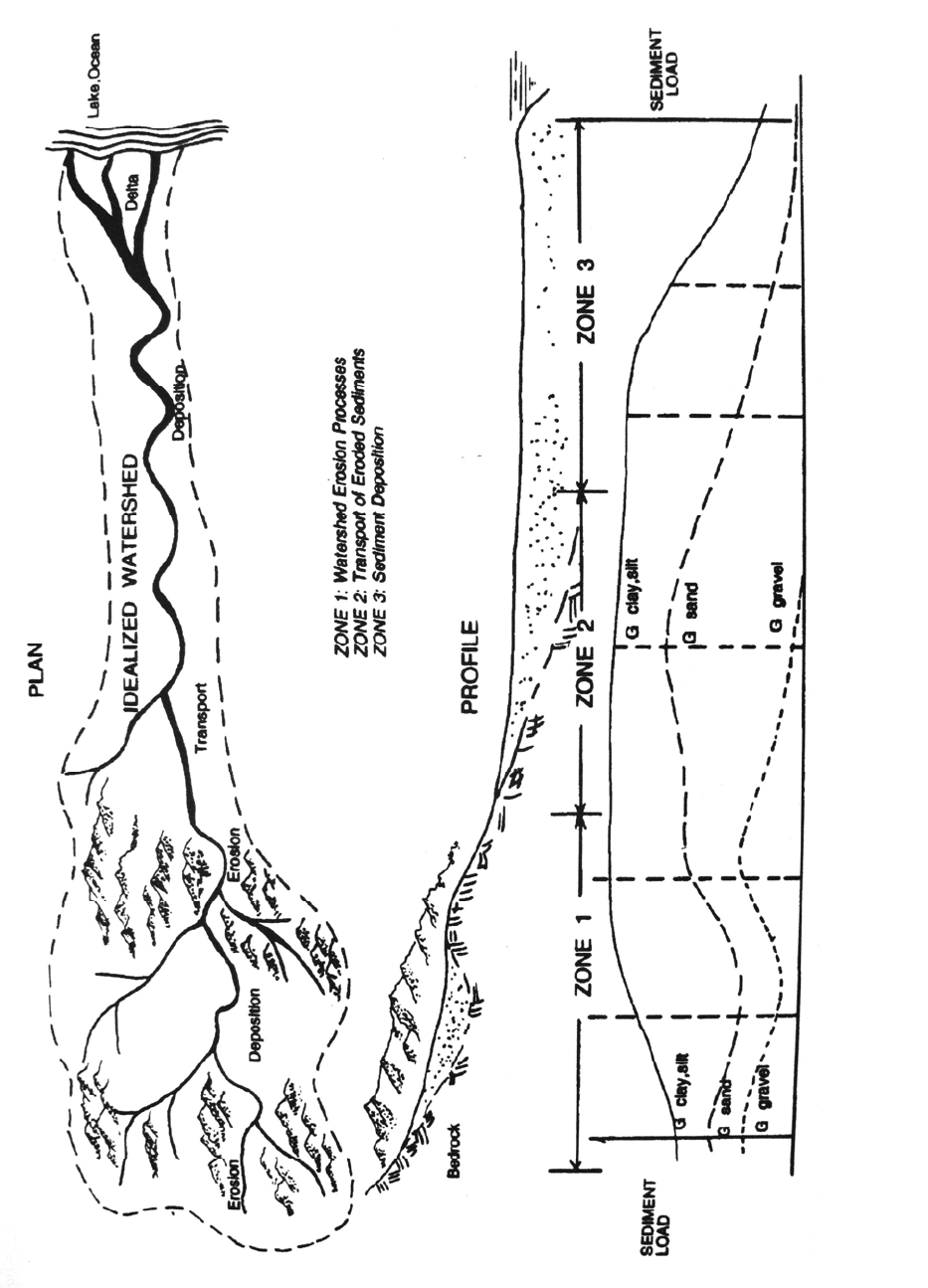
The landscape and associated fluvial transport system may be divided into zones
where either erosive or depositional processes dominate (Fig. 6.1). Erosional processes
predominate in mountainous environments while deposition predominates on flood-
plains, although both erosion and depositional processes occur simultaneously in virtually
all environments. Thus, material eroded from mountain slopes may be deposited in alpine
valleys, and floodplain deposits are eroded by stream channels.
On a global scale and under natural conditions, the denudation of the earth's surface
by the chemical solution of rocks by water and biological processes is more important
than the mechanical erosion. In general, the long-term rate of soil formation may be
considered to balance the natural or geologic rate of erosion. Human activity that
eliminates protective vegetative cover, destroys the soil structure, and concentrates runoff
so that gullying occurs can accelerate erosion by 2 or 3 orders of magnitude compared to
the geologic rate of erosion. The recovery period is the time required for a disturbed site
to become re-vegetated and stabilized, and return to erosion rates more typical of natural
conditions.
Sediment yield is the amount of eroded sediment discharged by a stream at any given
point. It represents the total amount of fluvial sediment exported by the watershed
tributary to a measurement point, and is the parameter of primary concern in reservoir
studies. Because much eroded sediment is re-deposited before it leaves a watershed, the
sediment yield is always less than, and often much less than, the erosion rate within that
same watershed. The ratio between the erosion rate and sediment yield is the sediment
delivery ratio.
The susceptibility of a soil to erode is termed erodability and depends on the size and
physical characteristics of the particles and the nature of the organic and inorganic
materials that bind them together. The erosive forces acting on a soil are determined
primarily by rainfall intensity, slope angle and length, and cover (e.g., vegetation) which
protects the soil against direct raindrop impact.
Erosion may be classified according to the erosive agent (water or wind), the erosion
site (sheet, rill, interrill, gully, channel), or the erosive process (e.g., raindrop, channel,
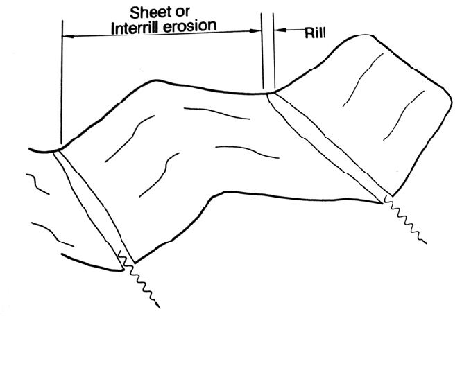
mass wasting). Interrill erosion or sheet erosion is the detachment and transport of soil
particles due to rainsplash and shallow prechannel flow. Rill erosion is the detachment
and transport of soil particles by concentrated flow in small channels or rills not more
than a few centimeters deep that are eliminated by normal cultivation techniques (Fig.
6.2). Interrill erosion delivers sediment to rills, which in turn discharge to gullies or
channels. Both interrill and rill erosion have traditionally been treated as a single process,
since most erosion plots measure the combined effects of both. However, interrill and rill
erosion processes are quite distinct, as is the soil's resistance to each type of erosion.
Measurements on 56 soils using simulated rainfall showed that rill and interrill erosion
rates on the same soil for the same rainfall are poorly correlated, and recent research has
been focused on separately determining interrill and rill erosion rates (Laften et al.,
1991b). A gully is an erosional channel, usually ephemeral, too large to be removed by
normal cultivation techniques or to be crossed by a wheeled vehicle.
Gully erosion and channel erosion may refer to either the gradual or the massive eros-
ion of the beds and banks of gullies and stream channels. Mass wasting refers to erosion
EROSION 6.3
DISTANCE ALONG RIVER
EROSION 6.4
FIGURE 6.2 Definition sketch of interrill or sheet erosion and of rill erosion.
associated with slope failures, including landslides and similar slope movements. Wind
erosion refers to movement of soil particles by wind. Wind erosion may he important in
arid or semiarid regions as an agent that can transport sediment from ridges into
depressions from which it can subsequently be transported by runoff (Rooseboom,1992).
Total erosion or gross erosion within a catchment is the sum of all types of erosion:
interrill, rill, gully, channel, and mass wasting. The relative importance of different types
of erosion varies from one area to another. Sheet and rill erosion normally predominate
where the land surface has been denuded and disturbed, such as grazing and cropped
lands and construction sites. Glymp (1957) compiled data from 113 U.S. watersheds,
0.25 to 1132 km
2
in area, and concluded that sheet and rill erosion accounted for 90
percent or more of the sediment yield in half of the watersheds. The 1977-79 national
erosion inventory of nonfederal lands in the United States conducted by the Natural
Resources Conservation Service estimated total erosion of 4.8×10
9
t/yr by source, as
summarized in Table 6.1. Erosion from large areas of federally owned range and forest
lands, about 22 percent of the nation's land area excluding Alaska, are not included in the
table, and streambank erosion includes the effect of naturally meandering streams.
Although construction sites contribute only small amounts of the total erosion on a
national scale, they can be locally very important because of their high erosion rate per
unit of land area. In some areas gullying and channel processes account for most erosion,
especially in loessial soils or in forested lands. Mass wasting is important in mountain
areas, and in special cases piping can he important (Barendregt and Ongley, 1977). The
1992 natural resources inventory for the United States (Kellogg et al., 1994) estimated
erosion rates on nonfederal lands nationwide on the basis of about 800,000 statistically

EROSION 6.5
TABLE 6.1 Erosion Sources on Nonfederal Lands in the United States. 1977-79
Erosion source Percent of total erosion
Cropland 37.6
Rangeland 26.5
Streambank 10.6
Forest 8.3
Pasture 6.6
Gullying and streambed 5.7
Roads and roadsides 3.2
Construction sites I .5
Source: Holeman (1981).
TABLE 6.2 Land Use and Erosion Rates in the United States
Land area, 10
2
km
2
Erosion rate, t/km
2
/yr Total erosion, 10
9
t/yr
Land use 1982 1992 1982 1992 1982 1992
Sheet and rill erosion
Cropland 1.704 1.547 920 690 1.568 1.067
Pastureland 0.554 0.510 240 220 0.133 0.112
Rangeland 1.655 1.614 220 220 0.364
0.355
Subtotal 2.065 1.534
Wind erosion
Cropland Same Same 740 560 1.261 0.866
Pastureland Same Same 22 22 0.012 0.011
Rangeland Same Same 1054 986 1.744
1.591
Subtotal 3.017 2.468
Combined erosion
5.082 4.002
*Excludes Alaska, includes Puerto Rico and U.S. Virgin Islands.
Source: Natural Resources Conservation Service (1995).
Selected sampling locations, where sheet and rill erosion was determined by the USLE
model and wind erosion by the WEQ (Wind Erosion Equation) model (Table 6.2). Other
types of erosion were not reported. About a 25 percent reduction in erosion rate was
registered between 1982 and 1992, primarily from two causes: improved conservation
practices on cropland and conversion of cropland to noncropland uses, including erodible
land withdrawn under the Conservation Reserve Program which encourages farmers to
plant grass or trees on highly erodible cropland through 10-yr contracts with the U.S.
Department of Agriculture.

EROSION 6.6
6.2 CONSEQUENCES OF SOIL EROSION
6.2.1 On-Site Impacts
Accelerated erosion creates adverse consequences at the site of soil loss and off-site
impacts downstream. On-site impacts are related to reduced productivity on farm,
grazing, and forest lands caused by loss of topsoil, reduction of soil depth, and soil
crusting and sealing. Lal (1994) compiled "frightening" statistics from a variety of
sources indicating that: soil erosion has cumulatively destroyed 430 million ha of
productive land; 3 million ha of agricultural land is lost annually to erosion and another 2
million ha to desertification: the yield of rain-fed agriculture may decrease by 29 percent
over the next 25 yr because of erosion. El-Swaify and Dangler (1982) called soil erosion
the most serious form of land degradation throughout the world.
Erosion accelerates the loss rate of both nutrients and organics from the upper soil
layer. Fines are eroded more rapidly than coarse material, and the loss of fines plus
reduction in soil depth reduces soil moisture retention capacity. When raindrop impact
breaks apart soil aggregates, dispersed clay particles can collect in cracks and pores in the
soil matrix and as a thin (1- to 5-mm) layer on the soil surface that dries to a hard dense
crust of very low porosity which greatly enhances runoff, even on gentle slopes. This seal
can also physically inhibit seedling emergence and reduce oxygen transfer into the soil.
Although the problem occurs in many areas of the world, it is most serious in the
subhumid to semiarid tropics (Sombroek, 1985). Laboratory work by Morin et al. (1981)
showed that the hydraulic conductivity of soil crusts can be 3 to 4 orders of magnitude
smaller than the saturated hydraulic conductivity without soil sealing. Reduction in
moisture availability due to physical changes in the soil structure and reduced infiltration
is a primary cause of productivity declines in eroding soils.
In less developed countries, on-farm economic impacts of erosion tend to exceed off-
site impacts. This reflects the lower level of downstream infrastructure development, less
concern about water quality, and the heavy dependence of small farmers on natural levels
of soil fertility. McIntire (1993) noted that, in less developed areas, the onset of
significant erosion can lead to a pattern of rapid land degradation in which declining
yields and vegetative cover lead to shortened fallow periods, overgrazing, and further
erosion and land degradation.
6.2.2 Off-Site Impacts
Off-site erosion impacts include higher turbidity in rivers, lakes, reservoirs, and coastal
waters and sediment deposition in these same environments and on floodplains.
Reduction in soil infiltration due to erosion will also increase downstream runoff and
flooding, and high sediment concentrations increase the cost of flood damages compared
to clear water flooding. Aquatic ecosystems are heavily affected: sediment loads can clog
spawning gravels, smother the benthos, and adversely affect estuarine and coastal
ecosystems.
Off-site economic impacts tend to predominate in more developed countries because
of the large amount of downstream infrastructure such as reservoirs and waterways that
will he affected by sedimentation, plus adverse water quality impacts on water-based
recreation. In the United States, where water-based recreation is a large economic
activity, impairment of recreational use, and boating in particular, has been estimated to
be the most important single off-farm economic component (Clark. 1985). For example, a
survey of recreational boaters by Robertson and Colletti (1994) revealed that 45 percent
of the respondents decreased their use of Red Rock Reservoir in central Iowa because of
high turbidity, despite its lack of crowding compared to other area reservoirs. On-farm
impacts in industrial countries are mitigated by the availability of fertilizer and other