Morris & Fan. Reservoir Sedimentation Handbook
Подождите немного. Документ загружается.


EROSION 6.17
of the active channel and the adjacent incised floodplain. Streambank erosion rates may
be expressed in terms of tons per stream kilometer per year, and multiplied by the total
stream length in the study area to estimate total streambank erosion. In quantifying
streambank erosion, relatively long time periods and long stream reaches should be used
because channel adjustment is not a continuous or uniform process, and responds to the
episodic nature of hydrologic events. If aerial photography or other data are available at
regular intervals, bank erosion can be computed on an annual basis and graphed as a
function of either total or peak discharge during each period.
Channel deposition and erosion also exhibits seasonal cycles. Differences between
discharge in upstream and downstream fluvial gage stations were used by Miller and
Shoemaker (1986) to detect seasonal changes in sediment storage along a 33-km reach of
the Potomac River in the United States. Temporary channel-bottom, channel-margin, and
channel-island deposition of fine sediment amounted to 14.3 percent of the annual
suspended sediment load.
6.7 SLOPE FAILURE
This section discusses slope failures as a source of sediment in watersheds. Slope failures
occurring directly in reservoirs are discussed in Chap. 10.
Slope failures include phenomena such as landslides, slumps, and debris flows. These
events can produce large volumes of sediment, but they are difficult to quantify because
they tend to occur episodically and in response to extreme events. The initial sediment
load is contributed at the time of slope failure, and additional sediment is contributed
thereafter by rainfall on denuded landslide scars and the mass of destabilized material.
Sediment contribution by slope failure can be measured by using sequences of air photos
to determine the frequency of occurrence and the surface area of the watershed affected.
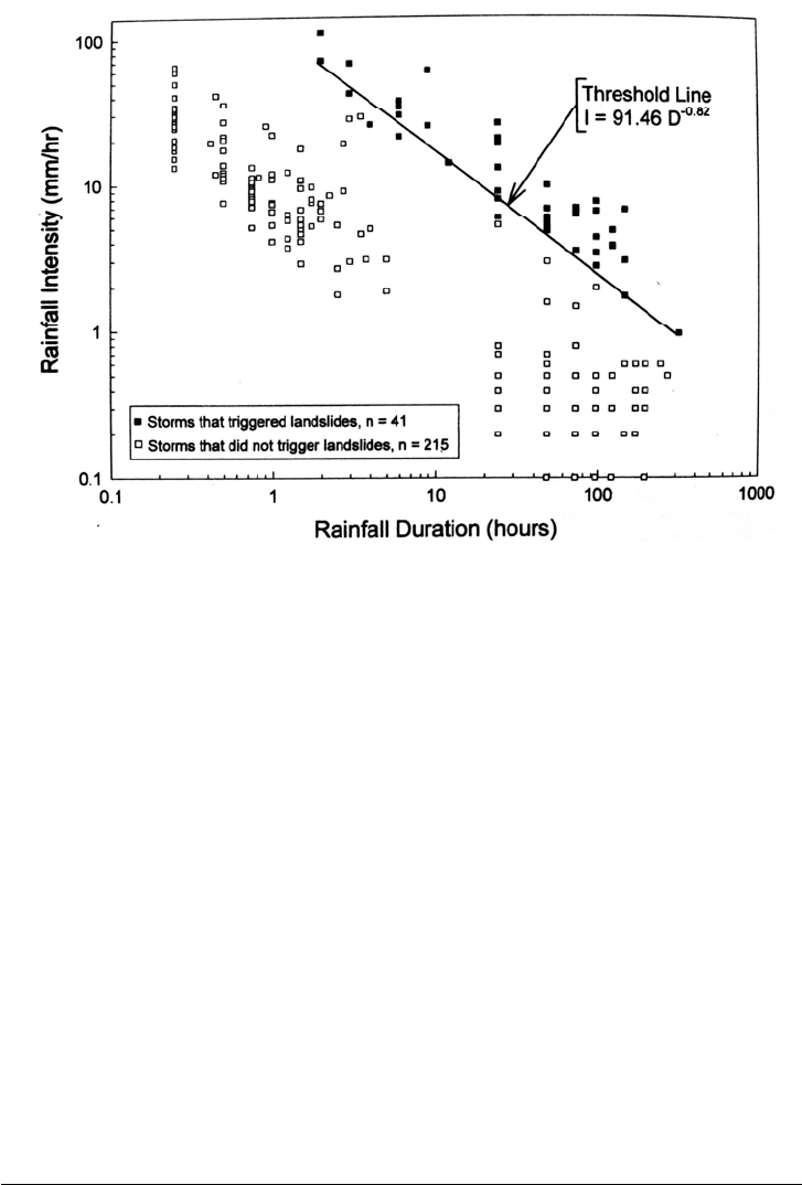
Large-scale landslide activity is triggered by intense rainfall, and the triggering of
landslide activity within a region can be related to rainfall duration and intensity.
Development of a regional relationship in a humid tropical area of Puerto Rico was
performed by Larsen and Simon (1993) based on the analysis of 256 intense rainfall
events. The landslide threshold was developed by comparing rainfall characteristics of
storms that produced landslides with those that did not, resulting in the following
relationship:
I = 91.46D
-0.82
(6.5)
where I is rainfall intensity, mm/h, and D is storm duration, h. The resulting intensity
relationship for Puerto Rico is illustrated in Fig. 6.11. Similar relationships have been
developed in other areas of the world.
Landslide scars are relatively common on steep slopes in the humid tropics, even in
areas of undisturbed forest, and represent an important source of sediment. Erosion
studies underway in the moist Luquillo Experimental Forest in Puerto Rico when
hurricane Hugo struck documented the impact of the hurricane rainfall and resulting
landslips. The experimental forest occupies steeply sloping volcanic soils on the Luquillo
Mountains with a maximum elevation of 1000 m and is essentially undisturbed except for
a sparse network of well-maintained paved roads. Average precipitation in the forest
during this storm was 267 mm, and high-intensity rainfall (over 30 mm/h) was sustained
for about 7 h. The return interval of this rainfall was about 10 yr. Aerial photography was
used to identify 285 landslides in 6474 ha of the forest, of which 66 percent were
concentrated in a 1031-ha area closest to the passage of the hurricane's eye. The surface
area of individual landslides ranged from 18 to 4502 m
2
, with a median of 148 m
2
. In the
1031-ha area of intense landslide activity, landslides affected 0.65 percent of the land
EROSION 6.18
surface. Shallow soil slips (0.5 to 1.5 in deep) and debris flows (1.5 to 2.0 m deep) were
the predominant forms of slope failure and together accounted for 91 percent of
landslides, the remaining 9 percent being slumps. Virtually all the mapped landslides
occurred in areas receiving over 200 mm of rain during the storm (Larsen and Torres-
Sanchez. 1992). However, extensive channel or valley floor modification was not
observed in the forest area, nor did any of the road culverts fail despite debris clogging
(Scatena and Larsen, 1991).
FIGURE 6.11 Intensity of rainfall that triggered landslides in Puerto Rico based on 256 storms
over the period 1959 to 1991. (After Larsen and Simon. 1993).
The analysis of aerial photography for the Luquillo moist tropical forest spanning the
period of 1941 to 1990 showed that small mass movements with a median area of 156 m
2
could be expected to affect about 0.64 percent of the land area per century. The resulting
rate of mass wasting on forested slopes was estimated at 188 m
3
/km
2
/yr or 239 t/km
2
/yr.
By comparison, suspended sediment export from forest streams ranges from 159 to 203
t/km
2
/yr, and the combined suspended and bedload from another similar forest stream is
300 t/km
2
/yr (Larsen. 1991). On the basis of
10
beryllium measurement, Brown et al.
(1995) estimated that about 55 percent of the sediment exported from the forest is
mobilized by mass wasting and the remainder from sheet erosion.
6.8 FIELD MEASUREMENT OF EROSION
Erosion rates are measured in the field to provide the data needed to construct and
calibrate erosion prediction models, to test the effectiveness of alternative erosion control
measures, and to demonstrate erosion and control processes to audiences such as farmers
and policy makers.
EROSION 6.19
6.8.1 Erosion Plots
In agricultural practice, sub-hectare plots are used to measure the rate of soil loss under
different conditions of soil type, slope, cropping pattern, and climate. Tens of thousands
of plot-years of data are now available and have been used to calibrate the USLE and
RUSLE models (described in Sec. 6.9). The standard USLE agricultural plot is 22.6 m
long along a 9 percent slope axis and is about 4 m wide (plot width is adjusted to an even
multiple of row widths). Plots of other dimensions and slopes are also used. Sheet metal
borders are driven into the ground around the plot to exactly define its size. All runoff is
captured and passed through tanks where the sediment is trapped, then removed and
weighed. Field plot techniques are described by Mutchler et al. (1994), who emphasize
the importance of the USLE standard plot because of the extensive existing database
collected in a generally uniform manner and the proven usefulness of the USLE/RUSLE
equations.
For the separate calibration of interrill and rill erosion rates as required for the newer
WEPP model, Laften et al. (1991b) measured interrill erosion in multiple plots 0.5 m
wide and 0.75 m long, and rill erosion was measured in plots 0.5 m wide and 9 m long,
under simulated rainfall. Soil loss from small sloping areas can also be measured with
troughs, or pairs of troughs upstream and downstream of the sampled portion of the
slope. All trough runoff is directed into sediment traps.
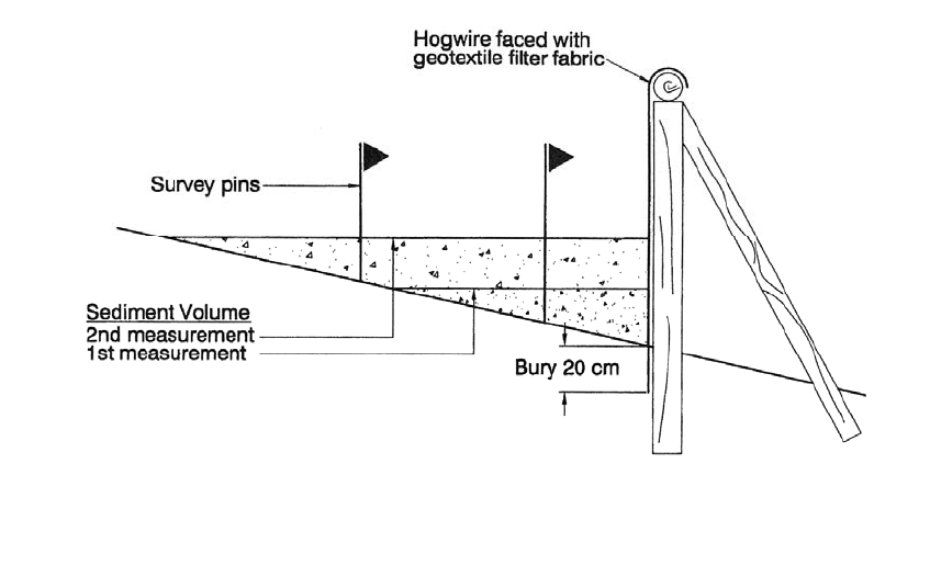
6.8.2 Fabric Dams
Fabric dams represent an inexpensive method of comparing erosion rates from different
land uses and, because the results are readily visible, they are also useful for
demonstrations. As a disadvantage, runoff volume cannot be measured. Dissmeyer
(1982) described fabric dam construction for monitoring of forestry practices using rot-
resistant posts, hogwire or similar coarse wire mesh, and geotextile or other filter fabric
(Fig. 6.12). The filter fabric is selected for the soil size it is intended to trap and the
expected runoff volume. Sediment is trapped by the pores in the fabric plus the reduced
flow velocity behind the darn. Plot size should be adjusted to prevent dam overtopping,
and in areas of mechanically disturbed soils, such as construction areas, plot length
should normally not exceed 30 m. Plot widths of about 10 m are recommended, with
space between adjacent plots. Plots comparing results of different treatments should be
established in areas having similar soils and slopes, and rainfall should be measured.
Sediment accumulation may be measured by repeated topographic survey or using a
square grid of stakes on 0.5 m centers, with lengths marked from zero upward along each
stake. Core the full depth of sediment, dry, and weigh to determine the volume to weight
conversion to express erosion rates in terms of mass per unit surface area.
6.8.3 Experimental Watersheds
Some agricultural studies and most forestry studies employ instrumented watersheds
ranging in area from 1 to over 100 ha, in combination with smaller plot studies to analyze
local erosion sources such as logging roads. Forestry is normally practiced on soils
having steep and irregular slopes, and the erosion rates from haul roads is typically orders
of magnitude higher than from the forest floor. The resulting pattern of soil disturbance
caused by logging is much more irregular than by mechanized agriculture. The use of
small instrumental watersheds instead of sub-hectare plot studies helps to even out some
EROSION 6.20
FIGURE 6.12 Fabric darn for erosion control studies (adapted from Dissmeyer, 1982).
o
f this inherent variability to allow a better comparison of the impacts of alternative
forest management techniques. Data from experimental watersheds provide information
on sediment yield which is not strictly comparable to the erosion rate measured in small
plots. and differences in drainage area size and delivery ratio must be considered in
comparing data from the two sources.
6.8.4 Measurement Equipment
Measurement equipment and sampling strategies must be selected on the basis of the
study requirements. Total runoff collection devices are not generally feasible for areas
other than small plots because storage requirements are excessive. Inadequate storage can
produce overflow and sediment loss during large events responsible for the highest
erosion rates, which are most important to sample accurately. Sample volume may be
reduced by using a slotted flow divisor to obtain a storm-integrated or discharge-
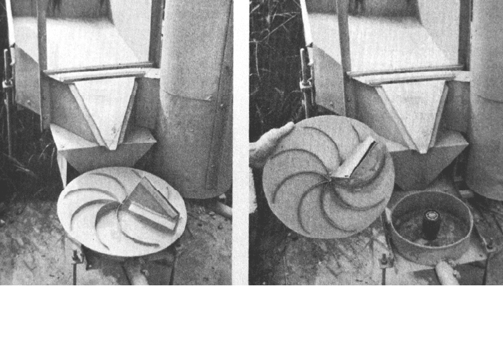
weighted sample of the runoff. The multi-slot divisor equally divides the flow among an
odd number (from 3 to 13) of stationary slots. The Coshocton wheel sampler uses a
revolving slot to sample between 0.33 and 1 percent of the flow (Fig. 6.13). Flow divisors
are typically placed downstream of an H-type flume which measures total discharge. This
flume has a flat bottom that reduces clogging by sediment and is simple to build.
Construction details for samplers, flumes, and other devices including the "Walnut Gulch
supercritical flume" developed for the measurement of ephemeral, flashy, and sand- and
gravel-laden streams, are provided by Brakensiek et al. (1979). Modified sampling
equipment is described by Replogle and Johnson (1963).
EROSION 6.21
FIGURE 6.13 Coshocton wheel sampler and H flume (Wendy et al., 1979).
The timewise variation in suspended sediment discharge during individual runoff
events can be sampled using a continuous stage recorder and automatic sampler, as
described in Chap. 8. In forested watersheds discharging coarse channel sediment and
woody debris, a debris basin with an overflow weir and suspended load sampler
represents a good measurement option. The discharge of coarse sediment is measured by
repeated surveys of the debris basin to determine the volume trapped, and the
measurement is corrected for the amount of woody debris.
6.8.5 Simulated Rainfall
Rainfall simulators have been used in substitution for natural rainfall in field erosion
studies on plots up to about 1 ha and in laboratory studies of microscale erosion
phenomena (Meyer. 1994). The field simulator consists of an array of nozzles or other
drop-forming devices suspended in the air on a framework of pipes or other structural
members, and fed by pumps and hoses. Because of their large water requirements, the
larger simulators are usually supplied from a pond or other local water body.
The ideal simulator should produce drops having a size distribution near that of
natural rainstorms, the drops should fall nearly vertically, and the application should be
nearly continuous and uniform over the study area at the simulated storm intensities. The
simulator should be capable of producing any simulated storm repeatedly on different
plots, and should wet an area large enough to provide realistic results. The system should
be portable for movement from one plot to another and operate satisfactorily in a variety
of field conditions. Additionally, the simulated rainwater should be free of sediment and
its chemical characteristics should be sufficiently similar to natural rainfall so that soil
aggregation characteristics are not significantly altered. No simulator achieves all these
goals perfectly, and tradeoffs are inevitable. There is no accepted standard for rainfall
simulators; a variety of custom devices have been developed for different applications.
EROSION 6.22
Rainfall simulators do not substitute for natural storms but have important advantages
in certain types of work. They can obtain erosion data from small sites without the time
and expense of establishing a long-term monitoring program. The effect of intense storms
can be simulated immediately as opposed to potentially waiting for years for such an
event to occur under natural conditions. Detailed instrumentation can he installed to
monitor intense simulated storms that would not he possible under natural conditions.
Simulators also allow the response of many types of soils or types of treatments to be
compared under controlled and repeatable conditions over a relatively short period of
time. Simulators may also be useful as an educational or demonstration tool (Dillaha,
1988). However, considerable interpretation is necessary to transform simulator results
into annual erosion values, such as those used in USLE, and rainfall simulators are no
substitute for long-term field plots subjected to natural climatic and rainfall conditions.
6.8.6 Other Methods
Radioactive
137
cesium generated by fallout from nuclear atmospheric testing has been
used to measure and trace erosion and deposition processes on the land and in reservoirs.
Significant fallout of this isotope started in the late 1950s, peaked in 1964, and declined
quickly after the nuclear test ban treaty, although areas of Europe received additional
inputs from the Chernobyl reactor accident.
137
Cesium is tightly sorbed onto clays and
penetrates only a short distance (on the order of 10 cm) into the soil column. It may be
used to trace the movement of fallout-contaminated surface soils through a watershed,
along channels, and to reservoirs and other points of deposition. By measuring rates of
137
cesium activity as a function of depth in the soil profile, it is possible to determine
whether sites are erosional or depositional. and determine deposition depths. It has been
used in numerous studies to examine soil erosion and sediment budgets (Wilkins and
Hebei. 1982; Campbell et al., 1988; Whitelock and Loughran, 1994) and has also been
used to determine the sources of eroded sediment by the "fingerprinting" process
discussed in Chap. 7. However, Fredericks et al. (1988) have pointed out that in soil
erosion studies the
137
cesium method is most suited as a research tool rather than for
routine analysis. Soil samples exhibit a high degree of spatial variability in their
137
cesium levels due to factors such as differences in soil characteristics and highly
localized variations in rates of fallout deposition and soil erosion. Consequently, a large
number (e.g., more than 20) soil samples must be analyzed from each site to reduce the
standard error of mean activity counts to acceptable values. Studies involving over 100
samples are not uncommon, and counting times in a gamma-ray spectrometer typically
run 8 to 16 h per sample. This tracer has also been frequently used for the dating of
reservoir sediments, an application where the spatial variability is less critical since the
objective is merely to identify the most active horizon in a continuously depositional
environment, and not to compare activities among the samples. The use of
137
cesium for
dating reservoir sediments is described in Chap. 10.
Erosion monitoring using pins or nails with washers has been described by Lal et al.
(1990). Erosion pins, or nails with small washers, are set out on a grid across a field and
the decline in soil level is measured over time relative to each nail and averaged across
the study site. This method is inexpensive and unattractive to vandals. However, it is
difficult to obtain representative data since the nail itself obstructs soil movement,
cultivation can artificially displace soil around the nail, and the erosion rate can be
masked in swelling soils. This technique is suitable only for intensely monitored small
plots where the primary interest is in relative rates of erosion and deposition.

EROSION 6.23
The long-term rate of soil denudation can be determined from biological evidence,
such as the exposure of roots on trees, the age of which is determined by counting annual
growth rings (LaMarche, 1967). Biological indicators, such as freshly exposed roots, are
also useful in identifying areas of recent channel erosion in the field.
6.9 EROSION MODELING WITH USLE AND RUSLE
Erosion modeling is fundamental to soil conservation because it allows the likely
effectiveness of alternative conservation treatments to be tested on various landscape
units to determine their impact on soil loss. When combined with economic data on the
costs of alternative methods, the most economically efficient means to reduce erosion can
be identified. The key to erosion modeling is the ability to extrapolate erosion rates
measured at selected research sites to farms and small watersheds. Impacts on larger
landscape units are computed as a sum of the erosion rates in multiple smaller areas, with
an adjustment for delivery ratio.
The Universal Soil Loss Equation (USLE) is the method most widely used around the
world to predict long-term rates of interrill and rill erosion from field or farm size units
subject to different management practices. Wischmeier and Smith (1965) developed the
USLE based on thousands of plot-years of data from experimental plots, and although the
initial focus was oriented primarily to conditions in the middle and eastern United States,
the USLE has been extended and applied worldwide. Metric conversions for the USLE
have been summarized by Foster et al. (1981). The predictive accuracy of the USLE was
checked against 2300 plot-years of soil loss data from 189 field plots at widely scattered
locations by Wischmeier (1975). Average soil loss was 25 t/ha and mean prediction error
was 1.3 t. For the evaluation of forestry practices, Dissmeyer and Foster (1980) combined
the C and P factors into a cover-management factor for utilization of the equation to
predict interrill and rill erosion from forest areas during the recovery period following
logging. In forests the rate of soil loss from logging roads, skid roads, and channels and
gullies is typically higher than sheet and rill erosion. These losses are not computed in the
USLE and must be computed separately by a different method.
In 1987 work began on the development of a Revised USLE (RUSLE) to incorporate
more recent research and technology (Renard et al., 1994). The RUSLE model was
released in 1995 and is distributed as a computer program and manual. (The Windows-
based RUSLE2 software can be downloaded from:
http://fargo.nserl.purdue.edu/rusle2_d
ataweb/RUSLE2_Index.htm ). While it retains the
same basic structure as USLE, algorithms for computing individual factors have been
changed significantly and computerized methods assist in determining individual factors.
The USLE/RUSLE model is an empirical multiple-regression-type equation which
incorporates the parameters that influence erosion, without making any attempt to
simulate the actual erosion process. Both USLE and RUSLE have the following form:
A=R × K × LS × C × P (6.6)
The equation is said to be universal because it includes the four principal factors which
influence soil loss: (1) the inherent erodibility of the soil is expressed by K, (2) erosive
rainfall forces are expressed by R, (3) gravitational forces affecting runoff are given by
the hillside length-slope factor (LS), and (4) cover factors modifying erosive forces are
expressed by C and P. In the equation, A is annual long-term (20+ years) rate of soil loss.
The rainfall erosion index R. is computed as the average erosional potential of rainfall
measured as the product of rainfall kinetic energy and maximum 30-min rainfall intensity
for all significant storms (greater than 12.7 mm, 0.5 inches) during an average year.
EROSION 6.24
The soil erodibility factor K indicates the susceptibility of soil particles to
detachment. This value is measured experimentally and published values are available for
soils in the United States from the Natural Resources Conservation Service and soil
survey reports. Several methods for estimating K values on unstudied soils are provided
in the RUSLE program. Values represent average soil loss from a 72.6 ft (22.1 m) plot
length on a 9 percent slope, per unit of rainfall erosion index R, for bare soil in
continuous fallow. K values depend primarily on soil texture and are modified by
parameters including structure, organic matter, and permeability.
The length-slope factor (LS) indicates effect of slope length and gradient, with LS = 1
for a 22.1 m long experimental plot on a 9 percent slope.
The vegetative cover factor C is the ratio of soil loss under specified conditions to
bare tilled soil. Values may range from 1 to 0.01.
The parameter for erosion control practice P compares the conservation techniques
against a value of P = 1 for straight rows tilled perpendicular to the slope.
Several important improvements over USLE have been incorporated into the RUSLE.
The rainfall erosivity R values have been computed in more detail and incorporate the
reduction in erosivity due to ponding on flat soils. Soil erodibility is varied seasonally.
and alternative methods are presented for estimating K values on soils where data from
field plots are not available. The length-slope factors are evaluated by using four different
length-slope relationships and can incorporate freeze-thaw phenomena. Also, the slope
can he divided into segments to represent complex slopes. Crop cover C and conservation
practice P factor values were updated to better represent present agricultural practice and
now incorporate conservation practices on rangeland.
The USLE/RUSLE model has a large database of plot studies, there are published
values for model parameters, and many workers are familiar with its use. Although
originally developed and calibrated for soil conditions in the United States, the
USLE/RUSLE model has been used successfully in many countries. It has been used to
study watersheds up to several hundred square kilometers in areas where reservoir
sedimentation or fluvial sediment data are available to help determine the delivery ratio
(Stall and Lee, 1980). However, use of the USLE/RUSLE model may lead to large errors
unless values developed for the United States are adapted to conditions in other regions
and confirmed with field studies. For example, Bollinne (1985) found that erosion from
smaller rainfalls (less than 12.7 mm), which are excluded from rainfall erosivity
computations in the United States, produce 33.5 percent of the annual runoff from bare
soil near Brussels and therefore contribute significantly to erosion. Cover and other
factors also required adjustment. In Costa Rica, Cuesta (1994) reported that while the
USLE was at least partially adapted to conditions in that country, it still appears to
overestimate erosion rates by approximately an order of magnitude on some steeply
sloping soils. The adoption of the model to steeply sloping soils is a particularly
important issue: the equation was originally developed and calibrated for use on
mechanizable soils with lower slopes, but in the tropics the steep and nonmechanizable
soils may also he intensely cultivated and erosion prediction in this environment is quite
important. The model also may not properly account for nonstandard farm practices. For
example. Jackson (1988) argued that the USLE tended to overestimate soil loss from
Amish farms in the Pennsylvania area, which are cultivated exclusively by animal power
and include long rotations in forage.
As a limitation the USLE/RUSLE model predicts long term (e.g., 20+ year) interrill
and rill erosion from field- and farm-size units, but no depositional processes are
included. Additional sources of erosion such as gullying and mass wasting are not
considered and must be computed separately. The model is poorly adapted to determine
short-term variations in sediment yield, since it does not simulate physical processes. The

EROSION 6.25
soil erodibility factor K is an average value, but in reality the K value can be expected to
change because of differences in antecedent soil moisture, storm characteristics, and the
timewise dependence between erosion events. Erosion events are not independent of each
other; one erosion event can deplete the supply of readily detached soil available for the
subsequent event. Such antecedent conditions are not considered in the equations and can
introduce significant error in predicting individual storm events. Single-event simulation
can be important in reservoir analysis when it is desired to apportion sediment yield
among the various reservoir inflow events that occur during a year.
6.10 EROSION MODELING USING WEPP
The Water Erosion Prediction Project (WEPP) was initiated in 1986 as a cooperative
effort among four federal agencies: Agricultural Research Service, Natural Resources
Conservation Service, Forest Service, and Bureau of Land Management. The objective
was to replace the USLE with a new generation of erosion prediction technology to
incorporate current understanding of the erosion process. The WEPP model and
documentation is available in compact from the USDA National Soil Erosion Laboratory
at http://www.ars.usda.gov/Research/docs.htm?docid=10621
.
The WEPP model simulates the physical processes affecting erosion. It uses a daily
time step to update plant growth, litter production, soil characteristics, and hydrologic
conditions important for determining runoff and erosion processes. When runoff occurs
the model computes soil detachment, transport, and deposition at multiple points along
the soil profile, in channels, and in small reservoirs. There are three versions of the
model: profile, watershed, and grid. The profile version is a direct replacement of USLE
with important additional capabilities, including the redeposition of eroded sediment and
timewise simulation of erosion with a daily time step. The watershed version is a field-
size model, which also incorporates the profile model and estimates sediment delivery to
channels. The profile model is used to simulate erosion processes from different types of
land uses and treatments. The eroded sediment is routed to the basin outlet by
components in the watershed model which simulate processes of erosion and transport in
ephemeral channels, and through detention reservoirs which trap sediment. The grid
model is designed for application to geographical areas which do not correspond to
watershed limits. Sediment can be delivered from one grid element to another and routed
to multiple discharge points.
WEPP simulates three erosion processes: detachment, transport, and deposition.
Interrill, rill, and channel erosion is simulated as a function of hydraulic shear. It does not
simulate classical gullying, where processes other than hydraulic shear at the channel
boundary are important, nor does it simulate erosion of perennial streams. The size of the
area that can he simulated with the model depends on the erosion processes within the
landscape unit. Thus, in areas of loessial soils where classical gullying may be the
primary form of erosion, the WEPP model may be limited to pre-gully flows from areas
less than 1 km
2
, whereas on other soils it might be applied to areas on the order of 10 km
2
without encountering significant erosive processes not simulated by the model.
The model simulates the hydrologic components important for predicting erosion. It
can use either measured or simulated daily climatic data for storm rainfall amount and
duration, peak:average rainfall intensity ratio, daily temperature range, wind velocity and
direction, and solar radiation. Snow, snowmelt, frost, freezing and thaw depth,
infiltration, and water loss during winter conditions are computed. Plant growth and
decomposition is simulated daily for both cropland and rangeland, estimating values for
variables including canopy cover and height, live and dead biomass above and below the

EROSION 6.26
soil, leaf area index, basal area, and organic residue. Information on the dates and types
of farming operations are input into the model. Daily water budget computations include
precipitation. Evapotranspiration. infiltration, surface ponding, and deep percolation.
Hydraulic shear forces on the soil surface have been computed assuming rectangular rills
spaced about 1 m apart, using the kinematic wave equations and their approximations.
Soil properties estimated each day include random roughness, ridge height, bulk density,
saturated hydraulic conductivity, and soil erodibility parameters for rill and interrill areas,
and critical hydraulic shear. These parameters are adjusted to account for factors
including tillage, plant growth, and rainfall.
Of particular interest to the simulation of processes affecting reservoirs, the WEPP
model can provide detailed simulation of individual storm events, predicting not only the
amount of sediment eroded but also the grain size distribution of the sediment that enters
downstream channels.
Because WEPP simulates both interrill and rill erosion processes, separate erodibility
data on interrill and rill erosion rates are needed. The initial dataset obtained from 56
representative sloping cropland and rangeland soils across the United States under
simulated rainfall revealed that there was little correlation between the two erosion rates.
This reflects the different processes and forces involved in these two erosion processes
and reinforces the need to simulate these two processes separately in erosion modeling. It
was also found that soil erodibility values showed little quantitative resemblance to the
USLE K values determined for these same soils (Laften et al., 1991b).
Interrill erosion is the detachment and transport of soil by raindrops and shallow
overland flow. Sediment delivery from interrill areas is estimated to vary as the square of
rainfall intensity by the following relationship:
D
i
= K
i
G C S I
2
(6.7)
where Di is sediment delivery from the interrill area to the rill, kg/m
2
/s; K
i
is interrill
erodibility; I is the effective rainfall intensity, mm/s; G and C are adjustment factors for
ground cover and canopy cover respectively; and S is a slope adjustment factor.
Rill erosion is the detachment and transport of soil particles by concentrated flowing
water. The rill detachment capacity D
c
in WEPP is estimated for clear water as a linear
function of the hydraulic shear τ in excess of the critical shear stress τ
crit
required to
initiate detachment:
D
c
= K
r
(τ- τ
crit
) (6.8)
where K
r
is rill erodibility. The actual rate of detachment in a rill is diminished as
sediment concentration increases within the rill flow. This actual rill detachment rate D
r
is related to the detachment capacity for clear water by:
D
r
= D
c
(1-G/T
c
) (6.9)
where G is the sediment load. Transport capacity Tc is estimated using an approximation
of Yalin's sediment transport equation having the form:
T
c
= K
t
τ
3/2
(6.10)
where K
t
is the transport coefficient (Finkner et al., 1989).
6.11 SEDIMENT DELIVERY RATIO
6.11.1 Basic Delivery Ratio Concepts
Models such as RUSLE and WEPP determine erosion rates in small areas, and not the
amount of eroded material that is actually delivered to a downstream reservoir. The