Morris & Fan. Reservoir Sedimentation Handbook
Подождите немного. Документ загружается.


EROSION 6.7
inputs to offset erosion impacts on soil nutrient levels. Also, in industrialized countries
crop production conservation techniques are well-developed and actively implemented.
Production occurs on mechanizable soils with low slopes, and steep erodible slopes are
not cultivated.
Several issues associated with the economic evaluation of erosion impacts have been
reviewed by Sanders et al. (1995). From the standpoint of accounting for off-site costs at
reservoirs, they point out that the immediate economic impacts of sediment deposits in
reservoirs depends on whether deposition is focused in the active storage zone or the dead
pool. Because a long time horizon is required to measure soil erosion impacts on crop
productivity in the field, they recommended the use of a calibrated biophysical simulation
model such as EPIC to facilitate research on the physical and economic benefits of soil
conservation alternatives. The EPIC model (Williams et al., 1984) is a multiyear,
multicrop model which simulates crop growth and yields subject to erosion and variable
inputs. The model is data-intensive, operating on a daily timestep, using up to 10 soil
layers, and having 21 parameters for each soil layer. It simulates weather, surface and
subsurface hydrology, erosion, nutrient budget, plant growth, agronomic practices
including tillage, and soil temperature. The data required to run the model are not
presently available for crops in many parts of the world, and the model's extensive data
and validation needs tend to increase rather than diminish the reliance on field data from
agricultural research stations. However, once validated it allows researchers to rapidly
assess the relationship between crop yield and agronomic and conservation practices.
6.3 EROSION RATE
Erosion rate is expressed in terms of mass of soil removed per unit of time (1 t/km
2
/yr =
2.855 short tons/mi
2
/yr). It may also be expressed as the denudation rate of the earth's
surface, measured in soil depth per unit of time. Twelve of the 14 estimates of the
average global rate of denudation summarized by Lal (1994) fell between 0.06 and 0.16
mm/year. The most comprehensive study was reportedly that of Walling (1984) with a
computed global rate of 0.088 mm/yr. Assuming a unit weight of 1.5 g/cm
3
for soil, this
is equivalent to an erosion rate of 132 t/km
2
/yr. Smith and Stamey (1965) reviewed data
on the natural or geologic rates of erosion from many soils planted with thick vegetation,
and found that the geologic rates of erosion from well-vegetated sites are commonly less
than, and usually much less than, 60t/km
2
/yr.
Over much of the earth's surface, the most significant determinant of modern erosion
rates is human activity. The potential impact of human activity in accelerating erosion is
summarized in Table 6.3. Changes in the nature and intensity of land use influence long-
TABLE 6.3 Representative Rates of Erosion from Various Temperate Zone Land Uses
Erosion rate
Relative erosion rate
Land use
short tons/mi
2
/yr
t/km
2
/yr (forest = 1)
Forest 24 8 1
Grassland 240 84 10
Abandoned surface mines 2,400 840 100
Cropland 4,800 1 ,680 200
Harvested forest 12,000 4,200 500
Active surface mines 48,000 16,800 2,000
Construction sites 48,000 16,800 2,000
EROSION 6.8
term erosion rates. Trimble (1974) showed that erosion rates in the Piedmont area of the
southeastern United States rose to very high levels during periods of maximum
agricultural exploitation during the nineteenth and early twentieth centuries, and have
since abated because of abandonment of agriculture in many areas and implementation of
soil conservation practices, starting in the 1930s, in areas remaining under cultivation.
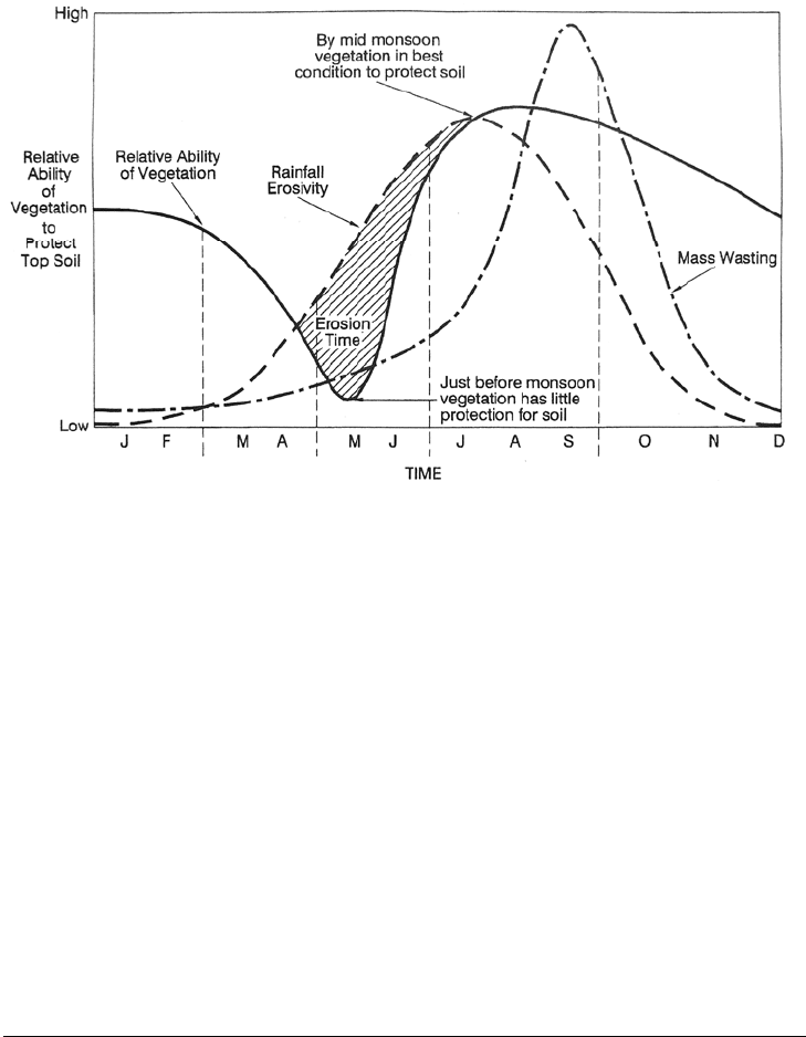
FIGURE 6.3 Seasonality of erosion in Nepal (after Galay. 1987).
Large seasonal variations in erosion rate are caused by factors such as increase in the
supply of readily erodible sediment after a prolonged dry period, changes in soil cover,
and seasonal variation in rainfall intensity. The influence of ground cover is particularly
evident in seasonally dry climates where vegetation is subject to heavy grazing pressure,
or where lands are ploughed prior to the onset of rains. The seasonality of erosion in
Nepal is illustrated in Fig. 6.3 showing high surface erosion rates at the onset of the
monsoon when there is limited ground cover on cropped and overgrazed land. Later in
the season, vegetative cover has become well-established and the supply of readily
erodible loose surface sediment has been exhausted, so surface erosion rates decline, but
higher soil moisture increases the rate of slope failure.
6.4 INTERRILL AND RILL EROSION
6.4.1 Interrill Erosion
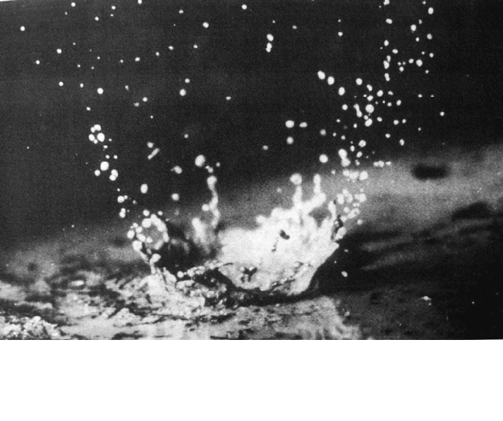
Interrill erosion entails two distinct steps: detachment and transport. The primary cause of
detachment is the impact of rainfall on a soil surface deprived of protective vegetative
cover. Raindrop impact mechanically breaks apart the granular structure of the soil and
produces particles small enough to he transported by shallow prechannel flow, and also
physically transports particles through the process of rainsplash (Fig. 6.4). Raindrop
impact can splash some particles as far as 0.5 m from the impact site. Successive rain-
drops continue the dislodgement and splash transport process until the particle is splashed
into a small stream of flowing water, or until there is enough water on the soil to initiate
particle transport by surface flow. Interrill transport distances are normally limited to a
few meters, or shorter distances in furrowed fields, before the flow is focused into rills.
EROSION 6.9
Figure 6.4 Raindrop impact on soil. The force of the impact detaches particles from the soil
matrix, breaks apart soil aggregates, and transports detached particles by rainsplash. (courtesy o
f
N
atural Resources Conservation Service.)
So
il fines broken apart by rainfall but not transported away from the site can form a soil
crust or seal.
Ground vegetation, organic litter, and mulch all protect the soil against the force of
direct raindrop impact, thereby greatly reducing the opportunity for dislodgement and
subsequent soil sealing. Under some circumstances surface stones can also protect the
underlying soil from raindrop erosion, but stones also tend to reduce infiltration rate and
focus runoff into channels, thereby potentially enhancing flow channelization and
transport.
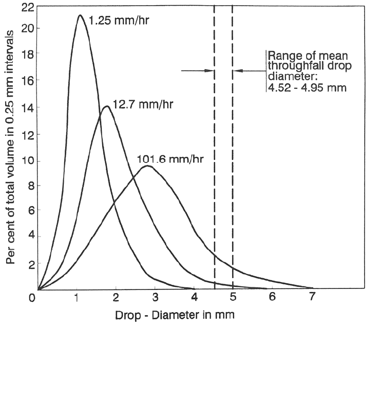
6.4.2 Rainfall
The energy imparted to the soil as a result of rainfall is dependent on drop size, fall
velocity, and rainfall intensity. Drop size increases as a function of rainfall intensity.
Defining the median drop diameter D
50
as the size in millimeters at which half the
volume of rainfall is contained in both larger and smaller drops, the median drop size can
he related to rainfall intensity by:
D
50
= 1.24 I
0.182
(6.1)
where I is the rainfall intensity in mm/h (Laws and Parsons, 1943). Representative
raindrop size distributions are illustrated in Fig. 6.5. A rainstorm will have only a few
drops significantly larger than the median, but many smaller drops. Based on the drop
size distribution determined by Laws and Parsons, and terminal drop velocities, an
equation for the rainfall energy as a function of intensity was developed by Wischmeier
EROSION 6.10
and Smith (1958) and was expressed in SI units by Foster et al. (1981). The kinetic
energy per unit of rainfall E
k
, in units of megajoules per hectare per millimeter of rainfall
(MJ/ha•mm), for rainfall intensity I (mm/h), is given by:
FIGURE 6.5 Size distribution of raindrops measured for three different rainfall intensities. (Lars
and Parsons, 1943), compared to the range of median drop size for canopy throughfall drops
beneath a leafy canopy (Brandi, 1990). The canopy tends to increase drop size for all but the most
intense rainstorms.
E
k
= 0.119 + 0.0873 log
10
I (6.2)
Multiply by 100 to express the results in J/m
2
•
h. Computations for three rainfall
intensities are summarized in Table 6.4, illustrating the dramatic increase in rainfall
energy as a function of intensity.
6.4.3 Rill Erosion
When flow becomes concentrated in rills the bed shear is capable of detaching soil
particles. Rills can grow, capture additional flow, and eventually grow into gullies. Like
larger channels, the sediment transported by rills includes both the material eroded by
channel processes plus the sediment delivered to the rills by interrill erosion.
EROSION 6.11
TABLE 6.4 Rainfall Characteristics
Intensity .
Type of
rainfall
in/h mm/h
Median drop
Diameter, mm
Kinetic energy, J/m
2
per mm per h
Drizzle 0.1 2.5 1.5 15.4 38
Heavy rain 1 25 2.2 24.1 602
Cloudburst 4 100 2.9 29.4 2940
6.4.4 Size of Eroded Particles
Particle size is an important parameter controlling the initiation and maintenance of
sediment transport and is used in some erosion-prediction models. Few soils behave as a
loose aggregation of grains, like sand on a beach. Rather, granules of many different sizes
form a matrix held together by chemical and organic bonding, especially when the soil
has a significant clay content.
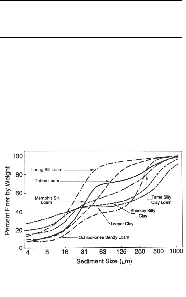
Meyer (1985) used simulated rainfall to analyze the relationship between the grain
size distribution of surface soil and eroded sediment for 17 soil types. Eroded sediment
tended to be enriched with respect to the clay content compared to the original surface
soil. Because of the formation of particle aggregates, an average of 46 weight-percent of
the two clay soils tested produced aggregate particles in the sand size (greater than 0.062
mm), whereas only 18 weight-percent of the eroded particles from eight silty loam
samples fell into the sand size. The large size of the eroded particles from clay soils as
compared to silty soils is illustrated in Fig. 6.6. The silty loams not only produced the
smallest particles of all soils tested, but were also the easiest to erode. This general
FIGURE 6.6 Size classification of eroded particles, showing that aggregation in cohesive
clay soils causes them to produce more coarse particles (larger than 63 m) than silty soils
(Meyer, 1985).
EROSION 6.12
pattern was confirmed by subsequent laboratory size testing of 21 soils from across the
United States (Rhoton and Meyer, 1987), where it was shown that simple laboratory
techniques for sizing bulk samples of surface soils, which eliminates the use of a
dispersant, can provide reasonable predictions of the size distribution of eroded particles.
6.5 GULLY EROSION
6.5.1 Gully Erosion Process
A gully is an erosional channel too large to he eliminated by normal cultivation
techniques or crossed by a wheeled vehicle, and active gullies are characterized by a
steep or vertical erosional scarp. Gully erosion occurs where erodible soil is exposed to
concentrated runoff from rainfall or snowmelt, and may be initiated by enlargement of a
rill, when flow is concentrated by a structure such as a trail, road, ditch or drain, or when
runoff is increased by upstream land use change. Roads intercept and concentrate
downslope flows and are prime agents in gully formation. Even off-road vehicles can
accelerate gully erosion, since they leave continuous imprints in the soil which
channelize overland flow during rainstorms, subsequently creating continuous rills and
gullies as opposed to the often short and discontinuous channels formed naturally and
which allow runoff energy to be dissipated (Heede, 1983). Although gullying is
commonly associated with disturbed lands in semiarid areas, extensive gullying can also
occur in humid areas when vegetation is removed.
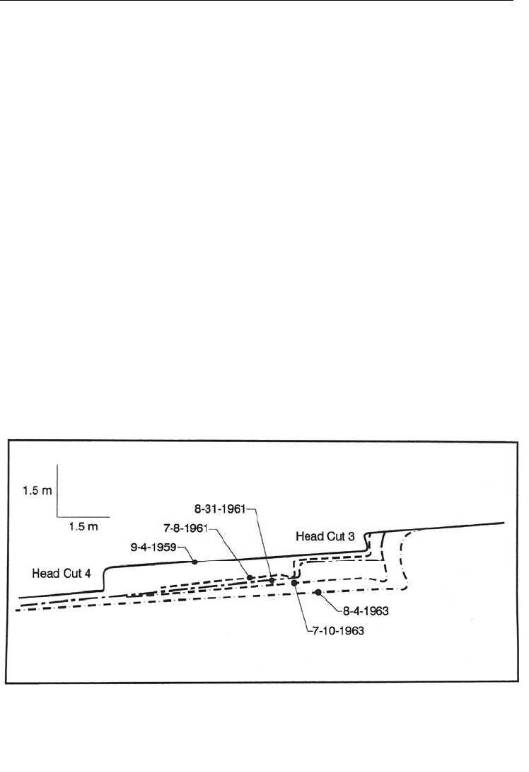
Water plunging into a gully over a vertical headwall creates a plunge pool and erodes
the foot of the headwall, causing it to collapse and move farther upstream, creating the
pattern of gully growth shown in Fig. 6.7. Additional nickpoints may erode upstream
along the gully floor, causing it to deepen. Headwall heights can range from a fraction to
many meters in height. Gullies typically become more mature and stable below the
actively eroding area of headcut. However, erosion can he reinitiated below the headcut if
the base elevation is lowered, causing the formation of new nickpoints and retrogressive
erosion upstream along the gully floor, deepening and widening the original gully.
Gullies may be discontinuous or may expand until an interconnected or continuous
channel network is formed, and their growth may be either regular or erratic.
Discharge and sediment concentration in gullies are not directly related,
FIGURE 6.7 Longitudinal profile of gully growth (Heede. 1975).
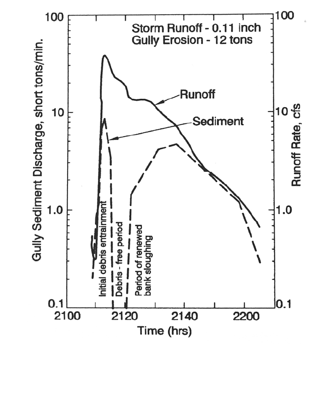
EROSION 6.13
demonstrating that processes in addition to hydraulic shear at the channel boundary
influence gully erosion rate. Four gullies in Iowa eroding loessial soils to an underlying
layer of more resistant glacial till were intensively monitored by Piest et al. (1975b) with
gaging stations above and below each gully to determine the variation in erosion rates
over time. The watersheds tributary to the gullies varied from 30 to 61 ha in size; two
were in conventional cropping sequences with corn and two were managed for
conservation. The two gullies below the conservation watersheds had stabilized as a
result of reduced rates of surface runoff and adequate channel vegetation. Sediment
discharge from the eroding gullies frequently peaked and then declined dramatically prior
to the peak discharge (Fig. 6.8). During some events the conventionally cropped
watersheds delivered more sediment than could be transported, causing sediment to
temporarily accumulate within the gully. From these and other observations it was
concluded that gully erosion is a two-stage process consisting of: (1) production of
sediment debris and (2) sediment transport. At the test site the debris production was
controlled primarily by block failure of gully walls, whereas transport was related to
hydraulic transport capacity. Other patterns of gully erosion may be important in other
geographic settings. For example, with an erodible channel floor, the rate of gully erosion
may be more closely related to channel hydraulics. Heede (1975) observed similar
irregularities in the rate of sediment export by gullies.
FIGURE 6.8 Rate of gully erosion determined by suspended sediment gaging upstream an
d
downstream of the gully reach, illustrating the dependence of gully erosion on two
processes: (1) production of erodible sediment debris and (2) hydraulic transport of debris
out of the gully (Piest et al.. 1975b)
EROSION 6.14
Schumm et al. (1988) concluded that all gullies follow essentially the same
evolutionary path with eventual development of relatively stable conditions, and outlined
four stages of gully evolution, presented below in a modified form.
Stage 1 Initiation. The channel gradually cuts through the upper (A and B) soil
horizons. This is the stage at which erosion control measures can most easily be
implemented.
Stage 2 Headcutting and deepening. This stage is characterized by upstream
migration of the headcut and plunge pool, caving of walls, and channel deepening
as the gully erodes weak underlying parent material. This stage ends when the
longitudinal channel profile becomes stabilized due to some type of base level
control, and the erosion rate declines.
Stage 3 Widening and healing. Widening of the gully top width occurs, slopes on
the gully walls are reduced by weathering and mass wasting, and revegetation
occurs.
Stage 4 Stabilization. The side slopes and base level stabilize and soils
accumulate and develop on older scarred surfaces. When the channel walls have
reclined to approximately 45° and have been vegetated, the gully can be
considered to be stable unless further disturbed.
These four stages may be applied to an entire gully system or to different reaches of a
single gully from head to mouth. Reversion to stage 2 conditions and renewed erosion
can occur during stages 3 or 4 because of lowering of the base level or upstream
disturbance.
6.5.2 Quantification of Gully Erosion
Gully growth tends to be both rapid and erratic, and both the growth rate and
configuration of gullies is highly dependent on local soil and hydrologic conditions.
There is no general method for predicting rates of gully formation and growth. All
estimates of gully erosion must be based on field measurements in the study area. Erosion
rate within a watershed may be approximated by using a time series of air photos to
determine the areal extent and growth rate of gullies, and number of gullies per unit area,
in combination with ground reconnaissance to determine wall heights. Gully erosion from
larger watersheds may be estimated as the sum of erosion rates prepared for smaller sub-
basins. In areas with few gullies, the sediment contribution by gully erosion may be small
enough to he ignored.
Regression equations have been developed to explain the rate of headwall advance in
individual gullies within specific regions. Watershed area tributary to the gully is the
single most important explanatory variable, and the rate of gully advance varies as
approximately the 0.5 power of tributary area. Based on studies in 210 gullies east of the
Rocky Mountains, the U.S. Department of Agriculture (1977) determined that at least six
factors significantly influenced the rate of headcut advance: tributary watershed area,
storm precipitation, soil erodibility, slope of approach channel above the headcut,
groundwater level, and changes in runoff due to land use changes above the gully. The
tributary watershed area and precipitation were found to best explain the rate of gully
headcut advance, according to the following relation:
R = 0.36 (A)
0.46
(P)
0.20
(6.3)
where R = rate of headward advancement, m/yr; A = tributary watershed area, ha; and P
= annual precipitation, mm, on days with precipitation in excess of 12.7 mm/day. This
relationship does not apply to arid regions with annual precipitation less than 500 mm.
EROSION 6.15
When the historical rate of gully advancement can he determined from field
measurements, interviews, or air photos, the future rate of headcut advancement can be
predicted by restating Eq. (6.3) on the basis of the principle of proportions as
R
f
/R
P
=(A
f
/A
p
)
0.46
(P
f
/ P
p
)
0.2
(6.4)
where the subscript f refers to future conditions and p to past conditions. For example, as
the gully headwall advances upstream, the tributary drainage area will decline. A gully
head moving up a small tributary will also have a smaller drainage area than the main
gully. Similarly, rainfall over a short historical period (less than 10 years) may have
differed significantly from the long-term average. The future rate of gully advance is
estimated from the historical period by substituting future and historical values, without
factors such as land use change and interception of different geologic material which will
affect the rate of gullying. The rate of headcut advancement will be decreased if erosion
carries the gully into more cohesive and erosion-resistant soils.
The total volume of material eroded by a gully will be influenced by the upstream
migration of secondary nickpoints and the widening of the gully floor, in addition to the
rate of headwall advance. Each of these should be considered separately. One method to
project future gully widening is to project headward advance, and assume that the top
width planform of the existing gully will move upstream with the headcut. Alternatively,
widening can be estimated from measurements in older nearby gullies to determine base
level gradient, depth, and topwidth:depth ratios. As a rule of thumb, in cohesive materials
gully topwidth is about 3 times gully depth and in noncohesive material gully topwidth is
about 1.75 times depth (Heede. 1976).
6.6 CHANNEL EROSION
6.6.1 Processes
Channel and streambank erosion occur along the bed and banks of streams. Actively
eroding banks are often nearly vertical with freshly exposed roots, and bank vegetation
generally offers no protection when bank undercutting occurs below the root zone.
Channel erosion is associated with the natural process of channel meandering as well as
accelerated erosion due to channel incision and widening. The downstream impacts
associated with these processes are quite distinct.
Alluvial rivers continuously meander across their floodplain, scouring sediment from
the outer side of one meander bend and depositing a portion of this load on point bars
farther downstream, while maintaining the same channel width and longitudinal profile.
The process of meander migration documented by Leopold et al. (1964) in Fig. 6.9
illustrates that the river width and thalweg depth remain essentially constant, and that the
point bar fills hack to the level of the original floodplain. Sediment eroded from
FIGURE 6.9 Process of meander migration (modified from Leopold et al., 1964).
EROSION 6.16
meanders is not necessarily exported, since it may be redeposited a short distance
downstream. During floods a meandering river reach can become a net depositional
environment because of floodplain sedimentation. The rate of channel bank erosion is not
indicative of net sediment yield unless accompanied by channel widening or incision.
Much of the channel bank protection activity throughout the world has been directed at
stabilizing meandering rivers to improve navigation and protect properties in erosion-
prone areas. This converts naturally meandering streams into fixed streams controlled by
hard structures such as revetments and dikes. The Rhine is an example of a highly
regulated river which has been confined to a fixed channel by erosion control structures
along either side, and can now erode only vertically.
Degradation and incision of streambeds cause channel widening and the net export of
potentially large volumes of sediment because of hydraulic forces which erode and
transport sediment, plus bank failures initiated by undercutting. Channel incision can be
initiated or accelerated by increased peak flows caused by upstream land use changes,
deeper flow due to diking or levee construction, reduced supply of bed material due to
trapping in upstream reservoirs, reduction in hydraulic roughness and increase in channel
slope due to stream channelization and straightening, removal of streambank vegetation
and mechanical breakdown of banks by livestock, and in-stream mining of sand and
gravel. A period of channel erosion can also follow a period of channel deposition during
a period of increased sediment supply. Examples of channel incision and erosion are
described in Chap. 22, the Feather River case study.
The process of channel incision is quite distinct from meander migration: it involves
both a lowering of base level and the incision of a new wide floodplain within the older
deposits. This erosion process can remove large volumes of valley sediment until a new
meandering channel within an entrenched floodplain becomes stabilized at a lower base
level (Fig. 6.10). A classic example of channel degradation and massive sediment export
is the Rio Puerco, summarized by Schumm et al. (1988). Rio Puerco drains a 19,000-km
2
watershed in north and central New Mexico and is a major sediment source affecting
Elephant Butte reservoir on the Rio Grande. A sediment concentration of 327,000 ppm in
Rio Puerco, 40 percent of which was sand, was documented by Nordin (1963) at a
discharge of 30 m
3
/s. From historical records and photographs, it is known that prior to
1885 Rio Puerco and its tributary channels were small and the valley was apparently
stable with a few discontinuous gullies. A combination of climatic and human impacts,
which are not well understood, triggered the process of channel incision which resulted in
the net erosion of 48.7 Mm
3
of sediment from the channel between 1887 and 1928. After
initial deepening the channel migrated laterally and meandered, creating a widening
floodplain entrenched within the former floodplain.
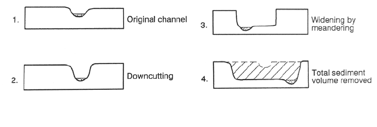
6.6.2 Quantifying Channel Erosion
Sediment volumes removed by channel erosion may be computed from the change in
channel geometry over time as recorded by repeated aerial photography or field
measurements of bank height (or river profile) and the width of the eroded area consisting
FIGURE 6.10 Conceptual process of channel incision and widening.