Morris & Fan. Reservoir Sedimentation Handbook
Подождите немного. Документ загружается.

SEDIMENT YIELD FROM WATERSHEDS 7.41

SEDIMENT YIELD FROM WATERSHEDS 7.42
erosion whereas the delivery of deeper soils or parent material can indicate channel
erosion sources.
Properties used for fingerprinting include clay mineralogy, sediment color, sediment
chemistry, mineral magnetic properties, and radionuclide concentrations. The three
radionuclides with the greatest promise for use as indicators are the artificial isotope
137
cesium, and atmospherically derived (i.e., nonnatural or "unsupported")
210
1ead and
7
beryllium isotopes. All are gamma emitters with different fallout histories and decay
rates and have been dispersed at relatively uniform rates over wide geographic areas. On
all, simultaneous nondestructive activity measurements can be made relatively easily by
modern high-resolution gamma spectrometry equipment. Because fallout rate is unrelated
to parent soil material, radionuclide concentration can be used to differentiate between
sediment sources in basins of otherwise homogeneous soils. Fingerprinting techniques
using radionuclides are described by Walling and Woodward (1992).
Fingerprinting techniques were used by Peart and Walling (1986) to analyze sediment
sources in the small 9.3-km
2
Jackmoor Brook watershed in the United Kingdom with
multiple tracers: pyrophosphate iron, dithionite iron, manganese oxide, magnetic
susceptibility, saturation isothermal remanent magnetization (SIRM), total P, total N,
organic carbon, and
137
cesium. Over 100 samples of surface and streambank soils were
collected and the fines (d < 0.06 mm) were separated and analyzed. Suspended sediment
from multiple runoff events was also collected from the stream by pumped sampler,
centrifuged, and analyzed. The values of all tracer parameters except one were higher in
the suspended sediment compared to the soil samples because of enrichment in the fine
fraction. Particle size analysis determined that enrichment was primarily restricted to the
smaller than 0.010 mm fraction. The enrichment factor for this size fraction was about
1.5 for both channel and surface material but was higher for organic material. Following
correction for enrichment, the relative contribution of surface and bank material to the
composite suspended load was determined by using a simple mixing model:
100
bs
br
s
PP
PP
C
(7.8)
where C
s
= percent contribution from surface soil sources, P
r
= value of selected property
for suspended sediment, P
s
= value of selected property for surficial soil, and P
b
= value
of selected property for bank material.
To check the error introduced by enrichment calculations, property ratios were also
analyzed (e.g., carbon/phosphorus). If property ratios from each source are consistent
across all size fractions, this eliminates the need to correct for enrichment computations.
The enrichment computations were generally confirmed.
By further subdividing the soil sample dataset into cropland and permanent pasture, it
was possible to differentiate between these two sources of surface sediment based on
137
cesium activity. Radioactive cesium is tightly sorbed at the soil surface and penetrates
insignificantly into deeper soil layers. Thus, the highest levels of activity corresponded to
topsoil in permanent pasture which had been continuously exposed to fallout,
intermediate levels of activity occurred in arable soils mixed by ploughing, and the
lowest levels were in the deep deposits along channel banks. On the basis of
fingerprinting it was concluded that suspended sediments at the gage station were derived
from the following sources: 6 percent from channel banks, 24 percent from permanent
pasture topsoil, and 70 percent from arable topsoil.
Fingerprinting can potentially be applied to sediments deposited in reservoirs.
However, the reconstruction of stratigraphic histories and application of source tracing or
fingerprinting techniques to reservoir sediment profiles is complicated by the high
variability in sediment deposition patterns. Foster and Charlesworth (1994) analyzed core
data from four small (less than 7-ha pool area) artificial impoundments in the United

SEDIMENT YIELD FROM WATERSHEDS 7.43
Kingdom and found that the spatial variability is often greater than downcore variability.
The problem of spatial heterogeneity in reservoir sediments due to longitudinal sorting,
variable pool level, reworking of sediments, and sediment focusing by density currents
must be carefully analyzed in any stratigraphic or source-tracing analysis of deposits.
Under conditions where it is applicable, fingerprinting offers the means to directly
determine sediment delivery by source. However, use of this method is complicated by
phenomena including enrichment with fines and organics as a result of differential rates
of transport, sediment transformations during transport which alter nonconservative
sediment characteristics, and the temporary storage and remobilization of sediment
within the fluvial system. This makes fingerprinting more applicable to watersheds with
rapid sediment export and small amounts of sediment storage in streams. Fingerprinting
cannot be employed if sediment tracer characteristics are relatively uniform throughout
the basin. However, even when soils are uniform across a watershed, it may be possible
to distinguish among erosional sources on the basis of differences in radionuclide
deposition. At present, fingerprinting is primarily a research tool.
7.8.5 Lake and Reservoir Deposit Histories
Sediment deposits in impoundments may be cored and characteristics of the core material
may be interpreted to provide information on the processes responsible for sediment
delivery from the watershed. For example, Hereford (1987) examined the depositional
history of a small reservoir at the outlet of a 2.8-km
2
high-relief basin in Utah, and from
stratigraphic analysis of the alluvium determined that significant sediment deposition
occurred in the reservoir only 21 times in 38 years. From the thickness of the deposits,
the average sediment load of individual events was determined as 2300 m
3
/km
2
with a
standard deviation of 1300 m
3
/km
2
. The variation in sediment yield between events was
slightly less than 1 order of magnitude. That this variation was considerably lower than
the 3 orders of magnitude variation in annual sediment yield typical of the region
suggested that sediment supply was limited by erosion rates on hill slopes rather than
transport processes. In landscapes characterized by large episodic sediment yield events,
the analysis of natural lake cores may help estimate the frequency of these large events,
which may leave a thick layer of coarse sediment or other identifiable and datable
features in the lacustrine sediment record. Laronne (1990) describes the use of
stratigraphy in small artificial impoundments to determine the recurrence interval of
sediment discharge events in the semiarid northern Negev, Israel. They suggest that the
availability of event-based sediment yield records may be utilized to predict erosion rates
without recourse to rainfall or runoff data.
7.9 CLOSURE
Sediment yields are highly variable, and most of the sediment entering a reservoir is
delivered from only a small fraction of the landscape during short periods of time. The
key to effective sediment management, either in the watershed or at the reservoir, lies in
identifying and characterizing both the spatial and timewise nature of sediment delivery.
This, in turn, will permit control efforts to be focused effectively, and for sustainable use
to be achieved.
Fluvial sediment yield is among the most difficult parameters to accurately measure
in the field, but accurate measurements are essential to provide the data required to better
understand delivery processes, and to support sediment modeling efforts. Due to the
highly variable rates of sediment delivery, the results of erosion modeling are not
necessarily representative of the sources of sediment actually reaching a reservoir, unless
SEDIMENT YIELD FROM WATERSHEDS 7.44
they can he calibrated with field data. Modern fluvial sampling techniques using portable,
microprocessor-driven automatic sampling equipment incorporating stage recorders,
turbidimeters, and pumped samplers, can be particularly useful for fluvial sampling.
Techniques for sediment sampling are outlined in Chap. 8.

CHAPTER 8
FLUVIAL MORPHOLOGY AND SEDIMENT
SAMPLING
The quantification of sediment load is fraught with difficulty and the potential sources of
error are numerous because of vertical and horizontal variability in sediment transport
within the river section, extreme and potentially rapid variation in sediment transport
over time, poor correlation of sediment concentration with other hydrologic variables,
and logistical problems associated with sampling during flood and hurricane. A basic
understanding of fluvial sediment variability in time and space, sampling techniques,
bias, and possible sources of error is essential to properly collect and interpret sediment
data. This chapter introduces several basic concepts of river morphology, focusing on
patterns of sediment variation within the fluvial environment. Sampling techniques for
both suspended load, bed load, and bed material are presented, and some of the sources of
error that can affect sampling programs are discussed.
8.1 STREAM FORM AND CLASSIFICATION
River morphology is a complex topic, and this section provides only a brief summary of
several fundamental concepts which are important from the standpoint of understanding
sampling strategies. General concepts are presented by Guy (1970) and a quantitative
overview of river morphology from the aspect of fluvial engineering is presented in
Chang (1988).
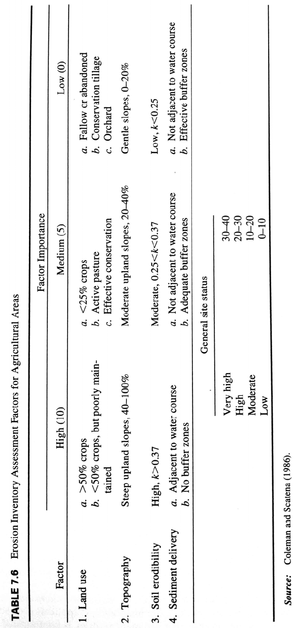
8.1.1 Stream Order
Stream order is a measure of the position of a stream in the hierarchy of tributaries. In
1932, Horton introduced to U.S. practice a stream-ordering system in which the lowest
order was assigned to the smallest stream, the reverse of the European practice which
assigned the lowest order to the largest rivers. In the Horton method a first-order stream
has no tributaries at the mapping scale being used in the analysis, and second-order
streams have only first-order tributaries. Third-order streams have only first- and second-
order tributaries, etc. This system extends downstream including higher-order streams
until reaching the study limit or the sea. In the Strahler method all intermittent streams at
the upstream limit of the drainage system are first-order, the confluence of two first-order
streams creates a second-order stream, etc. This method may be considered less
subjective than Horton's and is widely used. Both methods are illustrated in Fig. 8.1.
FLUVIAL MORPHOLOGY AND SEDIMENT SAMPLING 8.2
FIGURE 8.1 Stream-ordering methods proposed by Horton and Strahler. Other ordering
schemes are also in use (after Gordon et al., 1992).
Other ordering systems also exist (Gordon et al., 1992). Stream lengths and orders are
commonly determined by using topographic mapping at 1:24,000 or similar scale, and
stream order determination depends on the mapping scale since smaller tributaries appear
at larger map scales. At a scale of 1:62,000 the Mississippi River is of tenth order. Many
low-order streams discharge directly into streams two or more orders higher, and building
a dam on every third-order stream in a fifth-order network will typically control only
about half of the total drainage area. For this reason, schemes to build either sediment or
flood retention dams on smaller streams require a large number of structures (Leopold et
al., 1964).
8.1.2 Drainage Density
Drainage density is the total length of streams per unit area within a watershed. Because
much eroded sediment is redeposited prior to reaching channels, basins with a high
drainage density tend to export sediment efficiently. Drainage density comparisons must
be made on the same mapping scale, since greater enlargement reveals smaller tributaries
and produces longer total stream lengths. Topographic maps at 1:24,000 or similar scale
are generally used for this computation.
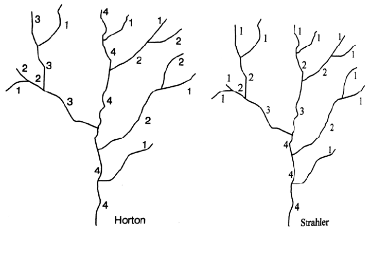
5.1.1. 8.1.3 Stream Patterns
Stream patterns reflect geology, sediment load, discharge, and slope. In erodible
materials, the stream planform is controlled largely by sediment load and hydraulic
forces, modified by erosion-resistant features on the bed and banks such as bedrock
outcrops, clay lenses, or similar features that influence both the meander pattern and
migration rate. The classification of basic channel patterns is summarized in Fig. 8.2.
Stream sinuosity is computed as the channel length divided by the straight-line valley
length, which may also be expressed as valley slope divided by channel slope. A stream
is classified as meandering if sinuosity exceeds 1.5.
FLUVIAL MORPHOLOGY AND SEDIMENT SAMPLING 8.3
FIGURE 8.2 Basic river planforms and sinuosity S. Straight channels occur only when structural
controls are present.
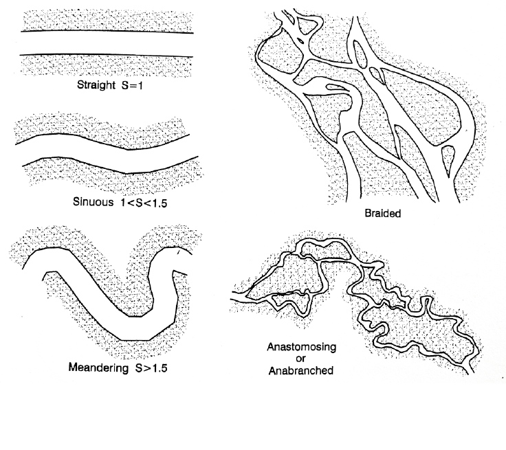
8.1.4 Meandering and Stream Migration
Rivers are rarely straight for significant distances, except when constrained by structural
controls. Even in laboratory flumes containing uniformly graded material it is impossible
to maintain a straight channel; flow irregularities cause differential rates of erosion and
initiate meander formation. Stream meandering patterns and bar location are illustrated in
Fig. 8.3. Erosive forces are focused on the exterior of bends slightly downstream of the
center of curvature. The bed and bank are scoured on the outside of the bend, helical flow
patterns are created, and the thalweg (the deepest flow line) occupies the exterior of the
bend, as shown in section B-B’ of the figure.
The interior of bends is a lower-velocity depositional environment characterized by
the formation of a point bar which infills behind the migrating meander bend. Pioneer
vegetation adapted to depositional environments colonizes the point bar and retards the
flow velocity as it crosses the bar, encouraging the deposition of increasingly finer-
grained material. Erosion at the meander exterior and deposition on the point bar causes
meanders to migrate both laterally and downstream. Erosion from the bend exterior is
balanced by deposition on the point bar, and the river maintains a constant width as it
migrates across the floodplain. Bank erosion and migration rates are greatly accelerated
during periods of high flow. When lateral migration brings two meanders into proximity,
causing a meander to cut off, it creates an oxbow lake which will eventually fill with
sediment from future floods.
The thalweg moves from one side of a river to the other as meanders turn in alternate
directions. The zone of thalweg crossing between bends typically has a flatter and
FLUVIAL MORPHOLOGY AND SEDIMENT SAMPLING 8.4
shallower cross section, compared to the meanders, and an unstable thalweg location. As
a result, the thalweg profile along a meandering river will be irregular, characterized by
deeper water at bends and shallower water at crossings. This same type of irregularity can
occur in the thalweg profile of reservoirs having curved reaches and sufficient sediment
accumulation for deposits to be affected by scour. An example of such a thalweg profile
in Loiza reservoir is presented in Fig. 20.9, where a scour hole has developed in the fine
sediment at a sharp curve near km 5.5.
FIGURE 8.3 Reach of the meandering sand-bed Rio Maniqui in the upper Amazon drainage in
Bolivia, showing the main types of bars, direction of meander migration, and the variation in
channel cross section between meander bends and crossings. The bed consists primarily of
medium to coarse sands, but clay lenses create erosion-resistant areas on the bed and banks
which influence the rate and pattern of river migration (after Morris and Ancalle, 1994).
FLUVIAL MORPHOLOGY AND SEDIMENT SAMPLING 8.5
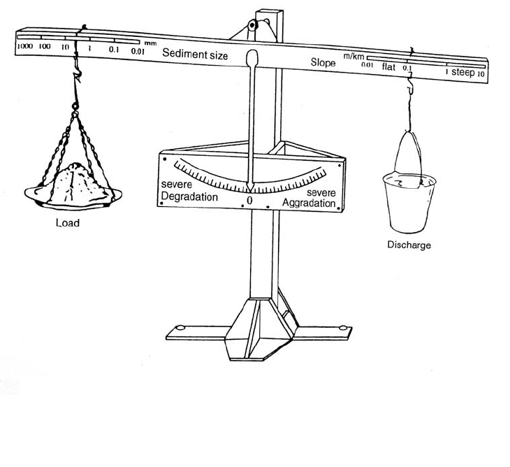
8.1.5 Lane's Balance
Alluvial rivers are dynamic systems, continually adjusting to the unsteady hydrologic
environment, and river form can change dramatically when certain hydraulic thresholds
are crossed. A qualitative geomorphic relationship among the major variables affecting
river form was proposed by Lane (1955) in the form of an equilibrium equation:
Q
s
d Q S (8.1)
where Q
S
and Q refer to sediment and water discharge respectively, d to grain diameter,
and S to bed slope. This equation may also be visualized in the form of the balance shown
in Fig. 8.4. According to this relationship, dam construction which affects a downstream
river reach by reducing sediment supply or reducing sediment size can be expected to
produce downstream degradation since all of these actions tend to reduce the slope
required to maintain equilibrium. In contrast, the reduction in total or peak discharge
which typically occurs below the dam, tends to increase the equilibrium slope. Thus,
reduced sediment discharge is, to a certain extent, balanced by reduced water discharge.
The interplay among these and other factors (armoring, tributary inflows, encroachment
by vegetation) will determine the extent and speed of channel adjustment below the dam.
Generally, an aggrading channel tends to widen and a degrading channel tends to narrow.
Quantitative geomorphic relationships which are an extension of Lane's qualitative
approach have been presented by Chang (1988), Yang (1996), and Klaassen (1995).
SedimentloadxSedimentsizeStreamslopexDischarge
Figure 8.4 Visualization of the factors influencing the geomorphic behavior of an alluvial
stream (Lane, 1955)
FLUVIAL MORPHOLOGY AND SEDIMENT SAMPLING 8.6
8.1.6 Differences between Sand and Gravel Bed Streams
The grain size in movable bed rivers can range from silts to boulders. For convenience,
the continuum of bed material sizes will be divided into sand-bed and gravel-bed rivers,
understanding that sand bed also includes smaller noncohesive sediment, and gravel bed
includes coarser material. To exhibit all the characteristics of a sand-bed river, the depth
of sand deposits in the bed must exceed the maximum scour depth so that additional sand
is continuously available for transport at all discharges. Several important differences
between sand-bed and gravel-bed rivers are summarized in Table 8.1.
TABLE 8.1 Selected Differences between Rivers with Sand and Gravel Bed.
Param
eter Sand bed Gravel bed
Grain size variation in the bed Small Large
Bed material transport Continuous Episodic
Channel slope (Velocity)
5
(Velocity)3
Variation in sediment transport Low High
Armoring Ineffective Significant
Bed forms Present Absent
Variation in scour depth Rapid Slow
Scour depth Deep Shallow
Channel response to changed hydrology Rapid Slow
Source: Modified from Simons and Simons (1987).
Movable beds of sand-size material typically have a relatively narrow range of grain
sizes. Small amounts of sand are being transported continuously, even at low discharges,
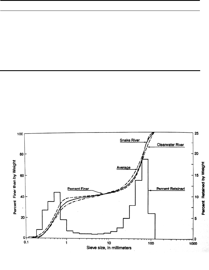
and armoring is absent. In contrast, gravel beds may contain grain sizes ranging from
sand to cobbles, frequently exhibit bimodal grain size distribution curves (Fig. 8.5), and
Figure 8.5 Bimodal grain size distribution for gravel-
b
ed rivers showing grain size as both
a histogram and a cumulative frequency distribution (Emmett, 1976)