Middleton G.V. (Ed.) Encyclopedia of Sediments and Sedimentary Rocks
Подождите немного. Документ загружается.

MUDROCKS 455
cross-lamination provides useful insights to the paleocurrent
pattern of ancient shaly basins, which ean also be estimated
from oriented wood, graptolites, ostracodes, and some
elongate foraminifers. It is always good to remember that
bottotn currents exist in both oxygenated and poorly
oxygenated basins, although in mudroeks. thin sections, and
polished sections may be needed to sec micro cross-lamination
and flutes best. Current systems in ancient muddy basins have
also,
in a few instances, been inferred from their pattern of silt
deposition (Jones and Blatt, 1984),
In sum, little is more important in the study of mudroeks
than their sedimentary structures, especially when combined
with examination of body and trace fossils. Sedimentary
structures help us identify types of bottom currents such as
distal turbidity currents, contour currents or hemipelagic rains
of fine terrigenous debris. Relatitig abrupt vertical changes in
the sequence of structures in a mudrock with the presenee of
weak discontinuities, changes in fossil assemblages, pyrite, or
phosphate, clay content and color is the basis for recognizing
the basin-center equivalents of major stratigraphie breaks that
are eommon along basin margins.
Oxygen
The presence or absence of dissolved oxygen in bottom waters
and in the first lew decimeters of muddy bottoms is all
important for the color, degree of bioturbation and abundance
of oxygen sensitive minerals such as pyrite and siderite and
organic matter (kerogen). The concept of stratification of the
water colutnn is needed here. The water of a lake or sea is
described as
.\iralificil.
uhen not uniformly mixed. This may be
the result ol' temperature, density, or oxygen differences.
Mudroeks are the best indicators of stratification of the water
column in ancient basins.
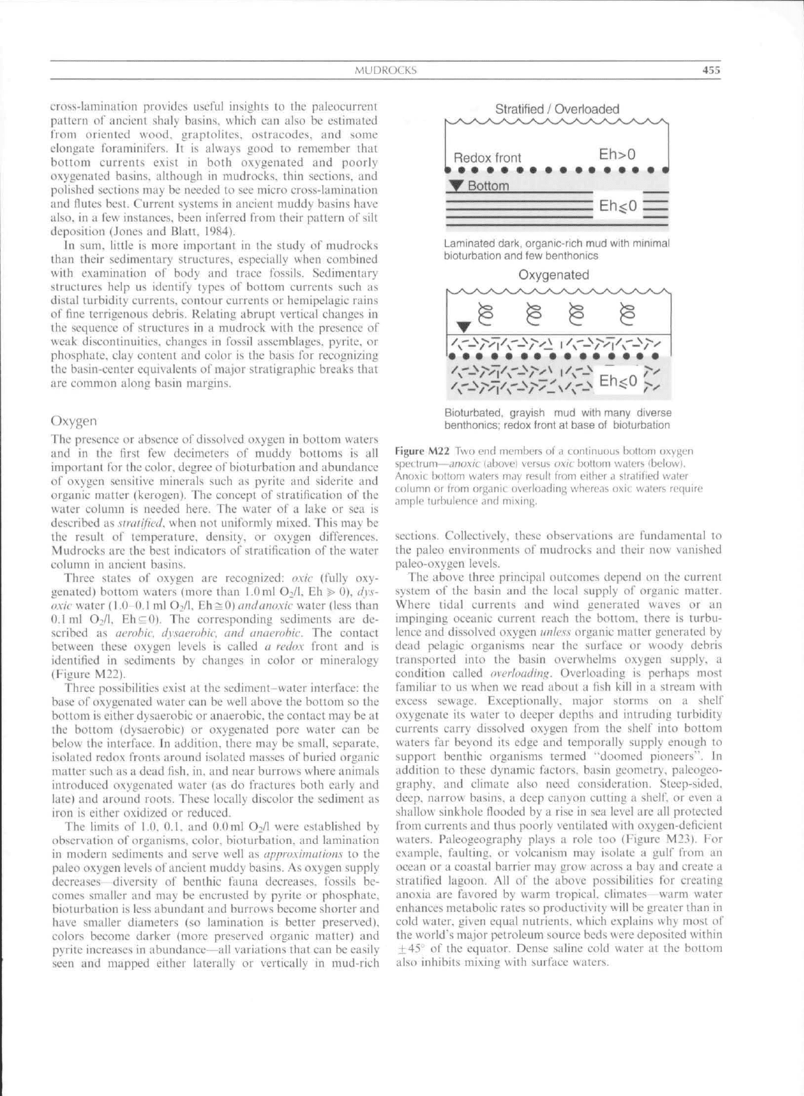
Three states of oxygen are recognized: oxic (fully oxy-
genated) bottom waters (more than 1.0 ml Oi/I. Eh
t>
0), </v,v-
oxic water (1.0-0.1 ml O^/l. Eh^O) amiauoxic water (less than
0,1 tnl O2/I. Eh^O). The eorresponding sediments are de-
scribed as aerobic, tlysacrohic. ami anaerobic. The contact
betueen these oxygen levels is called a rvdox front and is
identified in sediments by changes in color or mineralogy
(Figure M22).
Three possibilities exist at the scdimcnt-water interface: the
base of oxygenated water can be well above the bottom so the
bottom is either dysaerobic or anaerobic, the contact may be at
the bottom (dysaerobic) or oxygenated pore water can be
below the interface. In addition, there may be small, separate,
isolated redox fronts around isolated masses of buried organie
tnatter such as a dead fish, in. and near burrows where animals
introduced oxygenated water (as do fractures both early and
late) and around roots. These locally discolor the sediment as
iron is either oxidized or reduced.
The limits of 1.0. 0,1. and 0.0 ml OVl were established by
observation of organisms, color, bioturbation. and lamination
in modern sediments and serve well as approxiiuaiion.s lo the
paleo oxygen levels of ancient muddy basins. As oxygen supply
decreases diversity o\' benthic faunit decreases, fossils be-
comes smaller and may be enerusted by pyrite tir phosphate,
bioturbation is less abundant and burrows beeome shorter and
have smaller diameters (so lamination is better preserved),
colors become darker (more preserved organic matter) and
pyrite increases in abundance—all variations that ean be easily
seen and mitpped either laterally or vertically in mud-rich
Stratified / Overloaded
Redox front
Eh>0
Bottom
Eh<0
Laminated dark, organic-rich mud with minimal
bioturbation and few benthonics
Oxygenated
Bioturbated, grayisb mud with many diverse
benthonics; redox front at base of bioturbation
Figure M22 Two end members of a continuous bottom oxygen
spt'( trum—cinoxic (abovei versus oxic bottom waters (below].
Anoxic bnltom waters may result Irom either
,1
stratified water
column or from organic overbading whereas oxic waters require
ample turbulence and
seetions. Collectively, these observations are fundamental to
the paleo environtnents of mitdrocks and iheir now vanished
paleo-oxygen levels.
The above three principal outcomes depend on the current
system of the basin and the local supply of organic matter.
Where tidal currents and wind generated waves or an
impinging oceanic current reach the bottom, there is turbu-
lence and dissolved oxygen
unlcs.s
organic matter generated by
dead pelagic organisms near the surface or woody debris
transported into the basin overwhelms oxygen supply, a
condition ealled tivcrhnuiini^. Overloading is perhaps most
familiar to us when we read about a lish kill in a stream with
excess sewage. Exceptionally, major storms on a shelf
oxygenate its water to deeper depths and intruding turbidity
currents carry dissolved oxygen from the shelf into bottom
waters far beyond its edge and temporiilly supply enough to
support benthic organisms termed "doomed pioneers". In
addition to these dynatnic factors, basin geometry, paleogeo-
graphy, and climate also need consideration. Steep-sided,
deep,
narrow basins, a deep canyon cutting a
shelf,
or even a
shallow sinkhole flooded by a rise in sea level are all protected
from currents and thus poorly ventilated with oxygen-deficient
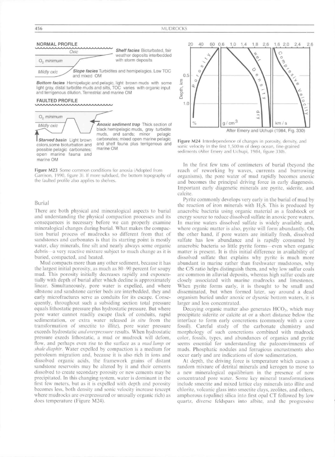
waters. Paleogeography plays a role too (Figure M23), For
example, faulting, or voleanism may isolate a guif from an
ocean or a coastal barrier may grow across a bay and create a
stratified lagoon. All o\ the above possibilities for creating
anoxia are favored by warm tropical, climates warm water
enhances metabolic rates so produetivity will be greater than in
cold water, given equal nutrients, which explains v\hy most o\'
the world's major petroleum source beds were deposited within
+
45"
of the equator. Dense saline cold water at the bottom
also inhibits mixing with surface waters.
456
MUDROCKS
NORMAL PROFILE
Oxic
20 40 60 0.6 1.0 1.4 1 2.6 1.6 2-0 2.4 2.6
O,
minimum
Shelf facies
Bioturbated. fair
weather deposits interbedded
with storm deposits
Mildly oxic
y^
Slope facies
Turbidites and hemipeiagics. Low TOC
— and mixed OM
Bottom facies
Hemipelagic and pelagic, light brown muds with some
light gray, distal turijidite muds and silts, TOC varies with organic input
and terrigenous
dilution.
Terrestrial and marine OM
FAULTED PROFILE
O,
minimum
I
Starved basin
Light brown
colors.some bioturbation and
possible pelagic carbonates;
open marine fauna and
marine OM
Anoxic sediment trap
Thick section of
black hemipeiagic muds, gray turbidite
muds,
and sands; minor peiagic
carbonates; mixed open marine pelagic
and shelf fauna plus terrigenous and
marine OM
Figure M23 Some common conditions for anoxia (Adopted from
Cirrison,
1990, figure 3). If more subtlued, the bottom topography of
the faulted profile also applies to shelves.
Burial
There arc both physical and mineralogical aspects to burial
and understanding the physical compaction proccs.ses and its
consequences is necessary bclbrc we can properly examine
mineralogical changes during burial. What makes the compac-
tion burial process of mudrocks so different from that of
sandstones and carbonates is that its starting point is mostly
water, elay minerals, tine silt and nearly always some organic
debris—a very reactive mixture subject to much change as it is
buried, compacted, and heated.
Mud compacts tnore than any other sediment, because it has
the largest initial porosity, as much as 80 90 percent t^or soupy
mud. This porosity initially deereases rapidly and exponen-
tially with depth of burial after which decline is approximately
linear. Simultaneously, pore water is expelled, and where
siltsione and sandstone carrier beds are interbedded, they and
early micro fractures serve as conduits for its escape. Conse-
quently, throughout such a subsiding section total pressure
equals lithostatic pressure plus hydrostatic pressure. But where
pore water cannot readily escape (lack of conduits, rapid
sedimentation, or extra water released In silii from the
transformation of smeetite to illite), pore water pressure
exceeds hydrostatic anilovcrprcssiin' results. When hydrostatic
pressure exeeds lithostatic a mud or mudrock will defom.
flow, and perhaps even rise to the surfaee as a mud lump or
shale diaphir. Water expelled by compaetion is a medium for
petroleum migration and. beeause it is also rich in ions and
dissolved organie acids, the framework grains of distant
sandstone reservoirs may be altered by it and their cements
dissolved to create seeondary porosity or new cements may be
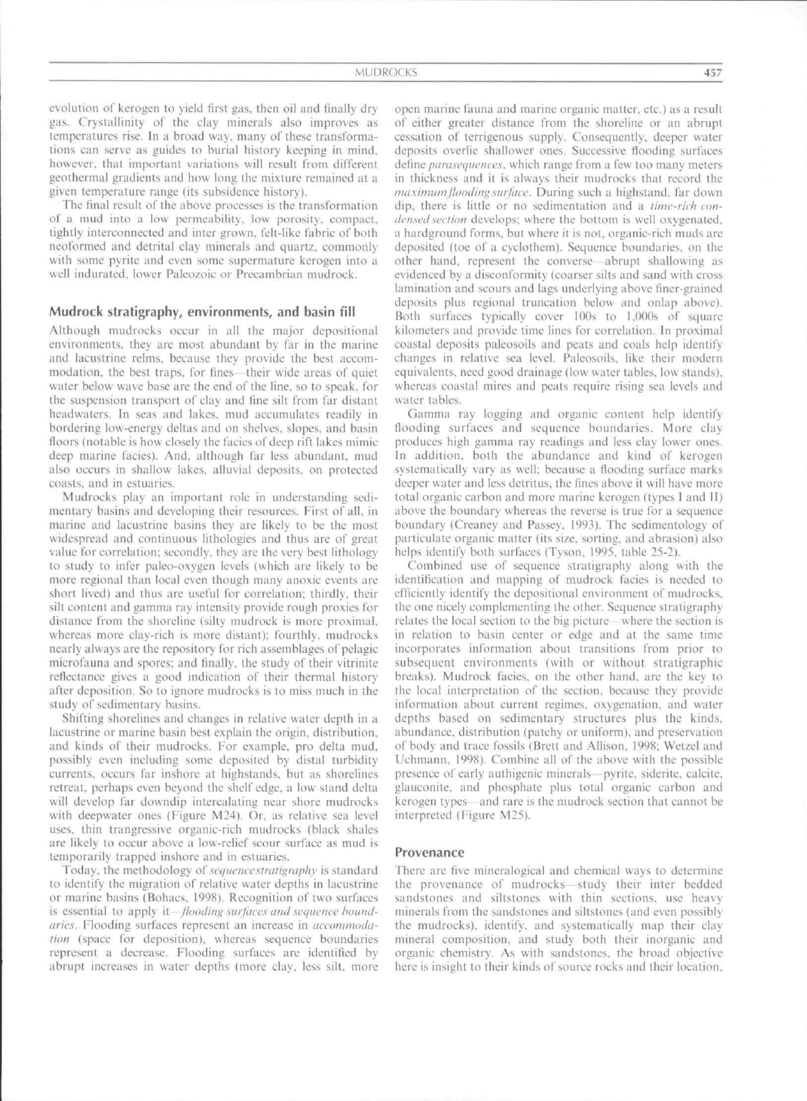
precipitated. In this changing system, walei" is dominant in the
first few meters, but as it is expelled with depth and porosity
becomes less, both density and sonic velocity increase {except
where mudroeks are overpressured or unusaliy organic rich) as
does temperature (Figure M24).
0.5
1.0
o /
g/cm^
1 1
Vo
km/s 1
After Emery and Uehupi (1984, Fig. 330)
Figure M24 Interdependence of changes in porosity, density, and
sonit. velocity in the first l,5()0m of deep ocean, fine-grained
sediments (After Emery and Uthupi, 1984. figure .330).
In the first few tens of centimeters of burial (beyond the
reaeh of reworking by waves, currents and burrowing
organisms), the pore water of mud rapidly becomes anoxic
and becomes the principal driving force in early diagenesis.
Important early diagenetic minerals are pyrite, siderite, and
calcite.
Pyrite commonly develops very early in the burial of mud by
the reaction of iron minerals with H2S. This is produced by
anaerobie bacteria using organic material as a feedstock or
energy source to reduce dissolved sulfate in anoxic pore waters.
In marine waters dissolved sulfate is widely available and.
where organie matter is also, pyrite will form abundantly. On
the other hand, if pore waters are initially tVesh. dissolved
sulfate has low abundance and is rapidly consumed by
anaerobic bacteria so little pyrite forms even when organic
matter is present. It is this initial difference in availability of
dissolved sulfate that explains why pyrite is much more
abundant in marine rather than freshwater mudstones, why
the C/S ratio helps distinguish them, and why low sulfur eoals
are common in alluvial deposits, whereas high sulfur coals are
closely associated with marine mudrocks and limestones.
When pyrite forms early, it is thought to be small and
disseminated, but when formed later, say around a dead
organism buried under anoxic or dysoxic bottom waters, it is
larger and less concentrated.
Decaying organic matter also generates HCO3, which may
precipitate siderite or calcite at or a short distance below the
interface to form early eoncretions (commonly with a core
fossil).
Careful study of the earbonate chemistry and
morphology of such eoncretions combined with mudrock
color, fossils, types, and abundances of organics and pyrite
seems essential for understanding the palcoenvimnents of
muds.
Phosphatie nodules and ferrugious encrustments also
oeeur early and are indications of slow sedimentation.
Af depth, the driving force is temperature which causes a
random mixture of detrital minerals and kcrogen to move to
a new mineralogical equilibrium in the presenee of now
concentrated pore water. Some key mineral transformations
include smectite and mixed lattiee clay minerals into illite and
chlorite, volcanic glass into smeetite elays. zeolites, and others,
amphorous (opaline) silica into first opal CT followed by low
quartz, diverse feldspars into albite. and the progressive
MUDROCKS
457
evolution of kerogen to yield first gas. then oil and finally dry
gas.
Crystallinily of the clay minerals also improves as
temperatures rise. In a broad way. many of these transforma-
tions can serve as guides to burial history keeping in
mind,
however, that important variations will result iVom dilTcrcnt
geolhermal gradients and how long the mixture remained at a
gi\en temperature range (its subsidence history).
The final result of the above processes is the transformation
oi a mud into a low permeability, low porosity, compact.
tightl> interconnected and inter grown, felt-like fabric of both
neoformed and detrital clay minerals and quartz, commonly
with some pyrite and even some supermature kerogen into a
uell indurated, lower Paleozoic or PreeanibrJan mudrock.
Mudrock
stratigraphy,
environments,
and
basin fill
Although mudrocks occur in all the major depositional
environments, they are most abundant by far in the marine
and lacustrine reims, because they provide the best accom-
modaiion,
the best traps, for fines—their wide areas of quiet
uater below wave base are the end of the line, so to speak, for
the suspension transport of elay and fine silt from far distant
headwaters. In seas and lakes, mud accumulates readily in
bordering low-energy deltas and on shelves, slopes, and basin
floors (notable is how closely the facies of
deep
rift lakes mimic
deep marine facies). And. although far less abundant, mud
also occurs in shallow lakes, alluvial deposits, on protected
coasts,
and in estuaries.
Mudrocks play an important role in understanding
sedi-
mentary basins and developing their resourees. First of all. in
marine and laeustrine basins they are likely to be the most
widespread and continuous lilhologies and thus are of great
value for correlation: secondly, they are the very best tithology
to sUidy lo infer paleo-oxygen levels (which are likely to be
more regional than local even though many anoxic events are
short lived) and thus are useful for correlation: thirdly, their
silt content and gamma ray intensity provide rough proxies for
distance from the shoreline (silty mudroek is more proximal.
uhereas more elay-rieh is more distant): fourthly, mudrocks
nearly always are the repository for rich assemblages of pelagic
mierofauna and spores: and finally, the study of their vitrinite
reflectance gives a good indication of their thermal history
after deposition. So lo ignore mudroeks is to miss much in the
study of sedimentary basins.
Shifting shorelines and changes in relative water depth in a
laeustrine or marine basin best explain the origin, distribution,
and kinds ol' their mudrocks. For example, pro delta mud.
possibly even including some deposited by distal turbidity
currents, occurs far inshore at highstands. but as shorelines
retreat, perhaps even beyond Ihe shelf edge, a low stand delta
will develop far downdip intercalating near shore mudrocks
with deepwater ones {Figure M24). Or. as relative sea level
uses,
thin trangressive organic-rich mudrocks (black shales
are likely to oeeur above a low-relief scour surfaee as mud is
temporarily trapped inshore and in estuaries.
Today, the methodology o{seiiiicnccsu-ali^raphy is standard
to identify the migration of relative water depths in lacustrine
or marine basins (Bohacs. 1998). Recognition of two surfaces
is essential to apply it
jlondiuf^
siirfdce.s
uial seiiiicncc houiul-
aric.s. Flooding surfaces represent an increase in
accoinnuHUi-
lioii (space for deposition), whereas sequenee boundaries
represent a decrease. Flooding surfaces are identified by
abrupt inereases in water depths (more clay, less silt, more
open marine fauna and marine organic matter, etc.) as a result
of either greater distance from the shoreline or an abrupt
cessation of terrigenous supply. Consequently, deeper water
deposits overlie shallower ones. Successive flooding surfaces
dcf\nc piiruscijiu'iiccs. which range from a few too many meters
in thickness and it is always their mudroeks that record the
maxinuimthxHliitg.surface. During such a highstand, far down
dip.
there is little or no sedimentation and a rinw-ricli ain-
ik'nsed section
develops; where the bottom is well oxygenated,
a hardground forms, bul where il is not, organic-rich muds are
deposited (toe of a cyclothem). Sequence boundaries, on the
other
hand,
represent the converse abrupt shallowing as
e\idenced by a disconformity (coarser silts and sand with cross
lammation and scours and lags underlying above finer-grained
deposits plus regional truncation below and onlap above).
Both surfaces typically cover
I OOs
to
I .UUOs
o'i square
kilometers and provide time lines for correlation. In proximal
coastal deposits paleosoils and peats and coals help identify
changes in relative sea
level.
Paieosoils, like their modem
equivalents, need good drainage (tow water tables, low stands),
whereas eoastal mires and peats require rising sea levels and
water tables.
Gamma ray logging and organie content help identify
Hooding surfaces and sequence boundaries. More clay
produces high gamma ray readings and less clay lower ones.
In addition, both the abundance and kind of kerogen
systematically vary as
well:
because a fiooding surface marks
deeper water and less detritus, the fines above it will have more
total organie carbon and more marine kerogen (types
1
and II)
above the boundary whereas the reverse is true for a sequence
boundary (Creaney and Passey. 199.'^). The sedimenlology of
particulate organic matter (its size, sorting, and abrasion) also
helps identify both surfaces (Tyson. 1995, table 25-2).
Combined use of sequence stratigraphy along with the
identification and mapping of mudroek facies is needed to
efficiently identify the depositional environment of mudrocks,
the one nicely complementing the other. Sequence stratigraphy
relates the local section to the big picture where the section is
in relation to basin center or edge and at the same time
incorporates information about transitions from piior to
subsequent environments (with or without stratigraphic
breaks). Mudrock facies. on the other
hand,
are the key to
the local interpretation of the section, because they provide
information about current regimes, oxygenation, and water
depths based on sedimentary struetures plus the kinds,
abundance, distribution (patchy or uniform), and preservation
of body and trace fossils (Brett and Allison. 1998; Wetzel and
Uchmann.
199S). Combine all
o\~
ihe above with the possible
presence of early authigenic minerals pyrite. siderite. caleite.
glauconite. and phosphate plus total organie carbon and
kerogen types and rare is the mudroek section that cannot be
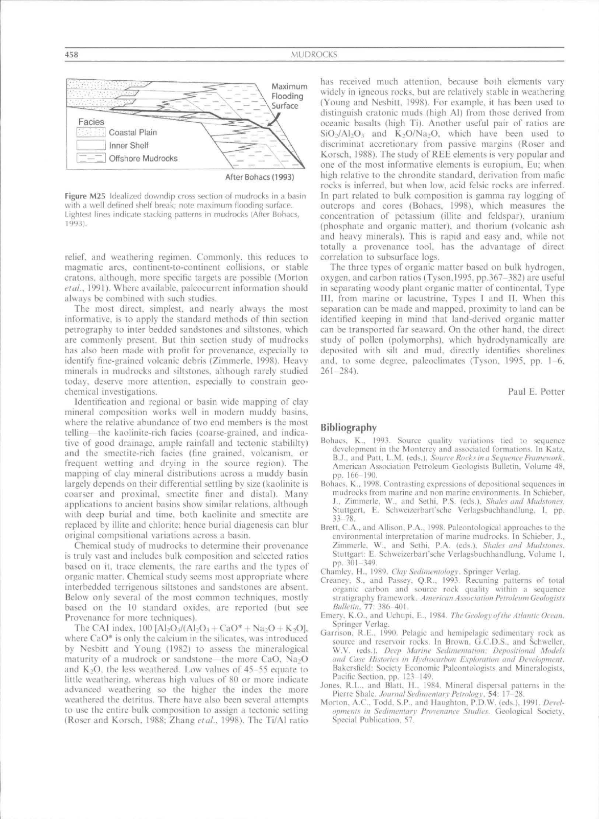
interpreted (Figure M25).
Provenance
There are live mineralogical and chemical ways to determine
the provenance of mudrocks—study their inter bedded
sandstones and siltstones with thin sections, use heavy
minerals from ihe sandstones and sillstones (and even possibly
the mudrocks), identify, and systematically map their clay
mineral composition, and .study both their inorganic and
organic chemistry. As with sandstones, the broad objective
here is insitzht to their kinds of source rocks and their location.
458
MLiDKOCKS
Maximum
_ Flooding
— -\ Surface
Facies
' Coastal Plain
Inner Shelf
Z—~ I Offshore Mudrocks
After Bohacs (1993)
Figure M25 Idealized downdip truss section of mudrocks in <i basin
with a well defined shelf break; nole maximum flooding surface.
Lighlest lines indicate stacking patterns in mudrocks (After Bohacs,
1993).
relief,
and weathering regimen. Commonly, this reduces to
magmatic arcs, continent-to-continent collisions, or stable
cratons. although, more specific targets are possible (Morton
elal.. 1991). Where available, paleocurrent information should
always be combined with such studies.
The most direct, simplest, and nearly always the most
informative, is to apply the standard methods of thin section
petrography to inter bedded sandstones and siltstones. which
are commonly present. But thin section study of mudrocks
has also been made with profit for provenance, especially to
identify fine-grained volcanic debris (Zimmerle. 1998). Heavy
minerals in mudrocks and siltstones. although rarely studied
today, deserve more attention, espeeially to constrain geo-
chemical investigations.
Identification and regional or basin wide mapping of elay
mineral composition works well in modern muddy basins,
where the relative abundance of two end members is the most
telling—the kaolinite-rich facies (coarse-grained, and indica-
tive of good drainage, ample rainfall and tectonic stabililty)
and the smectite-rich facies (fine grained, volcanism. or
frequent wetting and drying in the source region). The
mapping of clay mineral distributions across a muddy basin
largely depends on their differential settling by size (kaolinite is
coarser and proximal, smectite finer and distal). Many
applications to ancient basins show similar relations, although
with deep burial and time, both kaolinite and smectite are
replaced by illite and chlorite: hence burial diagenesis can blur
original eompsitional variations across a basin.
Chemical study of mudrocks to determine their provenance
is truly vast and includes bulk composition and selected ratios
based on it. trace elements, the rare earths and the types of
organie matter. Chemical study seems most appropriate where
interbedded terrigenous siltstones and sandstones are absent.
Below only several of the most common techniques, mostly
based on the 10 standard oxides, are reported (but see
Provenance for more techniques).
The CAI index, 100 [AI:OV(A1.O, + CaO* + Na.O + K^OJ.
where CaO* is only the calcium in the silicates, was introduced
by Nesbitt and Young (1982) to assess the mineralogical
maturity of a mudrock or sandstone the more CaO. Na2O
and K^O. the less weathered. Low values of 45 55 equate to
little weathering, whereas high values of 80 or more indicate
advanced weathering so the higher the index the more
weathered the detritus. There have also been several attempts
to use the entire bulk composition to assign a tectonic setting
(Roser and Korsch. 1988; Zhang elal.. 1998). The Ti/AI ratio
has received much attention, because both elements vary
widely in igneous rocks, but are relatively stable in weathering
(Young and Nesbitt. 1998). For example, it has been used to
distinguish eratonic muds (high Al) from those derived from
oceanic basalts (high Ti). Another useful pair of ratios are
SiO./AI.O, and K.O/Na.O. which have been used to
discriminal accretionary from passive margins (Roser and
Korsch, 1988). The study of REE elements is very popular and
one of the most informative elements is europium, Eu; when
high relative to the ehrondite standard, derivation from mafie
rocks is inferred, but when low, acid felsic rocks arc inferred.
In part related to bulk composition is gamma ray logging of
outcrops and cores (Bohacs, 1998). which measures the
concentration of potassium (illite and feldspar), uranium
(phosphate and organic matter), and thorium (volcanic ash
and heavy minerals). This is rapid and easy and, while not
totally a provenance tool, has the advantage of direet
correlation to subsurface logs.
The three types of organic matter based on bulk hydrogen,
oxygen, and carbon ratios (Tyson,1995. pp.367-382) are useful
in separafing woody plant organic matter of continental. Type
III,
from marine or lacustrine. Types I and II. When this
separation can be made and mapped, proximity to land can be
identified keeping in mind that land-derived organic matter
can be transported far seaward. On the other hand, the direct
study of pollen (polymorphs). which hydrodynamically are
deposited with silt and mud. directly identifies shorelines
and, to some degree, paleoclimates (Tyson, 1995, pp. i 6,
261 284).
Paul E. Potter
Bibliography
Boliiics. K., \9'-)y. Source qiialiiy variations lied lo suqucnue
dcvclopmunl in ihc Monieri;y and asiocialcd tormalions. In K;Uz.
B.J.. and Pat!. L.M. (eds.). Soiuri'Rmksina Sequcmf hcttnnyork.
American Association Petroleum Geoiogisis Bulleiin. Volumi: 48.
PP-
16f) 190.
Boliiics. K.. 1998. Conirasting expressions of deposilional sequenees in
mudrocks lioni marine and non marine environments. In Scliieber.
J.. Zimmerlc. W.. and Sethi. P.S. (eds.). Sluilcs and Muclsioncs.
SluUgerl. E. Scliweizerbart'sche Verlagsbuclihandlung. I. pp.
33-78.
Brett. C.A.. and Allison. P.A.. 1998. Paleontoiogieal approaches to ifie
cnvironmenlal inlerpretation of marine mudrocks. In Sehieber. J..
Zimmerle. W.. and Sethi. P.A. (eds.). Shales ami Mudsloiies.
StuUgarl: E. Schweizcrbart'scfic Verlagsbuchhandlung. Volume I.
pp.
301-349.
Chamley. H.. 1989. Clay
Sctliniciiiulcf^y.
Springer Verlag.
Creuncy. S., and Passey. Q.R,. 1993. Recuning patterns of tolal
organie earbon and source rock quality within a sequence
siraticrapliy trameuork. American Assovialion
PelroteiimGeiilo^i.'ils
Hiil/e'iin.
77: 386 401.
Emery. K.O.. and Llchupi. E., 1984. TlwGcoh^yofdiL' Ailtiiilu Ocemi.
Springer Verlag.
Garrison. R.E.. i99(). Pelagic and hemipelagie sedimentary rock as
source and reservoir rocks. In Brown. G.C.D.S.. and Sfhweller.
W.V. (eds.). Deep Marine Scdiniculaliim: Depo.siliomil Models
anil Case Hisioiies in Hydroearhon Kxphnuioij and Develapmeiil.
Bakersfield: Society Economic Paleontologists and Mineralogists,
Pacific Section, pp- l2.Vi49.
Jones.
R.L.. and Blatt. H.. 1984. Mineral dispersal patlems in the
Pierre Shale, .hnivnal Sedimeniaiv feiniim^w 54: 17-28.
Morton, A.C.. Todd, S.P-. and Haughton. P.D.W. (eds.). 1991. flcrc/-
opnietiis in Sedinienitiiy Pruvcnance Sliidiex. Geological Society.
Special Publication. 57.

MUDROCKS
459
Ncsbilt. H.W.. and Young. G.M.. 1982. tarly Proterozoie climates
ant! plale molions inferred from maior element chemistry of lulites.
Niilia-c.
299: 715-717.
O'Brien. N.R., and Slatt. Roger. M.. 1990. Arf^iliarcoiis Rack Alias.
Springer Verlag.
Polter. P.E.. Maynard. Barry.
.1..
and Pryor. W.A.. I98II. Si-Jinieii/nl-
ii^yofShale. Springer Verlag.
Roser. B.P.. and Korsch, R.J.. 1988. Provenance signatures v\'
sandstone -mudstone suiies determined using discriminant function
analysis of major elements. Clieniiinl Geohiiv. 67: 119-139.
Schieber,
.1.,
Zimmerle. W.. and Stehi. S. (eds.)'.'l998. Shales ami Mml-
slones. 1 and II: Sluggart: E. Schweizerbart'sche Veilagsbuchhan-
dlutig. 384 and 2'-Xipp.
Stow. D.A.V.. 1981. Fine-grained sediments: terminology. Qitarei-naiv
Journal En\^iiieciin^(iealo^y. 14: 243 244.
Shepiird, P.P.. 1954. Nomenelalure based on sand-silt-day ratios.
.JournalSi'diniL'nlaiy Petrology. 24: 151-158.
Tyson. R.V.. 1995. Seilimenlary Organic Matter. London: Cbapman
and
Hall.
Weaver, C.E.. 1989.
Ckiy.s.
Mmls. ami Shales. Clsevier.
Wetzel. .A., and Uchmann, A.. 1998. Biogenic structures in tniidslones.
In Sehieber. J.. Zimmerle, W.. and Sethi. P.A. (eds.). Slutlcsami
.\tiidsiiiues. I. Stuggart: Schwei/erbart'sche Verlagsbuchhandlung.
pp.
351-369.
Young. G., and Nesbitt, H.W.. 1998. Proeesses controlling the
distribution of Ti and Al in weathering profiles, siliclaslic sediments
and sedimentary rocks. Journal Sedintenlnrv Reseairh. 68: 448-
455.
Zhang, .I.L.. Sun. M.. Wang. S.. and Yu. X., 1998. The composition of
shales frotn the Ordos Basin. China: effects of source weatbering
and diagenesis. Seiliiiieniary
Genlo^^y,
116: 129 141.
Zimmerle, W.. 199S. Petrography of the Boom Clay from the Rupelian
type locality, northern Belgium. In Sehieber. J.. ZImmerie. W.. and
Sethi. P.S. (eds.). Shales and Mudsuines. I: Stuggart: Scbweizer-
bart'sche Verlagsbtichhandlung. pp.
13-3.3.
Cross-references
Blaek Shales
Clay Mineralogy
Colloidal Properties o\ Sediments
Colors of Sedirnentary Roeks
Compaction (Consolidation) of Sediments
Deposilional Fabric of Mudrocks
Flocculation
Oceanic Sediments
N
NEOMORPHISM AND RECRYSTALLIZATION
Recrystallizatioti atid neomorphism arc processes that
transfonrt tninerals in situ into diffcrctit tbrms of themselves,
or a polymorph. Cotifusion exists with the term recrystalliza-
lion becatisc it is sotiietitnes restricted to striiin induced
triitisformatioii (BLtthiirst. 1958) but at other times it is used iti
a general way for any change in form without a change o\'
mineral species. The term replacement is sometimes used for
any mineral transformation, including recrystallization and
neomorphism. Replaeement, however, is often restricted to
transformations that involve changes in bulk eomposition
(synonymous wiih metasomatism) such as dolomitization or
silicification of limestotie. Neomorphism and recrystallization
are thought to occur by simultaneous transformation across a
thin iluid film and are to be distitiguished from cementation
{mineral crystallization in fluid filled cavities). Neomorphistrt.
recrystallization and eementation all involve dissolution and
precipitation, but eement crystallizes in visible (scale of light
microscope) cavities and does not involve simultaneous
dissolution and precipitation at sites separated by a few
mierons or less.
Folk introduced the term neomorphism in 1965 to include
all transformations of older crystals that are gradually
consutncd. and their place simultaneously occupied by new
erystals of the same mineral or a polymorph. Folk pointed out
that recrystallization. used loosely, is synonymous with
neomorphism but that recrystallization sensu stricto excludes
inversion. As such, considerable overlap exists between
neomorphistn and recrystallization, and to avoid eonfusion it
must be clear whether recrystallization is being used in a strict
or loose sense. Folk added texturai riders to the term
neomorphistn to indicate an inerease (aggrading) or decrease
(degrading) in erystal size and whether an increase in size
occurred by growth frotn a few isolated crystals (porphyroid)
or every adjacent crystal (coaleseive).
The transformation of aragonite lo calcite. with or without
interstitial liquid films (Folk. 1965, p.21) has been ealled
inversion but Bathurst (1975. p.234) specifically excluded
water from the process and defined inversion as a dry, solid-
state reaetion. Folk (1965) considered dry inversion of
aragonite to calcite as a special type of neomorphism. The
dry inversion of aragonite to calcite. however, does occur
naturally in blue.schist metamorphic facies (Carlson and
Rosenfeld. 1981). The reaction path and textures produced
in this reaetion are different frotn those found in water-
saturated sediments. Consequently inversion and neomorph-
ism are both polymorphic transformation process, the former
is dry and the latter is wet and their reaction products are
readily distinguishable.
Since 1965 neomorphism has been applied most commonly
to the aragonite to calcite transformation. Investigation has
concentrated on tnollusc shells (Sandberg and Hudson, 1983:
Hendry etal., 1995; and Maliva. 1998). scleractinian corals
(Pingitore, 1976; Martin etal.. 1986). ooids (Wilkinson.
(-/(//..
1984) and botryoidal cements (Sandberg. 1985).
The overlap between recryslallization and neomorphism
and the variable number of transformation processes encom-
passed by these terms has caused confusion. This led Mache!
(1997) to reeommend the abandontnent of the term neomorph-
ism. The term can, however, be usefully applied to the wet
aragonite to calcite transformation for which it has been used
overwheltningly since 1965. Neomorphism would then become
restricted to a common and important type of polymorphic
transformation. Recrystallization, on the other hand, applies
to transformation without change in mineral speeies. Folk
(1965) used neomorphism for transformations where the
mineralogy of the precursor mineral is unknown but recrys-
tallization would be just as apt and the genera! tenn
transformation is recommended here to avoid confusion.
Calcitization is the transformation of any mineral to calcite
and as such can be a type of recrystallization (calcite to
calcite). replacement (e.g., anhydrite to calcite) or neomorph-
ism (aragonite to calcile).
Neomorphism
Neomorphic transformation of a mass of aragonite crystals
usually starts from tnany points within and at the margin of
NFOMORPHISM AND RECKYSTAt.LIZATION
461
that mass. The fluid that e.xists at each initiation point tnoves
cetitriftigally away from that point as a thin liltn until it stops
against a seam of organic matter; meets another fluid film, or
the transformation stops (Wardlaw etal... 1978; Martin elal..
1986).
The number of initiation points and the manner in
which these films move controls the resulting mosaie of
comparatively few neomorphic (sometimes a single) calcite
crystals. These are optically and texturally largely unrelated to
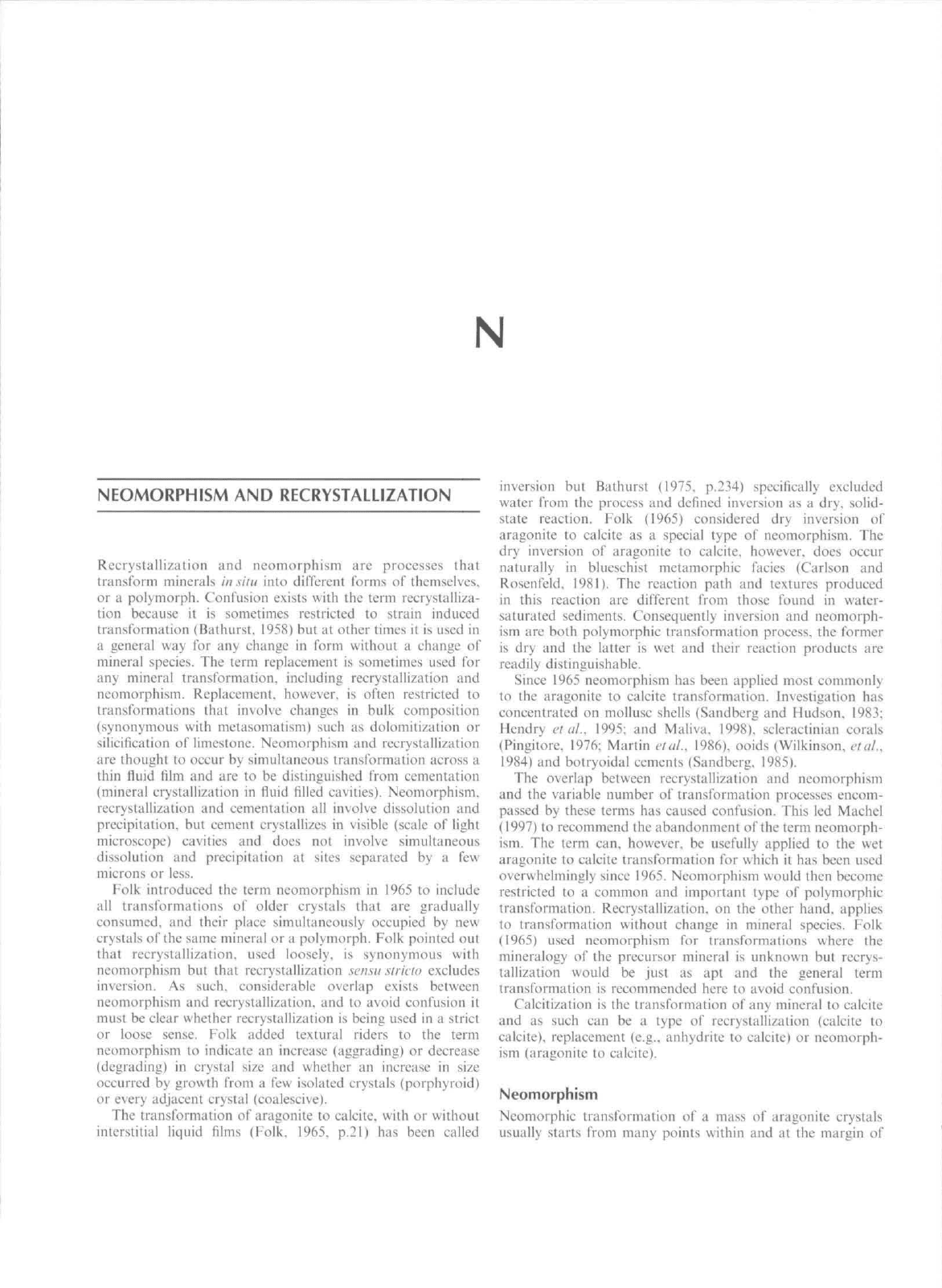
the preeursor aragonite (Figure Nl). Mineralogical transfor-
mation across such a film is often incomplete, with aragotiite
relics being found encased in the neomorphic calcite. These
relics retain their original orientation and indicate the strueture
of the transfortned grain. Palimpsest structures can also be
preserved in neomorphie calcite by trapped original organic
matter that can give rise to a pale to dark brown pseudopleo-
chroism that is distitictive of some neotnorphic calcites
(Hudson, 1962; Sandberg and Hudson, 1983). In some cases
neomorphism occurs in two stages separated by a long
(10''year) time interval (Hendry eia!.. 1995).
Transformation within the confines of a thin film (although
one has never been directly observed; Wardlaw elal.. 1978)
allows chemical information to be transferred from aragonite
to neomorphic calcite. Many neomorphic calcites contain
- i.OOOpptn Sr (tabulated in Maliva, 1998. p.l8!) a concen-
tration ahove that recorded for most calcite cements
(--300 ppm Sr) and often used to diagtiose Eransfortned
aragonite (Sandberg and Hudson. 1983). Some neomorphie
calcites. however, have Sr eoncentrations that are similar to
adjacent cements (Maliva and Dickson, 1992) and the Sr
content of neomorphic calcite is often overestimated due to
analytical problems (see discussion Pingitore. 1994 and reply
Moshierand Kirkland. 1994).
Work in the 1960s and 1970s eoneentrated on neomorphic
calcite that formed in tneteoric waters; some neomorphic
calcites described IVom vadose and phreatic environments have
different properties (Pingitore. 1976). Neotnorphic ealcite can
also form in modified marine waters (Maliva, 1995) and from
evolved isolated connate waters (Kendall, 1975; Bathursl.
1983).
In all these cases the neomorphie products are similar
and are undiagnostic of the transformation fluid.
Recrystallization
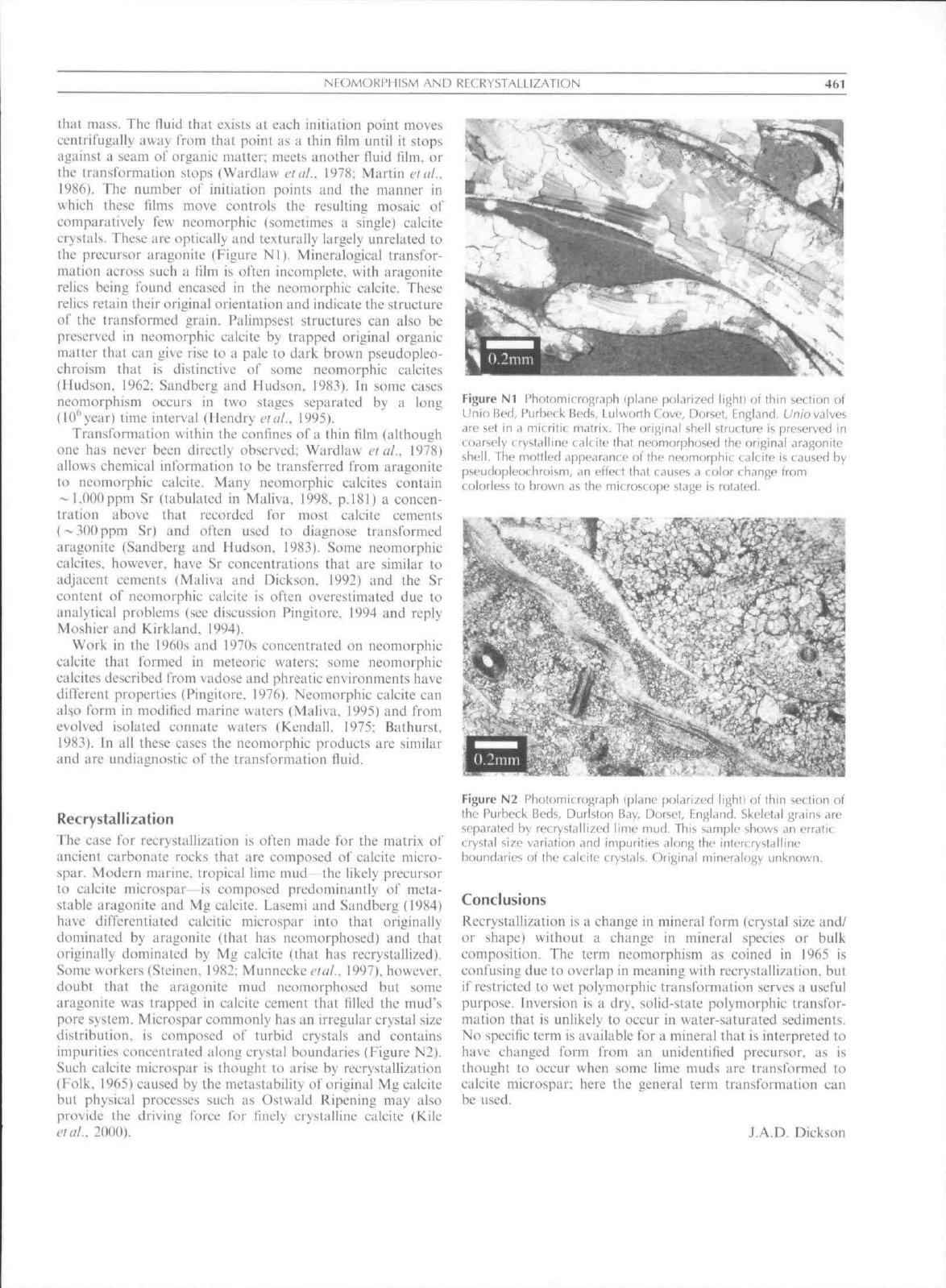
The case for recrystallization is often made for the matrix of
aneient carbonate rocks that are composed of calcite micro-
spar. Modern marine, tropical lime mud the likely precitrsor
to calcite microspar is composed predominantly of meta-
stabic aragonite and Mg ealcite. Lasemi and Sandberg (1984)
have differentiated calcitic microspar into that originally
dominated by aragonite (that has neomorphosed) and that
originally dominated by Mg calcite (that has recrystallized).
Some workers (Steinen, 1982; Munnecke elal., 1997). however.
doubt that the aragonite mud neomorphosed but some
aragonite was trapped in calcite cement that filled the mud's
pore system. Microi^par commonly has an irregular crystal size
distribution, is composed of turbid crystals and contains
impurities concentrated along crystal boundaries (Figure N2).
Such calcite tnicrospar is thought to arise by recrystallization
(Folk. 1965) caused by the metastability of original Mg calcite
but physical processes such as Ostwald Ripening may also
provide the driving force for finely crystalline calcite (Kile
etal.. 2000).
Figure Nl l-'hotomicrof!r.iph (plane polnrized light) of thin section of
Unio Red, Purheck Beds, Lulworth Cove, Dorset, England. Uniovalves
are set in a micrjtic matrix. The original shell structure is preserved in
coarsely crystalline calcite that neomorphosed the orifiinal aragonite
shell.
The mottled appearance of the neomorphic ciltite
\s
caused by
pseudopieothroism, an eflect that causes a color change from
colorless to hrown as the microscope stage is rotated.
Figure N2 Photomicrograph (plane polarized lightl of ihin section of
the Purbeck Beds, DurUton Bay, Dorset, England. Skeletal grains ate
separated by recrystallized lime mud. This sample shows an erratic
crystal size variation and impurities along the intert rystalline
boundaries of the calcite crystals. Original mineralogy unknown.
Conclusions
Recrystallization is a change in mineral fortn (crystal size and/
or shape) without a change in tnineral species or bulk
composition. The term iieomorphism as coined in 1965 is
confusing due to overlap in meaning with reerystallization. but
if restricted to wet polymorphic transformation serves a useful
purpose. Inversion is a dry, solid-state polymorphie transfor-
tnation that is unlikely to occur in water-saturated sediments.
No specific term is available for a mitieral that is interpreted to
have changed form tVom an unidentified preeursor. as is
thought to occur when sotne lime muds are tratisformed to
calcite microspar: here the general tet"m transformation can
be used.
J,A,D. Dickson
462
NEPHELOID LAYER, SEDIMENT
Bibliography
Biithuisl. R.G.C.
1958.
Diagcnctit; fabrics
in
some Britisli Diiiantian
limestones.
The
Liverpool
and
Munche.sh'r
Geoloi;ii'ijl
.lotirmtl,
2:
!1-36,
Bitthiirsl. R.G.C.
197?.
Carhomilc Sedimenis
ami
Their Diagenesis.
DcveiopmeiUs
in
Sedimenlokigy. Volume
12,
Elsevier,
Bathurst. R.G.C.
19S3.
Neomorphic spar versus cement
in
some
Jurussic ^rainstoncs: significance
tor
evaluation
of
porosity
evoiutioti atid compaction. Journal
ol the
Geological Society
of
London.
140:
229-137,
Carlson.
W.D.. and
Rosenfeld.
J.L.. 1981.
Optical detertnination
of
topotactic aragonite-calcite growth kinetics: metamorphic implica-
tions.
Journalof Geology,
89:
615-638.
Folk.
R.L.. 1965.
Sotne aspects
of
recrystallization
in
aticient
limestones.
In
Dolomitization
and
Limestone Diagenesis. SEPM
(Society
tor
SedimetUary Geology). Special Publication.
13. pp,
14-48.
Hendry.
J,P,.
Ditchfield,
P,W,, and
Marshall.
J.D.. 1995.
Two-stage
neomorphism
of
Jurassic aragonitic bivalves: implications
tor
early
diajicncsis. .lourmdofSedimemary Research,
A65:
214-224.
Hudson.
J,D,. 1962.
Pseudo-pleocliroic calcite
in
recrystallized shell
limestones.
Geological
Afat^aiine.
99: 492 500.
Kendall.
A.C.. 1975.
Post-compaclional calciti,^ation
of
molluscan
aragonite
in a
Jurassic litnestonc Irom Saskatchewan. Canada.
Journal of Si'dimenUnv
Pelrolof^v.
45: 399 404,
Kile.
D.F,,. Fbcrl.
DD.^
Hoch.
A,R,. and
Reddy.
M,M..
2000.
An
assessment
of
calcite crystal growth mechanisms based
on
crystal
size distributions. Geochimica
et
Cosmochimica Acta.
64:
2937
2950,
Lasemi.
Z,. and
Sandberg.
P.A.. 1984.
Transformation
of
aragonite-
dominaled lime mtids
to
mierocrystalline limestones. Geology.
12:
420-423.
Machel.
H.G.. 1997.
Recrystallization versus neomorphism.
and the
concept
of
"significant recrystallization"'
in
dolomite research.
Sedimentary Geology.
113: 161- I6K.
Maliva.
R.G.. 1995.
Recurrent neotnorphic
and
cement microtextures
from different diagenetic environments. Quaternary
to
Late
Neogene carbonates. Great Bahatna Bank. Sedimentary Geologv.
97:
17.
Maliva.
R.G.. 1998,
Skeletal aragonite neomorphistn quantitative
modelling
of a
two-water diagenetic system. Sedimentary Geologv.
121:
179-190,
Maliva,
R.G,. and
Dickson. J,A,D,. 1992.
The
mechanism
of
skeletal
aragonite neomorphism: evidence from neomorphosed molluscs
from
the
upper Purbeek P'ormation (Late Jurassic Early Cretac-
eous),
southern Enijland, Sedimentary
Geologv.
76: 221 232,
Martin.
G,D,.
Wilkinson. B,H,,
and
Lohiiiann. k',C,. 1986,
The
role
of
skeletal porosity
in
aragonite neomorphism Slroiiibus
and Mon-
uistrea from
the
Pleistocene
key
Largo Limestone. Florida.
Journal
1)/
Sedimentary Petrology.
56:
194-203.
Moshier.
S,0,. and
Kirkland.
B,L,, 1994,
Ideiilitication
and
diagenesis
of
a
phylloid alga: .Archaeoliihophyllum trom
ihe
Pennsylvimian
Providenee Limestone. Western Kentucky reply. Journal
id
Sedimentary Petrology.
64:
925-928.
Munnecke.
A,.
Weslphal,
H,.
Reijmer. J.J,G,.
and
Samtleben.
C.
1997,
Microspar development during early marine burial diagen-
esis:
a
comparison
of
Pliocene carbonates from
the
Bahamas with
Silurian limestones frotn Gotland (Sweden), Sedimcntologv.
44:
977
990,
Pingilore.
N.F.. 1976.
Vadose
and
phrealie diagenesis: processes,
products
and
their recognition
in
corals, Jimrnal
of
Seetimemary
Pelroiogy.
46\
985-1006,
Pingitore.
N,E.. 1994,
Identification
and
diagenesis
of a
pliylloid alga:
Archaeolitliophyllum from
the
Pennsylvanian Providence Litne-
stone. Western Kentucky—ciiscussion. Journal
of
.Sedimentary
Rf.'fearch.
64:
923-924,
Sandberg.
P,A,. 1985,
Aragonite cements
and
their occurrence
in
ancient limestones.
In
Carbonate Cements. SFPM (Society
for
Seditnentary Geology). Special Publication.
36. pp,
33-57.
Sandberg.
P,A,. and
Hudson.
J,D,, 1983,
Aragonite relic preservation
in Jurassic calcite-rcplaced bivalves, Sedimentology.
30: 879 K92,
Sicinen.
R,P,. 1982, SEM
observations
on the
replacement
of
Bahanian aragonitic
mud by
calcite. Geology.
10: 471 475,
Wardlaw.
N..
Oldershaw.
A., and
Stout.
M,.
I97S. Transformation
of
arai>onite
to
ealcite
in a
marine gastropod, Canadian Journal
of
Earih Sciences.
15:
1861 -1866,
Wilkinson.
B.H..
Btiezynski.
C. and
Owen.
R.M.. 1984,
Chemieal
control
of
carbonate phases: implications from tapper Pennsylva-
nian calcite-aragonite ooids
of
southeastern Kansas, Journalof
Sectimemary Petrology.
54: 932 947,
Cross-references
Cements
and
Cementation
Di agenesis
Micritization
Sedimentologists
NEPHELOID LAYER, SEDIMENT
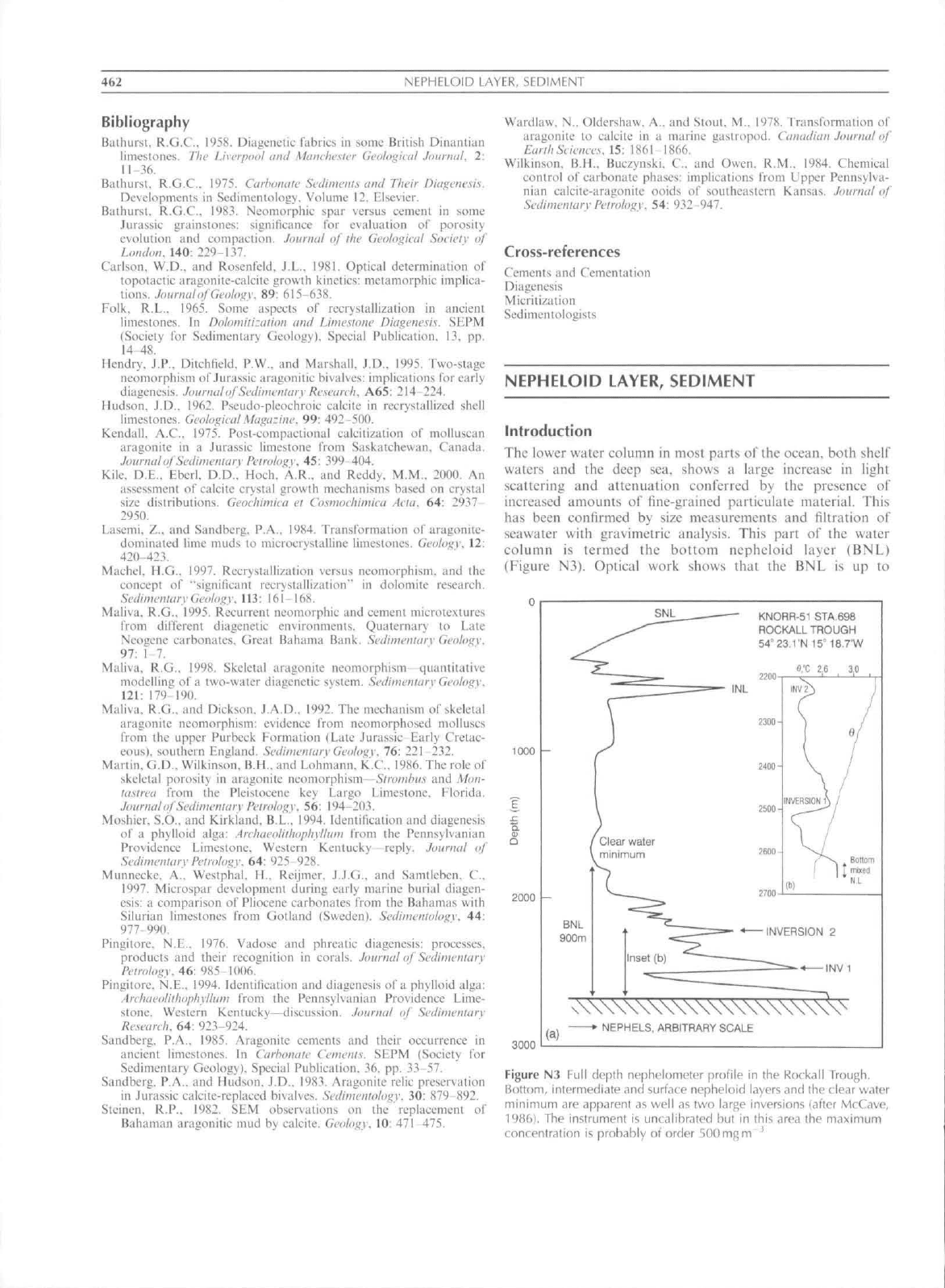
Introduction
The lower water colutnii
in
most parts
of the
ocean, both shelf
waters
and the
deep
sea.
shows
a
large inerease
in
light
scattering
and
attenuation eonlerred
by the
presence
of
increased amotints
ol"
fine-grained parlicitlate material. This
has been eonfirmed
by
size nieasuretnents
and
filtration
of
seawater with gravimetric analysis. This part
of the
water
column
is
termed
the
bottom nepheloid layer
(BNL)
(Figure
N3),
Optical work shows that
the BNL is up to
1000
2000
3000
SNL
KNORR-51 STA.698
ROCKALL TROUGH
54°
23,1
N 15-
18.7'W
(a)
v\\\\\\\\\\\\\\\\\\\\\V
•
NEPHELS, ARBITRARY SCALE
Figure N3 Full depth nephulomuter [jrolile in thf RockdII Trough,
Bottom,
intermediate and surface nepheloid layers and the clear waier
minimum are apparent as well as two large inversions (after McCavo,
19861.
The instrument is uncalibratcd bul in this area the maximum
concentration is probably of order 500 mgm
'
NFPHFI.OID lAYER, SEDIMENT
463
2000 m thick and gener:illy has a basal uniform region, the
bolloni mixed nepheloid layer, corresponding quite closely to
the bottom mixed layer defined by constant potential
temperature. Above this light scattering falls olT more or less
exponentially to the clear-water minimum marking the top of
the BNL,
Another class of nepheloid layer found especially at
continental margins is the intermediate nepheloid layer (INL)
occurring frequently at high levels off the upper continental
slope and al the depth of the shelt^-edge (Figure N3). These
INLs are similar to the inversions observed in the BNL on
some profiles (Figure N3).
Nepheloid layers of both types arc principally produced by
resuspeiision of the bottom sediments. Their distribution thus
indicates the dispersal of resuspended sediment in the oceans
and coastal seas. Most concentrated nepheloid layers occur on
the continental
shelf,
upper slope or deep continental margin.
They indicate the locus of active suspension and deposition by
strong bottom currents. Nepheloid layers off the shelf almost
always have concentrations <1 gm ".
A surface nepheloid layer (SNL) occurs almost everywhere
but varies in strength seasonally. In the open ocean il is mainly
due to phytoplankton. whereas in shelf seas it is often the
seaward extension of river oulllow plumes.
Optics: what instruments "see"
Mosl deteclion of deep ocean nephetoid layers has been
through measurement of light scattering or nephelomelry.
Because most nephelometers do not measure a defined optical
parameter iheir outputs cannot be quantitatively compared,
save via calibration with some standard such as Formazin,
Nowadays transmissometry is more commonly used for
precise work. Most of the light scattering recorded b>
nephelometers is caused by fine particles. Although larger
particles are present, they are rare and are not important
contributors to the signal. For a transmissometer. the
transmission T is related to beam attenuation coefficient c
o\cr pathlength /as T=Q ' . Attenuation is due to absorption
a and scattering h. thus c=^a + b. The value of c for pure
seawater is 0,36()±0.0()5m ' for an instrument operating at
/.-660nm, and any excess is due to particulate effects.
Because large particles scatter more at angles very close to
the beam axis, the transmissometer is more sensitive to larger
particles.
Bottom nepheloid layer features and origin
The principal features of BNLs are that the concentration is
generally highest close to the bed and decreases upward, but
with important increases or inversions. The thickness of the
BNL is generally in the region of 500m to 1500m, and
exceptionally up to 2000 m, This is clearly greater than the
thickness of the bottom mi,\ed layer, a fact which precludes the
possibility of simple mixing by boundary turbulence being a
sufficient mechanism for BNL generation. Inversions, upward
increases of concentration, become less common in the upper
part of the bottom nepheloid layer. Pronounced inversions
(INLs) are seen over slopes and on margins wiih canyons.
These are produced by internal wave and tide resuspension
(Dickson and McCave. 1986). Thus some canyons act as point
sources for supply of turbid layers which mix out into the
ocean interior (Gardner. 198'J). These features are accounted
for in the "separated mixed-layer model" in which vertical
transport by turbulent mixing in bottom boundary layers of
lOm to 100m thickness, is followed by their detachment and
lateral advection along density (isopycnal) surfaces. The
detachment occurs where isopycnals intersect ihe bottom and
this is likely to occur both in areas of steep topography with
reliel'of hundreds of meters, and also in areasof lower gradient
at benthic fronts where sloping isopycnals intersect the bottom
(Armi and D'Asaro. 1980: McCave. 1983), With time these
layers thin by mixing at their boundaries and lateral spreading
to yield, eventually, a uniform stratification.
Particles comprising the nepheloid layer arc modified by
aggregation with similar sized particles, scavenging by larger
rapidly settling ones, and by biologieal activity. Particles tend
to settle and be deposited from the bottom mixed layer. The
larger particles should be deposited in a few weeks to months.
iOnm to 20nm particles taking 50 days to 20 days to settle
from a 60 m thick layer. This affects the iransmissometer signal
but has little effect on the nephelometer record because the
timescale of fine particle removal involves Brownian aggrega-
tion with a "half-life" of several months to years giving fine
material in dilute nepheloid layers a residence time of years
{McCave. 1984). The dilute nepheloid layers in tranquil parts
of the oceans could thus contain material originally resus-
pended very far away. The contribution of ihis material to the
net sedimentation rate of these tranquil regions may not be
negligible. The rate of deposition in the Pacific of only
0.5nimka ' to 2mmka ' could include up to
1
mm ka~' of
fine material from the nepheloid layer.
The turbidity minimum
Over ihe depths separating the BNL from the SNL (and from
shelf edge and upper slope INLs) stratification is weak,
primary production of organic matter is absent and ihe ocean
is often under-saturated with respect to calcite. aragonite
and opal. Supply of particles from the side is thus scarce
and decreasing downward transport due to dissolution and
bacterial consumption of particles leads to a nepheloid
minimum where (in the Atlantic) eoncentrations are
5
mg to
20mgm , Concentrations given by nephelometers at the
minimum differ by a factor of about three between areas under
high surface productivity (high) and mid gyre regions (low).
Thus,
the flux of large particles f>om the surface in these areas
appears to provide a seasonal supply of smaller particles to
mid-depth rather than their removal by scavenging. Temporal
variability also occurs seasonally with higher mid-water
turbidity under higher summer productivity.
Regional distribution
In general, deep western boundary currents and regions of
recirculation carry high particulate loads. However, the
highest turbidity is also found beneath regions of high surface
eddy kinetic energy (variance of current speed)- The broad
picture of high speed inflows on the western sides of ocean
basins with a distributed return tlow. demonslrated by
hydrographic and current measurements, is reflected in the
distribution of BNL concentration for the Atlantic and Indian
Oceans. Nevertheless several areas of very high concentration
or load are not obviously related to likely increases in mean
bottom fiow velocity, for example the center of the Argentine
4 (.4
NERITIC CARBONATE DEPOSITIONAL ENVIRONMENTS
Basin (Biscaye
and
Eiltreim. 1977). These turbidity highs
may
be caused
by
intermittently high velocities.
The fact that there
is
more suspended materiai
at
ocean
depths greater than about 4000
m
partly refiects
the
fact that
waters
at
those depths
are in
contact with
a
much greater
potential source area
of
seabed
in
proportion
to
their volume
than
the
shallower parts
of
the oceans.
For
4 km
lo ? km
depth
the value
is
0.83 km"/km
.
whereas
for
2 km
to
3
km it is
0.11 km"/km"\ Deeper waters feel more
bed.
L Nicholas McCave
Bibliography
Armi.
L,.
iind D"Asaro,
E,.
1980, Flow structures
of
the benthic oceiin.
Journal of Geophysical Research.
85: 469 4S4.
Biscaye.
P.F,. and
EiUreim.
S,L,.
1*^77,
Stispendcd partiLiilalc loads
and Iransporls
in
liie nephcloid layer
of
the abyssal Atlantic Oceiui.
Marine
Geology.
23: 155 172.
Dickson.
R.R,. and
McCave,
LN,. 1986,
Nepheloid layers
on the
continental slope west
of
Poreupine Bank, Dvep Sea Research.
33:
791
818,
Gardner.
W,D,. 1989,
Periodic resiispcnsion
in
Baltimore Canyon
by
Ibcusinu
of
intcrna! waves. Journal
af
Geophysical Research.
94:
I8I85-I8I94,
McCave.
LN,.
1983. Particulate size spectra. heliii\iour arui origin
of
nepheloid layers over
the
Nova Scotian Continental Rise, Journal
of
Geophysical
Research.
88:
7647-7666.
MeCave.
I,N,. 1984,
Size-spectra
and
aggregation
of
suspended
particles
in the
deep oceiin, Deep-Sca Research. 31: 329-352,
McC;ive.
LN,.
1986. Local
und
global aspects
of
the boltom nepheloid
layers
in ihe
world ocean, Netherlands Joiaiialot Sea Research.
20:
167-181.
Cross-references
Continenlal Rise
and
Slope
FloccLilation
NERITIC CARBONATE DEPOSITIONAL
ENVIRONMENTS
Introduction
Marine carbonate sedimentation (Bathurst.
1975;
Scholle
etal.,
1983:
Tucker
and
Wright.
1990;
James
and
Kendall.
1992;
Wright
and
Burchette.
1996)
takes plaee
in two
environments,
the
benlhic, neritic realm
and the
pelagic
deep-sea realm
(see
Oceanic Sediments). Neritic carbonate
sediments
are
"born"
as
precipitates
or
skeletons within
the
depositional environment. This attribute
has
profound
con-
sequences:
(I)
large structures such
as
platforms
are
produced
entirely
by
sediments formed
in
place, they
are
self-generating
and self-sustaining;
(2) the
temporal
and
spatial style
of
accumulation depends upon
the
nature
of the
sediments
themselves;
(3)
sediment production
can
fill accommodation
space
and
thus create shallowing-upward. autoslraligraphic
patterns;
(4)
grain size variations need
not
signal changes
in
hydraulic regime;
and (5)
sediment composition
is
fundamen-
tal
in
characterizing
the
depositional environment.
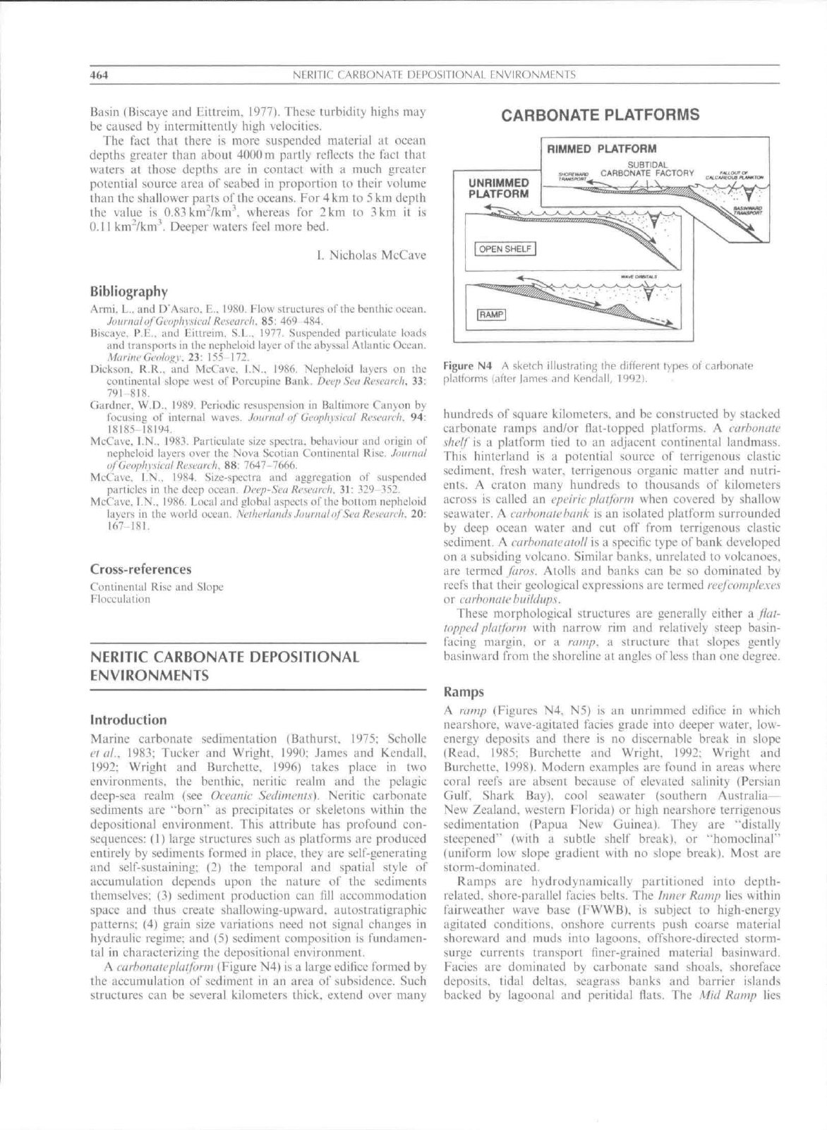
A carhotuiteplatfortn {Figure
N4) is a
large edifice formed
by
the accumulation
of
sediment
in an
area
of
subsidence. Such
structures
can be
several kilometers thick, extend over many
CARBONATE PLATFORMS
Figure
N4 A
sketch illustrafing
Ihe
different types
of
carbon^ate
platforms (after lames and Kendall, 1992).
hundreds
of
square kilometers,
and be
constructed
by
stacked
carbonate ramps and/or flat-topped platforms.
A
cat-hoiiatc
\/?('//
is a
platform tied
to an
adjacent continental landmass.
This hinterland
is a
potential source
of
terrigenous clastic
sediment, fresh vi'ater. terrigenous organic matter
and
nutri-
ents,
A
craton many hundreds
to
thousands
of
kilometers
across
is
called
an
epeiric plaiforni when covered
by
shallow
seawater.
A
carhotuitehattk
is an
isolated plattbrm surrounded
by deep ocean water
and cut off
from terrigenous clastic
sediment,
A
cufhonateatol!
is a
specific lype
of
bank developed
on
a
subsiding volcano. Similar banks, unrelated
to
volcanoes,
are termed faros. Atolls
and
banks
can be so
dominated
by
reefs that their geological expressions
are
termed fcefcomple.xes
or cufbonali'buildups.
These morphological structures
are
generally either
-d
fiat-
lopped platform with narrow
rim and
relatively steep basin-
tacing margin,
or a
ramp,
a
structure that slopes gently
basinward from
the
shoreline
at
angles
of
less than
one
degree.
Ramps
A ratnp (Figures
N4. N5) is an
unrimmed edifice
in
which
nearshore, wave-agitated facies grade into deeper water,
low-
energy deposits
and
there
is no
discernable break
in
slope
(Read.
1985;
Burchette
and
Wright.
1992:
Wright
and
Burchette, 1998), Modern examples
are
found
in
areas where
coral reefs
are
absent because
of
elevated salinity (Persian
Gulf.
Shark
Bay),
cool seawater (southern Australia—
New Zealand, western Florida)
or
high nearshore terrigenous
sedimentation (Papua
New
Guinea), They
are
"distally
steepened" (with
a
subtle shelf break),
or
"homociinal"
(uniform
low
slope gradient with
no
slope break). Most
are
storm-dominated-
Ramps
are
hydrodynamically partitioned into depth-
related, shore-parallel facies belts.
The
Ititier Ramp lies within
fairwcathcr wave base (FWWB),
is
subject
to
high-energy
agitated conditions, onshore currents push coarse material
shoreward
and
muds into lagoons, offshore-directed storm-
surge currents transport finer-grained material basinward.
Facies
are
dominated
by
carbonate sand shoals, shoreface
deposits, tidal deltas, seagrass banks
and
barrier islands
backed
by
lagoonal
and
peritidal flats.
The Mid
Ramp lies