Gardiner V., Matthews H. The changing geography of the United Kingdom
Подождите немного. Документ загружается.


DAVID JONES
356
anywhere. Thus, the only feasible loss-reduction solution is to concentrate on saving lives
and minimising damage to property by the employment of sophisticated monitoring
techniques (e.g. radar, and interrogable rain-gauge and river-level systems) and the
development of efficient warning and evacuation procedures.
While the majority of floods are generated by ‘natural’ mechanisms, human activity
has been of considerable significance in changing the discharge characteristics of rivers
and, under certain circumstances, has contributed to flood generation. Urbanisation
has had a particularly great impact, for the sustained rapid rate of land conversion,
which reached 26,000 ha per year in the early 1970s, results in a wide variety of
hydrological consequences (Figure 17.9). Erosion during construction can cause
suspended sediment concentrations to rise by factors of two to ten, and sometimes up
to one hundred, the resultant sedimentation downstream increasing flood risk and raising
channel maintenance costs. Once completed, the urban areas provide radically different
surface conditions, for the buildings, roads and integrated stormwater and sewer systems
cause reductions in interception and infiltration to soil and groundwaters, and result
instead in the rapid run-off of an increased proportion of precipitation. As a consequence,
even partially urbanised catchments show increased annual water yields, higher peak
FIGURE 17.9 The potential range of changes to hydrological parameters produced by
urbanisation Source: After Douglas (1976).
HUMAN OCCUPANCE AND THE PHYSICAL ENVIRONMENT
357
flows and more rapid responses to precipitation events (reduction in basin lag-times).
This increase in flashiness is particularly apparent for summer floods on small
catchments, which may experience up to an elevenfold increase in peak discharge,
thereby contributing to the widely reported enlargement of channels downstream of
urban areas. However, the urban influence is only apparent on small and medium-sized
floods, for there are few indications that discharges with recurrence intervals in excess
of twenty years are affected, possibly because high flows result in a ‘throttling’ (holding
back) of water in urban stormwater sewers.
Urbanisation is not merely associated with locally increased flooding, for water
supply and effluent disposal can produce significant changes in river regime. Reductions
in discharge result from reservoir construction, direct abstraction and the drying-up of
springs due to the over-exploitation of underground aquifers, with the result that many
chalkland streams have shrunk, dried-up or become only periodically active. In the
case of the Chalk beneath London, aquifer water-table lowering amounted to up to 60
metres in the period 1875–1965. However, growing concern about undergroundwater
resources has resulted in recent careful regulation of extraction. This, together with the
employment of artificial recharge schemes (e.g. near Newbury) has halted the trend in
many cases and is actually causing some water tables to rise again, most significantly
beneath London where the rise has been so dramatic as to pose a real threat to basements
and buried infrastructure, including the underground railways. Conversely, increased
base-flow can result from the release of large volumes of water redistributed by piped
water supply systems as inter-basin transfers (see Chapter 2). The scale of such allogenic
water supplies is most apparent in the case of Birmingham where used-water, originally
derived from the upper Wye in Wales and piped to the Midlands, is discharged into the
Trent catchment. Many of the larger rivers appear to have a base-flow that is
predominantly effluent, the River Tame being 90 per cent effluent in its 95 per cent
duration flow.
Anthropogenic influences on flooding are not restricted to urbanisation, for recent
agricultural developments have also had important hydrological consequences. The expansion
of arable cultivation, the enlargement of fields by the removal of hedges and copses, the use
of machinery which compacts soil thereby reducing infiltration, and the massive post-war
growth in the use of tile-drains, have all contributed to the increasingly rapid transport of
larger and larger proportions of precipitation from slopes into channel systems. Thus, the
flashiness of most streams and small rivers in lowland Britain has been increased during the
last half century.
Coastal flooding
A very different flood-hazard threat exists around the coastline of Britain, where adverse
weather conditions combined with slowly changing land-sea relationships result in occasional
breaches of defensive structures and the inundation of adjacent lowlands by saline water.
The most important recent examples of such events are the Uphill (Somerset) floods of 13
December 1981, the Selsey (Sussex) floods of 4–5 January 1998 and the Towyn (Clwyd)
inundation of 26 February 1990. The Towyn flood was the most significant of these events,
inundating 2,800 homes and resulting in the evacuation of 5,000 people from the town
itself. It also highlighted many of the features of coastal flooding: the high proportion of old
DAVID JONES
358
FIGURE 17.10 Generalised pattern of predicted sea-level change
Sources: Modified from Jones et al. (1993b) and Wigley and Raper (1992).
HUMAN OCCUPANCE AND THE PHYSICAL ENVIRONMENT
359
people affected because of the tendency to ‘retire to the coast’, the low proportion of
inhabitants with contents insurance, and the high levels of trauma which result in significant
numbers of post-event deaths (fifty-four in the Towyn case).
It is along the coastline of eastern and southern England that the threat is greatest
with documented records of local coastal flooding along the east coast dating back to
1236, including at least seven inundations that were of disastrous proportions. Here,
local tectonic movements, including the progressive downwarping of the North Sea
basin, together with the global (eustatic) rise in sea-level (currently c. 1.2 mm per annum)
and changes in tidal configuration due to dredging, dumping, reclamation and coastal
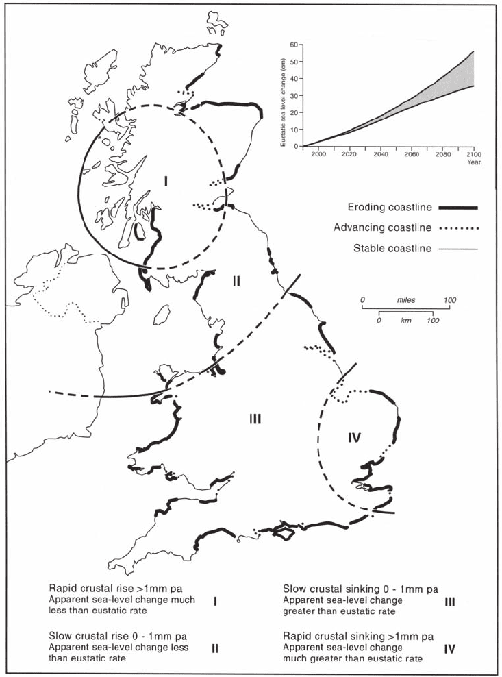
defences, have combined to produce significant rates of local sea-level rise. Analysis of
tide-gauge records in the South East indicate that sea-level is currently rising at varying
rates of 140–540 mm/100 years (Figure 17.10). The higher figures are from the Solent,
Dover Straits and Lower Thames because of changing tidal characteristics. This situation
of gradually rising high-water levels is exacerbated by the occurrence of storm surges
generated by deep depressions tracking over the North Sea or along the Channel. Sea-
surface levels can be raised over 2m through the combined effects of pressure reduction
(305 mm rise for each 30 mbs reduction in atmospheric pressure) and the piling of
water against the coast by strong on-shore winds. Coastal defences become severely
stressed when these surges coincide with particularly high (Spring) tides, and can be
over-topped and breached by high waves generated by the strong winds (e.g. Selsey,
Sussex, January 1998). The risks are even greater in estuaries, for any reduction in
wave-heights resulting from sheltering is more than compensated for by the raising of
surge level due to funnelling, and the water surface may be dramatically raised still
further if a surge coincides with a period of high river flow into the estuary. As extensive
coastal tracts bordering the North Sea and the Channel stand at elevations little above
mean sea-level, the potential for disastrous inundations is great. The economic
consequences of such an event could be enormous and include the saline contamination
of agricultural land and groundwaters, the swamping of residential areas, the paralysis
of waterside industries, the dislocation of communications, and the severe disruption
of activity in London.
The dramatic events of the night of 31 January/1 February 1953 graphically illustrated
the problem and were to have particularly great repercussions in terms of risk perception
and the implementation of remedial measures. Stormforce winds generated by a deep
depression (minimum 968 mbs) drifting south-eastwards across the North Sea caused a
surge up to 2.5 metres high to pass southwards down the east coast. Fortunately, the passage
of the surge did not quite coincide with the progression of only a moderately high tide and
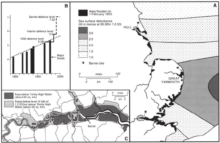
the rivers were not in spate. Nevertheless, 850 square kilometres were inundated (Figure
17.11) along nearly 500 kilometres of coastline (the so-called Isle of Thanet reverted to a
true island for a short time), 24,000 houses were swamped, cement works, factories and
power stations on Lower Thameside were inundated and brought to a standstill, and 307
people were drowned. The subsequent committee of enquiry focused attention on the factors
causing flooding and stressed that the situation would get progressively more serious due to
regional subsidence. The initial reaction was to strengthen and raise the level of sea defence
(levees, walls, etc.) from Yorkshire to Kent so as to allow them to withstand 1953 surge
levels, a task that took fourteen years (1954–68) and cost £55 million. The new defences
were completed none too soon, for although the initial recurrence interval calculated for the
DAVID JONES
360
1953 surge level was 200 years, the 1953 heights have subsequently been locally equalled
or exceeded on three occasions: 29 September 1969, 3 January 1976 and 11/12 January
1978. The 1978 event involved a surge of up to 1.73 metres coinciding with the highest
tide of the fortnightly cycle and produced levels which were locally well in excess of
those recorded in 1953. In this instance, flooding was most severe around the Wash and in
Lincolnshire (King’s Lynn, Wisbech and Cleethorpes), with damage estimated at £200
million (but only one death). The relatively high damage costs indicate that although the
defences were much stronger and restricted flooding, there had been only limited
implementation of land-use zonation in association with the engineering works. Thus,
residential, commercial and industrial activity continued to be located on the high-risk,
low ground behind the defence, in the belief that such areas are safe because they are
protected (the so-called ‘levee syndrome’). On the other hand, the low death toll reflected
the improved forecasting and warning systems that now operate and the better-disciplined
evacuation procedures that stem from greater hazard awareness. Particularly significant
in this context is the Storm Tide Warning Service established in 1954 by the Meteorological
Office at Bracknell, which delivers phased warnings to relevant organisations; an ‘alert’
twelve hours before expected high-tide followed by ‘confirmations’ (or cancellation) at
four hours and ‘danger warnings’ at 1–2 hours. As from September 1998 this operation
will be known as the Storm Tide Forecasting Service to reflect the fact that it does not
issue general warnings and to distinguish it from the Environment Agency which does
issue warnings.
The protection of the coast represents a costly but technically less difficult problem
than that of defending the land flanking the Lower Thames (Figure 17.11). No less than
FIGURE 17.11 East coast flood hazards: (A) the 1953 flood; (B) rising surge levels and defences
along the lower Thames; (C) the hazard zones in London
HUMAN OCCUPANCE AND THE PHYSICAL ENVIRONMENT
361
61.4 square kilometres of London lies below Trinity High Water Mark (+3.48 metres OD)
and 116 square kilometres below the 1953 flood level (+5.48 metres OD). Fortunately, the
1953 surge only affected 1,100 houses in east London because vast volumes of water had
escaped from the confines of the Thames estuary through the numerous breaches along the
Essex shore. A repeat of the 1953 surge, but with no such water escape, would be catastrophic
for the capital city, with a currently estimated damage potential well in excess of £5,000
million. Unfortunately, the area at risk is growing steadily due to the combination of local
and regional subsidence, progressively accelerating eustatic rise due to global warming
(Figure 17.10) and changing tidal configuration. Thus, although the medium tide level at
Tower Pier is rising at 433±82 mm/100 years, only slightly more than the outer estuary
figure of 344±70 mm/100 years recorded at Southend, the high-tide level at Tower Pier is
rising more rapidly (744±116 mm/100 years) due to the mean tidal amplitude growing at
344±70 mm/100 years.
The management response has been to construct a flood barrier in the Long Reach at
Silvertown, near Woolwich, and to raise flood defences downstream of this structure.
Defences upstream through Central London to Teddington Weir had already been raised to
+5.28 metres in 1930–5, following the disastrous Thames flood of 1928 (+5.15 metres at
London Bridge, fourteen drowned). These were further raised to +5.80 metres between
April 1971 and December 1972 as an interim protection measure (removed in 1986) and a
movable barrier constructed at Bow Creek to avoid raising banks along the highly
industrialised Lee Valley. However, the main protection is derived from the movable drum
barrier across the Thames designed to give protection against the 1,000-year flood (+7.2
metres OD). The choice of the Long Reach site was governed by the need for firm foundations
(Chalk) and a straight section of river to ease navigation problems—a need that has
subsequently declined with the closure of the Port of London. Work was begun in 1974 and
completed in November 1983, over two years late because of technical problems and labour
disputes. The cost had similarly escalated dramatically due to inflation and spiralling labour
costs, the 1960 estimate of £10 million rising to £242 million in 1978 and £500 million in
1983. The total cost of works, including the raising of downstream defences to Southend
and the construction of a barrier across Dartford Creek, came to about £700 million at 1983
prices.
Continuation of present physical trends, plus the accelerating rise in eustatic sea-level
anticipated through CO
2
induced climatic warming (Figure 17.10), makes it inevitable that
even higher defences and more ambitious schemes will be required in the near future. The
Thames Barrier is currently raised about twice a year for defence purposes, but by 2030 the
figure will have risen to about ten times per year and consideration is being given to
establishing a new, higher line of defence to cope with a rise in mean sea-level of at least 0.5
metres by 2100 (‘Project 2100’). Elsewhere, sea-defences and river levees will have to be
raised and more movable barriers constructed across inlets, similar to that completed across
the River Hull at Hull. The number of people threatened by sea-flooding, currently estimated
at over 200,000, will have undoubtedly increased greatly thereby raising alarm in the
insurance industry and highlighting the perceived need for additional defence measures.
The key question is whether engineered measures designed to defend every metre of
vulnerable coast will be cost-effective or desirable in the long term, thereby raising the
possibility of an alternative strategy involving a phased retreat from the most threatened
sections of coastline.
DAVID JONES
362
Human occupance and climate
The interactions between human society and climate are complex and continuously evolving.
As already mentioned, despite technological development, weather phenomena remain a
major source of cost to the UK economy. Heavy precipitation, atypical prolonged snowfall
(south-east England in 1985/6 and 1986/7), unusually intense cold (-28°C, Kent, February
1985) and drought (1976) have all extracted significant levels of ‘natural tax’ in recent
years. Rainfall and freezing conditions are probably the most widespread and pervasive
problems, causing repeated heavy costs to the agricultural, transportation and construction
sectors. Locally intense weather features also remain problematic, with thunderstorms causing
scattered problems due to lightning strikes, hailstone damage, violent downbursts of wind
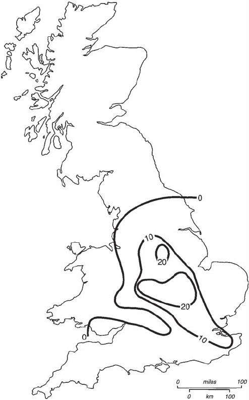
and heavy rain (Figure 17.8). Even tornadoes occur, with an average of thirty-two reports a
year, mainly in southern and central England (Figure 17.12), with the highest frequency
and severest examples (e.g. the Selsey Tornado of 7 January 1998) occurring during the
period September-January when the temperature contrasts between polar and tropical air-
masses along frontal zones are at their greatest. But the most problematic hazard remains
the wind.
The British Isles are amongst the windiest areas on the globe and gale damage is
estimated to affect an average of 230,000 buildings a year, resulting in costs of £15–20
million (at 1987 prices). High-magnitude/low-frequency windstorms (tempests) achieve
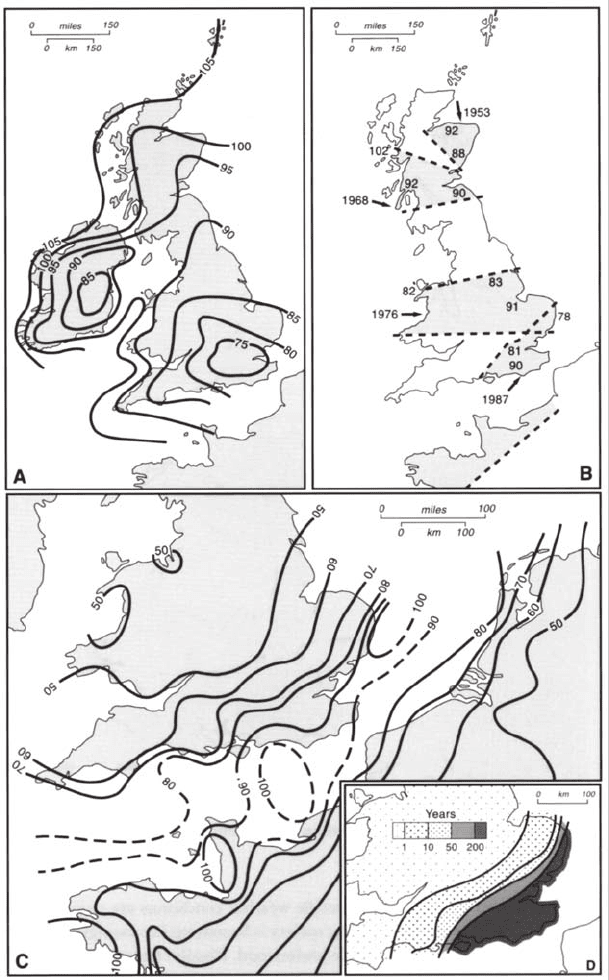
much greater impacts. The January 1953 gale blew down 5 per cent of the total standing
value of coniferous timber in the UK (Figure 17.13); the January 1968 gale damaged
340,000 houses in the Glasgow area, and the gale of 2 January 1976 caused widespread
damage throughout England, Wales and Ireland. More recently, the storm of 16 October
1987 had winds gusting up to 166 kph which devastated much of south-east England and
represented the most severe event to affect that area since the ‘greatest storm on record’
(26 November 1703) which killed about 8,000 people. This time there were a mere nineteen
deaths, although the destruction, damage and disruption was enormous as 15 million
trees in full leaf, with root holds weakened by the saturated soil, were either broken or
blown down wholesale by the violent gusts (Figure 17.13). It is fortunate that the most
violent winds passed over the land during the night (2–4 a.m.) when most people were
safely in their homes.
Since then there have been a number of powerful storms produced by deep
depressions rushing eastwards over the British Isles, each of which has resulted in
significant adverse impacts at regional levels because heavy snowfalls, freezing rain,
flooding and wind damage have acted in varying combinations to disrupt electricity
supplies, transportation and communications, to the detriment of social life and commercial
activity. Significant examples include the 25 January 1990 ‘Windstorm Dora’ which
affected southern England, the Braer storm of January 1993 and the storms of December
1997 and January 1998 which particularly affected south-west England, Wales, Cumbria
and south-west Scotland.
Despite the widespread appreciation that weather events are a significant cost factor
to the UK economy, several fundamental interrelated questions remain to be answered,
even in the most general terms. First, the true cost of weather events has yet to be ascertained.
The main problems here concern defining the temporal and spatial limits for impact
assessment and the complexity of the various intangibles; for example, what are the full
HUMAN OCCUPANCE AND THE PHYSICAL ENVIRONMENT
363
costs resulting from a one-hour delay to a train due to fog, frozen points or freezing rain?
Second, the extent to which costs associated with different specific weather conditions are
rising or falling has yet to be evaluated. Third, whether evolving society is becoming
increasingly or decreasingly vulnerable to weather-induced costs is little understood. Finally,
the extent to which human activity has changed the weather is only poorly appreciated,
despite growing concerns about the possible effects of global warming which could affect
both patterns of weather (i.e. warmer winters) and the magnitude-frequency characteristics
of extreme events (e.g. storm winds, tornadoes, thunderstorms, hail) (see Chapter 19). Some
of these points are developed further in the following sections.
FIGURE 17.12 Distribution of severe tornadoes on record (until 1980) in England and Wales
Source: Adapted from Perry (1981).
DAVID JONES
364
FIGURE 17.13 Wind hazard in the UK: (A) gust speed in knots with recurrence period of fifty years;
(B) regions affected by catastrophic damage to forests, 1945–87; (C) highest reported gusts (knots) for
storm of 16 October 1987; (D) approximate return period (recurrence interval) of highest gusts recorded
on 16 October 1987
HUMAN OCCUPANCE AND THE PHYSICAL ENVIRONMENT
365
Local climate change
Centuries of economic activity and associated land-use changes have greatly altered the
thermal, hydrological, dynamic and chemical properties of the overlying air, and
consequently rainfall, temperature, visibility and windiness. Over most rural areas the
increasing openness and better ground drainage has possibly resulted in slightly reduced
mistiness and the accentuation of frost pockets, the latter due to greater radiation cooling
at night and better air drainage. Similarly, the progressive removal of trees and hedgerows
has increased near-ground wind speeds, thereby raising the potential for soil erosion (see
p. 372). In general, however, recent changes in rural micro-climates have been relatively
minor and difficult to detect.
By contrast, the urban-industrial environments continue to create marked and readily
observable modifications to local climate, due to urban growth, changes to the physical
nature of the urban fabric (high rise building, canyon streets, etc.) and variations in the
volume and composition of pollutants. Although atmospheric pollutants are fully described
in Chapter 18, their micro-climatological significance is such that they must also be briefly
discussed here.
The nature and variation of urban climates was revealed first by studies in London in
the 1950s and 1960s and then in other cities including Birmingham, Manchester, Nottingham
and Leicester. The main features identified were (1) generally higher air temperatures than
surrounding rural areas; (2) increased incidence of poor visibility; (3) decreased average
wind speeds but increased gustiness; and (4) increased cloudiness and slight changes in
precipitation characteristics. It is necessary first to examine the characteristics of urban
climates as they existed in the 1950s and 1960s before looking at recent changes and assessing
likely future trends.
Urban heat-islands
Of all the changes wrought by urban areas to their atmospheric environment, the most
frequently studied have been the changes to air temperatures. The development of a shallow
dome of slightly warmer air above cities results from (1) the greater capacity of concrete
and brick structures to absorb, store and re-radiate energy, (2) the large amounts of heat
produced by industrial, commercial and domestic activities, and by surface trans-port, and
(3) the heat-absorbing characteristics of the overlying polluted atmosphere. The resultant
‘heat-island’ effect is variable both in time and space, for it is a function of urban size,
topographic setting, synoptic conditions, urban fabric, industrial activity, atmospheric
pollution load and prevailing macro-economic conditions. Large cities, especially those
located in topographically sheltered positions, have the potential to show stronger thermal
‘prints’ than small towns, and studies have revealed that heat-island intensity is generally
related to the logarithm of population size with a threshold population of about 10,000.
However, land-use patterns are particularly significant, for building density appears more
important in determining heat-island intensity than does city size. Similarly, extensive parks
(e.g. London) reduce intensity, while the presence of large estuaries has a variable effect
depending on season. Nevertheless, it is important to recognise that macro-climatological
conditions determine whether a heat-island will form, and profoundly influence its shape
and intensity.
