Salby M.L. Fundamentals of Atmospheric Physics
Подождите немного. Документ загружается.

530 16 Hydrodynamic Instability
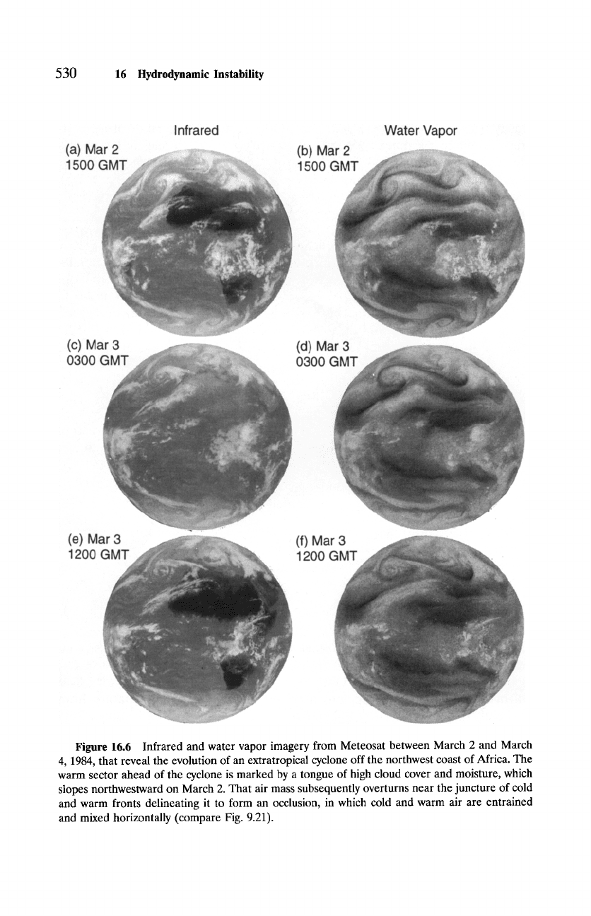
Infrared
(a) Mar 2 ............. .................. ............................. (b) Ma-"
1500 ( 1500 (
Water Vapor
(c) Ma-" (d) Ma-"
0300 ( 0300 (
(e) Ms - (f) Mar
1200 ~ 1200 (
Figure
16.6 Infrared and water vapor imagery from Meteosat between March 2 and March
4, 1984, that reveal the evolution of an extratropical cyclone off the northwest coast of Africa. The
warm sector ahead of the cyclone is marked by a tongue of high cloud cover and moisture, which
slopes northwestward on March 2. That air mass subsequently overturns near the juncture of cold
and warm fronts delineating it to form an occlusion, in which cold and warm air are entrained
and mixed horizontally (compare Fig. 9.21).
16.4
Nonlinear Considerations
531
potential energy into eddy kinetic energy enables a baroclinic system to in-
tensify and eventually attain finite amplitude. Finite horizontal displacements
then invalidate the linear description on which Eady's model is based and
which predicts exponential amplification to continue indefinitely--analogous
to vertical displacements under hydrostatically unstable conditions (Sec. 7.3).
Second-order effects then modify the zonal-mean state, which in turn limits
subsequent amplification of the baroclinic system.
As a baroclinic disturbance amplifies, horizontal displacements (e.g.,
Fig. 16.3b) become increasingly exaggerated. Warm tropical air is eventually
folded north of cold polar air, as is revealed by the distribution of potential
vorticity on March 2, 1984 (Fig. 12.10). Deformations experienced by those
air masses steepen potential temperature gradients separating warm and cold
air (e.g., Fig. 12.4), which intensifies the accompanying fronts. Continued ad-
vection leads to warm and cold air eventually encircling the low, with the
warm sector overturning at the junction of the warm and cold fronts. (Cloud
cover in Fig. 9.21 provides a textbook example.) The cyclone in Fig. 16.5 then
occludes,
with warm and cold fronts overlapping in the center of the system.
The occlusion actually develops when the surface trough (not shown) sepa-
rates from the junction of warm and cold fronts and deepens farther back
into the cold air mass (see, e.g., Wallace and Hobbs, 1977). This structure
marks the mature stage of the cyclone's life cycle because the surface trough
is then positioned beneath the upper-level trough, which eliminates the sys-
tem's westward tilt and hence its release of available potential energy--now
analogous to a neutral Eady mode with c~ > c~ C. Cold and warm air drawn
into the occlusion are then wound together and mixed horizontally.
Figure 16.6 shows sequences of IR and water vapor imagery while the
disturbance in Fig. 16.5 matures. At 1500 GMT on March 2 (Figs. 16.6a
and b), the cold front is approaching the warm front near their junction,
with the warm sector clearly defined. Twelve hours later, the 700-mb trough
has deepened (not shown). The warm sector in IR and water vapor imagery
(Figs. 16.6c and d) has then been sheared to the northwest, where cold dry
air is being entrained with warm moist air in the occlusion that has formed.
This process culminates in cold and warm air at the occlusion winding up
into a spiralbsimilar to behavior in a cylindrical annulus at high rotation
(compare Fig. 15.7f). By 1200 GMT on March 3 (Figs. 16.6e and f), air inside
the occlusion has wound up into a vortex, which is seen to separate from
the remaining warm sector to its south and east. Interleaving bands of cold
and warm air that are apparent in both cloud cover and moisture symbolize
efficient horizontal mixing. One day later (Figs. 1.15 and 1.23), that mass of
air has become nearly homogeneous. The 700-mb trough has then weakened
and high cloud cover that developed earlier through sloping convection is
dissipating. Only a broad spiral of equatorward-moving air remains, drawn
cyclonically around the now-diffuse anomaly of potential vorticity, in which
cold and warm air have been mixed.
532
16 Hydrodynamic Instability
Since 0 (more generally,
0e)
is conserved for individual air parcels, horizon-
tal mixing makes the potential temperature uniform and restores the thermal
structure to barotropic stratification. Baroclinic instability that was present ini-
tially has then been neutralized and no more potential energy is available for
conversion to eddy kinetic energy. This process is a direct counterpart of ver-
tical mixing by convection, which neutralizes hydrostatic instability (Sec. 7.3).
Strong modification of the mean state by unstable eddies contrasts sharply
with wave propagation under stable conditions. Parcel displacements are then
bounded, so the mean state remains largely unaffected outside regions of dis-
sipation, where wave activity is absorbed (Chapter 14).
The preceding treatment applies formally to a zonally symmetric mean state.
In practice, the results also lend insight into isolated regions of instability.
Amplified planetary waves in the Northern Hemisphere reinforce zonal-mean
vertical shear to produce a broken storm track that is marked by localized
jets east of Asia and North America (refer to Figs. 15.8a and 9.38). Strongly
baroclinic, the north Atlantic and north Pacific storm tracks are preferred sites
for cyclone development. Weaker planetary waves in the Southern Hemisphere
leave stratification there nearly uniform in longitude to produce a continuous
storm track. This enables cyclones there to assume a more regular distribution
than is observed in the Northern Hemisphere, one that occasionally resembles
baroclinic modes in a rotating annulus (see Figs. 2.10 and 15.7e).
The criteria for instability also have implications important to planetary
waves that have attained large amplitude. The situation is analogous to the
breaking of gravity waves when isentropic surfaces are overturned (Fig. 14.25).
High 0 is then folded underneath low 0 to make
~O/3z
< 0 and render
the region hydrostatically unstable. Convective mixing that ensues absorbs
organized wave motion and neutralizes the instability by driving
~O/3z
to
zero. Planetary waves of sufficient amplitude overturn the distribution of the
conserved property Q (Fig. 14.26). High potential vorticity folded poleward
of low potential vorticity then reverses
~Q/~y
locally to render the motion
dynamically unstable. At that point, the planetary wave field breaks. Small-
scale eddies that develop in the region of instability mix Q horizontally, which
absorbs organized wave motion and neutralizes the instability by driving
~Q/~y
to zero.
Suggested Reading
Atmospheric Science: An Introductory Survey
(1977) by Wallace and Hobbs
contains a synoptic analysis of the life cycle of extratropical cyclones.
Atmosphere-Ocean Dynamics
(1982) by Gill includes a nice comparison be-
tween Charney's (1947) model of baroclinic instability and the Eady model.
An Introduction to Dynamic Meteorology
(1992) by Holton provides a com-
plete description of baroclinic extratropical disturbances, their energetics, and
Problems
533
aspects surrounding their prediction. It also discusses the process of frontal
formation.
Middle Atmosphere Dynamics
(1987) by Andrews
et aL
discusses inertial insta-
bility in the tropical stratosphere and includes a description of planetary wave
breaking.
Problems
16.1. Derive equations (16.1).
16.2. Carry out the Lagrangian integration of (16.3) to relate an air parcel's
meridional displacement to its change of zonal velocity.
16.3. Provide an expression for the specific restoring force inside an inertially
unstable layer.
16.4. (a) At what latitudes is inertial instability favored? (b) Identify those re-
gions of the zonal-mean flow in Fig. 1.8 that would be most susceptible
to inertial instability.
16.5. Consider westerly flow that corresponds to an angular velocity
A(z) =
-~/(a
cos ~b), which varies with height but not with latitude. (a) Within
the framework of quasi-geostrophic motion and the Boussinesq approx-
imation, what sign of curvature must the velocity profile
A(z)
have for
shear instability to develop? (b) At what latitudes is shear instability
favored most if
A(z)
= E(z)-2~, with E < < 17
16.6. Obtain the lower boundary condition (16.6.4).
16.7. A wave packet approaches its critical line with phase speed Cr equal to
the real part of c in (16.8.1). Describe the wave packet's evolution in
the presence of weak dissipation if, under inviscid adiabatic conditions,
(a) c in (16.8.1) is real and (b) c in (16.8.1) is complex.
16.8. Obtain equations (16.9) and (16.10).
16.9. Recover the necessary condition (16.12).
16.10. Derive a necessary condition for instability of a quasi-geostrophic zonal
flow that is unbounded above and bounded below by a rigid surface of
constant height.
16.11. Derive a necessary condition for instability of a quasi-geostrophic zonal
flow that is bounded vertically at z = 0 and H by rigid walls.
16.12. (a) Show that, in the absence of rotation, criterion (1) in Sec. 16.2.2
recovers Rayleigh's condition for instability: a barotropic flow must
possess an inflection point in its interior. (b) Discuss the influence
rotation has on shear instability.
16.13. Why do midlatitude cyclones intensify during winter?
16.14. Obtain the dispersion relation (16.18) for Eady modes.
534
16 Hydrodynamic Instability
16.15. Demonstrate that the limiting structure of Eady modes for H ~ oo
has v' in quadrature with 0'.
16.16. Derive an expression for the shortwave cutoff
ac
for instability in the
Eady problem.
16.17. (a) Show that the maximum growth rate of Eady modes is achieved for
l = 0. (b) Express the growth rate of the fastest growing square Eady
mode (k = l) in terms of that of the fastest growing Eady mode (l = 0).
16.18. Show that, for the fastest growing Eady mode, the maximum slope of
motion in the meridional plane is only about half the slope of mean
isentropic surfaces.
16.19. Calculate the e-folding times of square Eady modes (k = l) for an f
plane at 45 ~
N 2 - 10 -4
S -2,
vertical shear of 3 m s -1 km -1, a rigid lid
at 10 km, and for zonal wavenumbers 1-8.
16.20. Within the framework of an initial value problem, describe the structure
and evolution predicted by the Eady model if the flow in Problem 15.19
is initialized with random structure having a broad wavenumber spec-
trum (a) under inviscid adiabatic conditions, (b) in the presence of
linear dissipation 3 with a timescale equal to the shortest e-folding time
of zonal wavenumber 2 under inviscid adiabatic conditions and (c) in
the presence of linear dissipation with a timescale equal to the shortest
e-folding time of zonal wavenumber 4 under inviscid adiabatic condi-
tions.
16.21. Meridional components of the eddy momentum flux
u'v'
and group
velocity %y vanish for Eady modes. Why?
16.22. Show that the eddy heat flux v'0' is positive and independent of height
for Eady modes.
16.23. Use the Eady problem to explain (a) why midlatitude cyclones develop
and track along the jet stream, (b) how baroclinic instability would be
altered if the jet were displaced equatorward and (c) where the storm
tracks should be positioned in relation to the time-mean motion in
Fig. 1.9.
16.24. Precipitation inside cyclones often assumes a banded structure. Discuss
this feature in relation to the evolution in Fig. 16.6 and the correspond-
ing distribution of potential vorticity
Qg.
16.25. Consider an idealized atmosphere in which the circulation is described
by the barotropic zonal flow
K(y) = -U cos(24~),
3Rayleigh friction and Newtonian cooling of the same timescale.
Problems
535
where U = 0.55~a. (a) Characterize the inertial stability of this flow as
a function of latitude. (b) Describe the zonal-mean circulation toward
which inertial instability will drive the flow.
16.26. Discuss the relationship of barotropic and baroclinic instability to strat-
ification (Sec. 12.2.1).
16.27. Unlike extratropical cyclones, tropical cyclones are driven by latent heat
release. Suppose a typhoon drifts poleward from the ITCZ. (a) De-
scribe its evolution as it migrates over colder sea surface temperatures.
(b) What structure of midlatitude westerlies will allow it to sustain it-
self?
Chapter 17
The Middle Atmosphere
Above the tropopause, the horizontal gradient of heating is generally weak
enough to leave the thermal structure close to barotropic stratification. There-
fore, baroclinic instability generated through local conversion of available po-
tential energy does not play an essential role in the stratosphere. Further,
strong westerlies in the winter stratosphere and easterlies in the summer
stratosphere trap baroclinic disturbances generated in the troposphere, lim-
iting their presence in the stratosphere to a neighborhood of the tropopause.
These features leave the circulation in the stratosphere much smoother than
in the troposphere (Fig. 1.10). However, planetary waves propagate through
strong westerlies of the polar-night jet (Sec. 14.5.2). Vertical growth enables
planetary waves to disturb the polar vortex and, during strong amplifica-
tions, to disrupt the circumpolar flow completely. Air then moves freely be-
tween tropical and polar regions, where it experiences sharply different ra-
diative environments. Global-scale disturbances like the one in Fig. 1.10a
play a key role in establishing mean distributions of motion and chemical
constituents.
With convection inhibited by strong static stability, the energy budget of the
stratosphere is dominated by radiative transfer, so it generally remains closer
to radiative equilibrium than the troposphere (Fig. 8.24). The radiative energy
budget is controlled by shortwave (SW) heating due to ozone absorption in the
Hartley and Huggins bands (Sec. 8.3.1) and longwave (LW) cooling due to CO2
emission to space at 15/zm. Ozone thus determines the thermal structure of
the middle atmosphere. Since this controls the circulation through hydrostatic
and geostrophic equilibrium, ozone figures indirectly in much of the observed
behavior of the middle atmosphere.
17.1 Ozone Photochemistry
The simplest treatment of ozone photochemistry is attributed to Chapman
(1930). Consider a pure oxygen atmosphere, the composition of which is gov-
erned by the following reactions
536
17.1
Ozone Photochemistry
537
02 +
hv
~ O + O (J2), (17.1.1)
0+0 2 -+-M --+ 0 3 -~-M
(k2), (17.1.2)
O + 03 ~ 202 (k3), (17.1.3)
03 +
hu --+
02 + O (J3), (17.1.4)
where the rate coefficients indicated parenthetically to the right character-
ize the speeds of individual reactions. ~ Reactions (17.1.1) and (17.1.4) de-
scribe photodissociation or
photolysis
of O2 by ultraviolet (UV) radiation in
the Herzberg continuum near 242 nm and of 03 in the Hartley and Huggins
bands near 310 nm, (17.1.4), operating at all wavelengths shorter than 1/xm.
Reactions (17.1.2) and (17.1.3) describe recombination of O2 and 0 3 with O.
The molecule M represents a third body needed to conserve momentum and
energy in the recombination of O and O2. Atomic oxygen produced by pho-
tolysis of ozone in (17.1.4) recombines immediately with molecular oxygen in
(17.1.2) to reform ozone. Hence, those reactions constitute a closed cycle in
O and 03 that absorbs UV radiation efficiently.
17.1.1 The Chemical Family
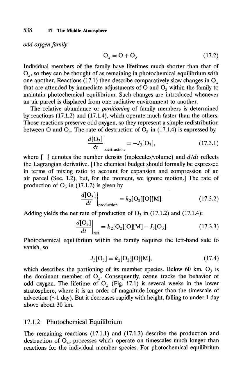
The rate coefficients determine the photochemical lifetimes of these species
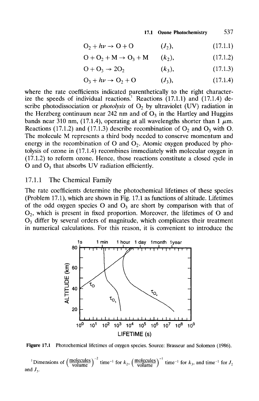
(Problem 17.1), which are shown in Fig. 17.1 as functions of altitude. Lifetimes
of the odd oxygen species O and 03 are short by comparison with that of
O2, which is present in fixed proportion. Moreover, the lifetimes of O and
03 differ by several orders of magnitude, which complicates their treatment
in numerical calculations. For this reason, it is convenient to introduce the
Figure 17.1
ls lmin 1hour 1day 1month 1year
80 I I I I
lit i I I tit
i
g
60
40
<
20
I tit
Ill Ill tit I I I ila Ill lit t
100 101 102 103 104 105 106 107 108 109
LIFETIME (s)
Photochemical lifetimes of oxygen species. Source: Brasseur and Solomon (1986).
1Dimensi~ ~ (m~ -2 volume
and J3.
time -1 for
k2,
(m~ 1'~-1
time -1 for
k3,
and time -1 for J2
538
17 The Middle
Atmosphere
odd oxygen family:
O x -- O -t- O 3. (17.2)
Individual members of the family have lifetimes much shorter than that of
O x, so they can be thought of as remaining in photochemical equilibrium with
one another. Reactions (17.1) then describe comparatively slow changes in Ox
that are attended by immediate adjustments of O and 03 within the family to
maintain photochemical equilibrium. Such changes are introduced whenever
an air parcel is displaced from one radiative environment to another.
The relative abundance or
partitioning
of family members is determined
by reactions (17.1.2) and (17.1.4), which operate much faster than the others.
Those reactions preserve odd oxygen, so they represent a simple redistribution
between O and 03. The rate of destruction of 03 in (17.1.4) is expressed by
d[O31
= -J3[O3], (17.3.1)
dt
destruction
where [ ] denotes the number density (molecules/volume) and
d/dt
reflects
the Lagrangian derivative. [The chemical budget should formally be expressed
in terms of mixing ratio to account for expansion and compression of an
air parcel (Sec. 1.2), but, for the moment, we ignore motion.] The rate of
production of 03 in (17.1.2) is given by
d[O3]
= 2[O21[O1[M1. (17.3.2)
dt
production
Adding yields the net rate of production of 03 in (17.1.2) and (17.1.4):
d[O3]
= 2[02I[O][MI - J3[03]. (17.3.3)
dt
net
Photochemical equilibrium within the family requires the left-hand side to
vanish, so
J3[O31- g2[O2l[Ol[Ml,
(17.4)
which describes the partioning of its member species. Below 60 km,
0 3
is
the dominant member of O x. Consequently, ozone tracks the behavior of
odd oxygen. The lifetime of Ox (Fig. 17.1) is several weeks in the lower
stratosphere, where it is an order of magnitude longer than the timescale of
advection (~1 day). But it decreases rapidly with height, falling to under 1 day
above about 30 km.
17.1.2 Photochemical Equilibrium
The remaining reactions (17.1.1) and (17.1.3) describe the production and
destruction of Ox, processes which operate on timescales much longer than
reactions for the individual member species. For photochemical equilibrium
17.1
Ozone Photochemistry
539
of the family as well, the net rate of production of [Ox] must also vanish. The
rate at which Ox molecules are produced in (17.1.1) is expressed by
a[~ i = 2,2[02], (17 1)
dt
production
whereas the rate they are destroyed in (17.1.3) is given by
d[Ox]
= -2k310][O 3 ]. (17.5.2)
dt
destruction
Adding yields the net rate of production of [Ox]
dIOx]
= 2J2[O2]- 2k3[O][O3]. (17.5.3)
dt
net
Photochemical equilibrium of O x then requires
J2[O2]- k3[O][O3].
(17.6)
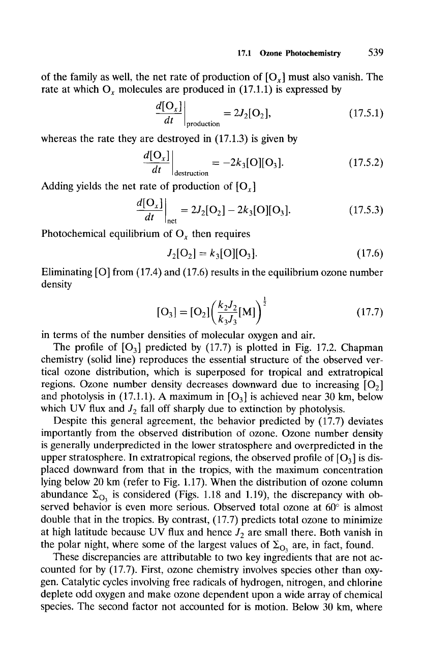
Eliminating [O] from (17.4) and (17.6) results in the equilibrium ozone number
density
1
( k2J 2k3J3 )2
[03] = [02]\ [M] (17.7)
in terms of the number densities of molecular oxygen and air.
The profile of [O3] predicted by (17.7) is plotted in Fig. 17.2. Chapman
chemistry (solid line) reproduces the essential structure of the observed ver-
tical ozone distribution, which is superposed for tropical and extratropical
regions. Ozone number density decreases downward due to increasing [02]
and photolysis in (17.1.1). A maximum in [O3] is achieved near 30 km, below
which UV flux and J2 fall off sharply due to extinction by photolysis.
Despite this general agreement, the behavior predicted by (17.7) deviates
importantly from the observed distribution of ozone. Ozone number density
is generally underpredicted in the lower stratosphere and overpredicted in the
upper stratosphere. In extratropical regions, the observed profile of [03] is dis-
placed downward from that in the tropics, with the maximum concentration
lying below 20 km (refer to Fig. 1.17). When the distribution of ozone column
abundance s is considered (Figs. 1.18 and 1.19), the discrepancy with ob-
served behavior is even more serious. Observed total ozone at 60 ~ is almost
double that in the tropics. By contrast, (17.7) predicts total ozone to minimize
at high latitude because UV flux and hence J2 are small there. Both vanish in
the polar night, where some of the largest values of s are, in fact, found.
These discrepancies are attributable to two key ingredients that are not ac-
counted for by (17.7). First, ozone chemistry involves species other than oxy-
gen. Catalytic cycles involving free radicals of hydrogen, nitrogen, and chlorine
deplete odd oxygen and make ozone dependent upon a wide array of chemical
species. The second factor not accounted for is motion. Below 30 km, where
