Morris & Fan. Reservoir Sedimentation Handbook
Подождите немного. Документ загружается.

LOÍZA RESERVOIR CASE STUDY 20.5
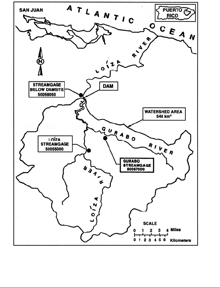
FIGURE 20.5 Location map of Loíza watershed USGS, gage stations, and reservoir.
20.3 SEDIMENTATION
20.3.1 Sediment Yield
Sediment yields in Puerto Rico are high, typically around 1000 to 2000 t/km
2
/yr, as
illustrated in Table 20.1 which is based on data from reservoir surveys, corrected for trap
efficiency by Brune's curve, and on estimated values of deposit bulk density. Despite
intensive urban development within the watershed, the specific sediment yield from the
Loíza watershed is the lowest of all island reservoirs, probably because of the lower
slopes in the broad and gently sloping valley along Rio Gurabo. However, because of its
small hydrologic size, the reservoir experiences a high 1.2 percent annual rate of storage
loss.
LOÍZA RESERVOIR CASE STUDY 20.6
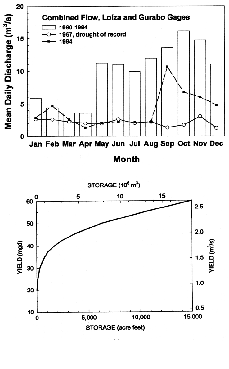
FIGURE 20.6 (Top) Seasonality of runoff at Loíza and Gurabo gage stations, as reported by
the USGS. (Bottom) Storage-yield curve for firm yield of Loíza Reservoir constructed from
gage data from 1959 through 1994. The drought of record occurred in 1967.

LOÍZA RESERVOIR CASE STUDY 20.7
TABLE 20.1 Sedimentation at Reservoirs in Puerto Rico
Site
Year
constructed
Original
volume,
10
6
m
3
Original
C:I ratio
Watershed
area, km
2
Specific
sediment
yield,
t
3
/km
2
/1yr
Annual
storage
loss, %
Caonillas 1948 59.0 0.36 211.4 659 0.3
Luchetti 1952 18.2 0.86 44.8 2651 0.6
Carite 1913 13.9 0.41 20.5 2026 0.3
Guayabal 1913 18.6 0.50 111.1 1817 0.9
Matrullas 1934 3.7 0.35 11.4 1534 0.5
Guineo 1931 2.3 0.49 4.1 1236 0.2
Garzas 1943 5.8 0.39 16.1 1159 0.3
Cidra 1946 6.6 0.55 22.3 1227 0.4
Dos Bocas 1942 37.5 0.09 310.8 1000 0.8
Patillas 1914 17.6 0.26 65.3 916 0.3
La Plata 1974 28.0 0.10 448.1 2331 1.3
Guajataca 1928 45.1 0.56 63.7 1637 0.1
Loco 1951 1.8 0.24 21.8 761 0.9
Loíza 1954 26.8 0.08 533.5 715 1.2
Source: Compiled from individual bathymetric studies performed by USGS in various years.
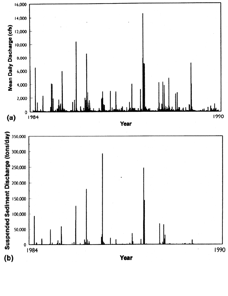
Streamflow and sediment yield throughout Puerto Rico are highly episodic, typical of
small watersheds where rainfall and runoff events are intense and of short duration. This
creates a runoff pattern characterized by low base flows punctuated by intense events of
short duration. Most of the sediment load entering Loíza reservoir is contributed by these
infrequent storm events. Sediment delivery is significantly more concentrated in time
than discharge (Fig. 20.7). Although rainy periods associated with storm systems may
last up to a week, even the largest runoff events have steep hydrographs and durations of
less than 24 hours, as illustrated by the September 5, 1960 flood caused by the passage of
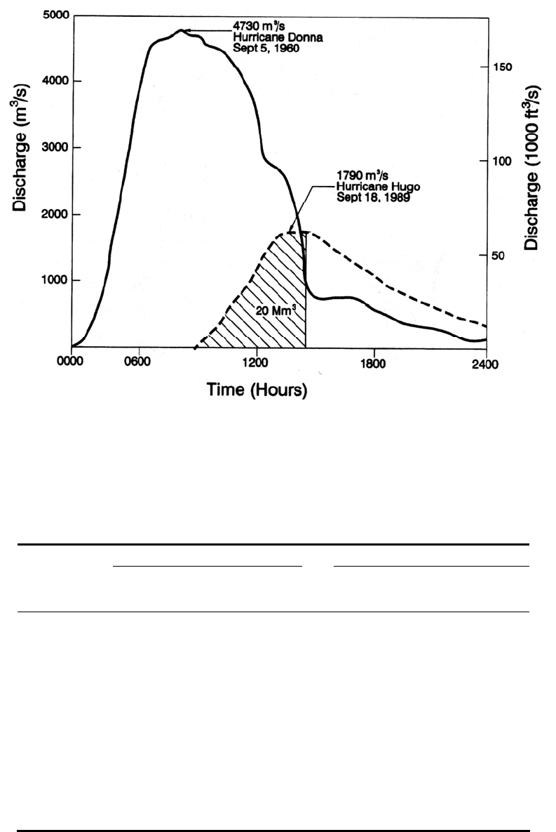
hurricane Donna, which produced the peak discharge of record (Fig. 20.8).
Continuous suspended sediment measurements at the USGS gage stations on the
Gurabo and Loíza Rivers, gaging 72 percent of the watershed above the dam, indicated
that 65 percent of the total 7-year (1984-1990) sediment inflow was contributed on only
10 days, and 17 percent of the total sediment inflow was attributed to a single storm
during that period (Table 20.2). This high concentration of sediment discharge in a short
period of time is typical of streams throughout Puerto Rico.
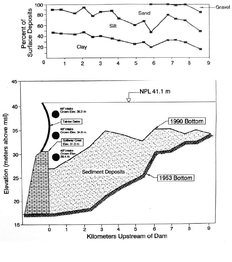
20.3.2 Sediment Deposits
Sediments deposited in Loíza Reservoir grade from clays to fine gravels moving
upstream from the dam. Deep borings revealed most of the sediment in the reservoir
consists of fines; only about 20 percent is sand-size, and a trace of gravel occurs
upstream. The lake is highly eutrophic because of nutrient inputs from both nonpoint and
point sources in the tributary watershed, and the organic content of sediments is high.
Shallow sampling of sediments by Quinones (1980) performed during a drought period in
1974 revealed an organic content (loss on irrigation) in the range of 8 to 12 percent over
most of the reservoir. However, the organic fraction averaged over the entire deposit
depth is significantly lower. Figure 20.9 illustrates the thalweg profile showing the
LOÍZA RESERVOIR CASE STUDY 20.8
the reservoir in the thalweg profile,
s confirmed by visual inspection at low pool level.
longitudinal pattern of sediment deposition and the grain size variation based on shallow
(less than 1 m) surface cores. The entire dead storage pool had been sedimented by 1990
and the remaining active pool volume was controlled by the crest gates. At Loíza
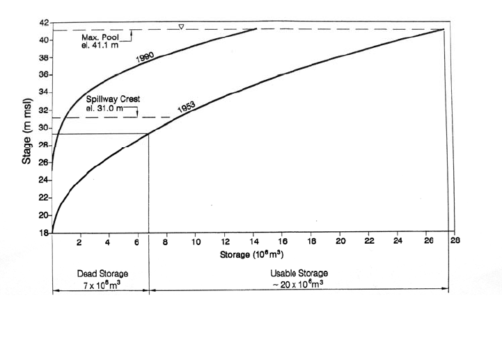
Reservoir, sediment deposits reduced the overall storage capacity in the reservoir,
prevented utilization of the lowest water supply intake, and elevated the top of the dead
pool, as illustrated by the shift in the stage-storage curves shown in Fig. 20.10. The
localized deposits about 3 km above the dam (Fig. 20.9) further inhibited the ability to
lower the pool without creating water quality problems by scouring anaerobic organic
sediments. There is no delta at the upstream limit of
FIGURE 20.7 Daily discharge of (a) water and (b) sediment from Loíza plus Gurabo streamgages
in U.S. customary units (plotted from USGS data).
a
LOÍZA RESERVOIR CASE STUDY 20.9
FIGURE 20.8 Discharge hydrographs at the Loíza dam site for hurricane Donna, the peak discharge
of record, and hurricane Hugo. The total usable reservoir volume of 20 Mm
3
(without sedimentation),
superimposed on the rising limb of the Hugo hydrograph, is significantly smaller than the volume
under either storm hydrographs (after P. R. Water Resources Authority, 1979 & USGS data)
TABLE 2
0.2 Total Daily Discharge of Water and Suspended Sediment, Ranked by
Sediment Load, Sum of Gurabo and Loíza Streamgages
Water discharge Suspended-sediment load
Daily rank
Daily
discharge, m
3
/s
Cumulative
percentage*
Daily load,
m
3
/s
Cumulative
percentage*
1 34,300 3.5 913,000 17.7
2 16,750 5.2 558,000 28.6
3 15,980 6.8 510,300 38.5
4 5,960 7.4 303,300 44.4
5 17,360 9.1 231,800 48.9
6 21,780 11.3 216,600 53.1
7 21,300 13.5 208,200 57.2
8 12,480 12,480 14.7 14.7 166,500 166,500 60.4 60.4
9 9 13,070 13,070 16.0 16.0 126,000 126,000 62.8 62.8
10 10 7,580 7,580 16.8 16.8 111,500 111,500 65.0 65.0
*Cumulative percent of the 7-year total.
Source: Computed from USGS data.
LOÍZA RESERVOIR CASE STUDY 20.10
FIGURE 20.9 Thalweg profile along Loíza Reservoir showing sediment deposit profile an
d
grain size variation. The location of the three 48-inch diameter potable water supply intakes
are also shown (adapted from PRASA,1992).
Deposits in the upper reservoir exposed during drought revealed a riverine-type cross
section and normally submerged bars of sandy sediment, but insignificant deposition of
coarse sand or gravels. The supply of coarse material has been reduced by the extensive
instream mining of sand and gravel in the river reaches above the dam. Bedrock is
exposed along much of the reach of Rio Loíza extending upstream from the dam, and
instream mining has lowered the bed of Rio Gurabo, its principal tributary.
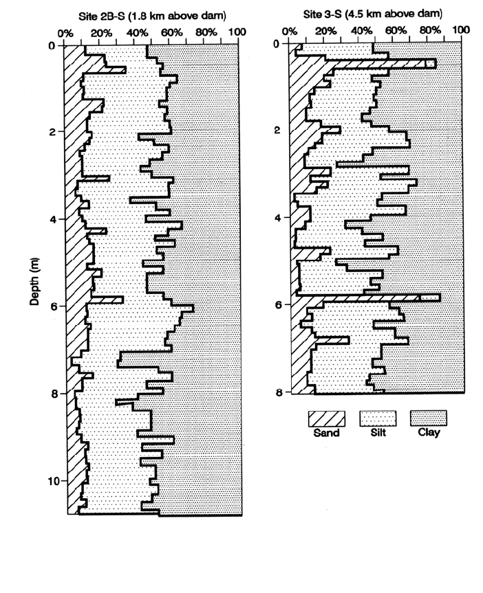
A geotechnical drilling rig was mounted on a barge and used to obtain fully
penetrating core samples. Layered deposits occur in the middle section of the reservoir
(Fig. 20.11) but the sediments closer to the dam are more uniformly fine-grained. The
sand layers represent coarse material transported deeper into the impoundment during
larger floods, and the fines above and below the sand lenses represent deposits from both
stratified and nonstratified flow during smaller runoff events, plus organic deposition
from primary production in the eutrophic lake (water hyacinth and algae).
LOÍZA RESERVOIR CASE STUDY 20.11
FIGURE 20.10 Change in the stage-storage relationship at Loíza Reservoir (adapted from
P
RASA, 1992).
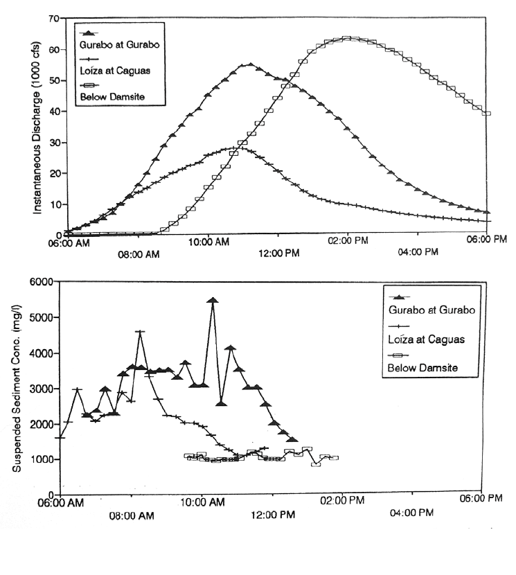
20.3.3 Sediment Discharge during Runoff Event
Discharge and suspended-sediment concentrations upstream and downstream of the
reservoir during a significant runoff event are illustrated in Fig. 20.12 with data from
hurricane Hugo collected at the three U.S. Geological Survey gage stations. Inflowing
sediment concentration in both the Gurabo and Loíza Rivers peaked before discharge
peaked and then dropped rapidly, with maximum inflow concentrations of 5.5 and 4.5
g/L at the Gurabo and Loíza gages respectively. However, concentrations below the dam
site remained relatively steady at about 1 g/L. The inflowing streams delivered most of
the sediment load and deposited it within the reservoir during the rising limb of the
hydrograph. Sediment yield was relatively low during the Hugo event, attributed by
Gellis (1993) to sediment trapping resulting from blockage of stream channels by wind-
blown woody debris. .
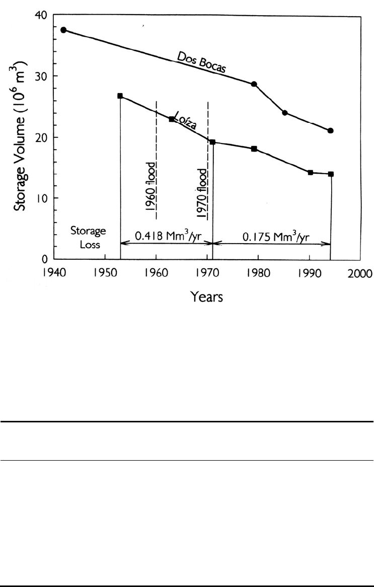
20.3.4 Rate of Storage Loss 20.3.4 Rate of Storage Loss
At Loíza Reservoir, the rate of storage loss may be computed by two methods: by
repeated bathymetric surveys (Fig. 20.13) and by measuring the difference in fluvial
sediment delivery at gage stations above and below the dam installed in 1984.
At Loíza Reservoir, the rate of storage loss may be computed by two methods: by
repeated bathymetric surveys (Fig. 20.13) and by measuring the difference in fluvial
sediment delivery at gage stations above and below the dam installed in 1984.
From fully penetrating cores and the 1991 bathymetry performed by the USGS, the
bulk densities of the reservoir sediments were determined as follows:
From fully penetrating cores and the 1991 bathymetry performed by the USGS, the
bulk densities of the reservoir sediments were determined as follows:
More than 5 km above dam, deposit volume = 2.0 Mm
3
, density = 960 kg/m
3
More than 5 km above dam, deposit volume = 2.0 Mm
3
, density = 960 kg/m
3
Less than 5 km above dam, deposit volume = 8.9 Mm
3
, density = 1200 kg/m
3
Less than 5 km above dam, deposit volume = 8.9 Mm
3
, density = 1200 kg/m
3
LOÍZA RESERVOIR CASE STUDY 20.12
FIGURE 20.11 Vertical profiles of sediment deposits at Loíza dam showing layering about 4.5
km above the dam, but more uniform fine-grained material closer to the dam (adapted from
P
RASA, 1992).
The average bulk density for all sediment deposits in the reservoir is 1,156 kg/m
3
.
Applied to the recent rate of storage loss of 0.175 Mm
3
/yr (Fig. 20.13), this bulk density
corresponds to the trapping of 202,000 t/yr of sediment in the reservoir.
Suspended sediment data from USGS gages at Gurabo, Loíza, and below dam site
(located as in Fig. 20.5) are summarized in Table 20.3 for calendar years 1987-1994, the
period with suspended sediment data for all three locations. Because the Caribbean wet
season extends from September through November, data are presented in calendar years
rather than the U.S. water year used by the USGS, which ends September 30. The bed
load in this system is not large, and load computations based on suspended load should
give a rather accurate estimate of the total sediment inflow into the reservoir.
LOÍZA RESERVOIR CASE STUDY 20.13
FIGURE 20.12 Hydrographs of runoff (top), and suspended-sediment concentration (bottom)
registered at USGS gage stations during hurricane Hugo. See Fig. 20.5 for gage locations.
The area tri
butary to the Loíza and Gurabo streamgages comprises 72 percent of the
watershed tributary to the dam, making it necessary to adjust the sediment inflow at these
two gage stations to include the ungaged area tributary to the dam. Because the ungaged
area is primarily steep lands, much of which drains directly into streams tributary to the
reservoir itself, and because portions of the ungaged area are affected by urban
development which can generate high sediment loads, it seems logical to adjust the gaged
sediment yield by a factor of 1.39. based on the ratio of total to gaged watershed areas.
However, on the basis of water yield, adjusted for withdrawals at the dam, the below-dam
gage station plus diversions at the dam account for only 110 percent of the inflow at the
upstream gages, for an adjustment factor of 1.10 for the total load entering the reservoir.
The values in Table 20.3 have been computed by using the adjustment factor of 1.10 to
determine sediment inflow, from which sediment discharge below the dam is subtracted,
to compute average sediment trapping of 433,700 t/yr. This rate of sediment accumula-
tion based on fluvial data is more than double the rate of accumulation based on bathy-
metric measurements, despite using the lower adjustment factor and ignoring bed load.
LOÍZA RESERVOIR CASE STUDY 20.14
FIGURE 20.13 Trends in storage loss at Loíza and Dos Bocas Reservoirs, Puerto Rico, based
on repeated bathymetric surveys. Both reservoirs are in north coast watersheds (data from Webb
and Soler-Lopez, 1997; Webb and Gomez-Gomez,1994).
TABLE 2
0.3 Suspended Sediment Trapped in Loíza Reservoir Based on USGS Fluvial
Gage station Data
Calendar
year
Loíza
load, t/yr
Gurabo
load, t/yr
Adjusted
load, t/yr
Release
below
dam, t/yr
Total
trapped,
t/yr
Trap
efficiency,
%
1987 557,505 1,656,516 2,435,423 244,244 2,191,179 90
1988 251,341 134,633 424,572 63,925 360,647 85
1989 117,253 201,103 350,191 73,829 276,362 79
1990 73,820 25,232 108,957 14,148 94,809 87
1991 46,337 15,317 67,819 15,726 52,093 77
1992 373,616 46,769 462,423 157,273 305,149 66
1993 135,625 41,528 194,869 64,376 130,493 67
1994 51,258 11,198 68,702 9,857 58,845 86
Source: Computed from USGS fluvial gage station data.