Houze Robert A., Jr. Cloud Dynamics
Подождите немного. Документ загружается.

9.2 The Squall Line with Trailing Stratiform Precipitation 389
9.2.3.7 Vertical Vorticity in the Stratiform Region
The vertical vorticity
~
[defined in (2.56)] exhibits interesting behavior in the
stratiform region. Often a
center
of cyclonic vorticity forms in association with the
stratiform precipitation zone. Two observed examples are shown in Fig. 9.49 and
Fig. 9.50. A simulation with a mesoscale model of the type described in Sec.
9.2.3.6 shows a similar behavior (Fig. 9.51). The cyclonic vorticity maximum is
often observed to be
near
the back edge of the stratiform precipitation rather than
in the center
of
the stratiform region. However, this is not true for the model
example in Fig. 9.51, and the exact location of the vorticity center and other
details of the vorticity pattern vary from case to case.
262
Observations indicate that the development of the vorticity center in the trail-
ing stratiform region is especially strong and deep in the asymmetric type of
squall-line structure illustrated in Figs. 9.9b and 9.14b. The asymmetric structure
of the precipitation pattern is evidently in part a consequence of the vorticity
maximum. The results of one study of this type of vorticity center are indicated
schematically in Fig. 9.52. Analysis of the observed wind field shows that the
vertical vorticity
~
was intense at midstorm levels where strong rear inflow and
convergence existed; thus, stretching appears to have been the dominant mecha-
nism for intensifying the vorticity. A vorticity center of the observed strength
could have been produced from the planetary vorticity alone in
-1.5
h. Pre-
existing relative vorticity in the inflow current, such as might be associated with a
short-wave trough in the westerlies, would accelerate the process. The short spin-
up time helps explain why these mesoscale vortices are common features of the
midlevel convergent layer in the trailing stratiform regions of squall lines. The
strong
rear
inflow observed in the case shown in Fig. 9.52 was quite dry and
characterized by low
(Je, and the strong midlevel vorticity in that case was associ-
ated with convergence into the mesoscale downdraft. The downdraft region was
indeed dominated by cyclonic vorticity. The rear inflow air appears to have ob-
262 For a concise review of mesoscale vortex development in squall lines with trailing stratiform
regions, see Sec. I of Brandes (1990). Zhang and Fritsch (1987, 1988a,b) and Chen and Frank
(1992)
discuss the vortex development in model simulations of mesoscale convective systems.
Figure 9.47 Rear inflow in the tropical squall line shown in Figs. 9.7, 9.8, and 9.20. (a) Low-level
radar reflectivity pattern. Superimposed circles denote locations of wind profiles shown in (b). Profiles
show horizontal wind component normal to the leading convective line seen as the zone of intense
echoes in (a). Positive values denote flow from rear to front of the storm. (From Chong et al.,
1987.
Reprinted with permission from the American Meteorological Society.)
Figure 9.48 Mesoscale model simulation of the squall line with trailing stratiform region illustrated
in Figs. 9.15, 9.18, 9.31, 9.34, 9.40, 9.41, 9.43, 9.44, 9.45, 9.48, 9.53, and 9.54. Vertical cross section
normal to the squall line. Leading edge of the squall line at the ground is indicated by SL. Horizontal
flow perpendicular and relative to the squall line is indicated in m
S-I.
Positive values are directed from
rear to front (left to right). In (b) a model result with no diabatic heating has been subtracted from the
total result shown in (a). (From Zhang and Gao, 1989. Reprinted with permission from the American
Meteorological Society.)
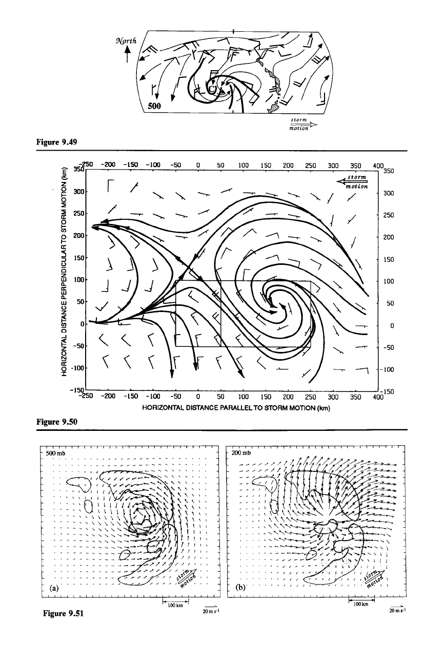
Figure 9.49
storm
motion>
Figure 9.51
20ms·
1
100 Ion
20ms·\
9.2 The Squall Line with Trailing Stratiform Precipitation
391
tained horizontal vorticity by baroclinic generation [B
x
and B\' in (2.57) and (2.58)]
upstream to the south and west of the vorticity center where warm air lay to the
right facing downwind. As the inflow was tilted by the downdraft while it pene-
trated toward the
center
of
the stratiform region, its horizontal vorticity was tilted
into the vertical [second term on the right in (2.59)] and concentrated by conver-
gence [first term on the right in (2.59)].
The vorticity pattern associated with the symmetric type of squall-line struc-
ture (Fig. 9.9a) has been documented in detail for one case. The horizontal pattern
of vertical vorticity at midlevels was one of alternating bands: cyclonic in the
convective region, anticyclonic in a zone
just
behind the convective region, and
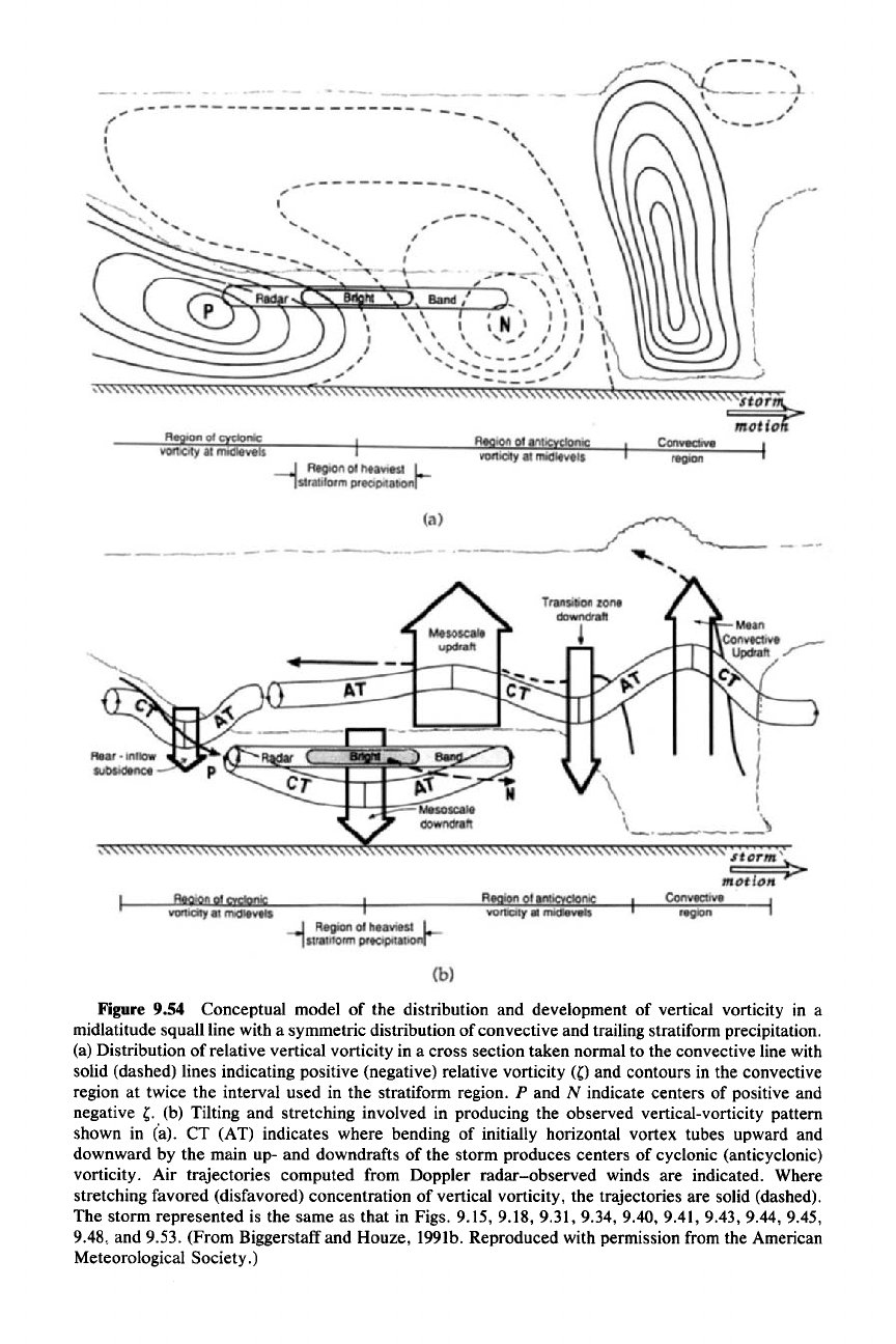
cyclonic at the back edge of the stratiform region (Fig. 9.53). A conceptual model
illustrating how this structure developed is shown in Fig. 9.54. The vortex tubes
shown were initially horizontal. The storm was located in a sheared environment
characterized by along-line wind that increased (in the into-the-page sense in Fig.
9.54) with height.
The
banded vorticity pattern is accounted for by the tilting and
stretching
of
the environmental vorticity. The tilting by the main up- and down-
drafts of the storm bent the vortex tubes upward and downward. Selected trajec-
tories (computed from Doppler
radar-observed
winds) are indicated. Where
stretching favored concentration of vertical vorticity the trajectories are solid, and
where concentration was disfavored they are dashed. The cyclonic vorticity in the
convective region was produced by the tilting on the forward side of the main
convective updraft.
The
anticyclonic vorticity zone immediately behind the con-
vective line was produced by tilting on the trailing side of the main convective
updraft and by tilting on the forward sides of the transition zone and mesoscale
downdrafts. The cyclonic vorticity maximum at the back edge of the stratiform
Figure 9.49 Analysis of the flow shown by a composite of rawinsonde data obtained in the vicinity
of a squall line with a trailing stratiform region in west Texas. Streamlines are superimposed on
features of the low-level radar reflectivity field. The convective echo cores in the squall line are
shaded. The curved lines trace the positions of lines of more intense echo embedded in the stratiform
precipitation region. The C marks the
"center
of curvature" of the echo bands. (From Leary and
Rappaport, 1987. Reprinted with permission from the American Meteorological Society.)
Figure 9.50 Composite analysis of the mesoscale component of the wind at the 650-mb level of a
tropical squall-line system. The smaller rectangle is the region within which the leading convective line
was found on radar. The larger rectangle is the region in which trailing stratiform precipitation was
found. Winds from soundings and aircraft were analyzed objectively and the mesoscale component of
the flow shown here was deduced by applying a mesoscale bandpass filter to the data to suppress
larger- and smaller-scale wavelengths. A full wind barb represents 5 m
S-I.
A vortex is evident toward
the rear of the stratiform region. Other aspects of this storm are represented in Figs. 9.42 and 9.59.
(From Gamache and Houze, 1985. Reproduced with permission from the American Meteorological
Society.)
Figure 9.51 Mesoscale model result showing vortex formation in the trailing stratiform region of a
midlatitude squall line. Relative wind vectors in a coordinate system moving at the speed of the vortex.
Shading shows areas of stratiform (i.e., model-resolved) precipitation. Contours enclose regions of
convective (parameterized) precipitation. (a) 500 mb and (b) 200 mb. (From Chen, 1990.)

392
9 Mesoscale Convective Systems
STRATIFORM
RAIN
<,
\
REAR INFLOW JET
UPDRAFT
- LOWER TROPOSPHERIC FLOW
- MIDDLE TROPOSPHERIC FLOW
Figure 9.52 Schematic of the flow associated with an asymmetric type of squall-line system (as
described in Sec. 9.2.1 and Fig. 9.9) observed in Oklahoma. Scalloped areas represent precipitation.
(From Brandes, 1990. Reprinted with permission from the American Meteorological Society.)
300
240
E 180
~
w
~
0
120
z
motio
~
60
en
is
...J
~
0
0
Z
0
N
-60
a:
0
I -120
-180
-240
Figure 9.53 The pattern of vertical vorticity at the 675-mb level in a midlatitude squall-line
system. Vorticity is contoured every I x 10-
4
S-I
with negative values dashed. Background shading
indicates the low-level radar echo (i.e., rainfall) pattern. Dark shading shows the convective rain area,
the light shading the stratiform area, and the intermediate shading the region of heavier stratiform rain.
The storm in which the data were taken is the same as that represented in Figs. 9.15, 9.18, 9.31, 9.34,
9.40, 9.41, 9.43, 9.44, 9.45, 9.48, and 9.54. (From Biggerstaff and Houze, 1991a. Reproduced with
permission from the American Meteorological Society.)
region
Convective
,..r-----.~
,-----
....
/
'\
'
_/
'f----- -
_-l.
I
, /
" /
vorticity
at
midlevels
Re ionof antic clonic
Re ion of c clonic
---.J
Region
of
heaviest
L
1
stratiform
precipitationf
vorticity
at
midlevels
----------------------
r "
---
I
I
I
\
\
,
,
'-,
"
'~",,-
" "-
"-
~
'-
------~-
.'",
---
Figure 9.54 Conceptual model of the distribution and development of vertical vorticity in a
midlatitude squall line with a symmetric distribution of convective and trailing stratiform precipitation.
(a) Distribution of relative vertical vorticity in a cross section taken normal to the convective line with
solid (dashed) lines indicating positive (negative) relative vorticity
Wand
contours in the convective
region at twice the interval used in the stratiform region.
P and N indicate centers of positive and
negative
,.
(b) Tilting and stretching involved in producing the observed vertical-vorticity pattern
shown in (a). CT (AT) indicates where bending of initially horizontal vortex tubes upward and
downward by the main up- and downdrafts of the storm produces centers of cyclonic (anticyclonic)
vorticity. Air trajectories computed from Doppler radar-observed winds are indicated. Where
stretching favored (disfavored) concentration of vertical vorticity, the trajectories are solid (dashed).
The storm represented is the same as that in Figs. 9.15, 9.18, 9.31, 9.34, 9.40, 9.41, 9.43, 9.44, 9.45,
9.48, and 9.53. (From Biggerstaff and Houze, 1991b. Reproduced with permission from the American
Meteorological Society.)
394 9 Mesoscale Convective Systems
precipitation region was formed by tilting and stretching in the downward rear
inflow at the back edge of the stratiform precipitation.
9.3 General Kinematic Characteristics of Mesoscale
Convective Systems
In Sec. 9.1 we saw that the mesoscale convective system exhibits a variety of
structures, as indicated by its pattern of precipitation. Although the pattern and
organization of the precipitation vary from case to case (e.g., Fig. 9.10), the large
area of rainfall of a mesoscale convective system is nearly always subdivided into
clearly identifiable convective and stratiform regions. In Sec. 9.2 we examined the
type of system in which the precipitation consists of a sharply defined leading line
of convective precipitation trailed by a region of stratiform precipitation (e.g., Fig.
9. lOa). We now consider the broader spectrum of mesoscale convective cloud
systems, including ones in which the precipitation exhibits other types of meso-
scale organizations (e.g., Fig. 9. lOb and c). In the remainder of this chapter, we
will examine the divergence and vorticity of the wind fields in and around meso-
scale convective systems of various types. Despite their diversity of structure,
these cloud systems exhibit rather similar gross patterns of divergence and vortic-
ity. These characteristics are important because they reflect how the mesoscale
convective systems are interacting with the larger-scale atmospheric circulation.
9.3.1 Divergence Associated with Mesoscale
Convective Systems
The vertical distribution of divergence in a mesoscale convective system whose
precipitation is organized into a convective and trailing stratiform region is illus-
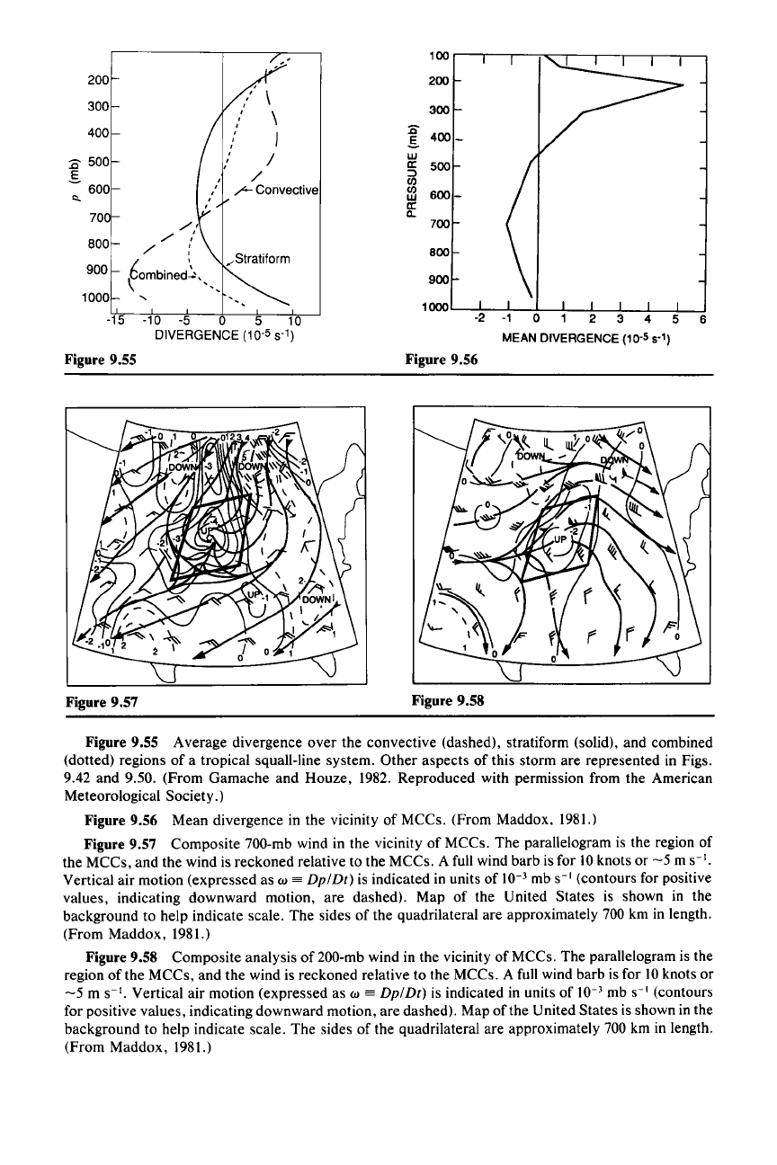
trated in Fig. 9.55. These profiles of divergence were determined for a storm of the
type shown conceptually in Fig. 9.13. The divergence averaged
over
the convec-
tive region is characterized by convergence in the lower troposphere and diver-
gence in the upper troposphere. In the stratiform region, the profile shows conver-
gence in the middle troposphere, with a maximum at about the 600-700-mb level,
with divergence at upper and lower levels.
263 The profile of net divergence for the
storm as a whole is the area-weighted sum of the convective and stratiform pro-
files.
It
shows weak divergence (positive in this case, but not significantly different
from zero) at low levels, where the divergence in the stratiform region tends to
cancel the convergence characterizing the convective line. The level of maximum
convergence in the net profile is thus elevated well above the surface. In this case,
it is found between 900 and 700 mb, where both the convective and stratiform
regions are convergent. The maximum divergence is at high levels, where both the
convective and stratiform regions are divergent.
263 These profiles are typical of mesoscale convective systems consisting of a leading line of con-
vective precipitation trailed by a stratiform rain area. See Houze (1989) for a comprehensive review.
100
200
200
300
\
\
300
400
I
:0
400
_
S.
:0
500 I
w
a:
500
.s
/
:::>
CI)
600
/-
Convective
a
600-
I:>.
a:
70
a..
,/,
700
800
,/
"
,/
:
",Stratiform
800
900
€ombined~""
900
1000
"
1000
-15 -10
-5
0 5 10
6
DIVERGENCE
(10-
5
st)
Figure 9.55
Figure 9.56
Figure 9.57
Figure 9.58
Figure 9.55 Average divergence
over
the convective (dashed), stratiform (solid), and combined
(dotted) regions of a tropical squall-line system. Other aspects of this storm are represented in Figs.
9.42 and 9.50. (From Gamache and Houze, 1982. Reproduced with permission from the American
Meteorological Society.)
Figure 9.56 Mean divergence in the vicinity of MCCs. (From Maddox, 1981.)
Figure 9.57 Composite 700-mb wind in the vicinity of MCCs. The parallelogram is the region of
the MCCs, and the wind is reckoned relative to the MCCs. A full wind barb is for 10knots or
-5
m
S-I.
Vertical air motion (expressed as w
==
Dp/Dt)
is indicated in units of 10-
3
mb
S-I
(contours for positive
values, indicating downward motion, are dashed). Map of the United States is shown in the
background to help indicate scale. The sides of the quadrilateral are approximately 700 km in length.
(From Maddox, 1981.)
Figure 9.58 Composite analysis of 200-mb wind in the vicinity of MCCs. The parallelogram is the
region of the MCCs, and the wind is reckoned relative to the MCCs. A full wind barb is for 10 knots or
-5
m
S-I.
Vertical air motion (expressed as w
==
Dp/Dt)
is indicated in units of 10-
3
mb
S-I
(contours
for positive values, indicating downward motion, are dashed). Map of the United States is shown in the
background to help indicate scale. The sides of the quadrilateral are approximately 700 km in length.
(From Maddox, 1981.)
396 9 Mesoscale Convective Systems
The divergence profiles in Fig. 9.55 are typical not only of the squall line with
trailing stratiform structure but also of mesoscale convective systems that exhibit
a wider variety of mesoscale organizations. To illustrate this fact, we now exam-
ine the largest of the mesoscale convective
systems-the
MCC, whose satellite-
observed cloud shield satisfies the criteria listed in Table 9.
I.
By focusing on these
large and long-lasting systems, we expect stronger and clearer kinematic signals.
There is evidence, however, that the types of mesoscale organization in smaller,
less intense mesoscale convective systems are qualitatively similar to those of
MCCS.264
Thus, much of what is learned from the MCCs should be applicable to
smaller mesoscale convective systems.
Mean kinematic characteristics of MCCs are shown in Figs. 9.56-9.59. The
mean divergence for the cloud cluster is shown by the solid curve in Fig. 9.56.
It
was calculated from a composite of the rawinsonde-measured winds in the vicinity
of cloud clusters. The composite wind fields at 700 and 200 mb are shown in Fig.
9.57 and 9.58. The cloud cluster location is the parallelogram. The divergence in
Fig. 9.56 is the average over the region of the parallelogram.
There is a strong qualitative similarity in the shape of the profile of net diver-
gence associated with the MCC and the shape of the curve of net divergence for
the squall line with trailing stratiform precipitation (cf. Figs. 9.55 and 9.56). As in
the case of the squall line with trailing stratiform precipitation, the mean MCC
divergence is approximately zero near the ground, where the strong convergence
in the boundary layer, where air rises into the bases of the convective downdrafts
at gust-front convergence lines, is offset in the mean by divergence associated
with the spreading of downdraft air below cloud. Thus, the net divergence over
the entire area of the MCC is near zero close to the surface. The strongest net
convergence is again found to be elevated well above the surface. In the MCC
profile, the maximum convergence is at 700 mb. Also similar to the squall line with
trailing stratiform precipitation, the MCC exhibits a strong peak of divergence at
high levels (200 mb). The strongly divergent character of the MCC winds at the
200-mb level is seen clearly in the streamline and isotach patterns of the composite
relative flow shown in Fig. 9.58. When the winds are filtered to remove the
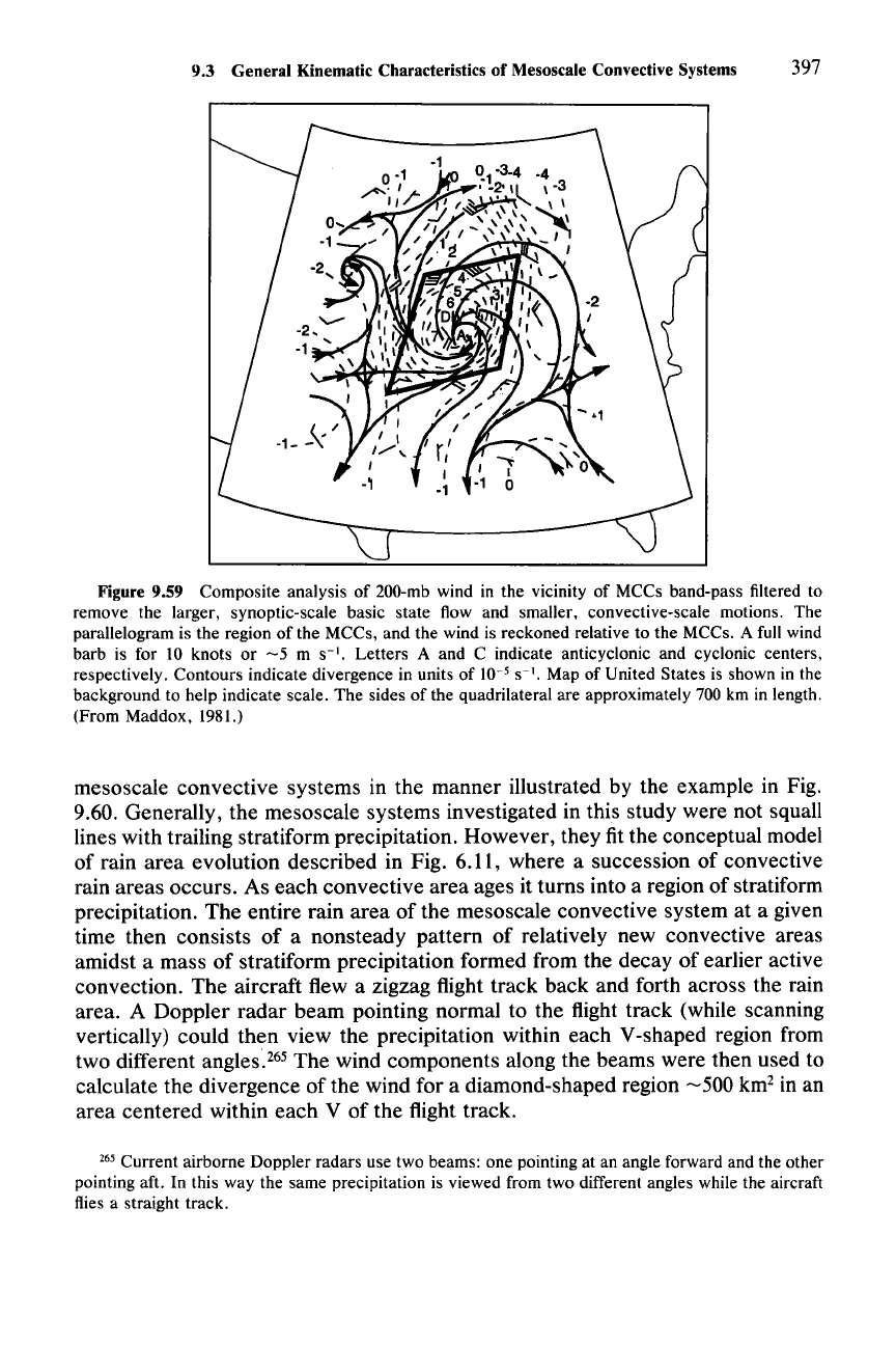
synoptic-scale basic state flow, the mesoscale divergence and anticyclonic out-
flow are even more striking (Fig. 9.59). At this level, both the convective region
and the stratiform region of a mesoscale convective system are characterized by
divergence, and the two components of the MCC reinforce to produce the strong
divergent signal on the mesoscale.
Further insight has been gained into the vertical profile of the divergence in
mesoscale convective systems by aircraft flights into mesoscale convective sys-
tems of the type that have a more highly varied internal structure than the squall
line with a trailing stratiform region. During a field experiment conducted over the
ocean north of Australia, an aircraft with a Doppler radar on board flew through
264 In a study of major rainstorms
over
Oklahoma during springtime over a 6-year period, Houze et
al. (1990) found no difference in the mesoscale rainfall structures of MCCs and weaker mesoscale
convective systems.
9.3 General Kinematic Characteristics of Mesoscale Convective Systems 397
Figure 9.59 Composite analysis of 200-mb wind in the vicinity of MCCs band-pass filtered to
remove the larger, synoptic-scale basic state flow and smaller. convective-scale motions. The
parallelogram is the region of the MCCs, and the wind is reckoned relative to the MCCs. A full wind
barb is for 10 knots or
-5
m
S-I.
Letters A and C indicate anticyclonic and cyclonic centers,
respectively. Contours indicate divergence in units of 10-
5
S-I.
Map of United States is shown in the
background to help indicate scale. The sides of the quadrilateral are approximately 700 km in length.
(From Maddox, 1981.)
mesoscale convective systems in the manner illustrated by the example in Fig.
9.60. Generally, the mesoscale systems investigated in this study were not squall
lines with trailing stratiform precipitation. However, they fit the conceptual model
of rain area evolution described in Fig. 6.11, where a succession of convective
rain areas occurs. As each convective area ages it turns into a region of stratiform
precipitation. The entire rain area of the mesoscale convective system at a given
time then consists of a nonsteady pattern of relatively new convective areas
amidst a mass of stratiform precipitation formed from the decay of earlier active
convection. The aircraft flew a zigzag flight track back and forth across the rain
area. A Doppler radar beam pointing normal to the flight track (while scanning
vertically) could then view the precipitation within each V-shaped region from
two different angles.
265
The wind components along the beams were then used to
calculate the divergence of the wind for a diamond-shaped region
-500
km
2
in an
area centered within each V of the flight track.
265 Current airborne Doppler radars use two beams: one pointing at an angle forward and the other
pointing aft. In this way the same precipitation is viewed from two different angles while the aircraft
flies a straight track.
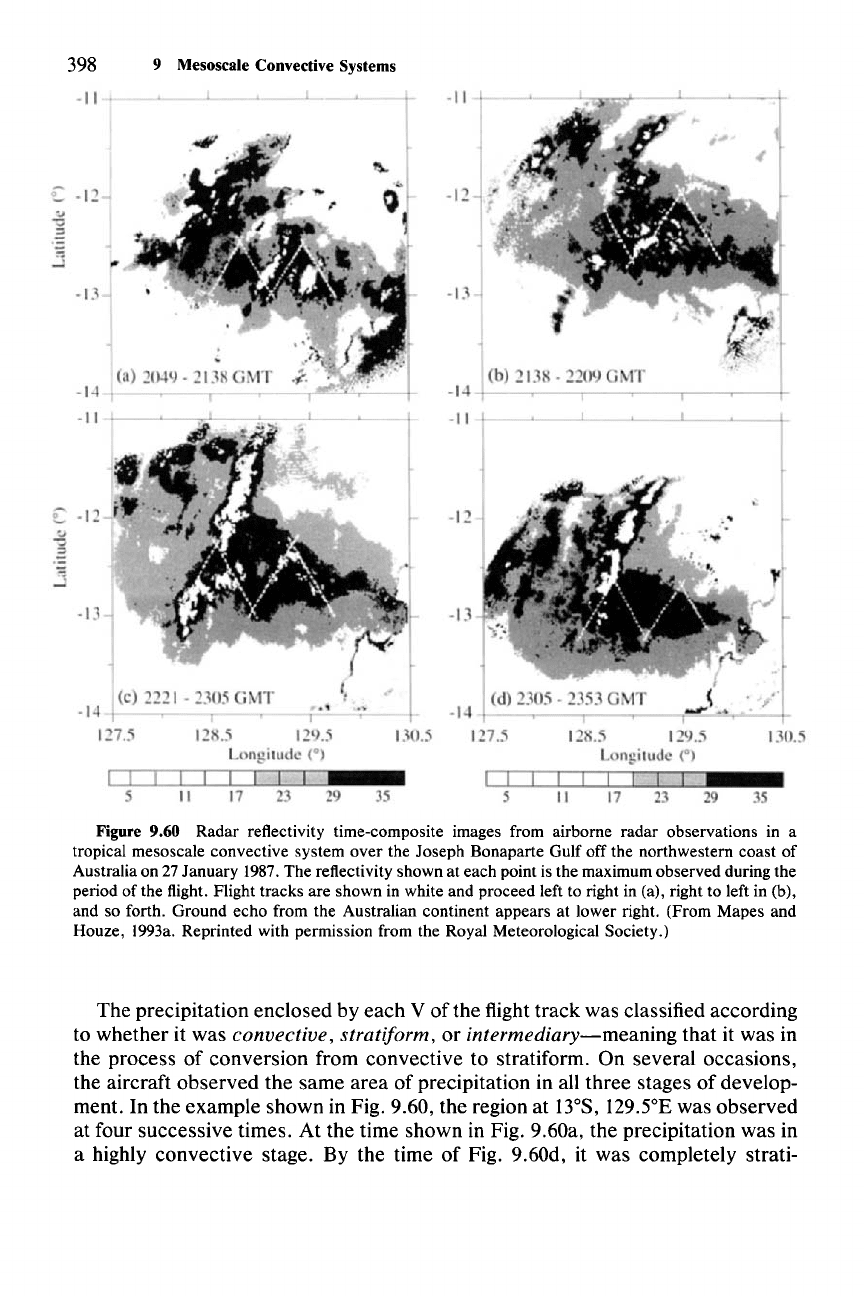
398 9 Mesoscale Convective Systems
Figure 9.60 Radar reflectivity time-composite images from airborne radar observations in a
tropical mesoscale convective system
over
the Joseph Bonaparte Gulf off the northwestern coast of
Australia on 27 January 1987. The reflectivity shown at each point is the maximum observed during the
period of the flight. Flight tracks are shown in white and proceed left to right in (a), right to left in (b),
and so forth. Ground
echo
from the Australian continent appears at lower right. (From Mapes and
Houze, 1993a. Reprinted with permission from the Royal Meteorological Society.)
The precipitation enclosed by each V of the flight track was classified according
to whether it was
convective, stratiform, or
intermediary-meaning
that it was in
the process of conversion from convective to stratiform. On several occasions,
the aircraft observed the same area of precipitation in all three stages of develop-
ment. In the example shown in Fig. 9.60, the region at
13°S,
129SE
was observed
at four successive times. At the time shown in Fig. 9.60a, the precipitation was in
a highly convective stage. By the time of Fig. 9.60d, it was completely strati-
