Houze Robert A., Jr. Cloud Dynamics
Подождите немного. Документ загружается.

10.1 General Features of Hurricanes 409
cial dropwindsondes and Doppler radar data obtained aboard a research aircraft.
In Fig. 10.5a, the wind
data
have been filtered to remove wavelengths less than
about 150 km near the
center
of the storm and 440 km in the outer portions of the
figure. This view emphasizes the large-scale flow pattern in which the storm is
embedded. The hurricane appears as a cut-off low in the tropical easterlies. In Fig.
1O.5b,
the analysis retains wavelengths down to about 16 km in the center of the
figure and down to about 44 km in the outer part of the figure. In this higher-
resolution analysis, the hurricane vortex itself is highlighted. The streamlines
show the boundary-layer air spiraling inward toward the center of the storm. The
isotachs (Fig. 10.5b) show an annular zone of maximum wind speed, called the
radius
of
maximum
wind, at
~20
km (0.18° latitude) from the storm center. The air
parcels spiraling inward tend to conserve their angular momentum (except for that
lost by friction).
The
radius of maximum wind is created when the inflowing air
abruptly slows down, converges, and turns suddenly upward in a ring of intense
convection, which produces the eyewal1. The radius of maximum wind thus
closely coincides with both the eyewall precipitation maximum and the maximum
updraft zone surrounding the eye of the storm. Inside the radius of maximum
wind, the wind speeds drop off almost immediately to nearly zero, and the vertical
air motion is downward, suppressing clouds and producing the characteristic hole
marking the eye in satellite imagery (Fig. 1.28).
A full dynamical explanation for the eye of the storm is presently lacking.
Discussions
of
the problem are given in
other
texts.P? Since the eye dynamics are
not directly relevant to the cloud and precipitation structure of the hurricane, we
will not pursue this subject here.
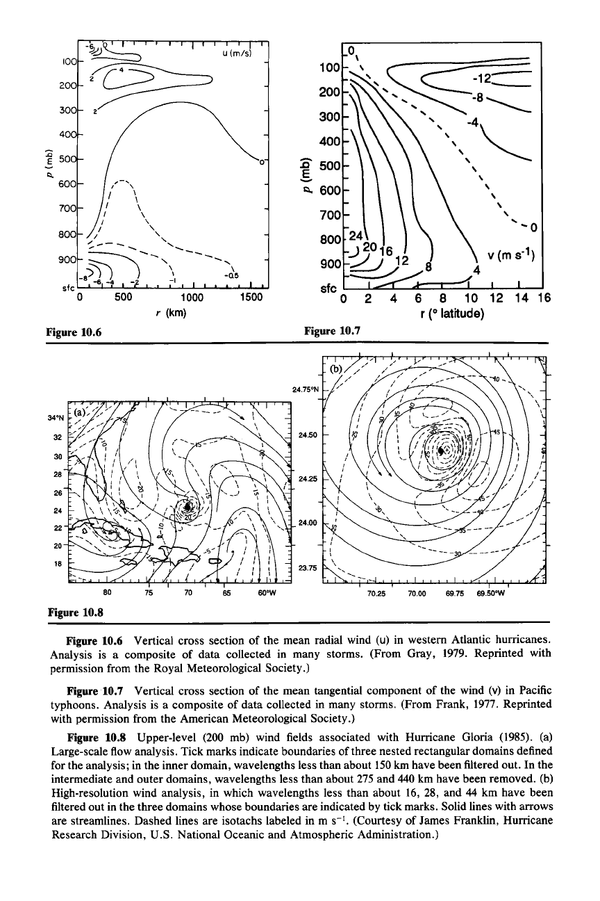
Vertical cross sections of the mean radial (u) and tangential (v) components of
the wind in a hurricane are shown in Figs. 10.6 and 10.7, which are composites of
data collected in many storms. Most evident in the radial wind field (Fig. 10.6) is
the increase in the inward-directed component at low levels as one approaches the
storm center. Strong radial outflow is evident at the top of the storm, at about the
200-mb level. In the tangential wind field (Fig. 10.7), it is evident that the strongest
wind at the radius
of
maximum wind is found in the lower troposphere, at about
the 850-mb level (or about 1.5 km above the sea surface).
The pattern
of
horizontal winds at 200 mb, in the outflow layer near the top of
the hurricane, is shown in Fig. 10.8 for Hurricane Gloria, whose low-level flow
was illustrated in Fig. 10.5. The large-scale wind (Fig.
1O.8a)
illustrates that al-
though the hurricane outflow is strong, it is not very symmetric.
It
tends to occur
in one or two anticyclonic outflow
jets.
In the case shown, there is an outflow
channel to the northeast
of
the storm center.
It
is also evident that at this high
altitude the cyclonic vortex core is still evident near the storm center. The cy-
clonic flow changes to anticyclonic
-100
km from the storm center. The details of
the cyclonic flow near the center
of
the storm are illustrated by the high-resolution
analysis in Fig. 10.8b.
The strong low-level convergence in the eyewall and strong outflow aloft must
be balanced by strong upward motion. The broad-scale pattern
of
vertical motion
269 See Anthes (1982, pp. 34-36) and Palmen and Newton (1969, pp. 482-491).
14 16
:El
500
§.
Q, 600
700
800 24
:J 20 16
900
2'
)
,)2
sfc
L....L...:::::::::(:......t:::::~::::l_l--L--.J
a 2 4
o
1500
U (rrv/s)
1000
r
(km)
500
200
100
300
40
1
50
Figure 10.6
Figure 10.7
32
24.50
30
28
24.25
28
24
22
24.00
20
18
23.75
80
75
70
65
6O'W
Figure 10.8
70.25 70.00
69.75 69.50'W
Figure 10.6 Vertical cross section of the mean radial wind (u) in western Atlantic hurricanes.
Analysis is a composite of data collected in many storms. (From Gray, 1979. Reprinted with
permission from the Royal Meteorological Society.)
Figurel0.7
Vertical cross section of the mean tangential component of the wind (v) in Pacific
typhoons. Analysis is a composite of data collected in many storms. (From Frank, 1977. Reprinted
with permission from the American Meteorological Society.)
Figure 10.8 Upper-level (200 mb) wind fields associated with Hurricane Gloria (1985). (a)
Large-scale flow analysis. Tick marks indicate boundaries of three nested rectangular domains defined
for the analysis; in the inner domain, wavelengths less than about 150
km have been filtered out. In the
intermediate and outer domains, wavelengths less than about 275 and 440 km have been removed. (b)
High-resolution wind analysis, in which wavelengths less than about 16, 28, and 44 km have been
filtered out in the three domains whose boundaries are indicated by tick marks. Solid lines with arrows
are streamlines. Dashed lines are isotachs labeled in m
S-I.
(Courtesy of James Franklin, Hurricane
Research Division, U.S. National Oceanic and Atmospheric Administration.)
10.1 General Features of Hurricanes
411
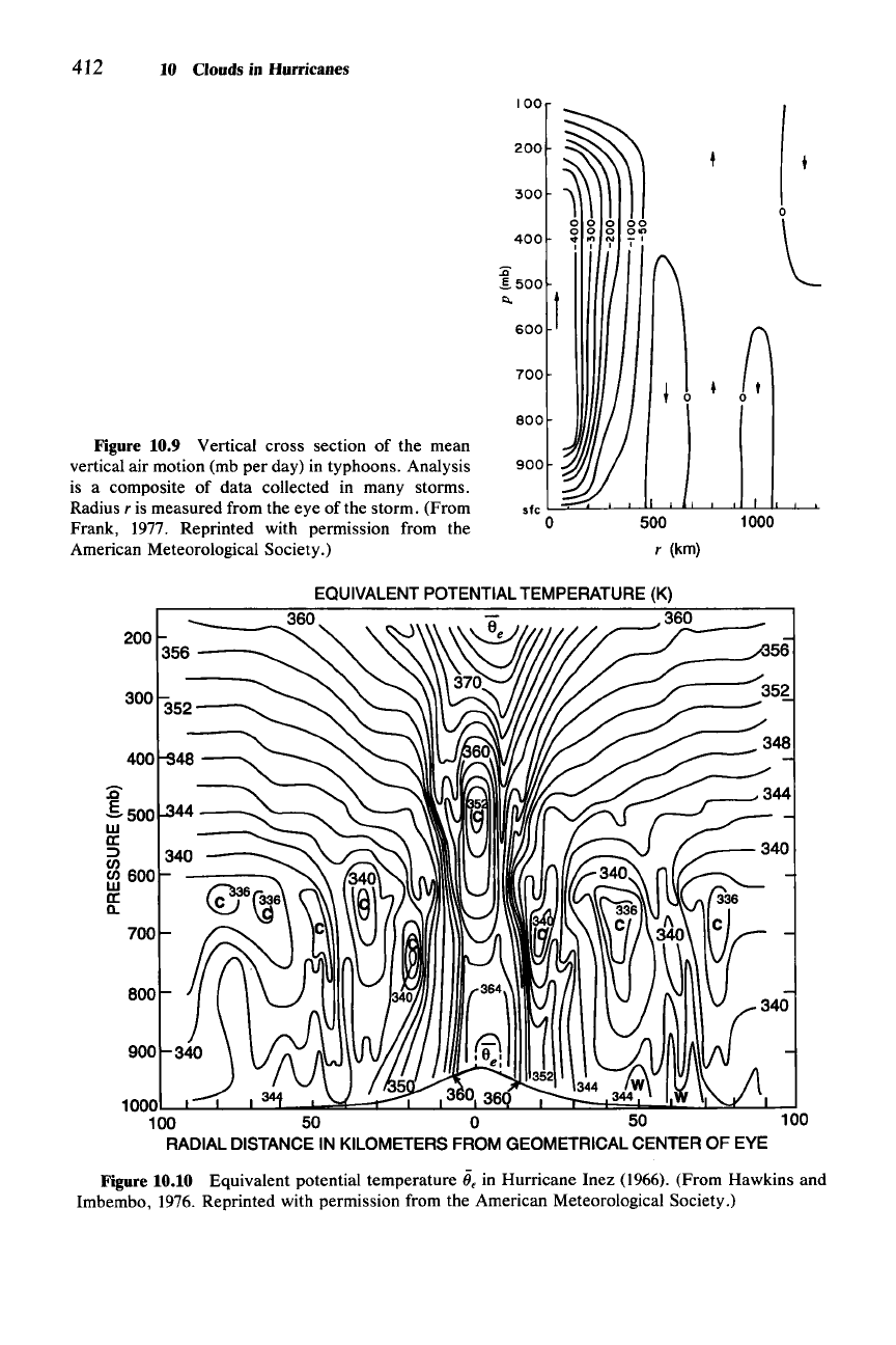
in a hurricane is shown in Fig. 10.9. The overall cloud and precipitation amounts
are determined by this vertical mass transport, which is concentrated within 400
km
ofthe
storm center. However, this mean vertical motion pattern does not have
the spatial resolution to provide much insight into cloud structures, nor does it
show the downward motion in the eye. To see these details, special aircraft and
radar instrumentation are required. Analyses of such data will be considered in
Sees. 10.2, 10.4, and 10.5.
The typical pattern
of
equivalent potential temperature in a hurricane,
lie,
is
indicated by the example in Fig. 10.10. The overbar signifies the mean-variable
field, which averages out turbulent and convective fluctuations. In the large-scale
environment, far from the
center
of the storm, the stratification of
lie
is typical of
the tropics. Potential instability (Sec. 2.9.1) predominates in the lower tropo-
sphere, with
lie
decreasing with height to a minimum at about the 650-mb level.
Above that level, the air is potentially stable. The pattern of
lie
changes markedly
as one proceeds inward toward the center of the storm. In the low levels, the
values of
ii
e
increase steadily to a maximum in the eye
ofthe
storm. In the vicinity
of the eyewall
(~IO
km from the storm center), the gradient of
lie
is the greatest,
and the isotherms of
lie
rise nearly vertically through the lower troposphere, then
flare outward as they extend into the upper troposphere. Since above the bound-
ary layer
lie
is conserved following a parcel [according to (2.18)], these contours
reflect the flow
of
air upward and outward in the eyewall. In the very center of the
storm, there is an especially strong decrease of
lie
with height. The center of low
lie
at 500 mb is evidence of the strong subsidence concentrated in the eye (not shown
in Fig. 10.9), while the very large maximum at low levels is the net result of the
boundary-layer turbulent mixing
over
the warm sea surface and inward advection
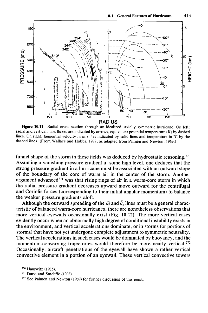
of the air being affected by the mixing. The vertical circulation in relation to
lie
is illustrated schematically in Fig. 10.11, where the low-level radial flow is de-
picted as converging into the center of the storm (consistent with Fig. 10.6)
in the boundary layer below cloud base. As it flows inward, turbulence pro-
duces the well-mixed boundary layer of high
lie.
When this air enters cloud in
the eyewall zone, it ascends undiluted to the upper troposphere along the lines of
constant
e..
An important quantity in any consideration of hurricane dynamics is the angu-
lar momentum
m about the central axis
of
the storm. This variable is defined by
(2.35), with
r in this case being the radial coordinate measured from the eye of the
storm. Since above the planetary boundary layer, where friction is unimportant,
m is conserved following a parcel [according to the inviscid equation (2.37)], the
isotherms of
lie
in Figs. 10.10 and 10.11 can also be regarded as lines of constant
m.
From
the discussion in Sec. 2.9.1, it is evident that the coincidence of mand
lie
within the saturated environment of a cloud is a characteristic feature of a circula-
tion which is in a state of conditional symmetric neutrality. This characteristic of
the hurricane will be useful in our subsequent theoretical discussion of the storm
dynamics.
The dynamical necessity of the outward-sloping structure of
m(and ii
e
)
lines in
the eyewall region was pointed out by early meteorological researchers. The
412 10 Clouds in Hurricanes
400
200
o
l
~
0 •
500
r
(km)
800
900
100
:<l
£500
"-
600
700
300
Figure 10.9 Vertical cross section of the mean
vertical air motion (mb per day) in typhoons. Analysis
is a composite of data collected in many storms.
Radius
r is measured from the eye of the storm. (From
Frank, 1977. Reprinted with permission from the
American Meteorological Society.)
EQUIVALENT
POTENTIAL
TEMPERATURE
(K)
___
..........
3.60
36,,0
_
356---'
200
1000 3 0 36
100 50 0 50 100
RADIAL
DISTANCE
IN KILOMETERS FROM GEOMETRICAL CENTEROF EYE
700
BOO
900
:Q'
.5.500
w
a:
=>
en
ffl
600
a:
a.
Figure 10.10 Equivalent potential temperature ii, in Hurricane Inez (1966). (From Hawkins and
Imbembo, 1976. Reprinted with permission from the American Meteorological Society.)
10.1 General Features of Hurricanes 413
l-
I
~
W
I
15
5
10
~
E
~
150
150
200
~
g
W
300
a:
\
:::J
C/)
400
C/)
W
a:
500
I
a..
700
I
850
,
~O
354·
~'
cr---k--~
-----
--60·
34~~
0'"
;----
-~~
34
-
<,
>0'
'-:,
\ I I
-------50·
~~
~~,~
\-
---
~
~,
•
34~\
"\\~~
'f~
"I
:-__
-
---
----4:A
'~4~
\
\\~~
~~
I t
---~___
10
~~\
\ \
\~\'
I
C~!M--=--
--~:::
\ \ \ \
\\\\"~
EYE
<,
~
,'\ \ \
\\\\\1'
I
!---\
~--------
-10
~l
:~\:/
\I\II!\: l.,
<,
~OO·
;;,
'I i\
~
11111\
\ :
\,~
b~LJ'\,t~i!ii!,J
'~~,i
---.,~
if:
~::
,,,.
-
..
".,,,::,,,
->'
50
40--
30---+
2
0•
100
50
0
50
100 150
RADIUS
Figure 10.11 Radial cross section through an idealized, axially symmetric hurricane. On left:
radial and vertical mass fluxes are indicated by arrows, equivalent potential temperature (K) by dashed
lines. On right: tangential velocity in m
S-I
is indicated by solid lines and temperature in °C by the
dashed lines. (From Wallace and Hobbs, 1977, as adapted from Palmeri and Newton, 1969.)
funnel shape of the storm in these fields was deduced by hydrostatic reasoning.F?
Assuming a vanishing pressure gradient at some high level, one deduces that the
strong pressure gradient in a hurricane must be associated with an outward slope
of the boundary of the core of warm air in the center of the storm. Another
argument advanced-" was that rising rings of air in a warm-core storm in which
the radial pressure gradient decreases upward move outward for the centrifugal
and Coriolis forces (corresponding to their initial angular momentum) to balance
the weaker pressure gradients aloft.
Although the outward spreading of the
iii
and ii. lines must be a general charac-
teristic of balanced warm-core hurricanes, there are nonetheless observations that
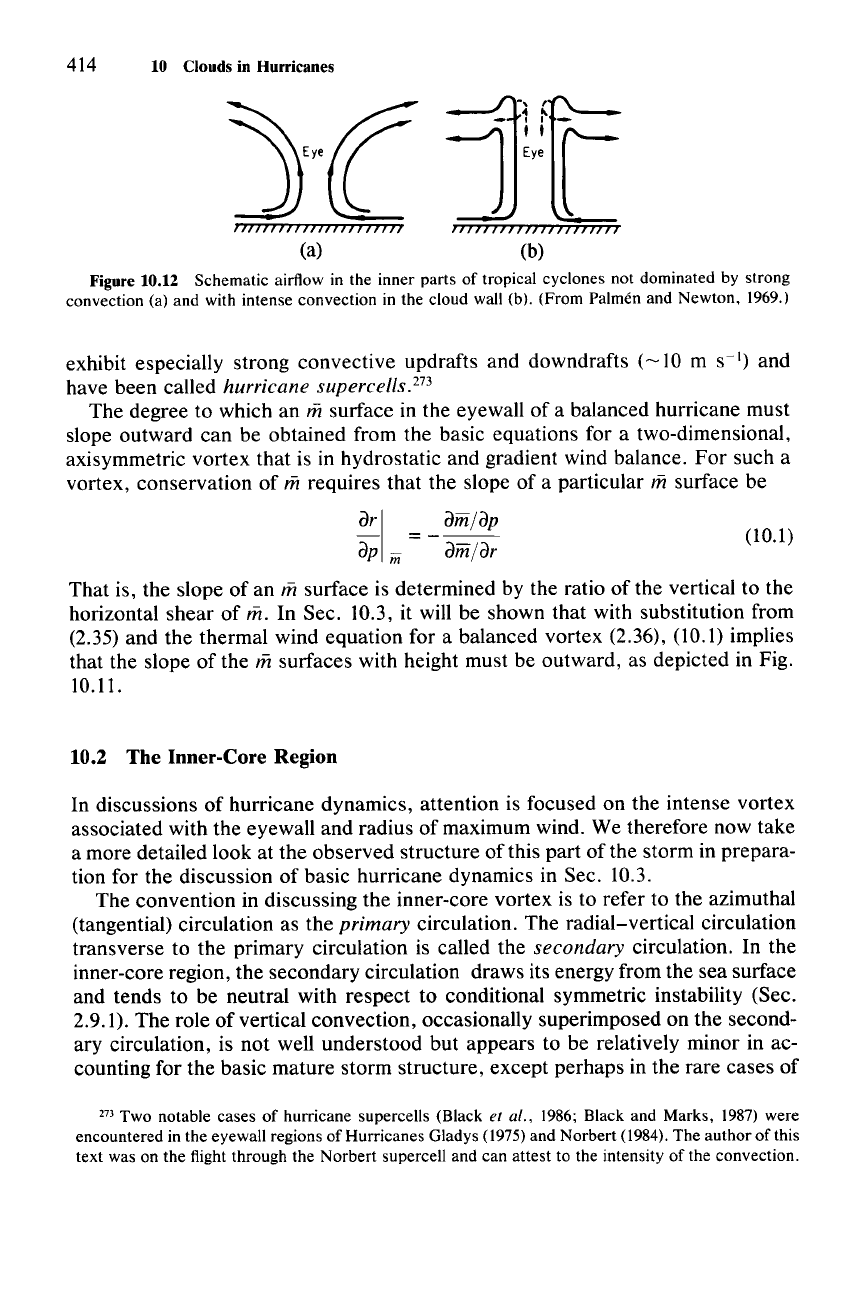
more vertical eyewalls occasionally exist (Fig. 10.12). The more vertical cases
evidently occur when an abnormally high degree of conditional instability exists in
the environment, and vertical accelerations dominate, or in storms (or portions of
storms) that have not yet undergone complete adjustment to symmetric neutrality.
The vertical accelerations in such cases would be dominated by buoyancy, and the
momentum-conserving trajectories would therefore be more nearly
vertical.F?
Occasionally, aircraft penetrations of the eyewall have shown a rather vertical
convective element in a portion of an eyewall. These vertical convective towers
270 Haurwitz (1935).
271 Durst and Sutcliffe (1938).
272 See Palmen and Newton (1969) for further discussion of this point.
414 10 Clouds in Hurricanes
(a)
(b)
Figure 10.12 Schematic airflow in the inner parts of tropical cyclones not dominated by strong
convection (a) and with intense convection in the cloud wall (b). (From Palmeri and Newton,
1969,)
exhibit especially strong convective updrafts and downdrafts
(~10
m s
")
and
have been called
hurricane supercells.273
The degree to which an msurface in the eyewall of a balanced hurricane must
slope outward can be obtained from the basic equations for a two-dimensional,
axisymmetric vortex that is in hydrostatic and gradient wind balance.
For
such a
vortex, conservation of
mrequires that the slope of a particular m surface be
dr I = _ _
dm_/_d_'P
dp
in dm/dr
(10.1)
That is, the slope of an m surface is determined by the ratio of the vertical to the
horizontal shear
of
m. In Sec. to.3, it will be shown that with substitution from
(2.35) and the thermal wind equation for a balanced vortex (2.36), (10.1) implies
that the slope of the
msurfaces with height must be outward, as depicted in Fig.
10.11.
10.2 The Inner-Core Region
In discussions of hurricane dynamics, attention is focused on the intense vortex
associated with the eyewall and radius
of
maximum wind. We therefore now take
a more detailed look at the observed structure of this part of the storm in prepara-
tion for the discussion of basic hurricane dynamics in Sec. 10.3.
The convention in discussing the inner-core vortex is to refer to the azimuthal
(tangential) circulation as the
primary circulation. The radial-vertical circulation
transverse to the primary circulation is called the
secondary circulation. In the
inner-core region, the secondary circulation draws its energy from the sea surface
and tends to be neutral with respect to conditional symmetric instability (Sec.
2.9.1). The role of vertical convection, occasionally superimposed on the second-
ary circulation, is not well understood but appears to be relatively minor in ac-
counting for the basic mature storm structure, except perhaps in the rare cases of
27) Two notable cases of hurricane supercells (Black et al. 1986; Black and Marks, 1987) were
encountered in the eyewall regions of Hurricanes Gladys (1975)and Norbert (1984), The author of this
text was on the flight through the Norbert supercell and can attest to the intensity of the convection,
10.2 The Inner- Core Region 415
vertical eyewalls (Fig. 10.12b). Vertical convection may also be more important in
early formative stages of the storm.
The clouds and precipitation associated with the hurricane inner core reflect
aspects of both the secondary circulation, whose vertical motions produce the
condensation, and the azimuthally spinning motions of the primary circulation,
which strongly redistributes particles by azimuthal advection around the storm.
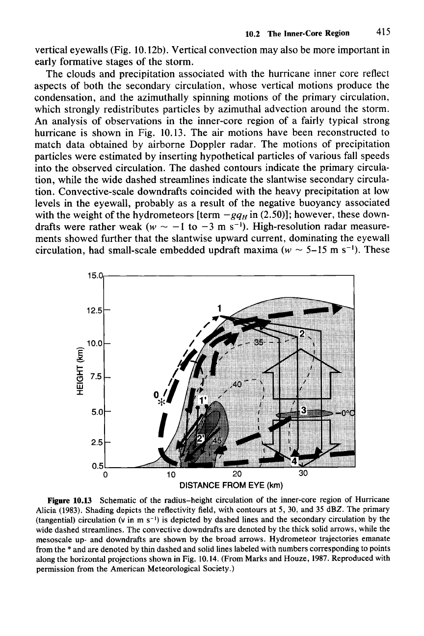
An analysis
of
observations in the inner-core region of a fairly typical strong
hurricane is shown in Fig. 10.13. The air motions have been reconstructed to
match data obtained by airborne Doppler radar. The motions of precipitation
particles were estimated by inserting hypothetical particles of various fall speeds
into the observed circulation. The dashed contours indicate the primary circula-
tion, while the wide dashed streamlines indicate the slantwise secondary circula-
tion. Convective-scale downdrafts coincided with the heavy precipitation at low
levels in the eyewall, probably as a result of the negative buoyancy associated
with the weight of the hydro meteors [term
-gqH
in (2.50)]; however, these down-
drafts were rather weak
(w -
-1
to
-3
m
S-I).
High-resolution radar measure-
ments showed further that the slantwise upward current, dominating the eyewall
circulation, had small-scale embedded updraft maxima
(w - 5-15 m
S-I).
These
15.0r-------------------------,
12.5
10.0
g
~
:I:
C) 7.5
jjj
:I:
5.0
2.5
0.5'"-
__
==
o
10 20
DISTANCE FROM EYE (km)
Figure 10.13 Schematic of the radius-height circulation of the inner-core region of Hurricane
Alicia
(1983). Shading depicts the reflectivity field, with contours at 5, 30, and 35 dBZ. The primary
(tangential) circulation (v in m
S-I)
is depicted by dashed lines and the secondary circulation by the
wide dashed streamlines. The convective downdrafts are denoted by the thick solid arrows, while the
mesoscale up- and downdrafts are shown by the broad arrows. Hydrometeor trajectories emanate
from the
* and are denoted by thin dashed and solid lines labeled with numbers corresponding to points
along the horizontal projections shown in Fig.
10.14. (From Marks and Houze, 1987. Reproduced with
permission from the American Meteorological Society.)
416 10 Clouds in Hurricanes
convective-scale cells
of
vertical motion indicate that some release of conditional
instability was occurring and that the slantwise circulation was not perfectly sym-
metrically neutral. At radii
>20
km or so the structure of the precipitation was
quite stratiform, with a well-defined bright band in the radar reflectivity at the
melting level. This stratiform structure adjacent to an intensely convective line (in
this case the eyewall) is rather similar to the precipitation patterns in the squall
lines and other mesoscale convective systems described in Chapter 9. From the
particle trajectories in Fig. 10.13, it is evident that the ice particles that are not
heavy enough to fall out in the eyewall convective rain shower are transported by
the strong radial wind at high levels sufficiently far outward to fall
out
in the
stratiform zone, as in the mesoscale convective systems described previously.
However, in the hurricane the horizontal paths of the particles wrap around the
storm as they are strongly advected azimuthally by the primary circulation, at the
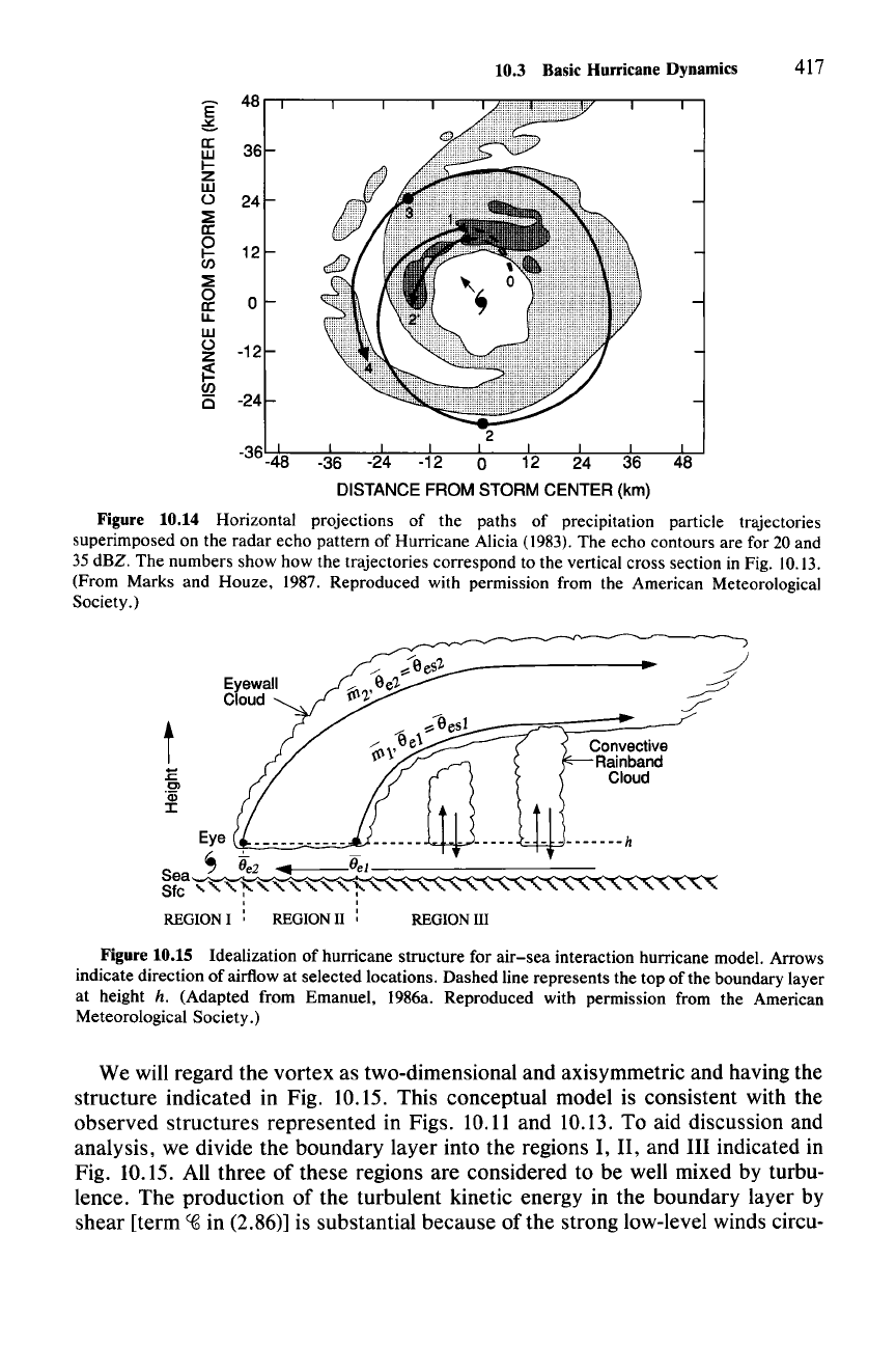
same time that they are carried outward by the secondary circulation (Fig. 10.14).
10.3 Basic Hurricane Dynamics
In this section, we examine some basic aspects of hurricane dynamics, with
emphasis on the clouds and precipitation that form in association with the second-
ary circulation in the inner-core region. In a mature hurricane, the secondary
circulation is the transverse circulation required to keep the primary circulation in
a state of gradient-wind and hydrostatic balance. One way to see the basic charac-
ter of the secondary circulation is to derive a cross-vortex stream function equa-
tion from the equations
of
the balanced vortex and solve for the transverse flow
associated with a heat source embedded in the eyewall.F" We will, however, take
an approach more directly related to the nature of the air motions of the clouds in
the inner-core region. This approach is based on the observation that the hurri-
cane circulation in the eyewall region tends to be potentially symmetrically neu-
tral
[aOes/az
= 0 on a surface of constant
iii,
where
()es
is the saturation equivalent
potential temperature defined by (2.146)], but not especially strongly potentially
unstable
(aOes/az
only slightly negative in the vertical direction). The conditional
symmetric neutrality is implied by the congruence
of
the
iii
and
Oes
surfaces in the
eyewall region (recall Fig. 10.11 and that
Oes
=
Oe
in cloud). In view
of
this
structure, we consider the dynamics of the eyewall cloud in terms of slantwise
neutral motions emanating from a boundary layer whose value of
Oe
has been
determined by upward flux of sensible and latent heat from the ocean surface.
This approach gives insight into both the primary and secondary circulation of a
mature hurricane by connecting the storm dynamics directly to the
air-sea
inter-
action that occurs in the boundary layer over the warm
ocean.i"
274 For a discussion of the cross-vortex stream function equation, see Schubert and Hack (1982). A
good example of the use of this approach is in the paper by Shapiro and Willoughby (1982).
275 From this point on, the discussion in this section, detailing the
air-sea
interaction dynamics of
the hurricane vortex, follows closely Emanuel (1986a).
:[
II:
W
I-
Z
W
o
~
II:
~
~
o
II:
u,
W
o
Z
~
en
C
10.3 Basic Hurricane Dynamics 417
48...--r----,-----,.---r---r-
36
24
12
o
-12
-24
2
-36-48 -36 -24 -12 0 12 24 36 48
DISTANCE FROM STORM CENTER (km)
Figure 10.14 Horizontal projections of the paths of precipitation particle trajectories
superimposed on the radar echo pattern of Hurricane Alicia (1983). The echo contours are for 20 and
35 dBZ. The numbers show how the trajectories correspond to the vertical cross section in Fig. 10.13.
(From Marks and Houze, 1987. Reproduced with permission from the American Meteorological
Society.)
t
:E
Cl
"ijj
:I:
REGION III
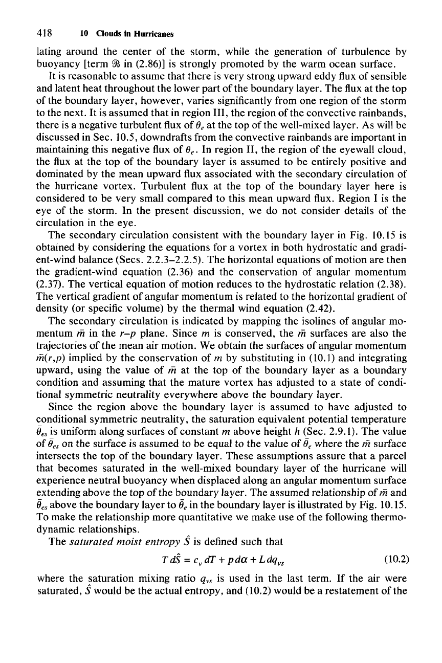
Figure 10.15 Idealization of hurricane structure for
air-sea
interaction hurricane model. Arrows
indicate direction of airflow at selected locations. Dashed line represents the top of the boundary layer
at height
h. (Adapted from Emanuel, 1986a. Reproduced with permission from the American
Meteorological Society.)
We will regard the vortex as two-dimensional and axisymmetric and having the
structure indicated in Fig. 10.15. This conceptual model is consistent with the
observed structures represented in Figs.
10.11
and 10.13. To aid discussion and
analysis, we divide the boundary layer into the regions I, II, and III indicated in
Fig. 10.15. All three of these regions are considered to be well mixed by turbu-
lence. The production of the turbulent kinetic energy in the boundary layer by
shear [term
C(6
in (2.86)] is substantial because of the strong low-level winds circu-
418 10 Clouds in Hurricanes
lating around the
center
of the storm, while the generation of turbulence by
buoyancy [term
~
in (2.86)] is strongly promoted by the warm ocean surface.
It
is reasonable to assume that there is very strong upward eddy flux of sensible
and latent heat throughout the lower part of the boundary layer. The flux at the top
of the boundary layer, however, varies significantly from one region of the storm
to the next.
It
is assumed
that
in region III, the region of the convective rainbands,
there is a negative turbulent flux of
(}e at the top of the well-mixed layer. As will be
discussed in Sec. 10.5, downdrafts from the convective rainbands are important in
maintaining this negative flux of
Be.
In region II, the region of the eyewall cloud,
the flux at the top of the boundary layer is assumed to be entirely positive and
dominated by the mean upward flux associated with the secondary circulation of
the hurricane vortex. Turbulent flux at the top of the boundary layer here is
considered to be very small compared to this mean upward flux. Region I is the
eye of the storm. In the present discussion, we do not consider details of the
circulation in the eye.
The secondary circulation consistent with the boundary layer in Fig. 10.15 is
obtained by considering the equations for a vortex in both hydrostatic and gradi-
ent-wind balance (Sees, 2.2.3-2.2.5). The horizontal equations
of
motion are then
the gradient-wind equation (2.36) and the conservation of angular momentum
(2.37). The vertical equation of motion reduces to the hydrostatic relation (2.38).
The vertical gradient
of
angular momentum is related to the horizontal gradient of
density (or specific volume) by the thermal wind equation (2.42).
The secondary circulation is indicated by mapping the isolines of angular mo-
mentum
m in the
r-p
plane. Since m is conserved, the msurfaces are also the
trajectories
of
the mean air motion. We obtain the surfaces
of
angular momentum
m(r,p)
implied by the conservation of m by substituting in (10.1) and integrating
upward, using the value of
m at the top of the boundary layer as a boundary
condition and assuming that the mature vortex has adjusted to a state of condi-
tional symmetric neutrality everywhere above the boundary layer.
Since the region above the boundary layer is assumed to have adjusted to
conditional symmetric neutrality, the saturation equivalent potential temperature
«,is uniform along surfaces of constant m above height h (Sec. 2.9.1). The value
of
Oe"
on the surface is assumed to be equal to the value of
Oe
where the msurface
intersects the top
of
the boundary layer. These assumptions assure that a parcel
that becomes saturated in the well-mixed boundary layer of the hurricane will
experience neutral buoyancy when displaced along an angular momentum surface
extending above the top of the boundary layer. The assumed relationship
of
mand
Oes
above the boundary layer to
Oe
in the boundary layer is illustrated by Fig. 10.15.
To make the relationship more quantitative we make use of the following thermo-
dynamic relationships.
The
saturated
moist
entropy Sis defined such that
T dS = c
y
dT + p
da
+ LdqyS (10.2)
where the saturation mixing ratio
qyS
is used in the last term. If the air were
saturated,
Swould be the actual entropy, and (10.2) would be a restatement of the
