Houze Robert A., Jr. Cloud Dynamics
Подождите немного. Документ загружается.

11 Precipitating Clouds in Extratropical Cyclones 439
surface and are characterized by predominantly convective clouds at some point
in their lifetimes. Comma clouds, such as the smaller cloud system to the west of
the main frontal cyclonic cloud system in Fig. 1.29, are the larger of the polar
lows, and they themselves may exhibit a surface low center and fronts, which are
the products of cyclogenesis and frontogenesis associated with a baroclinic wave
of especially short wavelength. Polar lows occurring farther from major frontal
cloud systems tend to be the smallest members of the spectrum and sometimes
appear to have a hurricane-like appearance (Fig. 1.30).
In this chapter, we focus on the clouds of extratropical cyclones (large frontal
cyclones, comma cloud systems, and smaller polar lows). We have already con-
sidered aspects
ofthese
clouds in Chapters
1,5,
and 6. In particular, we examined
the cloud streets, which form as the equatorward-moving cold-air stream of a
cyclone moves out over a warmer ocean surface (Figs. 1.11b, 1.30, and 5.21).
Although the individual clouds comprising the cloud streets may occasionally
precipitate, they are not the primary precipitation-producing clouds of the cy-
clones. Rather it is the broader bands of clouds with extensive cirriform cloud
tops, seen in satellite pictures such as those in Figs. 1.29 and 1.30 to be curling
around and extending outward from cyclonic storm centers, that produce most of
the precipitation in extratropical cyclones. In Chapter 6, we considered some
basic structural aspects of these larger, precipitating clouds. In this chapter, we
seek a dynamical and physical understanding of them.
Of all the cloud systems considered in this text, the precipitating clouds in
extratropical cyclones have the widest range of scales of phenomena contributing
to the cloud formation processes. The plan of this chapter is to proceed from the
largest of these scales to the smallest. On the largest scale, the dynamics of the
synoptic-scale baroclinic wave itself contribute to producing the clouds and pre-
cipitation, since it is the area of upward air motion within the wave that consti-
tutes the broad-scale region in which clouds can form. Therefore, we will begin in
Sec. 11.1 by considering the dynamics governing the vertical air motions of the
wave. We will see also, in that discussion, how the wind field in the baroclinic
wave favors the development of the low-level cyclone. In Sec. 11.2, we will
investigate how the vertical motions associated with the wave become concen-
trated in the vicinity offrontal zones by examining the dynamics offrontogenesis.
This discussion will serve to indicate the nature of the vertical circulation associ-
ated with the frontal zones that occur in a baroclinic wave.
It
is these vertical
circulations that are of primary importance in focusing the cloud formation pro-
cesses in the cyclone at the frontal zones. In Sec. 11.3, we will investigate how the
frontal zones, produced by frontogenesis, are distributed spatially within a devel-
oping cyclone, since this spatial pattern determines, to a first approximation, the
distribution of precipitating clouds in extratropical cyclones. Superimposed on the
clouds produced by the frontal air motions are still smaller mesoscale
rainbands
and convection, within which the precipitation-producing cloud microphysical
processes are most concentrated. In Sees. 11.4 and 11.5, we examine this super-
imposed structure by reviewing the observed structure of clouds and precipitation
in extratropical cyclones. Sections 11.4.1 and 11.4.2 concentrate on the more
440 11 Precipitating Clouds in Extratropical Cyclones
general aspects of the observed pattern of clouds and precipitation in a developing
frontal cyclone. Then Sees. 11.4.3-11.4.6 describe in more detail the clouds and
rainbands that occur within specific parts of this pattern. Finally, Sec. 11.5 exam-
ines the clouds of polar lows.
11.1 Structure and Dynamics of a Baroclinic Wave
11.1.1 Idealized Horizontal and Vertical Structure
A baroclinic wave can develop in the atmosphere when the wind at a given
pressure level is blowing parallel to the temperature (or potential temperature)
isotherms and there is a nonzero temperature gradient across the flow. If certain
other conditions are met, a small initial wave perturbation superimposed on the
flow will amplify, and the situation is referred to as a state of
baroclinic instabil-
ity.283
To obtain a qualitative understanding of the baroclinic wave-growth pro-
cess, consider a region of strong
north-south
temperature gradient in the North-
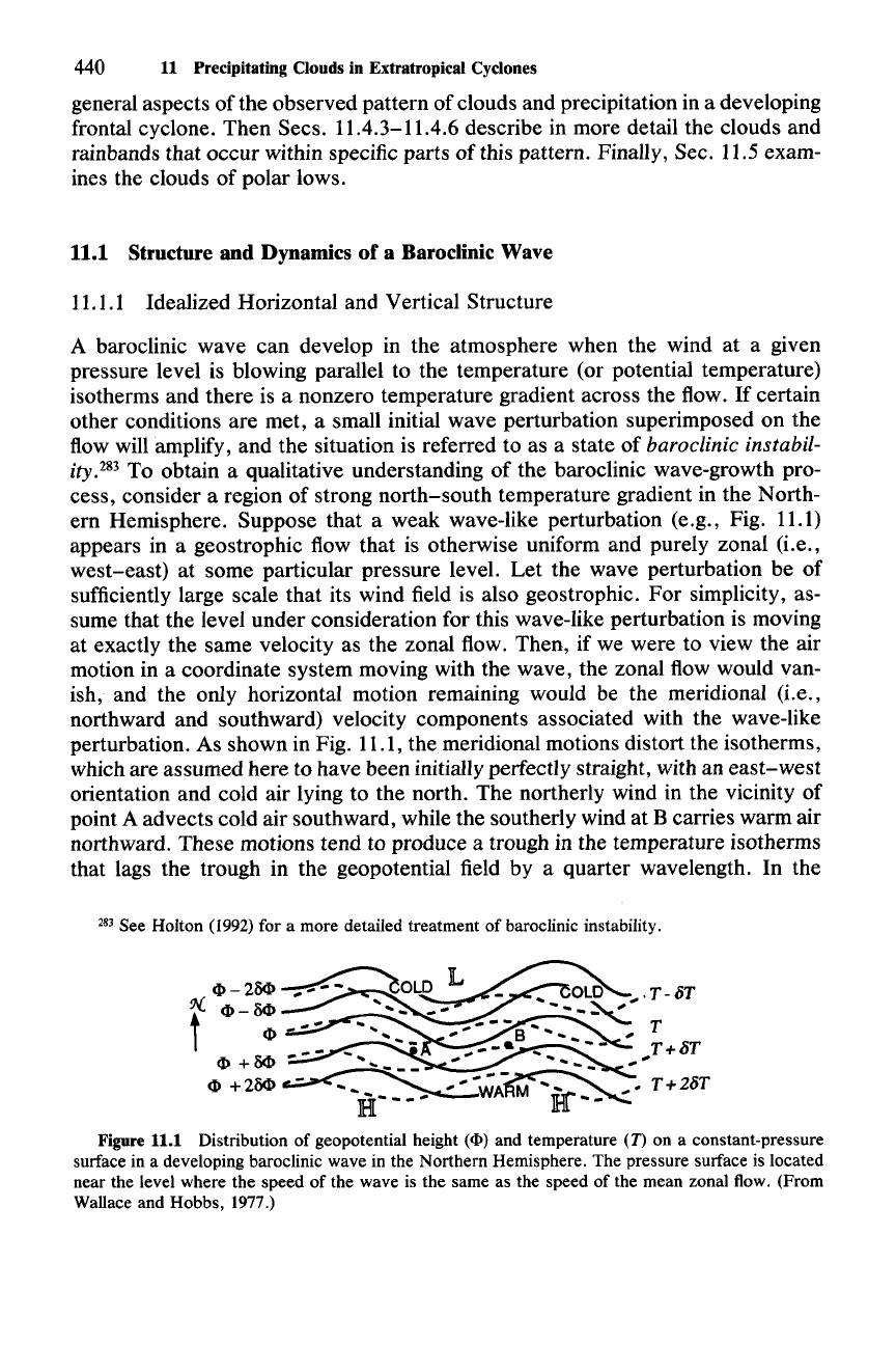
ern Hemisphere. Suppose that a weak wave-like perturbation (e.g., Fig. 11.1)
appears in a geostrophic flow that is otherwise uniform and purely zonal (i.e.,
west-east) at some particular pressure level.
Let
the wave perturbation be of
sufficiently large scale that its wind field is also geostrophic. For simplicity, as-
sume that the level under consideration for this wave-like perturbation is moving
at exactly the same velocity as the zonal flow. Then, if we were to view the air
motion in a coordinate system moving with the wave, the zonal flow would van-
ish, and the only horizontal motion remaining would be the meridional (i.e.,
northward and southward) velocity components associated with the wave-like
perturbation. As shown in Fig. 11.1, the meridional motions distort the isotherms,
which are assumed here to have been initially perfectly straight, with an
east-west
orientation and cold air lying to the north. The northerly wind in the vicinity of
point A advects cold air southward, while the southerly wind at B carries warm air
northward. These motions tend to produce a trough in the temperature isotherms
that lags the trough in the geopotential field by a quarter wavelength. In the
283 See Holton (1992) for a more detailed treatment of baroclinic instability.
Figure 11.1 Distribution of geopotential height
(<I»
and temperature
(D
on a constant-pressure
surface in a developing baroclinic wave in the Northern Hemisphere. The pressure surface is located
near the level where the speed of the wave is the same as the speed of the mean zonal flow. (From
Wallace and Hobbs,
1977.)
11.1 Structure and Dynamics of a Baroclinic Wave
441
absence of other influences, the horizontal temperature advection by the perturba-
tion flow will continue to distort the isotherms from their original east-west
configuration, thus causing the
east-west
temperature contrasts in the wave to
amplify further.
In a growing wave, in which the temperature perturbations are becoming
larger, the kinetic energy associated with the wave disturbance increases. The
mechanism by which the kinetic energy increases is a thermally direct circulation,
in which the warmer air at B rises and the cooler air at A sinks, thus lowering the
center of gravity of the fluid. The air at B is then on an upward-sloping poleward
trajectory, while the air at A is on a downward-sloping equatorward trajectory.
Implications for cloud formation are then clear: clouds are favored east of the
trough of the baroclinic wave, while they are suppressed on the west side of the
trough.
The range of slopes of parcel trajectories is limited.
For
example, the rise of air
that we have postulated to occur at B cannot be too great, or else the effect of
warm advection will be completely counteracted by the decrease of temperature,
which must occur as the air rises. The allowable flow configurations can be deter-
mined theoretically, and the ones for which the disturbance grows most rapidly
can be calculated.P' All of these details are not necessary for our present discus-
sion. We will confine ourselves to some general features of the developing wave
that will enhance our appreciation of the vertical motions, which determine the
regions of the wave where clouds may be favored or suppressed.
To gain a qualitative picture of the nature of the vertical motions, we may
consider some aspects of the vertical structure of the idealized baroclinic wave
that are implied by the out-of-phase relationship of the temperature and geopoten-
tial height contours. The location of the temperature trough to the west of the
trough in the geopotential field (Fig. 11.1) indicates that the trough of the baro-
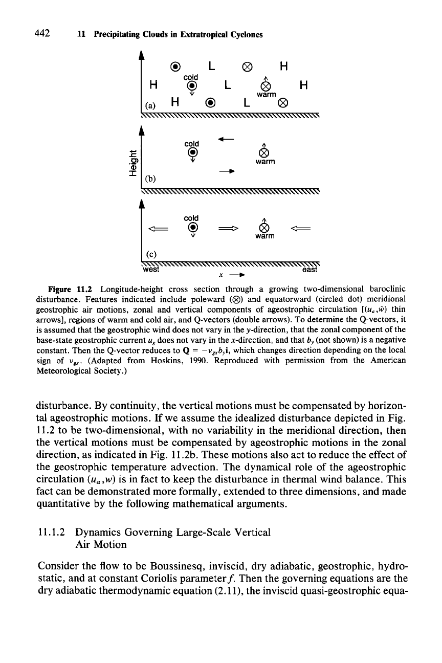
clinic wave tilts toward the west with height, as shown in Fig. 11.2. The tilt of the
trough toward the cold air is required in order to maintain hydrostatic balance
throughout the disturbance.P" The ridge in the height field (or high in the pressure
field) tilts westward for the same reason. Since the wave disturbance is in geo-
strophic balance, the winds between the ridges and troughs alternate between
northerly and southerly as indicated in Fig. 11.2. Since the disturbance is both
geostrophically and hydrostatically balanced, the thermal wind relation (Sec.
2.2.5) applies. Recall, however, that the northerly geostrophic winds advect
colder air into the plane of the cross section, and the southerly geostrophic winds
bring in warmer air. In the absence of other effects, these advective effects would
destroy the thermal wind balance. The upward motion of the warm air and the
downward motion of the cold air are needed to restore the balance. As the warm
air ascends, its temperature is lowered as a result of the expansion. The tempera-
ture of the cold air increases as it sinks. These temperature changes thus mitigate
the effect of the advection by lessening the
west-east
thermal contrast across the
284 See Hoskins (1990) or Holton (1992).
285 See Wallace and Hobbs (1977, Fig. 2.3c).
442
11
Precipitating Clouds in Extratropical Cyclones
@
L
0
H
H
cold
0
~
L
H
warm
(a)
H
@
L
0
cold
.--
.E
~
0
Ol
warm
'Qj
--+
:c
(b)
"
cold
0
<:==
~
~
<:==
warm
(c)
~wes
eas
x
--+
Figure 11.2 Longitude-height cross section through a growing two-dimensional baroclinic
disturbance. Features indicated include poleward
«(8)
and equatorward (circled dot) meridional
geostrophic air motions, zonal and vertical components of ageostrophic circulation
[(ua,lii) thin
arrows], regions of warm and cold air, and Q-vectors (double arrows). To determine the Q-vectors, it
is assumed that the geostrophic wind does not vary in the y-direction, that the zonal component of the
base-state geostrophic current
u
g
does not vary in the x-direction, and that by (not shown) is a negative
constant. Then the Q-vector reduces to
Q = -vgxbyi, which changes direction depending on the local
sign of
Vgxo (Adapted from Hoskins, 1990. Reproduced with permission from the American
Meteorological Society.)
disturbance. By continuity, the vertical motions must be compensated by horizon-
tal ageostrophic motions. If we assume the idealized disturbance depicted in Fig.
11.2 to be two-dimensional, with no variability in the meridional direction, then
the vertical motions must be compensated by ageostrophic motions in the zonal
direction, as indicated in Fig. 11.2b. These motions also act to reduce the effect of
the geostrophic temperature advection. The dynamical role of the ageostrophic
circulation
(u
a
,
w) is in fact to keep the disturbance in thermal wind balance. This
fact can be demonstrated more formally, extended to three dimensions, and made
quantitative by the following mathematical arguments.
11.1.2 Dynamics Governing Large-Scale Vertical
Air Motion
Consider the flow to be Boussinesq, inviscid, dry adiabatic, geostrophic, hydro-
static, and at constant Coriolis parameter
f. Then the governing equations are the
dry adiabatic thermodynamic equation (2.11), the inviscid quasi-geostrophic equa-
11.1 Structure and Dynamics of a Baroclinic Wave 443
tion of motion with constant
f (2.23), the hydrostatic equation (2.38), and the
Boussinesq continuity equation (2.55).
In this chapter we will view these relationships in a reference frame in which
vertical variations are expressed in terms of the
pseudoheight
0,286
defined as
0==
[1-(p/P)IC](I/K)H
s
(11.1)
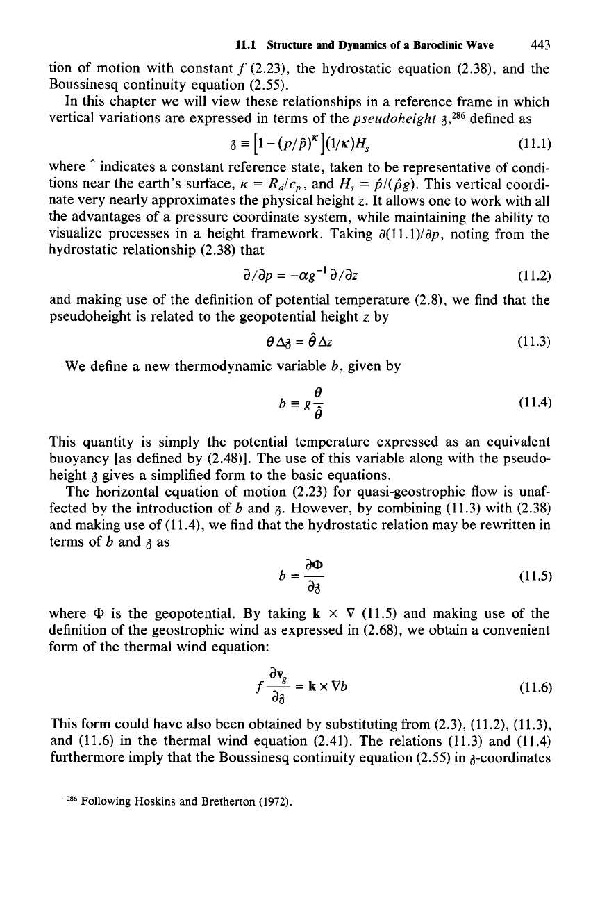
where A indicates a constant reference state, taken to be representative of condi-
tions near the
earth's
surface, K = Rd/c
p
,
and H, = p/(pg). This vertical coordi-
nate very nearly approximates the physical height z.
It
allows one to work with all
the advantages
of
a pressure coordinate system, while maintaining the ability to
visualize processes in a height framework. Taking
a(11.1)/
Bp; noting from the
hydrostatic relationship (2.38) that
d/dp =
_ag-
1
dldz
(11.2)
and making use of the definition of potential temperature (2.8), we find that the
pseudoheight is related to the geopotential height z by
9~0
= 0&
We define a new thermodynamic variable b, given by
9
b==g"
9
(11.3)
(11.4)
This quantity is simply the potential temperature expressed as an equivalent
buoyancy [as defined by (2.48)]. The use of this variable along with the pseudo-
height 0 gives a simplified form to the basic equations.
The horizontal equation of motion (2.23) for quasi-geostrophic flow is unaf-
fected by the introduction of
band
O.
However, by combining (11.3) with (2.38)
and making use of (11.4), we find that the hydrostatic relation may be rewritten in
terms
of
band
0 as
del>
b=-
do
(11.5)
(11.6)
where
eI>
is the geopotential. By taking k x V (11.5) and making use of the
definition of the geostrophic wind as expressed in (2.68), we obtain a convenient
form of the thermal wind equation:
dV
f-
g
=
kxVb
do
This form could have also been obtained by substituting from (2.3), (11.2), (11.3),
and (11.6) in the thermal wind equation (2.41). The relations (11.3) and (11.4)
furthermore imply that the Boussinesq continuity equation (2.55) in o-coordinates
286 Following Hoskins and Bretherton (1972).
(11.7)
444
11 Predpitating Clouds in Extratropical Cyclones
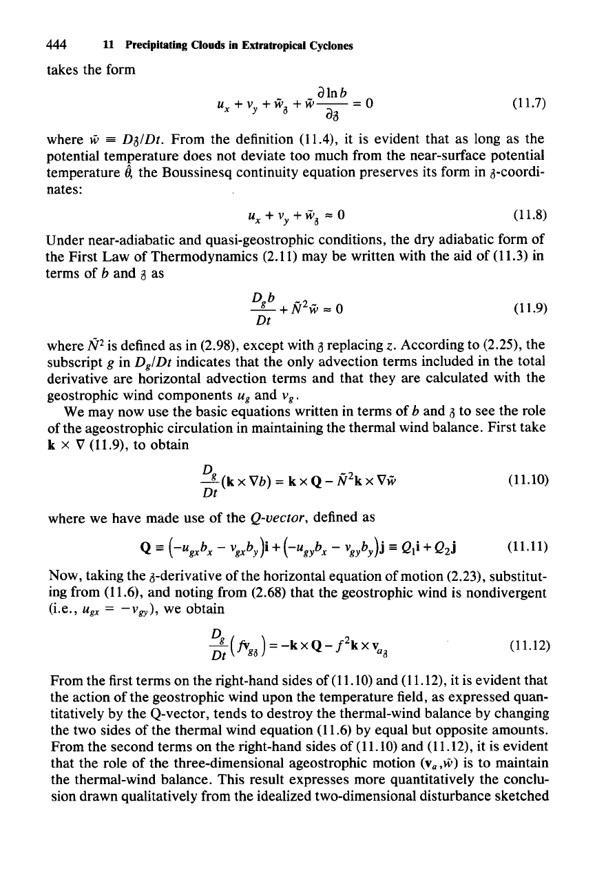
takes the form
alnb
UX+VY+W
a
+waa=O
where w =
DalDt.
From the definition (11.4), it is evident that as long as the
potential temperature does not deviate too much from the near-surface potential
temperature
0,
the Boussinesq continuity equation preserves its form in a-coordi-
nates:
-,
+ v
y
+ w
a
'" 0 (11.8)
Under near-adiabatic and quasi-geostrophic conditions, the dry adiabatic form of
the First Law of Thermodynamics (2.11) may be written with the aid of (11.3) in
terms of
b and a as
Dgb
-2
- + N W '" 0 (11.9)
Dt
where
N2
is defined as in (2.98), except with a replacing z. According to (2.25), the
subscript
g in
Dg/Dt
indicates that the only advection terms included in the total
derivative are horizontal advection terms and that they are calculated with the
geostrophic wind components
u
g
and v
g
•
We may now use the basic equations written in terms of b and a to see the role
of the ageostrophic circulation in maintaining the thermal wind balance. First take
k x V (11.9), to obtain
D
g
(k
x Vb) = k x Q - R2
k
x Vw
Dt
where we have made use of the Q-vector, defined as
Q
==
(-ugxb
x
-
vgxby)i
+
(-ugix
-
Vgiy)j
==
Q
1
i + Q
2
j
(11.10)
(11.11)
Now, taking the a-derivative of the horizontal equation of motion (2.23), substitut-
ing from (11.6), and noting from (2.68) that the geostrophic wind is nondivergent
(i.e.,
u
gx
=
-v
gy
) ,
we obtain
(11.12)
From the first terms on the right-hand sides of (11.10) and (11.12), it is evident that
the action of the geostrophic wind upon the temperature field, as expressed quan-
titatively by the Q-vector, tends to destroy the thermal-wind balance by changing
the two sides of the thermal wind equation (11.6) by equal but opposite amounts.
From the second terms on the right-hand sides of (11.10) and (11.12), it is evident
that the role of the three-dimensional ageostrophic motion
(va,w) is to maintain
the thermal-wind balance. This result expresses more quantitatively the conclu-
sion drawn qualitatively from the idealized two-dimensional disturbance sketched
11.1 Structure and Dynamics of a Baroclinic Wave 445
in Fig. 11.2b and extends the conclusion to three dimensions. The role of the
ageostrophic circulation in restoring the thermal wind balance at the same rate
that it is being destroyed by the action of the large-scale wind on the thermal field
can be seen most clearly by subtracting (11.12) from (11.10), which leads to
N
2V
Hw
-
f2
vao
= 2Q
(11.13)
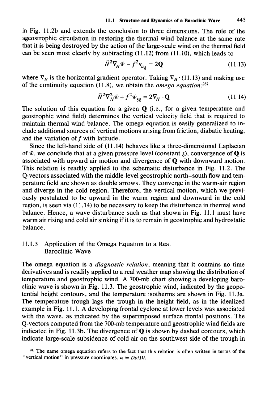
where VH is the horizontal gradient operator. Taking VH • (11.13) and making use
of the continuity equation (11.8), we obtain the
omega
equationV'
N2V~w+
f2
woo
= 2V
H
· Q (11.14)
The solution of this equation for a given Q (i.e., for a given temperature and
geostrophic wind field) determines the vertical velocity field that is required to
maintain thermal wind balance. The omega equation is easily generalized to in-
clude additional sources of vertical motions arising from friction, diabatic heating,
and the variation of
f with latitude.
Since the left-hand side of (11.14) behaves like a three-dimensional Laplacian
of
lV,
we conclude that at a given pressure level (constant 3), convergence of Q is
associated with upward air motion and divergence of
Q with downward motion.
This relation is readily applied to the schematic disturbance in Fig. 11.2. The
Q-vectors associated with the middle-level geostrophic north-south flow and tem-
perature field are shown as double arrows. They converge in the warm-air region
and diverge in the cold region. Therefore, the vertical motion, which we previ-
ously postulated to be upward in the warm region and downward in the cold
region, is seen via (11.14) to be necessary to keep the disturbance in thermal wind
balance. Hence, a wave disturbance such as that shown in Fig.
11.1
must have
warm air rising and cold air sinking if it is to remain in geostrophic and hydrostatic
balance.
11.1.3 Application of the Omega Equation to a Real
Baroclinic Wave
The omega equation is a
diagnostic relation, meaning that it contains no time
derivatives and is readily applied to a real weather map showing the distribution of
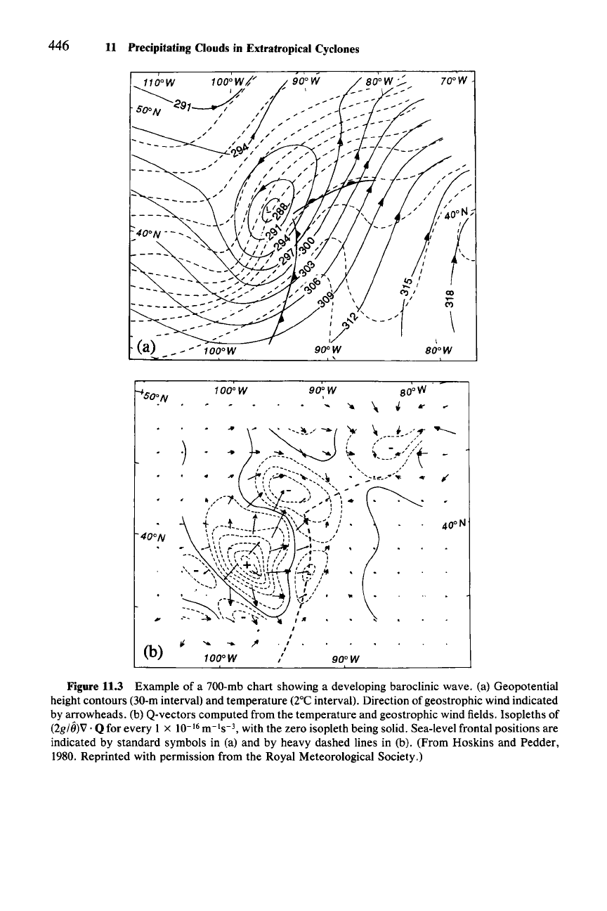
temperature and geostrophic wind. A 700-mb chart showing a developing baro-
clinic wave is shown in Fig. 11.3. The geostrophic wind, indicated by the geopo-
tential height contours, and the temperature isotherms are shown in Fig. 11.3a.
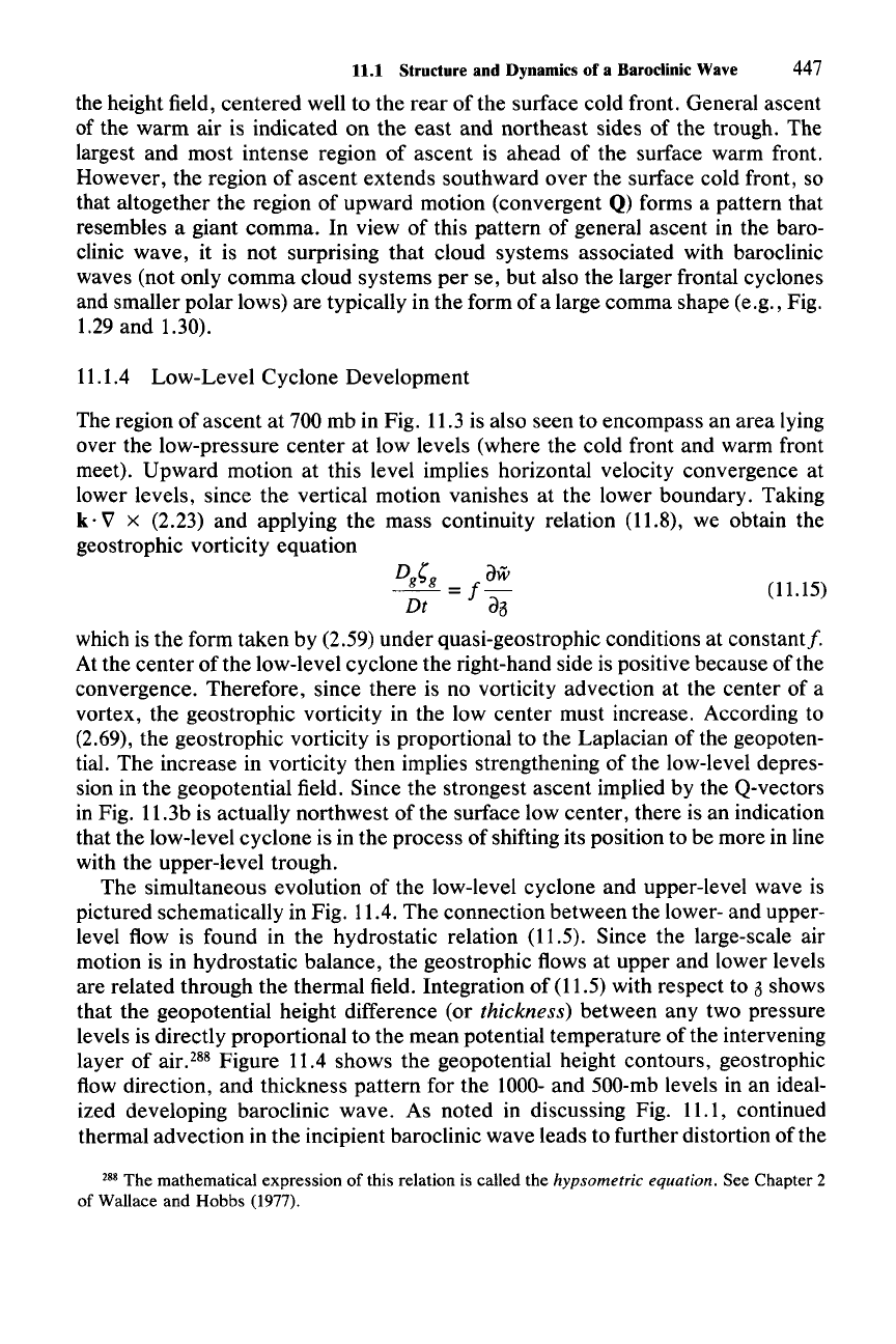
The temperature trough lags the trough in the height field, as in the idealized
example in Fig. 11.1. A developing frontal cyclone at lower levels was associated
with the wave, as indicated by the superimposed surface frontal positions. The
Q-vectors computed from the 700-mb temperature and geostrophic wind fields are
indicated in Fig. 11.3b. The divergence of
Q is shown by dashed contours, which
indicate large-scale subsidence of cold air on the southwest side of the trough in
287 The name omega equation refers to the fact that this relation is often written in terms of the
"vertical motion" in pressure coordinates. w
==
Dp/Dt.
446 11 Precipitating Clouds in Extratropieal Cyclones
-(a)
-
100
0W
50:N
100
0W
90
0W
'"
...
;..'
1
I
,
...
~
(b)
/
/
/
/
/~foo,N'
, ,
,
,
, \
I ' ... _
,
,
""
-'
co
-
C")
\
\
80
0W
80
0W
\
~
Ir
'"
J.
/-r
___
(-~~>:'t>
'---'"
;/
--:;.-u
__
.<
,
Figure 11.3 Example of a 700-mb chart showing a developing baroclinic wave. (a) Geopotential
height contours (30-m interval) and temperature (2°Cinterval). Direction of geostrophic wind indicated
by arrowheads. (b) Q-vectors computed from the temperature and geostrophic wind fields. Isopleths of
(2g/6)V .
Q for every 1 x 10-
16
m-1s-
J
,
with the zero isopleth being solid. Sea-levelfrontal positions are
indicated by standard symbols in (a) and by heavy dashed lines in (b). (From Hoskins and Pedder,
1980. Reprinted with permission from the Royal Meteorological Society.)
11.1 Structure and Dynamics of a Baroclinic Wave
447
the height field, centered well to the rear of the surface cold front. General ascent
of the warm air is indicated on the east and northeast sides of the trough. The
largest and most intense region of ascent is ahead of the surface warm front.
However, the region of ascent extends southward over the surface cold front, so
that altogether the region of upward motion (convergent
Q) forms a pattern that
resembles a giant comma. In view of this pattern of general ascent in the baro-
clinic wave, it is not surprising that cloud systems associated with baroclinic
waves (not only comma cloud systems per se, but also the larger frontal cyclones
and smaller polar lows) are typically in the form of a large comma shape (e.g., Fig.
1.29 and 1.30).
11.1.4 Low- Level Cyclone Development
The region of ascent at 700 mb in Fig. 11.3 is also seen to encompass an area lying
over the low-pressure center at low levels (where the cold front and warm front
meet). Upward motion at this level implies horizontal velocity convergence at
lower levels, since the vertical motion vanishes at the lower boundary. Taking
k·
V x (2.23) and applying the mass continuity relation (11.8), we obtain the
geostrophic vorticity equation
Dig
dW
--
=
f-
(11.15)
Dt
da
which is the form taken by (2.59) under quasi-geostrophic conditions at constant/.
At the center
ofthe
low-level cyclone the right-hand side is positive because of the
convergence. Therefore, since there is no vorticity advection at the center of a
vortex, the geostrophic vorticity in the low center must increase. According to
(2.69), the geostrophic vorticity is proportional to the Laplacian of the geopoten-
tial. The increase in vorticity then implies strengthening of the low-level depres-
sion in the geopotential field. Since the strongest ascent implied by the Q-vectors
in Fig. 11.3b is actually northwest of the surface low center, there is an indication
that the low-level cyclone is in the process of shifting its position to be more in line
with the upper-level trough.
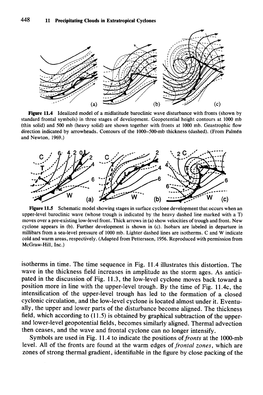
The simultaneous evolution of the low-level cyclone and upper-level wave is
pictured schematically in Fig. 11.4. The connection between the lower- and upper-
level flow is found in the hydrostatic relation (11.5). Since the large-scale air
motion is in hydrostatic balance, the geostrophic flows at upper and lower levels
are related through the thermal field. Integration of
(11.5) with respect to ashows
that the geopotential height difference (or
thickness) between any two pressure
levels is directly proportional to the mean potential temperature of the intervening
layer of air.
288 Figure 11.4 shows the geopotential height contours, geostrophic
flow direction, and thickness pattern for the
1000-
and
SOO-mb
levels in an ideal-
ized developing baroclinic wave. As noted in discussing Fig. 11.1, continued
thermal advection in the incipient baroclinic wave leads to further distortion of the
288 The mathematical expression of this relation is called the hypsometric equation. See Chapter 2
of Wallace and Hobbs (1977).
448 11 Precipitating Clouds in Extratropical Cyclones
Figure 11.4 Idealized model of a midlatitude baroclinic wave disturbance with fronts (shown by
standard frontal symbols) in three stages of development. Geopotential height contours at 1000 mb
(thin solid) and 500 mb (heavy solid) are shown together with fronts at 1000 mb. Geastrophic flow
direction indicated by arrowheads. Contours of the 1000-500-mb thickness (dashed). (From Palmen
and Newton, 1969.)
C
"
6.'
4,2
,I'
,
'.........
..'
"
T,
..
,,,
....
' ,
....
,
.....
--
-
•••
#,
"
~-~.-i::%~
6
·..
:·~w
(a)
Figure 11.5 Schematic model showing stages in surface cyclone development that occurs when an
upper-level baroclinic wave (whose trough is indicated by the heavy dashed line marked with a T)
moves over a pre-existing low-level front. Thick arrows in (a) show velocities of trough and front. New
cyclone appears in (b). Further development is shown in (c). Isobars are labeled in departure in
millibars from a sea-level pressure of 1000 mb. Lighter dashed lines are isotherms. C and W indicate
cold and warm areas, respectively. (Adapted from Petterssen, 1956.Reproduced with permission from
McGraw-Hill, Inc.)
isotherms in time.
The
time sequence in Fig. 11.4 illustrates this distortion.
The
wave in the thickness field increases in amplitude as the storm ages. As antici-
pated in the discussion of Fig. 11.3, the low-level cyclone moves back toward a
position more in line with the upper-level trough. By the time of Fig.
II.4c,
the
intensification of the upper-level trough has led to the formation of a closed
cyclonic circulation,
and
the low-level cyclone is located almost under it. Eventu-
ally, the
upper
and lower parts of the disturbance become aligned. The thickness
field, which according to (11.5) is obtained by graphical subtraction of the upper-
and lower-level geopotential fields, becomes similarly aligned. Thermal advection
then ceases,
and
the
wave and frontal cyclone
can
no longer intensify.
Symbols are used in Fig. 11.4 to indicate the positions
oi
fronts at the
lOOO-mb
level. All of the fronts are found at the warm edges of frontal zones, which are
zones of strong thermal gradient, identifiable in the figure by close packing of the
