Houze Robert A., Jr. Cloud Dynamics
Подождите немного. Документ загружается.

11.4 Clouds and Precipitation in a Frontal Cyclone 469
satellite data became available in the
1960s,300
it quickly became evident that cloud
patterns associated with developing cyclones exhibit a multiplicity of structures.
Attempts have been made to catalog the variety of cloud images seen in satellite
pictures under different combinations of upper-level waves and lower-level cy-
clones and fronts.'?' All of these variations are too numerous to examine in the
present text. We will look only at the most obvious and general aspects of the
satellite-observed cloud structure.
The basic upper-level cloud pattern associated with a baroclinic wave is in the
shape of a comma, which reflects the comma-shaped pattern of the zone of up-
ward motion on the eastern side of the trough of the wave (Fig. 11.3b). A good
example is the polar-low comma cloud seen trailing the large frontal cloud system
in Fig. 1.29.
It
is associated with a short-wavelength upper-level trough overtaking
the frontal system. The frontal cloud system is associated with another, longer-
wavelength baroclinic wave, and it too exhibits a comma configuration when
viewed from a satellite perspective. The comma in this case is larger, and its head
is formed by the broad cloud pattern centered near the northern head of the large
frontal cloud band, at the location of the surface low-pressure center. The cold-
frontal band forms the tail of the larger comma. This frontal-cloud comma is
produced as a combined effect of the general comma-shaped region of upward
motion associated with the baroclinic wave, the concentration of this upward
motion into narrow frontogenetical zones, and the advection of the cloud material
by the cyclonically circulating winds of the frontal low developing at low levels in
the context of the baroclinic wave (as illustrated in Fig. 11.4). Although details
vary from case to case, the general comma pattern is seen in nearly all cloud-
producing baroclinic waves.
A significant limitation of the cloud patterns viewed in conventional infrared
and visible satellite imagery is that one sees only the tops of the clouds. This view
is often dominated by a large sheet of cirriform cloud, as in the idealized example
300 The first weather satellite, TIROS I, was launched I April 1960.
301 See The Use
of
Satellite Pictures in Weather Analysis and Forecasting (Anderson et al., 1973),
Application
of
Satellite Data in Weather Analysis and Forecasting (Anderson et al., 1974), and
Satellite Imagery Interpretation for Forecasters, Vols. 1-3 (National Weather Association, 1986a-c).
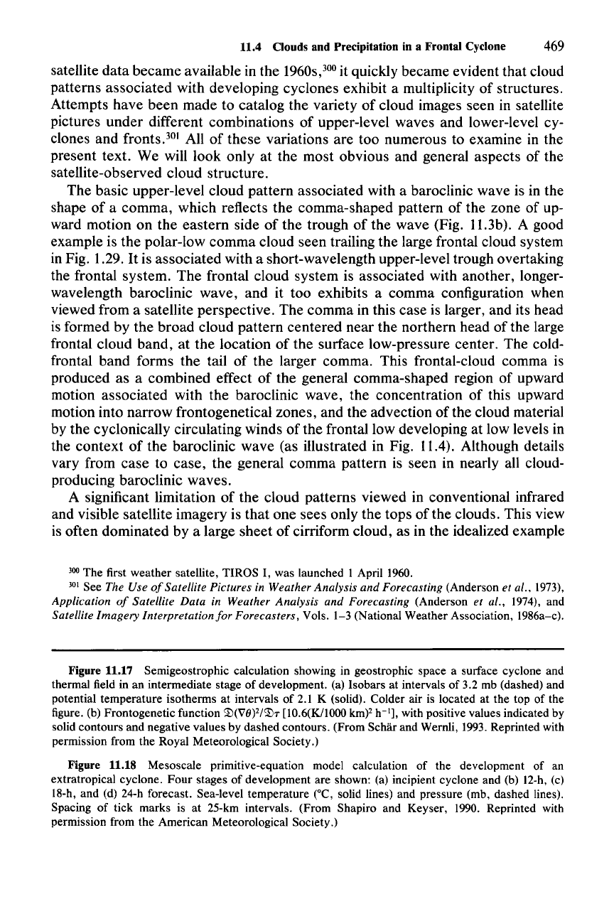
Figure 11.17 Semigeostrophic calculation showing in geostrophic space a surface cyclone and
thermal field in an intermediate stage of development. (a) Isobars at intervals of 3.2 mb (dashed) and
potential temperature isotherms at intervals of 2.1 K (solid). Colder air is located at the top of the
figure. (b) Frontogenetic function
~(VIi)2/~T
[10.6(K/IOOO
km)?
h-'j,
with positive values indicated by
solid contours and negative values by dashed contours. (From Schar and Wernli, 1993. Reprinted with
permission from the Royal Meteorological Society.)
Figure 11.18 Mesoscale primitive-equation model calculation of the development of an
extratropical cyclone.
Four
stages of development are shown: (a) incipient cyclone and (b) 12-h, (c)
18-h, and (d) 24-h forecast. Sea-level temperature CC, solid lines) and pressure (rnb, dashed lines).
Spacing of tick marks is at 25-km intervals. (From Shapiro and Keyser, 1990. Reprinted with
permission from the American Meteorological Society.)
470 11 Precipitating Clouds in Extratropical Cyclones
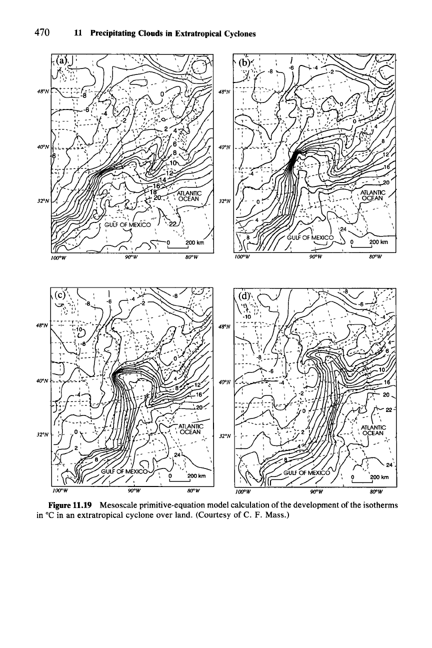
Figure 11.19
Mesoscale primitive-equation model calculation of the development
ofthe
isotherms
in °C in an extratropical cyclone over land. (Courtesy of C. F. Mass.)
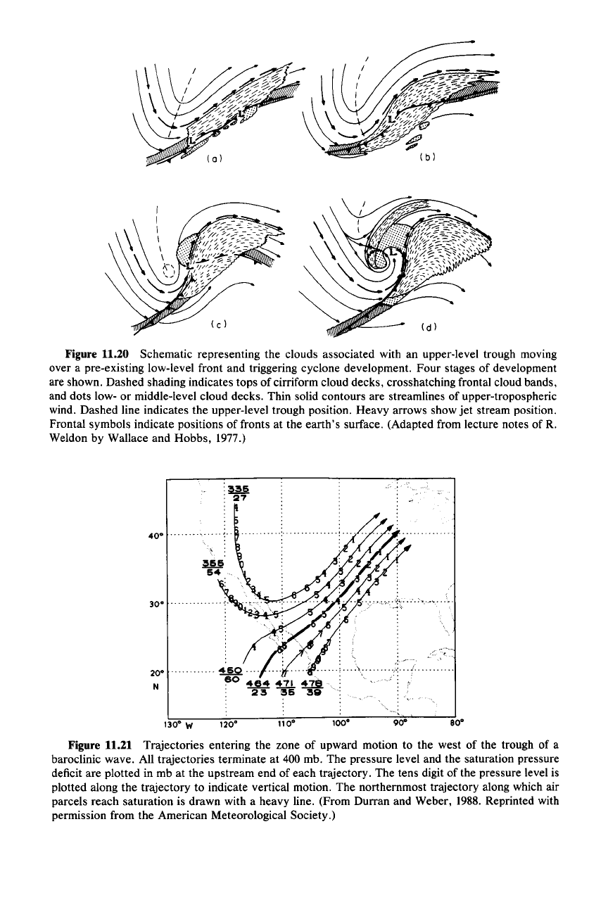
Figure 11.20 Schematic representing the clouds associated with an upper-level trough moving
over a pre-existing low-level front and triggering cyclone development. Four stages of development
are shown. Dashed shading indicates tops of cirriform cloud decks, crosshatching frontal cloud bands,
and dots low- or middle-level cloud decks. Thin solid contours are streamlines of upper-tropospheric
wind. Dashed line indicates the upper-level trough position. Heavy arrows show jet stream position.
Frontal symbols indicate positions of fronts at the earth's surface. (Adapted from lecture notes
ofR.
Weldon by Wallace and Hobbs, 1977.)
:~
.
27
40·
.
30·
...
20·
N
130·
W
120·
11o·
100·
80·
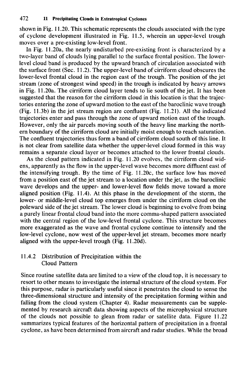
Figure 11.21 Trajectories entering the zone of upward motion to the west of the trough of a
baroclinic wave. All trajectories terminate at 400 mb. The pressure level and the saturation pressure
deficit are plotted in mb at the upstream end of each trajectory. The tens digit of the pressure level is
plotted along the trajectory to indicate vertical motion. The northernmost trajectory along which air
parcels reach saturation is drawn with a heavy line. (From Durran and Weber, 1988. Reprinted with
permission from the American Meteorological Society.)
472 11 Precipitating Clouds in Extratropical Cyclones
shown in Fig. 11.20. This schematic represents the clouds associated with the type
of cyclone development illustrated in Fig. 11.5, wherein an upper-level trough
moves over a pre-existing low-level front.
In Fig. 11.20a, the nearly undisturbed pre-existing front is characterized by a
two-layer band of clouds lying parallel to the surface frontal position. The lower-
level cloud band is produced by the upward branch of circulation associated with
the surface front (Sec. 11.2). The upper-level band of cirriform cloud obscures the
lower-level frontal cloud in the region east of the trough. The position of the
jet
stream (zone of strongest wind speed) in the trough is indicated by heavy arrows
in Fig. 11.20a. The cirriform cloud layer tends to lie south of the jet.
It
has been
suggested that the reason for the cirriform cloud in this location is that the trajec-
tories entering the zone of upward motion to the east of the baroclinic wave trough
(Fig. 11.3b) in the
jet
stream region are confluent (Fig. 11.21). All the indicated
trajectories enter and pass through the zone of upward motion east of the trough.
However, only the air parcels moving south of the heavy line marking the north-
ern boundary of the cirriform cloud are initially moist enough to reach saturation.
The confluent trajectories thus form a band of cirriform cloud south of this line.
It
is not clear from satellite data whether the upper-level cloud formed in this way
remains a separate cloud layer or becomes attached to the lower frontal clouds.
As the cloud pattern indicated in Fig. 11.20 evolves, the cirriform cloud wid-
ens, apparently as the flow in the upper-level wave becomes more diffluent east of
the intensifying trough. By the time of Fig. 11.20c, the surface low has moved
from a position east of the
jet
stream to a location under the
jet,
as the baroclinic
wave develops and the upper- and lower-level flow fields move toward a more
aligned position (Fig. 11.4). At this phase in the development of the storm, the
lower- or middle-level cloud top emerges from under the cirriform cloud on the
poleward side of the
jet
stream. The lower cloud is beginning to evolve from being
a purely linear frontal cloud band into the more comma-shaped pattern associated
with the central region of the low-level frontal cyclone. This structure becomes
more exaggerated as the wave and frontal cyclone continue to intensify and the
low-level cyclone, now west of the upper-level
jet
stream, becomes more nearly
aligned with the upper-level trough (Fig. 11.20d).
11.4.2 Distribution of Precipitation within the
Cloud Pattern
Since routine satellite data are limited to a view
ofthe
cloud top, it is necessary to
resort to other means to investigate the internal structure of the cloud system. For
this purpose, radar is particularly useful since it penetrates the cloud to sense the
three-dimensional structure and intensity of the precipitation forming within and
falling from the cloud system (Chapter 4). Radar measurements can be supple-
mented by research aircraft data showing aspects of the microphysical structure
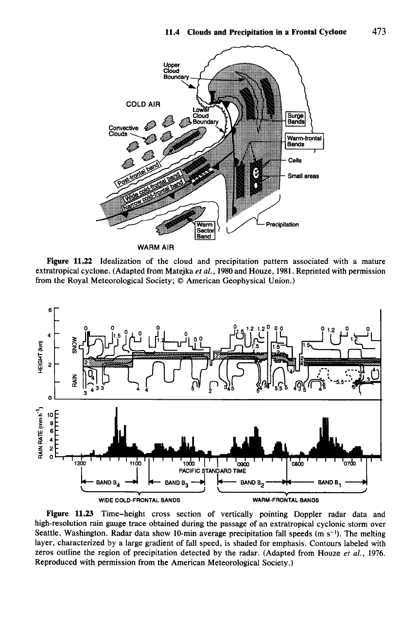
of the clouds not possible to glean from radar or satellite data. Figure 11.22
summarizes typical features of the horizontal pattern of precipitation in a frontal
cyclone, as have been determined from aircraft and radar studies. While the broad
11.4 Clouds and Precipitation in a Frontal Cyclone 473
WARM AIR
Figure 11.22 Idealization of the cloud and precipitation pattern associated with a mature
extratropical cyclone. (Adapted from Matejka et al., 1980and Houze, 1981.Reprinted with permission
from the Royal Meteorological Society;
© American Geophysical Union.)
•
WARM·FRONTAL
BANDS
WIDE COLD·FRONTAL BANDS
1 1
0900
PACIFIC
STANDARD
TIME
BANDB
3
-.../
I.---
BANDB
2
---t~--
BANDB
1
........
-----v------..-J)
\I...
.,....------
......
J
6
4
3=
'E'
0
~
Z
I-
en
:I:
1:1
2
w
:I:
Z
~
0
';".c: 10
E
8
S.
~
6
4
z
2
~
0
Figure 11.23 Time-height cross section of vertically pointing Doppler radar data and
high-resolution rain gauge trace obtained during the passage of an extratropical cyclonic storm over
Seattle, Washington. Radar data show 10-min average precipitation fall speeds (m
S-I).
The melting
layer, characterized by a large gradient of fall speed, is shaded for emphasis. Contours labeled with
zeros outline the region of precipitation detected by the radar. (Adapted from Houze et al.,
1976.
Reproduced with permission from the American Meteorological Society.)
474 11 Precipitating Clouds in Extratropical Cyclones
outline of the frontal cloud in Fig. 11.22 follows the general outline of the large-
scale vertical motion field (indicated by the Q-vector convergence in Fig. 11.3b),
the overall pattern of precipitation (indicated by the light stippling in Fig. 11.22) is
somewhat more focused and mostly confined to the regions of vertical motion
associated with the surface cyclone and the major zones of active low-level fron-
togenesis (Sees. 11.2 and 11.3), namely the cold-frontal and warm-frontal zones.
As we have seen in previous discussions, these frontal zones merge and extend
into the region of the low center along the occluded front (Figs. 11.4, 11.16, 11.18,
11.19), and the precipitation pattern in Fig. 11.22 reflects this structure where the
cold- and warm-frontal precipitation regions join and extend in toward the low
center. Embedded within this general frontal precipitation pattern are various
smaller-scale features, the elongated ones being the rainbands. Within the rain-
bands are still smaller mesoscale regions of enhanced precipitation and convective
cells.
The categories of rainbands indicated in Fig. 11.22 include
warm-frontal, nar-
row cold-frontal, wide cold-frontal,
and surge rainbands, which occur within the
envelope of the general frontal precipitation pattern, and
warm-sector and post-
frontal
rainbands, which fall outside this region. The background precipitation
within the main envelope is primarily stratiform (i.e., consists of the type of
precipitation described in Chapter 6). The warm-frontal, wide cold-frontal, and
surge rainbands (discussed in Sees. 11.4.3-11.4.6) are enhancements of the basic
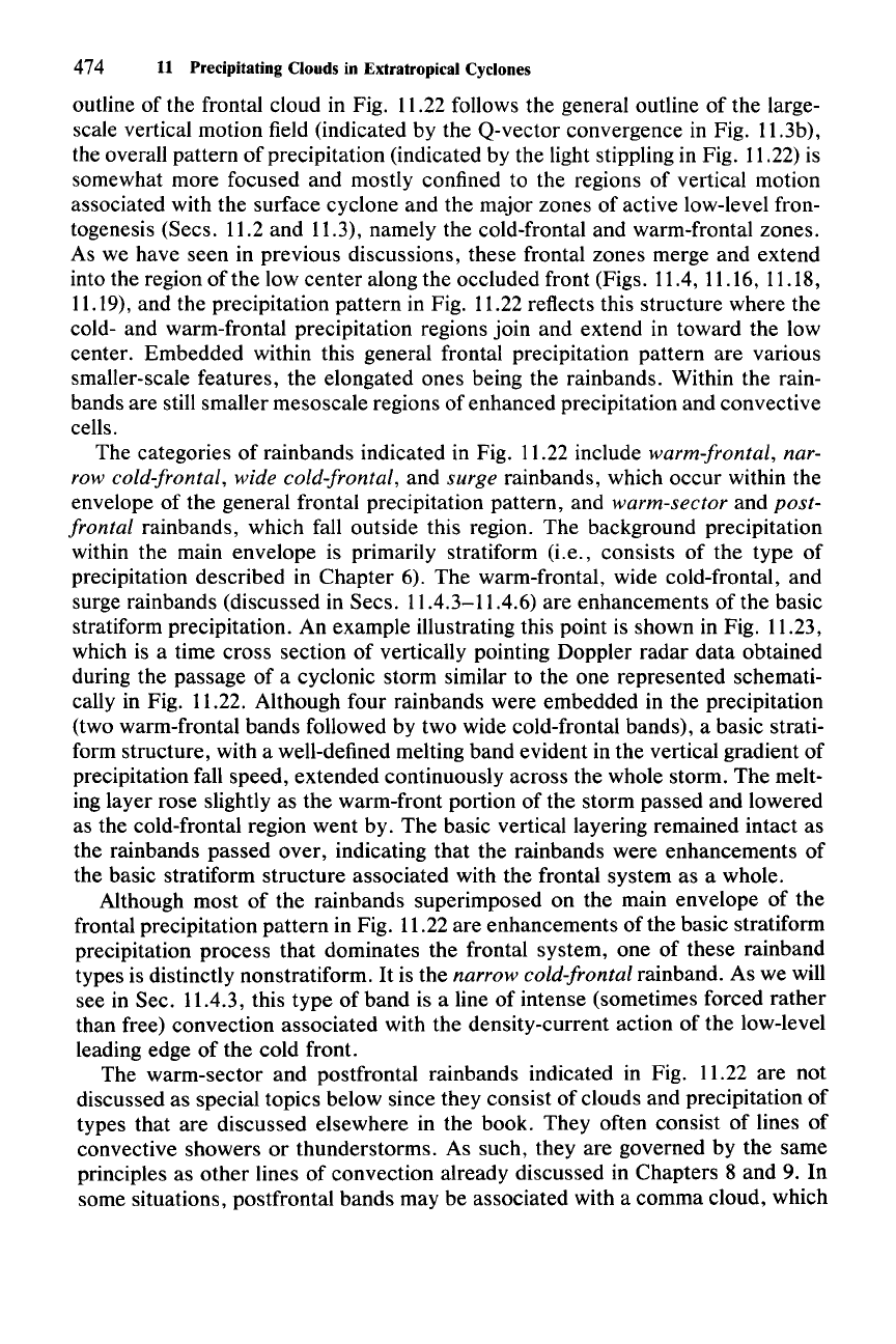
stratiform precipitation. An example illustrating this point is shown in Fig. 11.23,
which is a time cross section of vertically pointing Doppler radar data obtained
during the passage of a cyclonic storm similar to the one represented schemati-
cally in Fig. 11.22. Although four rainbands were embedded in the precipitation
(two warm-frontal bands followed by two wide cold-frontal bands), a basic strati-
form structure, with a well-defined melting band evident in the vertical gradient of
precipitation fall speed, extended continuously across the whole storm. The melt-
ing layer rose slightly as the warm-front portion of the storm passed and lowered
as the cold-frontal region went by. The basic vertical layering remained intact as
the rainbands passed over, indicating that the rainbands were enhancements of
the basic stratiform structure associated with the frontal system as a whole.
Although most of the rainbands superimposed on the main envelope of the
frontal precipitation pattern in Fig. 11.22 are enhancements of the basic stratiform
precipitation process that dominates the frontal system, one of these rainband
types is distinctly nonstratiform.
It
is the narrow cold-frontal rainband. As we will
see in Sec. 11.4.3, this type of band is a line of intense (sometimes forced rather
than free) convection associated with the density-current action of the low-level
leading edge of the cold front.
The warm-sector and postfrontal rainbands indicated in Fig. 11.22 are not
discussed as special topics below since they consist of clouds and precipitation of
types that are discussed elsewhere in the book. They often consist of lines of
convective showers or thunderstorms. As such, they are governed by the same
principles as other lines of convection already discussed in Chapters 8 and 9. In
some situations, postfrontal bands may be associated with a comma cloud, which
11.4 Clouds and Precipitation in a Frontal Cyclone 475
forms in the cold-air mass in connection with an approaching short-wave trough;
the comma-cloud phenomenon was introduced in Sec. 1.4.3 and will be discussed
further in Sec. 11.5.
We now turn (in Sees. 11.4.3-11.4.6) to a more detailed examination of the
rainbands and
other
features embedded in the general cloud and precipitation
pattern illustrated in Fig. 11.22. This discussion draws heavily from the results of
field studies in which the radar-echo patterns, air motions, thermodynamics, air-
craft-sampled cloud microphysics, and satellite imagery of frontal cloud systems
have been obtained simultaneously. Also contributing to this discussion are the
results
of
modeling studies, which have helped diagnose aspects of the observed
phenomena that are beyond
our
present capability to observe directly.
11.4.3 Narrow Cold-Frontal Rainbands
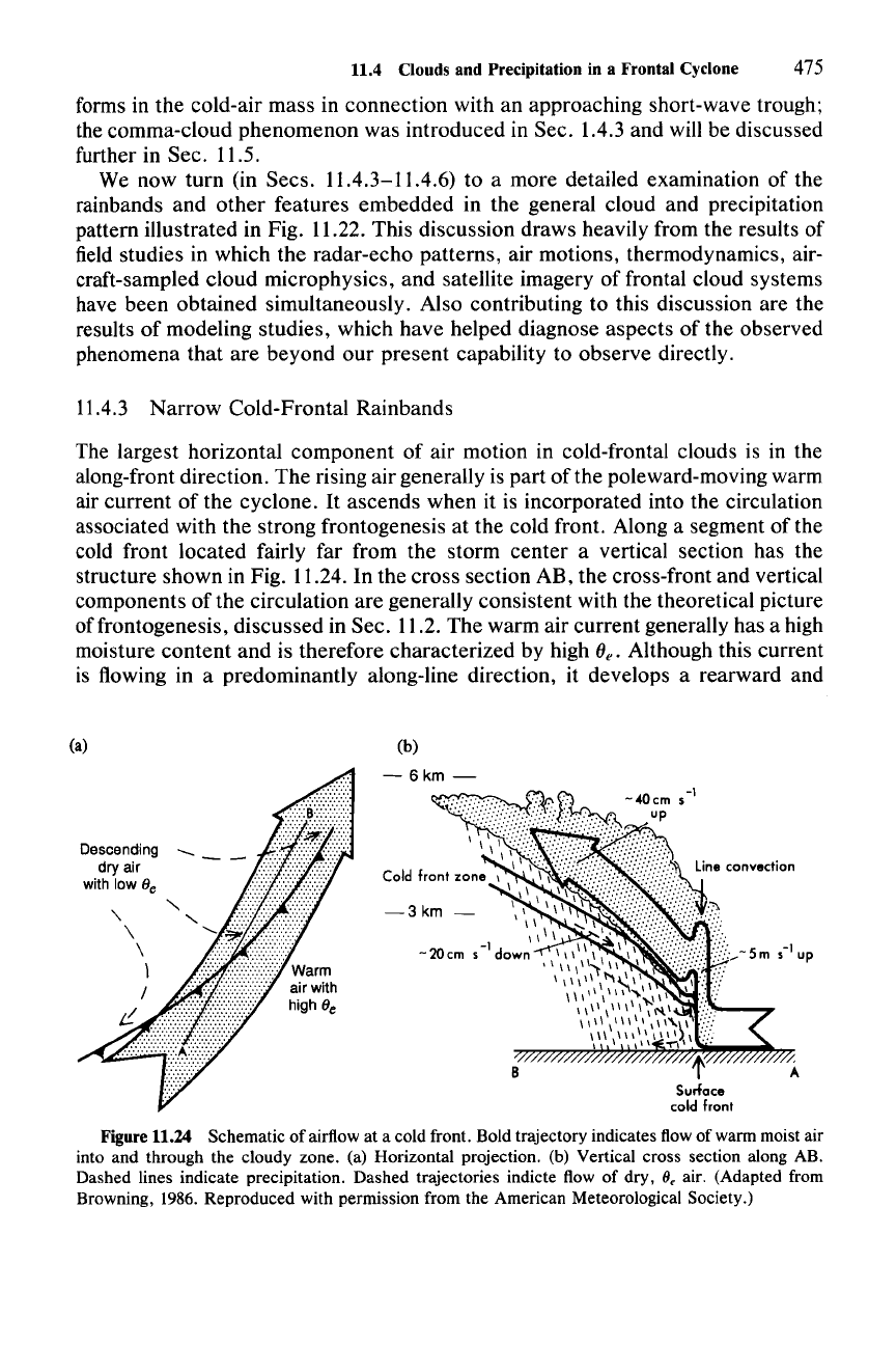
The largest horizontal component of air motion in cold-frontal clouds is in the
along-front direction. The rising air generally is part of the poleward-moving warm
air current of the cyclone.
It
ascends when it is incorporated into the circulation
associated with the strong frontogenesis at the cold front. Along a segment of the
cold front located fairly far from the storm center a vertical section has the
structure shown in Fig. 11.24. In the cross section AB, the cross-front and vertical
components of the circulation are generally consistent with the theoretical picture
offrontogenesis, discussed in Sec. 11.2. The warm air current generally has a high
moisture content and is therefore characterized by high
(}e' Although this current
is flowing in a predominantly along-line direction, it develops a rearward and
(a)
(b)
z
AB
-3km
-
Descending
___
dry air - -
with low 8
e
Surface
cold front
Figure 11.24 Schematic of airflow at a cold front. Bold trajectory indicates flow of warm moist air
into and through the cloudy zone. (a) Horizontal projection. (b) Vertical cross section along AB.
Dashed lines indicate precipitation. Dashed trajectories indicte flow of dry,
8, air. (Adapted from
Browning, 1986. Reproduced with permission from the American Meteorological Society.)
476 11 Precipitating Clouds in Extratropical Cyclones
POTENTIAL
TEMPERATURE
(K)
317
50
II
,0L.....~~u.....~~-::-L.........t-,'--'::~:-=~4:-=J-'-'-l...L.J~::w
100
500
600
Figure 11.25
Figure 11.26
Figure 11.27
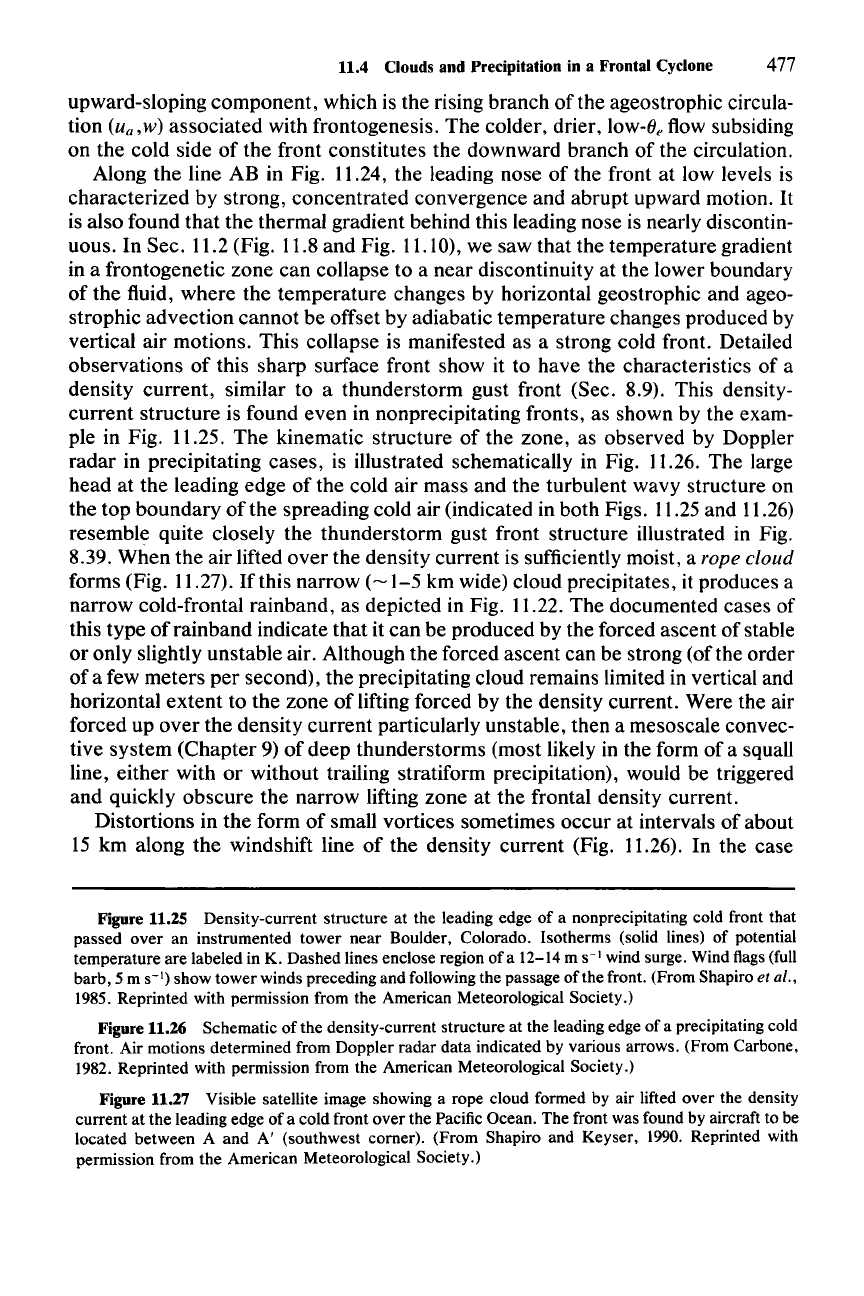
11.4 Clouds and Precipitation in a Frontal Cyclone 477
upward-sloping
component,
which is
the
rising
branch
of
the ageostrophic circula-
tion
iu; ,w)
associated
with frontogenesis.
The
colder, drier, low-e, flow subsiding
on
the
cold side
of
the
front
constitutes
the
downward
branch
of
the circulation.
Along
the
line AB in Fig. 11.24,
the
leading nose
of
the front at low levels is
characterized
by strong,
concentrated
convergence
and
abrupt
upward motion.
It
is also found
that
the
thermal gradient behind this leading nose is nearly discontin-
uous. In Sec. 11.2 (Fig. 11.8
and
Fig. 11.10), we saw
that
the temperature gradient
in a frontogenetic
zone
can
collapse to a
near
discontinuity at the lower boundary
of
the
fluid,
where
the
temperature
changes by horizontal geostrophic and ageo-
strophic
advection
cannot
be offset by adiabatic
temperature
changes produced by
vertical air motions. This collapse is manifested as a strong cold front. Detailed
observations
of
this
sharp
surface front show it to
have
the characteristics of a
density
current,
similar to a
thunderstorm
gust
front (Sec. 8.9). This density-
current
structure
is found
even
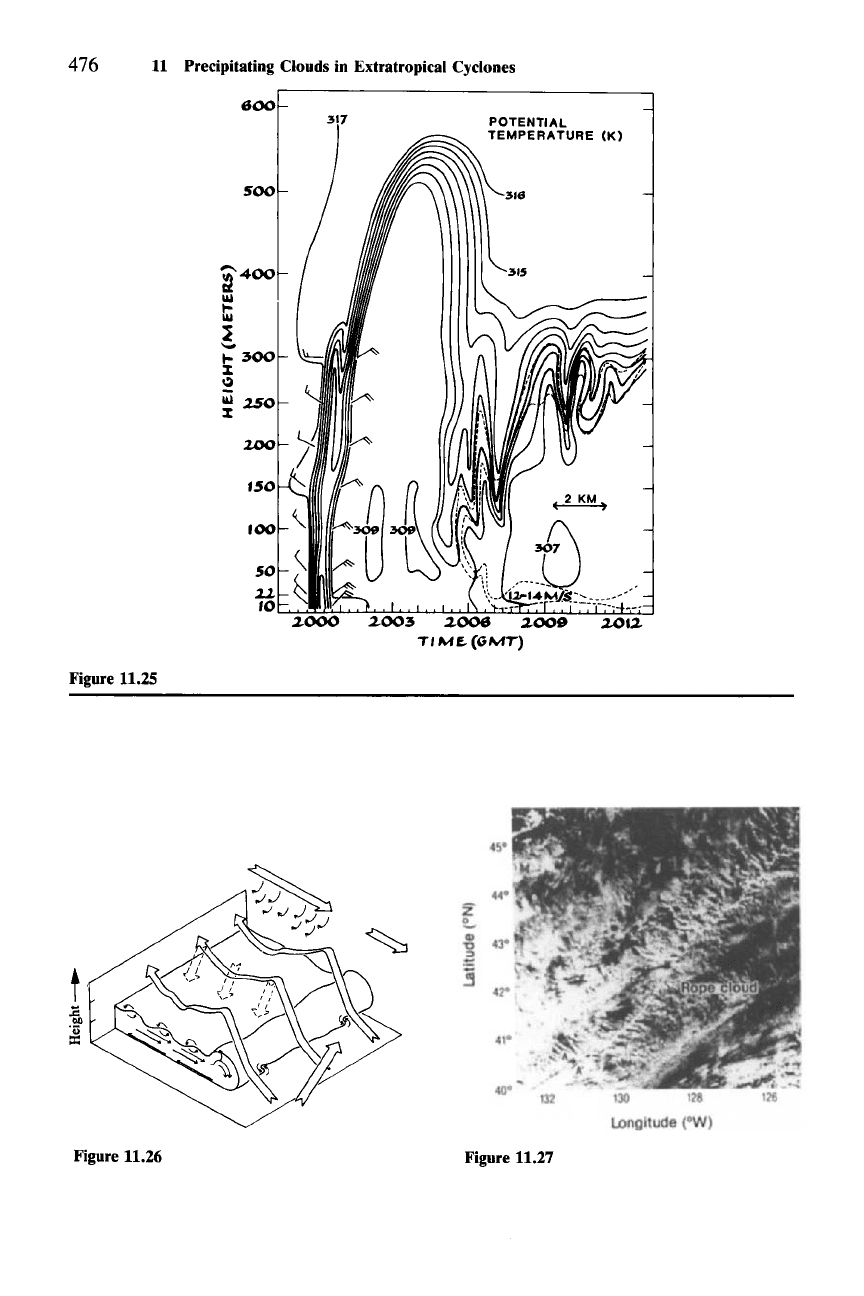
in nonprecipitating fronts, as shown by the exam-
ple in Fig. 11.25.
The
kinematic
structure
of
the
zone,
as observed by Doppler
radar
in precipitating
cases,
is illustrated schematically in Fig. 11.26.
The
large
head
at
the
leading
edge
of
the
cold air mass
and
the
turbulent wavy structure on
the
top
boundary
of
the
spreading cold air (indicated in
both
Figs. 11.25 and 11.26)
resemble quite closely
the
thunderstorm
gust front structure illustrated in Fig.
8.39.
When
the
air
lifted
over
the density
current
is sufficiently moist, a rope cloud
forms (Fig. 11.27).
Ifthis
narrow
(~1-5
km wide) cloud precipitates, it produces a
narrow
cold-frontal rainband, as depicted in Fig. 11.22.
The
documented cases of
this
type
of
rainband
indicate
that
it
can
be
produced
by the forced
ascent
of stable
or
only slightly
unstable
air. Although
the
forced
ascent
can
be strong (of the
order
of
a few
meters
per
second),
the
precipitating cloud remains limited in vertical and
horizontal
extent
to
the
zone
of
lifting forced by the density current. Were the air
forced up
over
the
density
current
particularly unstable,
then
a mesoscale convec-
tive
system
(Chapter
9)
of
deep
thunderstorms
(most likely in the form
of
a squall
line,
either
with
or
without
trailing stratiform precipitation), would be triggered
and
quickly
obscure
the
narrow
lifting zone at
the
frontal density current.
Distortions in
the
form
of
small vortices sometimes
occur
at intervals
of
about
15 km along
the
windshift line
of
the
density
current
(Fig. 11.26). In the case
Figure 11.25 Density-current structure at the leading edge of a nonprecipitating cold front that
passed over an instrumented tower near Boulder, Colorado. Isotherms (solid lines) of potential
temperature are labeled in K. Dashed lines enclose region
ofa
12-14 m
S-I
wind surge. Wind flags (full
barb, 5 m
S-I)
show tower winds preceding and following the passage
ofthe
front. (From Shapiro et al.,
1985.
Reprinted with permission from the American Meteorological Society.)
Figure 11.26 Schematic of the density-current structure at the leading edge of a precipitating cold
front. Air motions determined from Doppler radar data indicated by various arrows. (From Carbone,
1982. Reprinted with permission from the American Meteorological Society.)
Figure 11.27 Visible satellite image showing a rope cloud formed by air lifted over the density
current at the leading edge of a cold front over the Pacific Ocean. The front was found by aircraft to be
located between A and A' (southwest comer). (From Shapiro and Keyser,
1990. Reprinted with
permission from the American Meteorological Society.)
478 11 Precipitating Clouds in Extratropical Cyclones
represented in Fig. 11.26, a weak tornado occurred in association with one of the
vortices along the narrow cold-frontal rainband.P' The kinematic structure of the
vortex was generally similar to a tornadic thunderstorm (probably of the nonsu-
percell type discussed in Sec. 8.7). However, the thermodynamic structure indi-
cated by soundings and Doppler radar retrieval analysis revealed no potential
instability of the air forced to rise at the front. This tornadic storm thus differs in
one important way from the tornadic thunderstorms produced in thermodynami-
cally unstable environments (Chapter 8). In both cases, the density current plays
the role of generating horizontal vorticity via the horizontal buoyancy gradient
across its leading edge. However, the source of the density current is entirely
different in the two cases. In the thunderstorms discussed in Chapter 8, buoyant
instability is required for the formation of downdrafts, which spread out and form
a gust front. In the case of the narrow cold-frontal band, the density current is
apparently the result of strong low-level frontogenesis producing a nearly discon-
tinuous thermal gradient at the
earth's
surface. While this density current may
sporadically propagate independently, its generally forward progress is deter-
mined primarily by larger-scale dynamics and only secondarily by convective
downdrafts.
The occurrence of a tornado along a narrow cold-frontal rainband is rare.
However, the perturbed structure of the narrow band, from which the tornado
occasionally arises, is quite common. Figure 11.28shows the radar echo structure
of four different narrow cold-frontal rainbands observed along the Washington
coast in a period of less than 1 month. Each narrow cold-frontal rainband exhibits
small-scale radar echoes oriented oblique to the mean position of the cold front.
Doppler radar observations reveal that these small elongated cells are related
systematically to the distortions of the windshift line (Fig. 11.29).The distortion of
the windshift lines results in maximum low-level convergence along the portion of
the line where the elongated precipitation core is located, while strong cyclonic
shear occurs in the gap region. The tornado described above evidently formed at
the point of maximum cyclonic shear.
It
has been suggested that the distortion of the windshift line along the cold
front is a manifestation of some sort of instability that arises in connection with
the horizontal wind shear across the front.v"
It
might also be associated with
bulges and clefts of the type that are observed in density currents in laboratory
tank experiments.P" Whatever the origin of the distortions, their effect on the
clouds and precipitation once they have formed can be seen from a diagram like
that in Fig. 11.30. In Fig. 11.30a, the wind along an initially undisturbed front has
302 This tornado was discovered by Carbone (1983) and described by him in some detail. He
analyzed the vorticity budget and made comparisons to tornadic thunderstorms.
303 Suggested by Matejka (1980), Carbone (1982, 1983), and Hobbs and Persson (1982). See these
papers for more detailed discussion of this hypothesis. A similar suggestion was made by Wakimoto
and Wilson (1989)
to explain the vorticity centers long the boundary layer convergence Jines
over
which nonsupercel1 tornadoes form (Sec. 8.7).
304 The bulges and clefts in laboratory density currents are discussed and il1ustrated by Simpson
(1987, pp. 150-153). The analogy between them and the distortions in the windshift line along a surface
cold front was suggested by Hobbs and Persson (1982) as a possible alternative to an instability
associated with the horizontal
shear
across the line.
