Houze Robert A., Jr. Cloud Dynamics
Подождите немного. Документ загружается.

11.4 Clouds and Precipitation in a Frontal Cyclone 479
~
015dbZ
e30
dbZ
(d)
•
\
L....J
20 km
~
q
I
f
~
025
dbZ
e 30 dbZ
(c)
L-l
20km
030
dbZ
e 35 dbZ
(
b)
L.......J
20 km
L.......J
030
dbZ
20
km
e35
dbZ
(0)
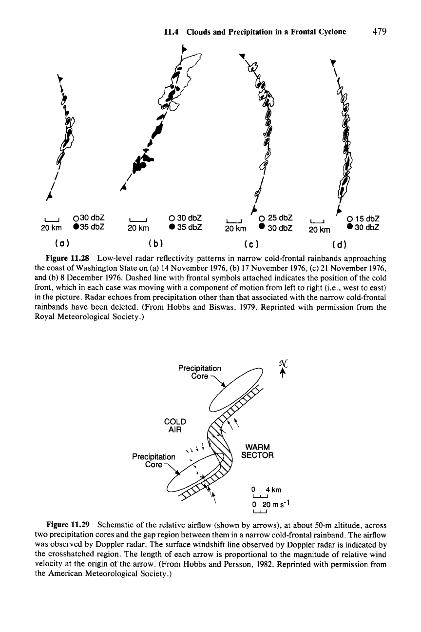
Figure 11.28 Low-level radar reflectivity patterns in narrow cold-frontal rainbands approaching
the coast of Washington State on (a) 14 November 1976, (b) 17 November 1976, (c) 21 November 1976,
and (b) 8 December 1976. Dashed line with frontal symbols attached indicates the position of the cold
front, which in each case was moving with a component of motion from left to right (i.e., west to east)
in the picture. Radar echoes from precipitation other than that associated with the narrow cold-frontal
rainbands have been deleted. (From Hobbs and Biswas, 1979. Reprinted with permission from the
Royal Meteorological Society.)
preCiPitat~
coce{§
COLD
AIR
WARM
SECTOR
o
4km
L....L.....J
o 20 m 5-
1
LJ.....J
Figure 11.29 Schematic of the relative airflow (shown by arrows), at about 50-m altitude, across
two precipitation cores and the gap region between them in a narrow cold-frontal rainband. The airflow
was observed by Doppler radar. The surface windshift line observed by Doppler radar is indicated by
the crosshatched region. The length of each arrow is proportional to the magnitude of relative wind
velocity at the origin of the arrow. (From Hobbs and Persson, 1982. Reprinted with permission from
the American Meteorological Society.)
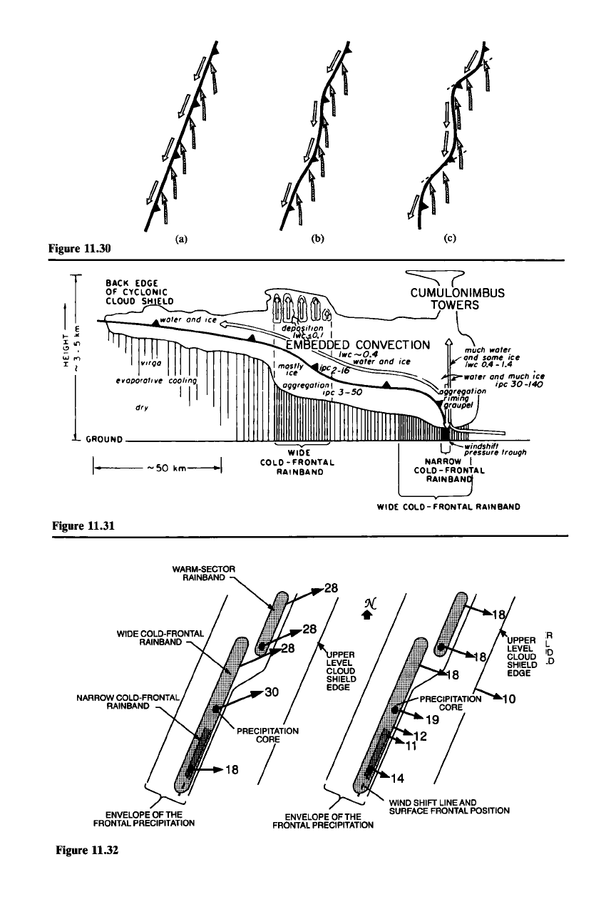
Figure 11.30
(a)
(b)
(c)
coolIng
I
II
I·
-SOkm-1
,1
...
'"
:I: on
o
w'"
:I: I
1
ev
aoorotive
dry
GROUNO
--LllJ.J.J..L
'---y-------"
WIDE
COLD - FRONTAL
RAINBANO
Figure 11.31
u
:t~~:~1~
trough
NARROW
I
COLD- FRONTAL
RAINBAN
WIDE COLD- FRONTAL RAIN
BAND
WARM-SECTOR
RAINBAND
ENVELOPEOF THE
FRONTAL
PRECIPITATION
Figure 11.32
ENVELOPEOF THE
FRONTAL
PRECIPITATION
WINDSHIFTLINEAND
SURFACE
FRONTAL
POSITION
R
L
10
_0
11.4 Clouds and Precipitation in a Frontal Cyclone
481
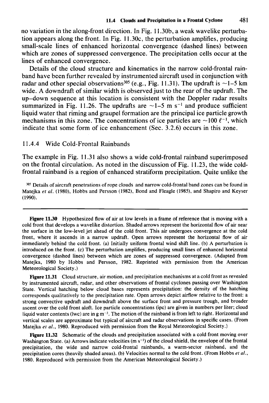
no variation in the along-front direction. In Fig. 11.30b, a weak wavelike perturba-
tion appears along the front. In Fig. 11.30c, the perturbation amplifies, producing
small-scale lines of enhanced horizontal convergence (dashed lines) between
which are zones of suppressed convergence. The precipitation cells occur at the
lines of enhanced convergence.
Details of the cloud structure and kinematics in the narrow cold-frontal rain-
band have been further revealed by instrumented aircraft used in conjunction with
radar and other special observations-" (e.g., Fig. 11.3l). The updraft is
-1-5
km
wide. A downdraft of similar width is observed
just
to the rear of the updraft. The
up-down
sequence at this location is consistent with the Doppler radar results
summarized in Fig. 11.26. The updrafts are
-1-5
m
S-I
and produce sufficient
liquid water that riming and graupel formation are the principal ice particle growth
mechanisms in this zone. The concentrations of ice particles are
-100
£-1,
which
indicate that some form of ice enhancement (Sec. 3.2.6) occurs in this zone.
11.4.4 Wide Cold-Frontal Rainbands
The example in Fig.
11.31
also shows a wide cold-frontal rainband superimposed
on the frontal circulation. As noted in the discussion of Fig. 11.23, the wide cold-
frontal rainband is a region of enhanced stratiform precipitation. Quite unlike the
305 Details of aircraft penetrations of rope clouds and narrow cold-frontal band zones can be found in
Matejka
et al. (1980), Hobbs and Persson (1982), Bond and Fleagle (1985), and Shapiro and Keyser
(1990).
Figure 11.30 Hypothesized flow of air at low levels in a frame of reference that is moving with a
cold front that develops a wavelike distortion. Shaded arrows represent the horizontal flow of air near
the surface in the low-level
jet
ahead of the cold front. This air undergoes convergence at the cold
front, where it ascends in a narrow updraft. Open arrows represent the horizontal flow of air
immediately behind the cold front. (a) Initially uniform frontal wind shift line. (b) A perturbation is
introduced on the front. (c) The perturbation amplifies, producing small lines of enhanced horizontal
convergence (dashed lines) between which are zones of suppressed convergence. (Adapted from
Matejka,
1980 by Hobbs and Persson, 1982. Reprinted with permission from the American
Meteorological Society.)
Figure 11.31 Cloud structure, air motion, and precipitation mechanisms at a cold front as revealed
by instrumented aircraft, radar, and other observations of frontal cyclones passing over Washington
State. Vertical hatching below cloud bases represents precipitation: the density of the hatching
corresponds qualitatively to the precipitation rate. Open arrows depict airflow relative to the front: a
strong convective updraft and downdraft above the surface front and pressure trough, and broader
ascent over the cold front aloft. Ice particle concentrations (ipc) are given in numbers per liter; cloud
liquid water contents (lwc) are in g m-
3
• The motion of the rainband is from left to right. Horizontal and
vertical scales are approximate but typical of aircraft and radar observations in specific cases. (From
Matejka et al., 1980. Reproduced with permission from the Royal Meteorological Society.)
Figure 11.32 Schematic of the clouds and precipitation associated with a cold front moving over
Washington State. (a) Arrows indicate velocities (m
S-I)
of the cloud shield, the envelope of the frontal
precipitation, the wide and narrow cold-frontal rainbands, a warm-sector rainband , and the
precipitation cores (heavily shaded areas). (b) Velocities normal to the cold front. (From Hobbs
et al.,
1980. Reproduced with permission from the American Meteorological Society.)
482 11 Precipitating Clouds in Extratropical Cyclones
narrow cold-frontal band, its most active region
of
upward motion is aloft, above
the front, and is only very indirectly connected with processes near the
earth's
surface. The wide cold-frontal band
rather
appears to emanate from a layer aloft,
which is characterized by enhanced mean ascent.
In addition to enhanced mean ascent, the wide cold-frontal rainband contains
shallow convective generating cells (Sec. 6.2). The precipitation particles gener-
ated in these cells
are
thought to augment the general stratiform precipitation rate
at lower levels by the
feeder-seeder
mechanism, as they fall through the lower
layers of frontal cloud (Fig. 6.7). Figure 11.31 indicates almost no liquid water
present in the lower levels of the cloud of the wide cold-frontal rainband. An ice
particle concentration -
3-50
£-1 is large enough to indicate that some form of ice
enhancement (Sec. 3.2.6) was occurring here, as well as in the narrow
band.t'"
The particles were growing by aggregation
just
above the melting layer, as is usual
for stratiform precipitation (Sees. 6.1-6.3).
The wide cold-frontal band moves with the winds in the layer of enhanced
vertical air motion
and
generating cells. This motion is independent of the narrow
cold-frontal band, which moves with the surface cold front. The wide cold-frontal
band appears to be generated in a position similar to that shown in Fig. 11.31.
However, it
can
move faster than the front, sometimes ending up ahead of the
position of the front at the surface. As it moves forward in this way, the wide cold-
frontal rainband sometimes temporarily straddles the narrow cold-frontal band
(Fig. 11.32).
The
formation and movement of the wide cold-frontal band thus
suggest that while the frontal system provides a favorable environment for its
formation, its dynamics are somewhat separable from the frontal dynamics. In
this respect, the wide cold-frontal bands differ strikingly from the narrow cold-
frontal rainband, which is anchored to the dynamics
of
the cold front at low levels.
The time and space scales of the wide cold-frontal rainband are smaller than
those
of
the frontal system as a whole. Multiple wide cold-frontal rainbands
can
occur within the space and time domain of a single cold-frontal system (e.g., Figs.
11.22 and 11.23). Their essential dynamics are superimposed on the larger fronto-
genetical circulation. As suggested by Fig. 11.31, the enhanced mean ascent ap-
pears to be associated with a local, probably transient steepening
of
the frontal
slope.P? Whether the steepening
of
the front in this location is a cause or effect of
the rainband is
not
clear. That it could be the latter is suggested by the fact that
evaporation
and
melting of the precipitation particles falling from an established
wide cold-frontal rainband cloud into the unsaturated air below the front could
introduce the horizontal gradient of heating into (11.64) that would locally en-
hance the frontogenetic circulation.
308
There is evidence
that
some wide cold-frontal rainbands are a manifestation
of
conditional symmetric instability (Sec. 2.9.1).309 This possibility is illustrated by
306 See Matejka et al. (1980) for details of the data obtained on the aircraft penetration.
307 The steepening of the slope of the front in the vicinity of wide cold-frontal rainbands has been
examined more recently by Locatelli
et al. (1992).
308 Locatelli et aI. (1992), however, take the position that it is cause rather than effect.
309 The possibility that rainbands in frontal systems could be manifestations of moist symmetric
instability was suggested by Hoskins (1974) and Bennetts and Hoskins (1979).
11.4 Clouds and Precipitation in a Frontal Cyclone 483
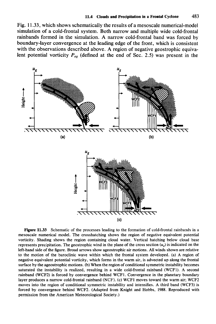
Fig. 11.33, which shows schematically the results of a mesoscale numerical-model
simulation of a cold-frontal system. Both narrow and multiple wide cold-frontal
rainbands formed in the simulation. A narrow cold-frontal band was forced by
boundary-layer convergence at the leading edge of the front, which is consistent
with the observations described above. A region of negative geostrophic equiva-
lent potential vorticity
Peg
(defined at the end of Sec. 2.5) was present in the
i
J
(a)
(b)
i
J
(c)
Figure 11.33 Schematic of the processes leading to the formation of cold-frontal rainbands in a
mesoscale numerical model. The crosshatching shows the region of negative equivalent potential
vorticity. Shading shows the region containing cloud water. Vertical hatching below cloud base
represents precipitation. The geostrophic wind in the plane of the cross section
(u
g
)
is indicated on the
left-hand side of the figure. Broad arrows show ageostrophic air motions. All winds shown are relative
to the motion of the baroclinic wave within which the frontal system developed. (a) A region of
negative equivalent potential vorticity, which forms in the warm air, is advected up along the frontal
surface by the ageostrophic motions. (b) When the region of conditional symmetric instability becomes
saturated the instability is realized, resulting in a wide cold-frontal rainband (WCFt). A second
rainband (WCF2) is forced by convergence behind WCFI. Convergence in the planetary boundary
layer produces a narrow cold-frontal rainband (NCF). (c) WCFI moves toward the warm air; WCF2
moves into the region of conditional symmetric instability and intensifies. A third band (WCF3) is
forced by convergence behind WCF2. (Adapted from Knight and Hobbs, 1988. Reproduced with
permission from the American Meteorological Society.)

484 11 Precipitating Clouds in Extratropical Cyclones
boundary layer. As noted in 2.9.1, the condition Peg < 0 is the criterion for
potential symmetric instability. The region of negative
Peg
in the boundary layer of
the model case was partly present in the initial conditions and partly created in the
boundary layer in connection with (parameterized) turbulence. The first wide
cold-frontal band (WCFt) forms when the region of negative
Peg is lifted by the
frontal circulation to saturation. Once the region is saturated, the potential sym-
metric instability can be released. The enhanced vertical motion arising from the
release of the instability intensifies the precipitation, thus creating the rainband in
the precipitation pattern. The second wide cold-frontal band (WCF2) arises differ-
ently from
WCFl.
It
is forced by convergence behind WCFl at a somewhat higher
altitude.
WCFl
moves toward the warm air faster than the front. WCF2 moves
into the region of negative
Peg, where it intensifies, presumably as conditional
symmetric instability is released. WCF3 is forced by convection behind and fol-
lows a life cycle similar to WCF2.
From the foregoing discussions, it appears that the enhancement of the strati-
form precipitation in the wide cold-frontal rainbands is effected microphysically
by generating cells aloft and the feeder-seeder process (Fig. 11.31) and dynami-
cally by the enhancement of the mean upward air motion by the release of poten-
tial symmetric instability (Fig.ll.33). Other factors such as frontal slope may also
be important.
11.4.5 Warm-Frontal Rainbands
The warm-frontal rainbands indicated in Fig. 11.22are similar in dimension to the
wide cold-frontal rainbands. They differ in that they occur in the forward part of
the cloud shield of the developing cyclone, where warm advection dominates,
rather than in the trailing part where cold advection dominates. They tend to be
parallel to the isotherms in that part of the storm,
just
as the wide cold-frontal
bands tend to be parallel to the isotherms in their part of the storm. In this
subsection, we will examine some actual examples illustrating the kinematics and
microphysics of warm-frontal rainbands.
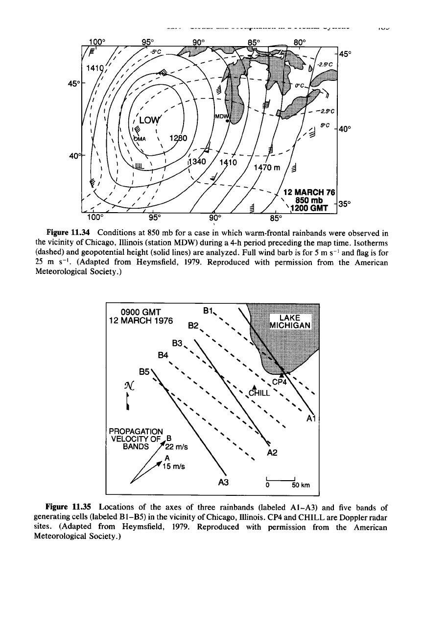
The 850-mb isotherms and geopotential height pattern for the first example are
shown in Fig. 11.34. The rainbands were observed in the vicinity of station MDW
during a 4-h period preceding the map time. The locations of the axes of three
rainbands (labeled
AI,
A2, and A3) 3 h before the map time are shown by the solid
lines in Fig. 11.35. The dashed lines labeled B
1-
B5 show the positions of five lines
of generating cells (Sec. 6.2) situated between 5 and 6 km altitude. The generating
cells, located above the rainbands, were of the type described in Sec. 6.2. They
moved over the lower-level rainbands and seeded them with ice particles in the
manner illustrated in the example of stratiform rain shown in Fig. 6.8. That exam-
ple was taken from a warm-frontal rainband, and the precipitation mechanisms
were illustrated in Figs. 6.8-6.10, where it was seen that a mesoscale region of
enhanced updraft at lower levels was seeded from above by the generating cells.
These mechanisms typify the precipitation processes in warm-frontal rainbands.
------
---- - -
---r-~------
---
- - -------
-oJ
------
S'C
12 MARCH 76
, 850 mb 350
'1200
GMT
Figure 11.34 Conditions at 850 mb for a case in which warm-frontal rainbands were observed in
the vicinity of Chicago, Illinois (station MDW) during a 4-h period preceding the map time. Isotherms
(dashed) and geopotential height (solid lines) are analyzed. Full wind barb is for 5 m
S-I
and flag is for
25 m
S-I.
(Adapted from Heymsfield, 1979. Reproduced with permission from the American
Meteorological Society.)
A1
A2
L-...--...J
o 50km
A3
82
,
,
,
,
,
,
,
,
,
, ,
,
',CP4,
'A
,
,
CHILL',
'
, ,
, ,
" '
,
,
,
85
PROPAGATION
VELO?CITY
OF B
BANDS 22
mls
A
15 rn/s
0900
GMT
12 MARCH 1976
Figure 11.35 Locations of the axes of three rainbands (labeled AI-A3) and five bands of
generating cells (labeled
BI-B5)
in the vicinity of Chicago, Illinois. CP4 and CHILL are Doppler radar
sites. (Adapted from Heymsfield, 1979. Reproduced with permission from the American
Meteorological Society.)
486 11 Precipitating Clouds in Extratropical Cyclones
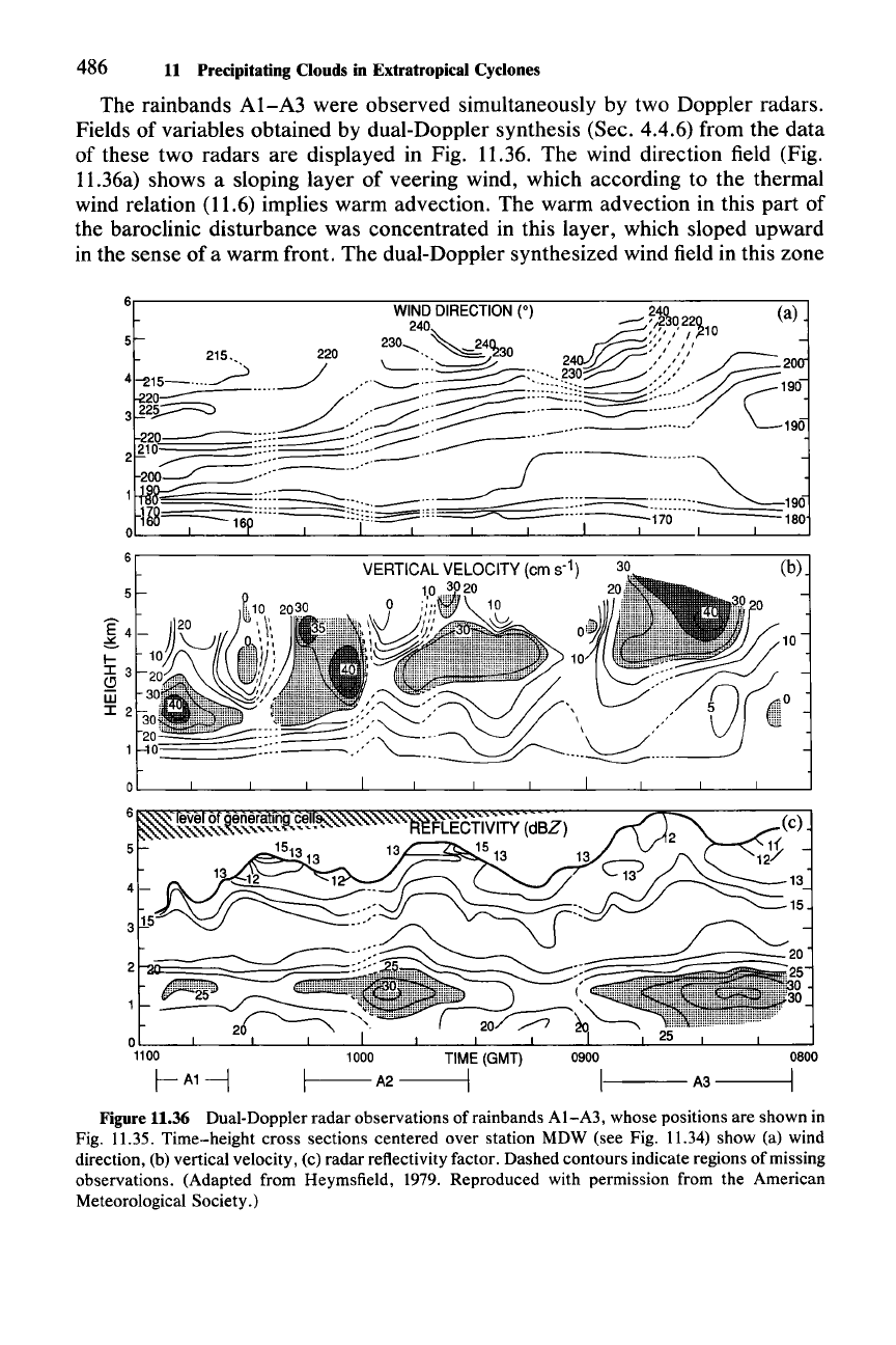
The rainbands
AI-A3
were observed simultaneously by two Doppler radars.
Fields of variables obtained by dual-Doppler synthesis (Sec. 4.4.6) from the data
of these two radars are displayed in Fig. 11.36. The wind direction field (Fig.
11.36a) shows a sloping layer of veering wind, which according to the thermal
wind relation (11.6) implies warm advection. The warm advection in this part of
the baroclinic disturbance was concentrated in this layer, which sloped upward
in the sense
of
a warm front. The dual-Doppler synthesized wind field in this zone
0800
I
(b)
0900
I
TIME
(GMT)
I
1000
1----
A2
----I
°1L10::-:cO---'----'-----I.---'------l.--....L----JL---L--L-..:=------l.--...l----J
r-
A1-1
6,-----------------------------------,
~
4-
l-
I 3
~
W
I 2
Figure 11.36 Dual-Doppler radar observations of rainbands
AI-A3,
whose positions are shown in
Fig. 11.35. Time-height cross sections centered over station MDW (see Fig. 11.34) show (a) wind
direction, (b) vertical velocity, (c) radar reflectivity factor. Dashed contours indicate regions of missing
observations. (Adapted from Heymsfield, 1979. Reproduced with permission from the American
Meteorological Society.)
11.4 Clouds and Precipitation in a Frontal Cyclone 487
was found to be frontogenetic.l'" A sloping zone of upward motion was found
within the layer of warm advection, as is expected from the large-scale omega
equation (11.14) and illustrated by Fig. 11.3b. In addition, the vertical velocity is
enhanced in three mesoscale zones, where the maximum upward velocity exceeds
40 em s
:'
and the region of ascent extends upward out of the concentrated layer
of warm advection. These three regions of enhanced ascent seem to correspond to
the three rainbands
AI-A3,
each rainband exhibiting its peak reflectivity some-
what downstream (to the right) of the corresponding region of enhanced upward
motion (cf. Fig. 11.36b and c).
The relation between the vertical motion and the radar reflectivity fields in Fig.
11.36 is subject to some uncertainty. The upward motion in Fig. 11.36b was
calculated by substituting the divergence of the Doppler-synthesized wind field
into the anelastic continuity equation (2.54). As discussed in Sec. 4.4.6, this
procedure is especially prone to error in cases such as this one, in which the echo
top is not at a level where an upper-boundary condition on the vertical velocity
can be established. Hence, the vertical velocity field in Fig. 11.36b is only a rough
estimate. Also, the time scale of the fallout of the ice particles growing in the
upward motion zones, the wind velocity relative to the rainbands, and the life-
times of the rainbands must all be commensurate for there to be a one-to-one
correspondence between the rainbands and the three areas of enhanced upward
motion. Variability in a direction perpendicular to the cross sections in Fig. 11.36
is another source of uncertainty. Nonetheless, the mesoscale regions of enhanced
vertical motion are similar in size to the rainbands, and each rainband appears to
have been associated with such a zone of vertical motion.
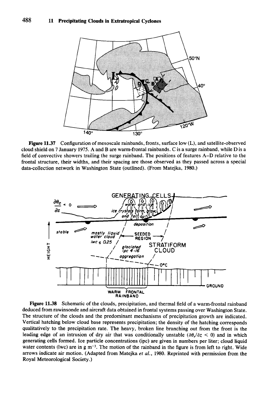
The final example of a warm-frontal rainband is the feature A positioned in the
forward portion of the cloud shield of the frontal cyclone as shown in Fig. 11.37. A
schematic
ofthe
clouds, precipitation, and thermal field deduced from rawinsonde
and aircraft data is shown in Fig. 11.38. An intrusion of dry air aloft above the
main cloud deck created a layer of potential instability
(aoe/az
< 0; see Sec. 2.9.1).
It
is suggested that the generating cells were triggered in this layer as a result of
the vertical motion in the layer of warm advection below."! Aircraft measure-
ments below the layer of cells
312
indicate that the seeded region was glaciated. In
contrast, the region of cloud adjacent to the seeded zone exhibited measurable
amounts of liquid water. The ice particles were present in concentrations of 4-16
e-
1
,
similar to the concentrations seen in wide cold-frontal rainbands (Fig. 11.31).
Also similar to the wide cold-frontal bands, the particles were growing by aggrega-
tion in the region
just
above the melting layer.
The dynamical mechanism leading to the enhanced vertical air motions in
warm-frontal rainbands (Fig. 6.9, Fig. 11.36b) has not been clearly identified.
They may be produced by symmetric instability, as appears to be the case for
some wide cold-frontal rainbands (Sec. 11.4.3). However, this has not yet been
310 See Heymsfield (1979) for details.
311 This mechanism was postulated by Kreitzberg and Brown (1970).
312 See Matejka et al. (1980) for details.
488
11 Precipitating Clouds in Extratropical Cyclones
Figure 11.37 Configuration of mesoscale rainbands, fronts, surface low (L), and satellite-observed
cloud shield on 7 January 1975.A and B are warm-frontal rainbands. C is a surge rainband, while D is a
field of convective showers trailing the surge rainband. The positions of features
A-D
relative to the
frontal structure, their widths, and their spacing are those observed as they passed across a special
data-collection network in Washington State (outlined). (From Matejka, 1980.)
•
stabt«
WARM FRONTAL
RAINBAND
Figure 11.38 Schematic of the clouds, precipitation, and thermal field of a warm-frontal rainband
deduced from rawinsonde and aircraft data obtained in frontal systems passing over Washington State.
The structure of the clouds and the predominant mechanisms of precipitation growth are indicated.
Vertical hatching below cloud base represents precipitation; the density of the hatching corresponds
qualitatively to the precipitation rate. The heavy, broken line branching out from the front is the
leading edge of an intrusion of dry air that was conditionally unstable (a8,laz
< 0) and in which
generating cells formed. Ice particle concentrations (ipc) are given in numbers per liter; cloud liquid
water contents (lwc) are in g m-
3
•
The motion of the rainband in the figure is from left to right. Wide
arrows indicate air motion. (Adapted from Matejka
et al., 1980. Reprinted with permission from the
Royal Meteorological Society.)
