Houze Robert A., Jr. Cloud Dynamics
Подождите немного. Документ загружается.

9.2 The Squall Line with Trailing Stratiform Precipitation 379
location within the stratiform region.P? The upward velocity of
~
10 em s-I near
the ground in curve 2 appears because this profile was taken in the vicinity of the
wake low (Sec. 9.2.3.5).
The association of the mesoscale downdraft with the melting layer is seen in
another way in Fig. 9.41. Panel a displays areal mean vertical velocity profiles for
both the convective and stratiform regions of the same mesoscale convective
system for which vertical profiles for specific locations are shown in Fig. 9.40. In
panel b of Fig. 9.41, the stratiform region profile is decomposed into three subre-
gions. Curves A and B represent the core of heaviest stratiform precipitation
(located in the
"secondary
maximum" of radar echo in the trailing stratiform
region, as described schematically in Fig. 9.9, Sec. 9.1.2.2). They represent the
region of stratiform precipitation with low-level radar reflectivity exceeding 25
dBZ for at least 2.5 h. This precipitation is that lying directly under the strong
radar bright band seen in Fig. 9.31. Curve A is for the heaviest stratiform rain
within this zone (radar echo >35
dBZ
for more than 1.5 h), while curve B repre-
sents core stratiform rain of more intermediate intensity (25-35
dBZfor
more than
2.5 h). Curve C is for the lighter stratiform region lying outside the secondary
maximum.
From
these three curves it is seen that the mesoscale downdraft is
concentrated within the zone of heaviest stratiform rain, namely that associated
with the well-defined melting layer marked by the bright band (curves A and B).
The mesoscale downdraft disappears in the average outside of the core of heavy
stratiform rain (curve C). At the same time, the mesoscale updraft appears with
the same intensity in all three subregions. Evidently, the horizontal scale of the
mesoscale downdraft is set by the width of the region of strong melting, while the
mesoscale updraft at higher levels is of a larger horizontal scale.
It
extends rather
uniformly across the entire stratiform region, as the positively buoyant air from
the upper reaches of the convective regions is spread across the stratiform region
by the front-to-rear flow at upper levels.
259 See Sec. 4a of Houze (1989) for further examples, including vertical profiles of w inferred from
sounding analysis, Doppler radar, and profiler measurements in tropical, midlatitude, continental, and
oceanic mesoscale convective systems.
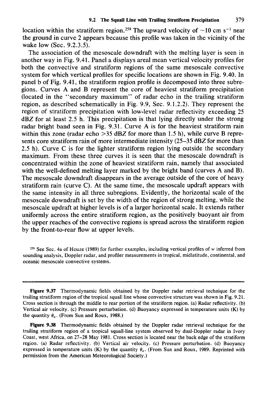
Figure 9.37 Thermodynamic fields obtained by the Doppler radar retrieval technique for the
trailing stratiform region of the tropical squall line whose convective structure was shown in Fig.
9.21.
Cross section is through the middle to rear portion of the stratiform region. (a) Radar reflectivity. (b)
Vertical air velocity. (c) Pressure perturbation. (d) Buoyancy expressed in temperature units (K) by
the quantity
(Jo' (From Sun and Roux, 1988.)
Figure 9.38 Thermodynamic fields obtained by the Doppler radar retrieval technique for the
trailing stratiform region of a tropical squall-line system observed by dual-Doppler radar in Ivory
Coast, west Africa, on
27-28
May 1981. Cross section is located near the back edge of the stratiform
region. (a) Radar reflectivity. (b) Vertical air velocity. (c) Pressure perturbation. (d) Buoyancy
expressed in temperature units (K) by the quantity
(Jo' (From Sun and Roux, 1989. Reprinted with
permission from the American Meteorological Society.)
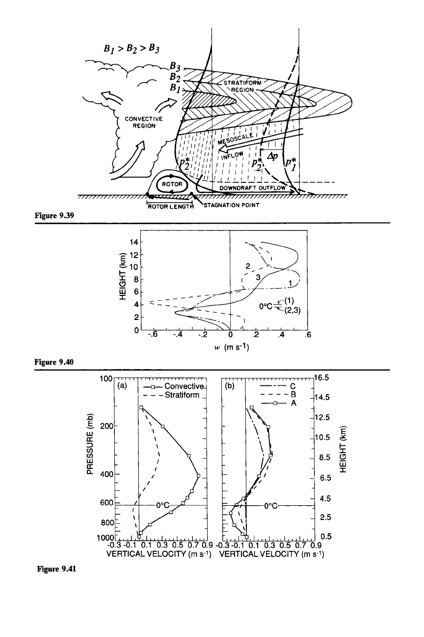
Figure 9.39
.6.4
o .2
w
(ms-
1
)
-.4
I
~
-=:
::
- - - -
~/-:----
-.6
14
E 12
c10
I-
a 8
iii 6
I
4
2
o
'---j,;---'-----7---'-----:,----'-"-7--'-'-----±----'--.l~.L..-...J.
Figure 9.40
100
(a)
-0-
Convectiv
- - - Stratiform
:c
\
.s
200
\
W
\
a:
\
::>
\
(/)
\
(/)
W
I
a:
I
c,
400
/
/
/
600
800
1000
Figure 9.41
16.5
(b)
---C
----8
14.5
--0--
A
12.5
E
10.5
c
l-
I
8.5
Cl
iii
I
-
6.5
4.5
2.5
9.2 The Squall Line with Trailing Stratiform Precipitation
381
9.2.3.4 Kinematic
and
Thermodynamic Structure at the
Top
of
the Stratiform Cloud
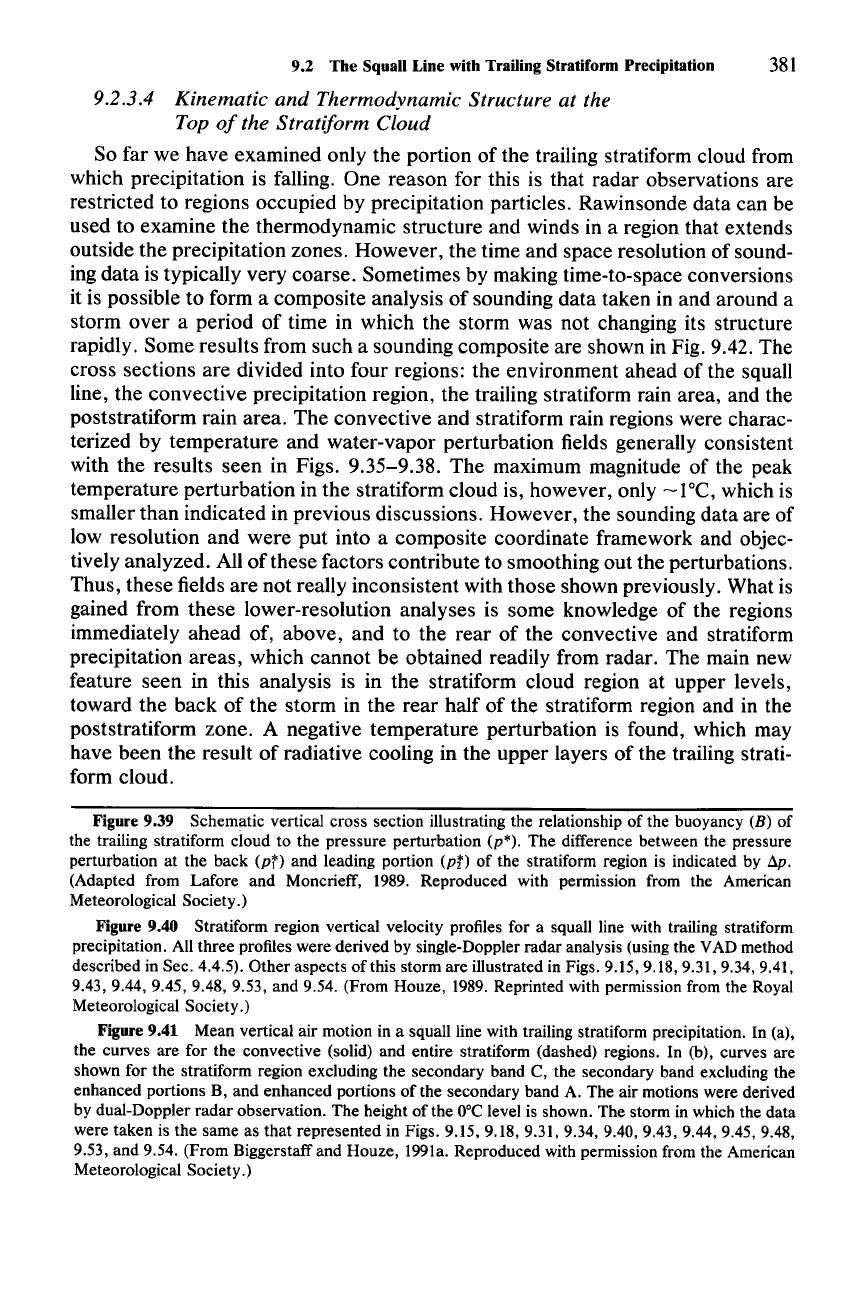
So far we have examined only the portion of the trailing stratiform cloud from
which precipitation is falling. One reason for this is that radar observations are
restricted to regions occupied by precipitation particles. Rawinsonde data can be
used to examine the thermodynamic structure and winds in a region that extends
outside the precipitation zones. However, the time and space resolution of sound-
ing data is typically very coarse. Sometimes by making time-to-space conversions
it is possible to form a composite analysis of sounding data taken in and around a
storm over a period of time in which the storm was not changing its structure
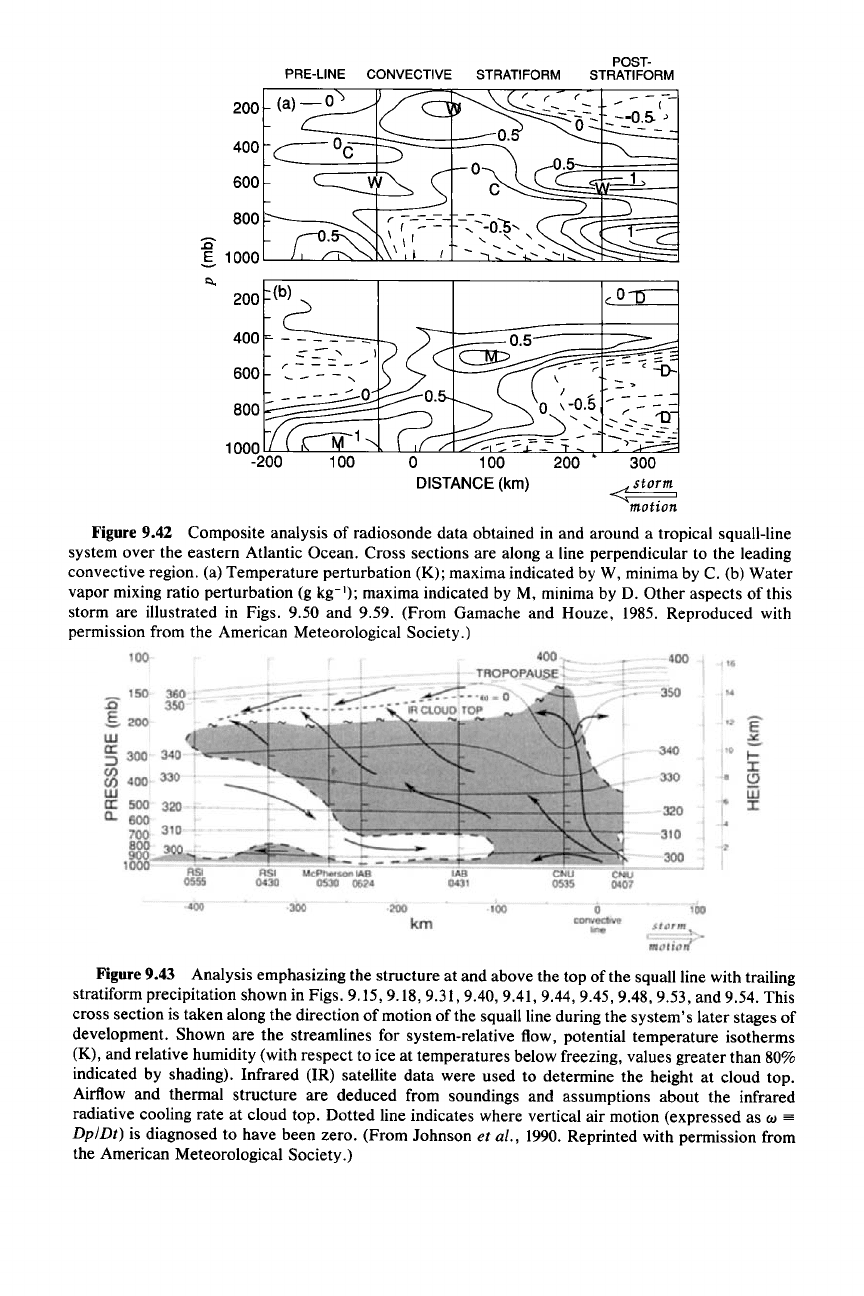
rapidly. Some results from such a sounding composite are shown in Fig. 9.42. The
cross sections are divided into four regions: the environment ahead of the squall
line, the convective precipitation region, the trailing stratiform rain area, and the
poststratiform rain area. The convective and stratiform rain regions were charac-
terized by temperature and water-vapor perturbation fields generally consistent
with the results seen in Figs. 9.35-9.38. The maximum magnitude of the peak
temperature perturbation in the stratiform cloud is, however, only
-laC,
which is
smaller than indicated in previous discussions. However, the sounding data are of
low resolution and were put into a composite coordinate framework and objec-
tively analyzed. All
of
these factors contribute to smoothing out the perturbations.
Thus, these fields are not really inconsistent with those shown previously. What is
gained from these lower-resolution analyses is some knowledge of the regions
immediately ahead of, above, and to the rear of the convective and stratiform
precipitation areas, which cannot be obtained readily from radar. The main new
feature seen in this analysis is in the stratiform cloud region at upper levels,
toward the back of the storm in the rear half of the stratiform region and in the
poststratiform zone. A negative temperature perturbation is found, which may
have been the result
of
radiative cooling in the upper layers of the trailing strati-
form cloud.
Figure 9.39 Schematic vertical cross section illustrating the relationship of the buoyancy (B) of
the trailing stratiform cloud to the pressure perturbation
(p*).
The difference between the pressure
perturbation at the back
(pT) and leading portion
(pt)
of the stratiform region is indicated by Sp,
(Adapted from Lafore and Moncrieff, 1989. Reproduced with permission from the American
Meteorological Society.)
Figure 9.40 Stratiform region vertical velocity profiles for a squall line with trailing stratiform
precipitation. All three profiles were derived by single-Doppler radar analysis (using the VAD method
described in Sec. 4.4.5). Other aspects of this storm are illustrated in Figs. 9.15, 9.18, 9.31, 9.34, 9.41,
9.43, 9.44, 9.45, 9.48, 9.53, and 9.54. (From Houze, 1989. Reprinted with permission from the Royal
Meteorological Society.)
Figure 9.41 Mean vertical air motion in a squall line with trailing stratiform precipitation. In (a),
the curves are for the convective (solid) and entire stratiform (dashed) regions. In (b), curves are
shown for the stratiform region excluding the secondary band C, the secondary band excluding the
enhanced portions B, and enhanced portions of the secondary band A. The air motions were derived
by dual-Doppler radar observation. The height of the
ooe
level is shown. The storm in which the data
were taken is the same as that represented in Figs. 9.15, 9.18, 9.31, 9.34, 9.40, 9.43, 9.44, 9.45, 9.48,
9.53, and 9.54. (From Biggerstaff and Houze, 1991a. Reproduced with permission from the American
Meteorological Society.)
PRE-LINE CONVECTIVE STRATIFORM
POST-
STRATIFORM
300
<sto~m,
motion
\ - >
I / _
o \ -0.5 - r: - - -
-,
-c,
.............
"0
-'-
~~---~-~
-
--
-::: (
- - -
--0.5-'
o
---_
o 100 200
DISTANCE (km)
600
800
200
400
Figure 9.42 Composite analysis of radiosonde data obtained in and around a tropical squall-line
system
over
the eastern Atlantic Ocean. Cross sections are along a line perpendicular to the leading
convective region. (a) Temperature perturbation (K); maxima indicated by W, minima by C. (b) Water
vapor mixing ratio perturbation (g kg
:');
maxima indicated by M, minima by D. Other aspects of this
storm are illustrated in Figs. 9.50 and 9.59. (From Gamache and Houze, 1985. Reproduced with
permission from the American Meteorological Society.)
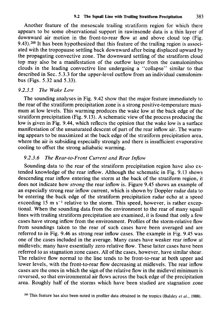
Figure9.43 Analysis emphasizing the structure at and above the top of the squall line with trailing
stratiform precipitation shown in Figs. 9.15, 9.18,
9.31,9.40,9.41,9.44,9.45,9.48,9.53,
and 9.54. This
cross section is taken along the direction of motion of the squall line during the system's later stages of
development. Shown are the streamlines for system-relative flow, potential temperature isotherms
(K), and relative humidity (with respect to ice at temperatures below freezing, values greater than 80%
indicated by shading). Infrared (IR) satellite data were used to determine the height at cloud top.
Airflow and thermal structure are deduced from soundings and assumptions about the infrared
radiative cooling rate at cloud top. Dotted line indicates where vertical air motion (expressed as
w
==
Dp/Dt) is diagnosed to have been zero. (From Johnson et al., 1990. Reprinted with permission from
the American Meteorological Society.)
9.2 The Squall Line with Trailing Stratiform Precipitation
383
Another feature of the mesoscale trailing stratiform region for which there
appears to be some observational support in rawinsonde data is a thin layer of
downward air motion in the front-to-rear flow at and above cloud top (Fig.
9.43).260
It
has been hypothesized that this feature of the trailing region is associ-
ated with the tropopause settling back downward after being displaced upward by
the propagating convective zone. The downward settling of the stratiform cloud
top may also be a manifestation of the outflow layer from the cumulonimbus
clouds in the leading convective line undergoing a
"collapse"
similar to that
described in Sec. 5.3.3 for the upper-level outflow from an individual cumulonim-
bus (Figs. 5.32 and 5.33).
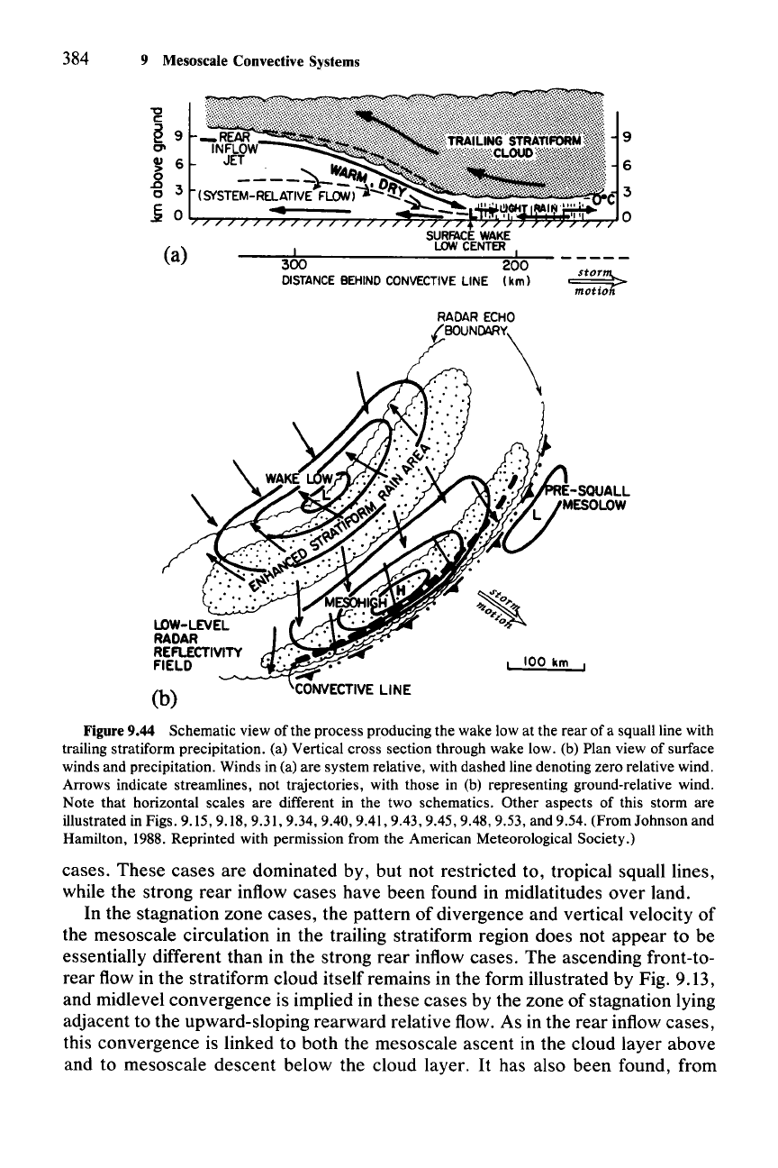
9.2.3.5 The Wake
Low
The sounding analyses in Fig. 9.42 show that the major feature immediately to
the rear of the stratiform precipitation zone is a strong positive-temperature maxi-
mum at low levels. This warming produces the wake low at the back edge of the
stratiform precipitation (Fig. 9.13). A schematic view of the process producing the
low is given in Fig. 9.44, which reflects the opinion that the wake low is a surface
manifestation of the unsaturated descent of part of the rear inflow air. The warm-
ing appears to be maximized at the back edge of the stratiform precipitation area,
where the air is subsiding especially strongly and there is insufficient evaporative
cooling to offset the strong adiabatic warming.
9.2.3.6 The Rear-to-Front Current
and
Rear
Inflow
Sounding data to the rear of the stratiform precipitation region have also ex-
tended knowledge of the rear inflow. Although the schematic in Fig. 9.13 shows
descending rear inflow entering the storm at the back of the stratiform region, it
does not indicate how
strong the rear inflow is. Figure 9.45 shows an example of
an especially strong rear inflow current, which is shown by Doppler radar data to
be entering the back edge of the stratiform precipitation radar echo at a speed
exceeding 15 m
S-I
relative to the storm. This speed, however, is rather excep-
tional. When the sounding data from the environment to the rear of many squall
lines with trailing stratiform precipitation are examined, it is found that only a few
cases have strong inflow from the environment. Profiles of the storm-relative flow
from soundings taken to the rear of such cases have been averaged and are
referred to in Fig. 9.46 as strong rear inflow cases. The example in Fig. 9.45 was
one of the cases included in the average. Many cases have weaker rear inflow at
midlevels; many have essentially zero relative flow. These latter cases have been
referred to as stagnation zone cases. All
ofthe
cases, however, have similar shear.
The relative flow normal to the line tends to be front-to-rear at both upper and
lower levels, with the front-to-rear flow decreasing at midlevels. The rear inflow
cases are the ones in which the sign of the relative flow in the midlevel minimum is
reversed, so that environmental air flows across the back edge of the precipitation
area. Roughly half of the storms which have been studied are stagnation zone
260 This feature has also been noted in pro/Her data obtained in the tropics (Balsley et al., 1988).
384 9 Mesoscale Convective Systems
(a)
(b)
9
6
---:d=------=---
__
::!-:::-
- -
---
~
~
100 km
Figure 9.44 Schematic view of the process producing the wake low at the rear of a squall line with
trailing stratiform precipitation. (a) Vertical cross section through wake low. (b) Plan view of surface
winds and precipitation. Winds in (a) are system relative, with dashed line denoting zero relative wind.
Arrows indicate streamlines, not trajectories, with those in (b) representing ground-relative wind.
Note that horizontal scales are different in the two schematics. Other aspects of this storm are
illustrated in Figs. 9.15, 9.18, 9.31, 9.34, 9.40, 9.41, 9.43, 9.45, 9.48, 9.53, and 9.54. (From Johnson and
Hamilton, 1988. Reprinted with permission from the American Meteorological Society.)
cases. These cases are dominated by, but not restricted to, tropical squall lines,
while the strong rear inflow cases have been found in midlatitudes over land.
In the stagnation zone cases, the pattern of divergence and vertical velocity of
the mesoscale circulation in the trailing stratiform region does not appear to be
essentially different than in the strong rear inflow cases. The ascending front-to-
rear flow in the stratiform cloud itself remains in the form illustrated by Fig. 9.13,
and midlevel convergence is implied in these cases by the zone of stagnation lying
adjacent to the upward-sloping rearward relative flow. As in the rear inflow cases,
this convergence is linked to both the mesoscale ascent in the cloud layer above
and to mesoscale descent below the cloud layer.
It
has also been found, from
9.2 The Squall Line with Trailing Stratiform Precipitation 385
aircraft and radar observations in stagnation zone cases, that rear-to-front flow
develops
internally (i.e., within the trailing rain area itself, storm frontward flow
develops and penetrates forward and into the cold pool of the convective region,
even though no air enters from the environment at the rear of the storm). An
example of this type of storm is the tropical squall line that we have examined
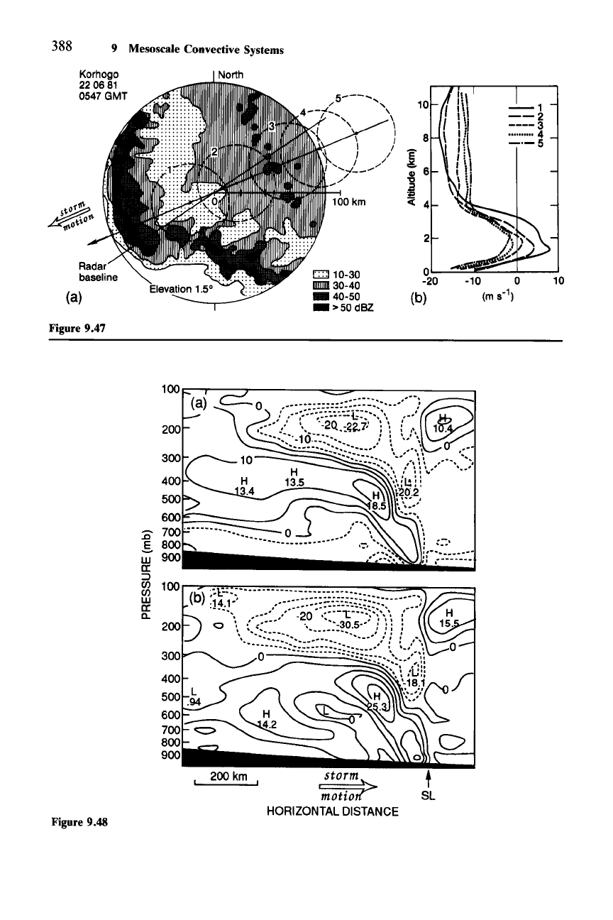
previously in Figs. 9.7, 9.8, and 9.20. In Fig. 9.47 we see that the profile of the
relative wind component normal to the line was strongly frontward just to the rear
of the convective region but decreased to a stagnation value at the back edge of
the stratiform region. Thus, it is clear that the squall line system generates its own
rear-to-front flow in the stratiform region, but that in some cases (especially the
strong rear inflow cases) this frontward flow is enhanced by inflow from the
environment.
The inflow from the environment in a strong rear inflow case has been studied
in the context of a
mesoscale model, which is a limited-area numerical weather
prediction
model-not
a convective cloud model of the type described in Sec. 7.5.
The convective cloud model starts with a single sounding (i.e., uniform and
steady-state large-scale environment) and uses nonhydrostatic equations to pre-
dict the motions internal to a cloud which develops from a specified perturbation
to the otherwise constant environment. The mesoscale model, in contrast, is
concerned with predicting changes in the large-scale environment over an area
much larger than that of the individual convective clouds. The environment may
be initially nonuniform and vary with time, as predicted by the mesoscale model.
The horizontal grid resolution of the model is typically 15-75 km. A variety of
approaches to this type of model have been used. Often, the motions are calcu-
lated with the hydrostatically balanced equations and the convective-scale mo-
tions are parameterized, which means that the net effect of the convective-scale
motions on the larger-scale environment is included in the turbulence terms in the
equation of motion and the thermodynamic equation. These terms are expressed
as functions of the resolvable-scale variables. A typical approach is to assume
that, if the environment becomes conditionally or potentially unstable and suffi-
cient resolvable-scale vertical motion is present to release the instability, the
thermodynamic stratification is overturned by the convection, according to some
prescribed scheme, to restore stability. In the case of a mesoscale convective
cloud system, such as a squall line with a trailing stratiform region, this type of
model resolves the air motions and cloud structure of the stratiform region, while
the motions in the smaller-scale updrafts and downdrafts of the convective region
must be represented by the parameterization scheme.>!
In Fig. 9.48a, we show results of a mesoscale model simulation of a midlatitude
squall line with a trailing stratiform region. This particular simulation used a
nested grid, which was 75 km in resolution except in the vicinity of the convec-
tion, where the grid spacing was reduced to 25 km. The case represented is the
261 See Frank (1983) for reviews of traditional methods of convective parameterization. More
recent ideas are discussed by Betts (1986)and Frank and Cohen (1987). Still more recently, mesoscale
models have replaced the parameterization approach with nested grids that allow explicit nonhydro-
static calculation of the convective-scale processes.
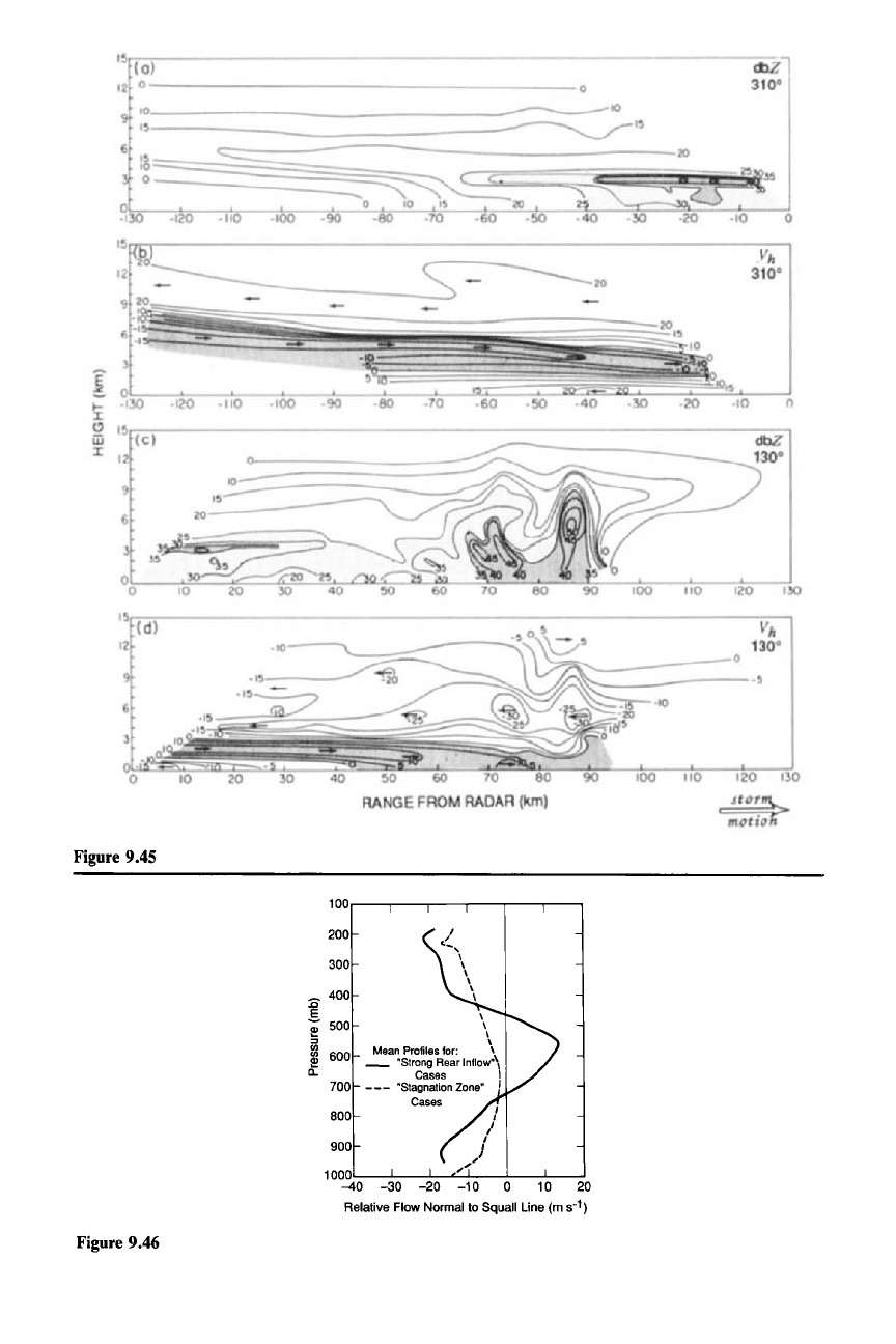
Figure 9.45
Figure 9.46
1oo....---r-----r---r---,.----,----,
200
300
400
!
!'! 500
:::J
~
600
n,
700
800
900
1
00~ILOr---3.L0r---.J..20~O:'-.L1
0----l.0--1:":0---:'20
Relative Flow Normal to Squall Line (m 5-
1)
9.2 The Squall Line with Trailing Stratiform Precipitation 387
one for which the rear inflow was shown in Fig. 9.45. Other aspects of the struc-
ture of the storm have been presented in several other figures (see caption of Fig.
9.48).
It
was a strong rear inflow case. Comparison of Figs. 9.45 and 9.48a shows
that the model represents the general structure quite well, with the rear inflow
jet
entering strongly from the environment to the rear of the stratiform region. From
the horizontal scale of Fig. 9.48 it is evident that the model results cover a region
much broader than the precipitation region shown in Fig. 9.45. Thus, it is evident
that the strong rear inflow extends far out into the environment to the rear of the
storm. Several model runs were made, under different sets of assumptions. These
experiments reveal that, in this case, the inflow from the environment at upper
levels at the back of the system was not pulled in by processes internal to the
storm itself but rather was associated with the baroclinity of the large-scale flow in
which it was embedded. (The squall line lay ahead of a well-defined short-wave
trough in the westerlies.) With the diabatic heating set equal to zero, which is
tantamount to removing all the dynamical effect of the cloud system on the resolv-
able-scale flow, only the upper-level (above 400 mb) part of the rear inflow (i.e.,
that to the rear of the rain area) developed. The mid- to lower-level part of the rear
inflow (i.e., that within the rain area) was absent. This result is illustrated by Fig.
9.48b, where the result with no diabatic heating has been subtracted from the total
result in Fig. 9.48a. All of the rear inflow internal to the storm remains, where the
frontward flow at midlevels descended toward the convective region. The rear
inflow entering from the environment at the rear of the storm is entirely absent
from the difference field. Thus, it appears that the part
ofthe
rear inflow that made
this case one of strong rear inflow (i.e., entering across the back edge of the storm)
was not driven by processes internal to the storm but rather was determined by
the large-scale environment in which the storm was embedded. The large-scale
baroclinity provided deep and favorable rear-to-front flow within the upper half of
the troposphere. This result is a further indication that the rear-to-front flow
within the squall line with a trailing stratiform region is fundamentally the result of
processes internal to the storm, while the factor which determines whether a given
case has strong rear inflow, weak rear inflow, or stagnation at the back edge of the
stratiform region depends on the environment in which the storm occurs.
Figure 9.45 Doppler radar data showing the strength of the rear inflow current entering the back
edge of the stratiform region of the squall-line system illustrated in Figs. 9.15, 9.18, 9.31, 9.34, 9.40,
9.41,9.43,9.44,9.45,9.48,9.53 and 9.54. This particular cross section was shown by a single radar at a
particular moment. Thus, it was not subjected to smoothing as were the composites in Figs. 9.31 and
9.43, and it therefore shows more details of the flow. Panels (a) and (c) depict radar reflectivity (dBZ).
Panels (b) and (d) show system-relative horizontal velocity
V
h
(m
S-I),
respectively, along the 310
0
and
1300
azimuth directions. Positive velocities represent flow away from the radar, while negative
velocities denote flow toward the radar. Arrows indicating flow direction are also shown. Rear inflow
is highlighted by shading in (b) and (d). (From Smull and Houze, 1987. Reproduced with permission
from the American Meteorological Society.)
Figure 9.46 Profiles of the storm-relative flowfrom soundings taken to the rear of squall lines with
trailing stratiform precipitation. (From Smull and Houze, 1987. Reproduced with permission from the
American Meteorological Society.)
388 9 Mesoscale Convective Systems
Korhogo
220681
0547 GMT
(a)
Figure 9.47
Figure 9.48
200
:c
.s
w
a:
~
~
100
w
a:
D..
(a)
200km
c::l10-30
D1IIIII130-40
_40-50
_>50dBZ
,
sto~mn>
motto
HORIZONTAL
DISTANCE
2
O~~~~
-20 10
(b)
