Houze Robert A., Jr. Cloud Dynamics
Подождите немного. Документ загружается.

9.2 The Squall Line with Trailing Stratiform Precipitation 349
16
\
\
\
\ @
.
~
............
I.
~
,I"-STRATIFORM
--\'--..
t -,,--
/x
+
//
-<
20
z
~
8
...J
<[
~
4
:c
16
! CONVECTIVE
g 12
~ W
~
0 2 4 6
5 SEPTEMBER
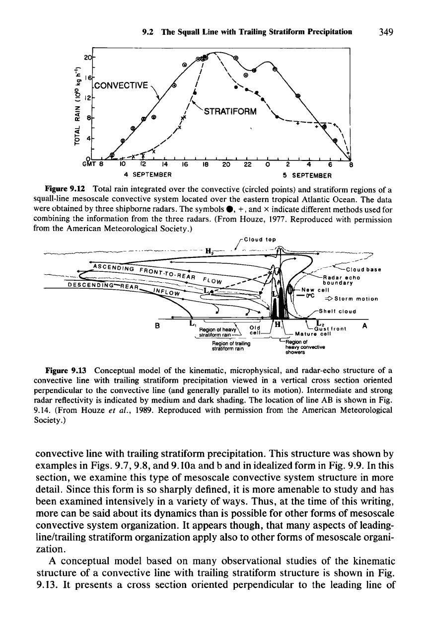
Figure
9.U
Total rain integrated over the convective (circled points) and stratiform regions of a
squall-line mesoscale convective system located over the eastern tropical Atlantic Ocean. The data
were obtained by three shipborne radars. The symbols
e, +, and x indicate different methods used for
combining the information from the three radars. (From Houze, 1977. Reproduced with permission
from the American Meteorological Society.)
B
L '
,
~
Region of heavy
stratiformrain
cell
Mature
cell
,
~
-
~'-c;;:
.
Region of trailing Regionof .
stratiform rain heavy convecllve
showers
A
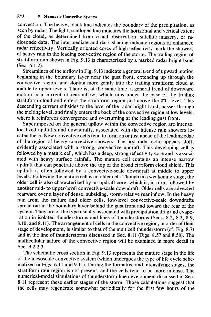
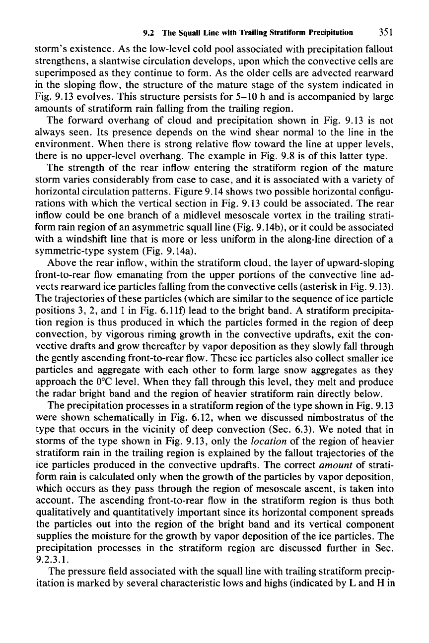
Figure 9.13 Conceptual model of the kinematic, microphysical, and radar-echo structure of a
convective line with trailing stratiform precipitation viewed in a vertical cross section oriented
perpendicular to the convective line (and generally parallel to its motion). Intermediate and strong
radar reflectivity is indicated by medium and dark shading. The location of line AB is shown in Fig.
9.14. (From Houze et al., 1989. Reproduced with permission from the American Meteorological
Society.)
convective line with trailing stratiform precipitation. This structure was shown by
examples in Figs. 9.7,9.8, and 9.lOa and b and in idealized form in Fig. 9.9. In this
section, we examine this type of mesoscale convective system structure in more
detail. Since this forin is so sharply defined, it is more amenable to study and has
been examined intensively in a variety of ways. Thus, at the time of this writing,
more can be said about its dynamics than is possible for other forms of mesoscale
convective system organization.
It
appears though, that many aspects of leading-
line/trailing stratiform organization apply also to other forms of mesoscale organi-
zation.
A conceptual model based on many observational studies of the kinematic
structure of a convective line with trailing stratiform structure is shown in Fig.
9.13.
It
presents a cross section oriented perpendicular to the leading line of
350 9 Mesoscale Convective Systems
convection. The heavy, black line indicates the boundary of the precipitation, as
seen by radar. The light, scalloped line indicates the horizontal and vertical extent
of the cloud, as determined from visual observation, satellite imagery, or ra-
diosonde data. The intermediate and dark shading indicate regions of enhanced
radar reflectivity. Vertically oriented cores of high reflectivity mark the showers
of heavy rain in the leading convective region of the storm. The trailing region of
stratiform rain shown in Fig. 9.13 is characterized by a marked radar bright band
(Sec. 6.1.2).
Streamlines of the airflow in Fig. 9.13 indicate a general trend of upward motion
beginning in the boundary layer near the gust front, extending up through the
convective region, and sloping more gently into the trailing stratiform cloud at
middle to upper levels. There is, at the same time, a general trend of downward
motion in a current of rear inflow, which runs under the base of the trailing
stratiform cloud and enters the stratiform region
just
above the
O°C
level. This
descending current subsides to the level of the radar bright band, passes through
the melting level, and finally enters the back of the convective region at low levels,
where it reinforces convergence and overturning at the leading gust front.
Superimposed on the general upflow within the convective region are intense,
localized updrafts and downdrafts, associated with the intense rain showers lo-
cated there. New convective cells tend to form on or
just
ahead of the leading edge
of the region of heavy convective showers. The first radar echo appears aloft,
evidently associated with a strong, convective updraft. This developing cell is
followed by a mature cell, which has a deep, strong reflectivity core and is associ-
ated with heavy surface rainfall. The mature cell contains an intense narrow
updraft that can penetrate above the top of the broad cirriform cloud shield. This
updraft is often followed by a convective-scale downdraft at middle to upper
levels. Following the mature cell is an older cell. Though in a weakening stage, the
older cell is also characterized by an updraft core, which is, in turn, followed by
another mid- to upper-level convective-scale downdraft. Older cells are advected
rearward over a layer of dense, subsiding, storm-relative rear inflow. In the heavy
rain from the mature and older cells, low-level convective-scale downdrafts
spread out in the boundary layer behind the gust front and toward the rear of the
system. They are of the type usually associated with precipitation drag and evapo-
ration in isolated thunderstorms and lines of thunderstorms (Sees. 8.2, 8.3, 8.9,
8.10, and 8.11). The arrangement of cells in the convective region, in order of their
stage of development, is similar to that of the multicell thunderstorm (cf. Fig. 8.7)
and in the line of thunderstorms discussed in Sec. 8.11 (Figs. 8.57 and 8.58). The
multicellular nature of the convective region will be examined in more detail in
Sec. 9.2.2.3.
The schematic cross section in Fig. 9.13 represents the mature stage in the life
of the mesoscale convective system (which undergoes the type of life cycle sche-
matized in Figs. 6.11 and 9.11). During the formative and intensifying stages, the
stratiform rain region is not present, and the cells tend to be more intense. The
numerical-model simulations of thunderstorm-line development discussed in Sec.
8.11 represent these earlier stages of the storm. Those calculations suggest that
the cells may regenerate somewhat periodically for the first few hours of the
9.2 The Squall Line with Trailing Stratiform Precipitation
351
storm's existence. As the low-level cold pool associated with precipitation fallout
strengthens, a slantwise circulation develops, upon which the convective cells are
superimposed as they continue to form. As the older cells are advected rearward
in the sloping flow, the structure of the mature stage of the system indicated in
Fig. 9.13 evolves. This structure persists for
5-10
h and is accompanied by large
amounts of stratiform rain falling from the trailing region.
The forward overhang of cloud and precipitation shown in Fig. 9.13 is not
always seen. Its presence depends on the wind shear normal to the line in the
environment. When there is strong relative flow toward the line at upper levels,
there is no upper-level overhang. The example in Fig. 9.8 is of this latter type.
The strength of the rear inflow entering the stratiform region of the mature
storm varies considerably from case to case, and it is associated with a variety of
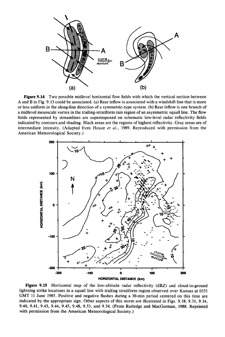
horizontal circulation patterns. Figure 9.14 shows two possible horizontal configu-
rations with which the vertical section in Fig. 9.13 could be associated. The rear
inflow could be one branch of a midlevel mesoscale vortex in the trailing strati-
form rain region of an asymmetric squall line (Fig. 9.14b), or it could be associated
with a windshift line that is more or less uniform in the along-line direction of a
symmetric-type system (Fig. 9.14a).
Above the rear inflow, within the stratiform cloud, the layer of upward-sloping
front-to-rear flow emanating from the upper portions of the convective line ad-
vects rearward ice particles falling from the convective cells (asterisk in Fig. 9.13).
The trajectories of these particles (which are similar to the sequence of ice particle
positions 3, 2, and 1 in Fig. 6.11f) lead to the bright band. A stratiform precipita-
tion region is thus produced in which the particles formed in the region of deep
convection, by vigorous riming growth in the convective updrafts, exit the con-
vective drafts and grow thereafter by vapor deposition as they slowly fall through
the gently ascending front-to-rear flow. These ice particles also collect smaller ice
particles and aggregate with each other to form large snow aggregates as they
approach the
DOC
level. When they fall through this level, they melt and produce
the radar bright band and the region of heavier stratiform rain directly below.
The precipitation processes in a stratiform region of the type shown in Fig. 9.13
were shown schematically in Fig. 6.12, when we discussed nimbostratus of the
type that occurs in the vicinity of deep convection (Sec. 6.3). We noted that in
storms of the type shown in Fig. 9.13, only the location of the region of heavier
stratiform rain in the trailing region is explained by the fallout trajectories of the
ice particles produced in the convective updrafts. The correct amount of strati-
form rain is calculated only when the growth of the particles by vapor deposition,
which occurs as they pass through the region of mesoscale ascent, is taken into
account. The ascending front-to-rear flow in the stratiform region is thus both
qualitatively and quantitatively important since its horizontal component spreads
the particles out into the region of the bright band and its vertical component
supplies the moisture for the growth by vapor deposition of the ice particles. The
precipitation processes in the stratiform region are discussed further in Sec.
9.2.3.1.
The pressure field associated with the squall line with trailing stratiform precip-
itation is marked by several characteristic lows and highs (indicated by
Land
H in
B-~+-
A
B
A
Figure 9.14 Two possible midlevel horizontal flow fields with which the vertical section between
A and B in Fig. 9.13 could be associated. (a) Rear inflow is associated with a windshift line that is more
or less uniform in the along-line direction of a symmetric-type system. (b) Rear inflow is one branch of
a midlevel mesoscale vortex in the trailing-stratiform rain region of an asymmetric squall line. The flow
fields represented by streamlines are superimposed on schematic low-level radar reflectivity fields
indicated by contours and shading. Black areas are the regions of highest reflectivity. Gray areas are of
intermediate intensity. (Adapted from Houze
et al., 1989. Reproduced with permission from the
American Meteorological Society.)
200
+------'--....L..--.&...----L
__
-'-_---l
__
........
__
r
100
E
~
w
~
~
is
0
~
a
II:
0
:I:
·100
N
t
++ +
+
({
...
CI
\
200
100
·100
o
HORIZONTAL
DISTANCE
(km)
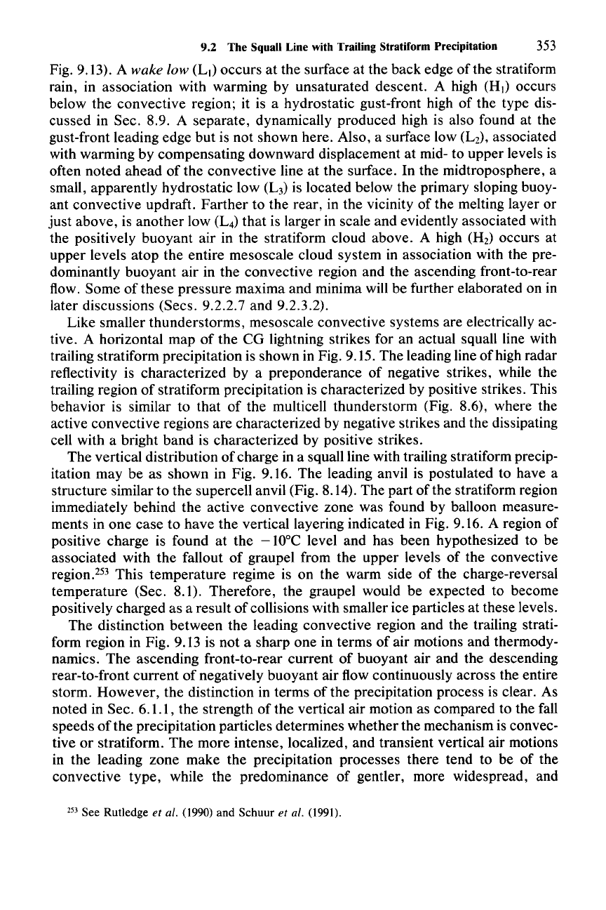
Figure 9.15 Horizontal map of the low-altitude radar reflectivity (dBZ) and cloud-to-ground
lightning strike locations in a squall line with trailing stratiform region observed over Kansas at 0351
GMT
II
June 1985. Positive and negative flashes during a 30-min period centered on this time are
indicated by the appropriate sign. Other aspects of this storm are illustrated in Figs. 9.18,9.31, 9.34,
9.40, 9.41, 9.43, 9.44, 9.45, 9.48, 9.53, and 9.54. (From Rutledge and MacGorman, 1988. Reprinted
with permission from the American Meteorological Society.)
9.2 The Squall Line with Trailing Stratiform Precipitation 353
Fig. 9.13). A wake low (L
I)
occurs at the surface at the back edge
ofthe
stratiform
rain, in association with warming by unsaturated descent. A high (HI) occurs
below the convective region; it is a hydrostatic gust-front high of the type dis-
cussed in Sec. 8.9. A separate, dynamically produced high is also found at the
gust-front leading edge but is not shown here. Also, a surface low (L
z),
associated
with warming by compensating downward displacement at mid- to upper levels is
often noted ahead of the convective line at the surface. In the midtroposphere, a
small, apparently hydrostatic low (L
3
)
is located below the primary sloping buoy-
ant convective updraft. Farther to the rear, in the vicinity of the melting layer or
just above, is another low (L
4
)
that is larger in scale and evidently associated with
the positively buoyant air in the stratiform cloud above. A high (Hz) occurs at
upper levels atop the entire mesoscale cloud system in association with the pre-
dominantly buoyant air in the convective region and the ascending front-to-rear
flow. Some of these pressure maxima and minima will be further elaborated on in
later discussions (Sees. 9.2.2.7 and 9.2.3.2).
Like smaller thunderstorms, mesoscale convective systems are electrically ac-
tive. A horizontal map
of
the CG lightning strikes for an actual squall line with
trailing stratiform precipitation is shown in Fig. 9.15. The leading line of high radar
reflectivity is characterized by a preponderance of negative strikes, while the
trailing region
of
stratiform precipitation is characterized by positive strikes. This
behavior is similar to that of the multicell thunderstorm (Fig. 8.6), where the
active convective regions are characterized by negative strikes and the dissipating
cell with a bright band is characterized by positive strikes.
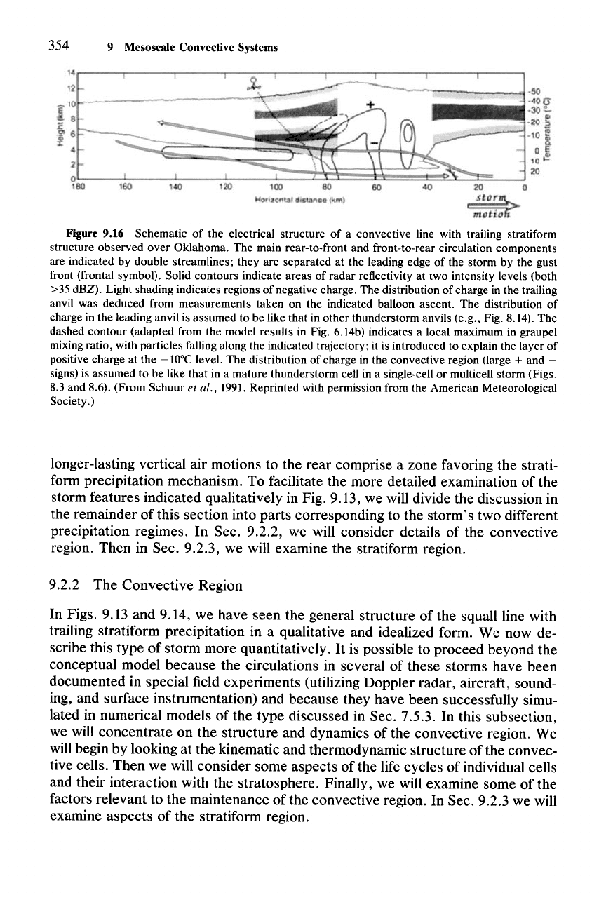
The vertical distribution
of
charge in a squall line with trailing stratiform precip-
itation may be as shown in Fig. 9.16. The leading anvil is postulated to have a
structure similar to the supercell anvil (Fig. 8.14). The part of the stratiform region
immediately behind the active convective zone was found by balloon measure-
ments in one case to have the vertical layering indicated in Fig. 9.16. A region of
positive charge is found at the
-lOoC
level and has been hypothesized to be
associated with the fallout of graupel from the upper levels of the convective
region.F' This temperature regime is on the warm side of the charge-reversal
temperature (Sec. 8.1). Therefore, the graupel would be expected to become
positively charged as a result of collisions with smaller ice particles at these levels.
The distinction between the leading convective region and the trailing strati-
form region in Fig. 9.13 is not a sharp one in terms of air motions and thermody-
namics. The ascending front-to-rear current of buoyant air and the descending
rear-to-front current of negatively buoyant air flow continuously across the entire
storm. However, the distinction in terms of the precipitation process is clear. As
noted in Sec. 6.1.1, the strength of the vertical air motion as compared to the fall
speeds
of
the precipitation particles determines whether the mechanism is convec-
tive or stratiform. The more intense, localized, and transient vertical air motions
in the leading zone make the precipitation processes there tend to be of the
convective type, while the predominance of gentler, more widespread, and
253 See Rutledge et al. (1990) and Schuur et al. (1991).
354 9 Mesoscale Convective Systems
Figure 9.16 Schematic of the electrical structure of a convective line with trailing stratiform
structure observed over Oklahoma. The main rear-to-front and front-to-rear circulation components
are indicated by double streamlines; they are separated at the leading edge of the storm by the gust
front (frontal symbol). Solid contours indicate areas of radar reflectivity at two intensity levels (both
>35 dBZ). Light shading indicates regions of negative charge. The distribution of charge in the trailing
anvil was deduced from measurements taken on the indicated balloon ascent. The distribution of
charge in the leading anvil is assumed to be like that in other thunderstorm anvils (e.g., Fig. 8.14). The
dashed contour (adapted from the model results in Fig. 6.14b) indicates a local maximum in graupel
mixing ratio, with particles falling along the indicated trajectory; it is introduced to explain the layer of
positive charge at the
-10°C
level. The distribution of charge in the convective region (large + and -
signs) is assumed to be like that in a mature thunderstorm cell in a single-cell or multicell storm (Figs.
8.3 and 8.6). (From Schuur
et al., 1991. Reprinted with permission from the American Meteorological
Society.)
longer-lasting vertical air motions to the rear comprise a zone favoring the strati-
form precipitation mechanism. To facilitate the more detailed examination of the
storm features indicated qualitatively in Fig. 9.13, we will divide the discussion in
the remainder of this section into parts corresponding to the storm's two different
precipitation regimes. In Sec. 9.2.2, we will consider details of the convective
region. Then in Sec. 9.2.3, we will examine the stratiform region.
9.2.2 The Convective Region
In Figs. 9.13 and 9.14, we have seen the general structure of the squall line with
trailing stratiform precipitation in a qualitative and idealized form. We now de-
scribe this type of storm more quantitatively.
It
is possible to proceed beyond the
conceptual model because the circulations in several of these storms have been
documented in special field experiments (utilizing Doppler radar, aircraft, sound-
ing, and surface instrumentation) and because they have been successfully simu-
lated in numerical models of the type discussed in Sec. 7.5.3. In this subsection,
we will concentrate on the structure and dynamics of the convective region. We
will begin by looking at the kinematic and thermodynamic structure of the convec-
tive cells. Then we will consider some aspects of the life cycles of individual cells
and their interaction with the stratosphere. Finally, we will examine some of the
factors relevant to the maintenance of the convective region. In Sec. 9.2.3 we will
examine aspects of the stratiform region.
9.2 The Squall Line with Trailing Strlltiform Precipitation 355
9.2.2.1 Observed Airflow
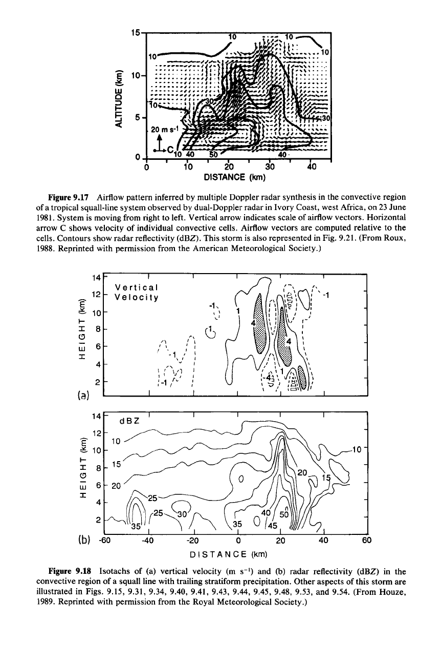
A typical example of the airflow pattern inferred by multiple Doppler radar
synthesis (Sec. 4.4.6) in the convective region of a mesoscale convective system is
shown in Fig. 9.17. The main current of slantwise upward flow toward the rear of
the system is evident. Superimposed on this upward flow are sharp bumps corre-
sponding to each convective cell within this cross section through the convective
region. Each bump in the flow is seen to be associated with a reflectivity maxi-
mum, with each successive peak reaching a higher altitude in a stair-step fashion.
The second stair step corresponds to the strongest reflectivity cell. Another exam-
ple, for which isotachs of vertical velocity are shown, is in Fig. 9.18. Again the
updraft peaks are found at successively higher altitudes. In this case, strong
downdraft cells are also seen in the convective region. There are two types of
these downdrafts. Low-level downdrafts are associated with the heavy rain
showers. These evidently are the precipitation-driven downdrafts typically associ-
ated with the rainshafts and hailshafts of thunderstorms (Sees. 8.2, 8.3, 8.9, and
8.10). They feed the pool of cold air that accumulates below the convective region
and whose leading edge is the gust front forming the leading edge of the mesoscale
system (Fig. 9.13). In addition to the low-level downdrafts are upper-level down-
drafts that tend to occur on either side of the updraft cores. They are apparently
forced by the downward pressure perturbation force found on either side of a
buoyant element (Fig. 7.1).
It
can be shown by application of the appropriate
boundary condition to (7.8) that this downward force becomes intensified when
the buoyant element approaches a rigid upper boundary.
9.2.2.2 Thermodynamic Structure
The thermodynamic structure of mesoscale convective systems is much more
difficult to document than the airflow, which can be derived from Doppler radar
observation. Some data on the thermodynamic structure have been obtained dur-
ing aircraft missions. The most significant thermodynamic feature of the squall
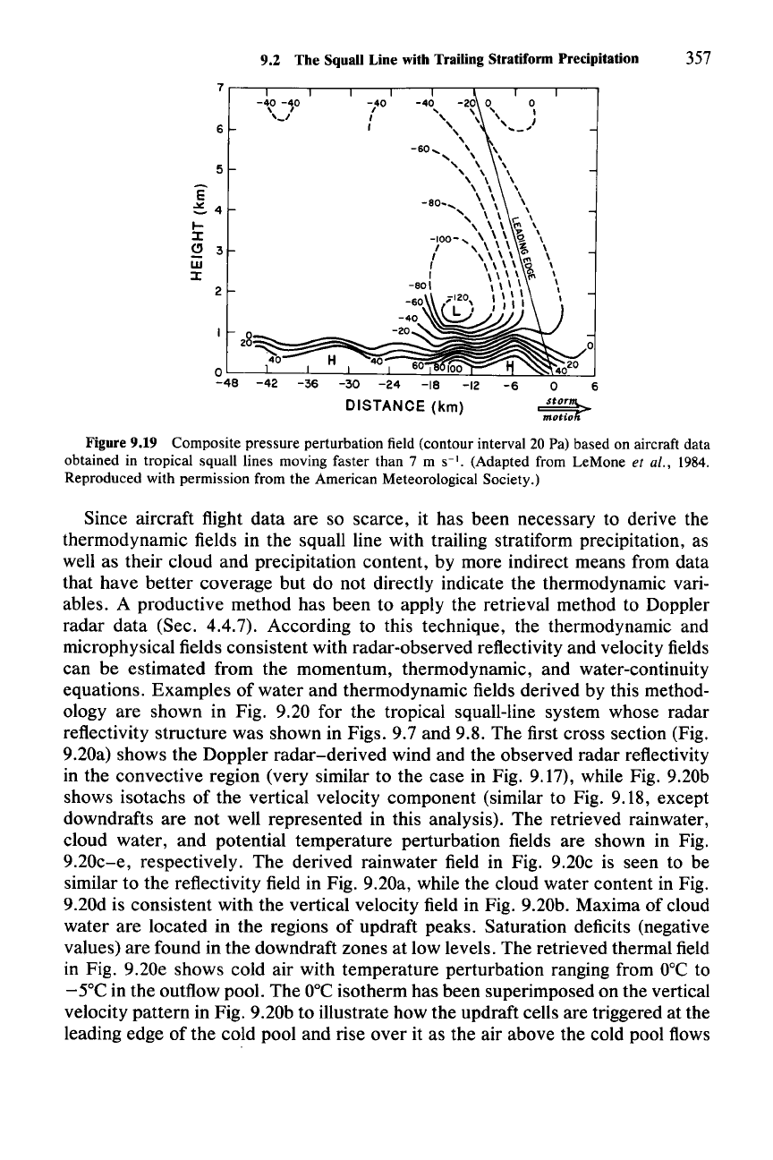
line revealed by aircraft data is the existence of a small, low-pressure center,
about 10 km wide, located under the upward- and rearward-sloping channel of
buoyant air in the convective region in Fig. 9.19. The low-pressure area was found
by averaging measurements from several flights through squall lines.
It
is appar-
ently centered beneath the strongest cell in the convective region. Thus, it is
associated with the buoyancy component of the perturbation pressure
(p~),
which
is required to be a minimum at the base of a buoyant column as illustrated by the
lines of force in Fig. 7.1. The aircraft-measured pressure perturbation minimum is
roughly in hydrostatic balance with the buoyancy perturbation, also measured by
aircraft in the column of air above. From the aircraft data alone, it is not apparent
whether there is a dynamic contribution to this pressure perturbation minimum in
addition to the buoyancy contribution. We will see below that model simulations
indicate that the pressure perturbation minimum is largely hydrostatic but that in
strong squall-line circulations there is also a significant contribution from the
dynamic pressure perturbation
(pi» associated with the characteristic vortex in
the gust-front head [Sec. 8.9, Eq. (8.44), Fig. 8.42].
15-r-------..,.."..-----..,..,.......--
....
40
40·
20 30
DISTANCE
(kin)
20ms·
1
o
lc10'~'40~~$2
o 10
5
~
10
w
o
~
5
-e
Figure 9.17 Airflow pattern inferred by multiple Doppler radar synthesis in the convective region
of a tropical squall-line system observed by dual-Doppler radar in Ivory Coast, west Africa, on
23 June
1981. System is moving from right to left. Vertical arrow indicates scale of airflow vectors. Horizontal
arrow C shows velocity of individual convective cells. Airflow vectors are computed relative to the
cells. Contours show radar reflectivity (dBZ). This storm is also represented in Fig.
9.21. (From Roux,
1988. Reprinted with permission from the American Meteorological Society.)
40 60
10
14
Vertical
12
Velocity
E
-1,
e.
10
' \
I-
,-'
I
8
6
~
r,
6
/\
I,
W
I,
I I
I
" ,
I
-1
'}
I
4
"
I
\ f
\/1
I
I'
J I
I
2
:-1/"
I
I
(a)
14
dBZ
12
10~~
E
e.
10
I-
15/
I
8
o
w
6
20
I
f2S
4
iB1r25~/,\
2
(b) -60
-40 -20
0
DIS
TAN
C E (krn)
Figure 9.18 Isotachs of (a) vertical velocity (m
S-l)
and (b) radar reflectivity (dBZ) in the
convective region of a squall line with trailing stratiform precipitation. Other aspects of this storm are
illustrated in Figs.
9.15, 9.31, 9.34, 9.40, 9.41, 9.43, 9.44, 9.45, 9.48, 9.53, and 9.54. (From Houze,
1989. Reprinted with permission from the Royal Meteorological Society.)
9.2 The Squall Line with Trailing Stratiform Precipitation 357
6
~
~
-60
.....
-40
,
I
I
H
40
-40 -40
\ ,
'_I
O'-:--l.---.Jl.---.Jl.----.J_.::.J~~=___.:..I__....:~~:._...J
-48
-42
-36
-30
-24
-18
DISTANCE
(km)
2
5
6
E
~4
l-
I
Q 3
w
I
Figure 9.19 Composite pressure perturbation field (contour interval 20 Pal based on aircraft data
obtained in tropical squall lines moving faster than 7 m
S-I.
(Adapted from LeMone et al., 1984.
Reproduced with permission from the American Meteorological Society.)
Since aircraft flight data are so scarce, it has been necessary to derive the
thermodynamic fields in the squall line with trailing stratiform precipitation, as
well as their cloud and precipitation content, by more indirect means from data
that have better coverage but do not directly indicate the thermodynamic vari-
ables. A productive method has been to apply the retrieval method to Doppler
radar data (Sec. 4.4.7). According to this technique, the thermodynamic and
microphysical fields consistent with radar-observed reflectivity and velocity fields
can be estimated from the momentum, thermodynamic, and water-continuity
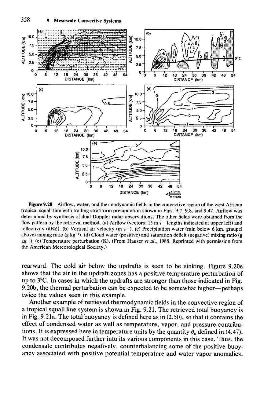
equations. Examples of water and thermodynamic fields derived by this method-
ology are shown in Fig. 9.20 for the tropical squall-line system whose radar
reflectivity structure was shown in Figs. 9.7 and 9.8. The first cross section (Fig.
9.20a) shows the Doppler radar-derived wind and the observed radar reflectivity
in the convective region (very similar to the case in Fig. 9.17), while Fig. 9.20b
shows isotachs of the vertical velocity component (similar to Fig. 9.18, except
downdrafts are not well represented in this analysis). The retrieved rainwater,
cloud water, and potential temperature perturbation fields are shown in Fig.
9.20c-e, respectively. The derived rainwater field in Fig. 9.20c is seen to be
similar to the reflectivity field in Fig. 9.20a, while the cloud water content in Fig.
9.20d is consistent with the vertical velocity field in Fig. 9.20b. Maxima of cloud
water are located in the regions of updraft peaks. Saturation deficits (negative
values) are found in the downdraft zones at low levels. The retrieved thermal field
in Fig. 9.20e shows cold air with temperature perturbation ranging from
O°C
to
- 5°C in the outflow pool. The
O°C
isotherm has been superimposed on the vertical
velocity pattern in Fig. 9.20b to illustrate how the updraft cells are triggered at the
leading edge of the cold pool and rise over it as the air above the cold pool flows
358 9 Mesoscale Convective Systems
6 12 18 24 30 36 42 48 54
DISTANCE (kin)
5.0
2.5
0+-¥~.....c;;..c:..--.--
.......
-r'C::;===1
o 6 12 18 24 30 36 42 48 54
DISTANCE (kin)
~
motlOn
10.0
:[
7.5
w
~
5.0
~
2.5
-e
_
_
:[10.0
7.5
(d) ( 1 3
<;;_
!1:::
~Z~
~
50
~)~~ZJ
0=
J?
J
~25~~
c.QJ_
+----."'-'-.!fL---f::::"-..----T---''r--.--,--1
0
-l=-::.Lr-1C..
f
l'"
:"-
":::
'-
::;==r=-
1.;
l
=;==r===;===;r==::::J
54 0 6 12 18 24 30 36 42 48 54
DISTANCE (kin)
~
10.0
!
7.5
w
0
E
5.0
~
2.5
-c
6
(e)
:[100
W 7.5
0
E
5.0
~
2.5
0
0 6 12
Figure 9.20 Airflow, water, and thermodynamic fields in the convective region of the west African
tropical squall line with trailing stratiform precipitation shown in Figs. 9.7, 9.8, and 9.47. Airflow was
determined by synthesis of dual-Doppler radar observations. The other fields were obtained from the
flow pattern by the retrieval method. (a) Airflow (vectors; 15 m S-I lengths indicated at upper left) and
reflectivity (dBZ). (b) Vertical air velocity (m S-l). (c) Precipitation water (rain below 6 km, graupel
above) mixing ratio (g kg-I). (d) Cloud water (positive) and saturation deficit (negative) mixing ratio (g
kg:"). (e) Temperature perturbation (K). (From Hauser
et al., 1988. Reprinted with permission from
the American Meteorological Society.)
rearward. The cold air below the updrafts is seen to be sinking. Figure 9.20e
shows that the air in the updraft zones has a positive temperature perturbation of
up to 3°C. In cases in which the updrafts are stronger than those indicated in Fig.
9.20b, the thermal perturbation can be expected to be somewhat
higher-perhaps
twice the values seen in this example.
Another example of retrieved thermodynamic fields in the convective region of
a tropical squall line system is shown in Fig. 9.21. The retrieved total buoyancy is
in Fig. 9.21a. The total buoyancy is defined here as in (2.50), so that it contains the
effect of condensed water as well as temperature, vapor, and pressure contribu-
tions.
It
is expressed here in temperature units by the quantity ()a defined in (4.47).
It
was not decomposed further into its various components in this case. Thus, the
condensate contributes negatively, counterbalancing some of the positive buoy-
ancy associated with positive potential temperature and water vapor anomalies.
