Houze Robert A., Jr. Cloud Dynamics
Подождите немного. Документ загружается.

\
\
\
\
/
\
\
\
I
I
/
/
/
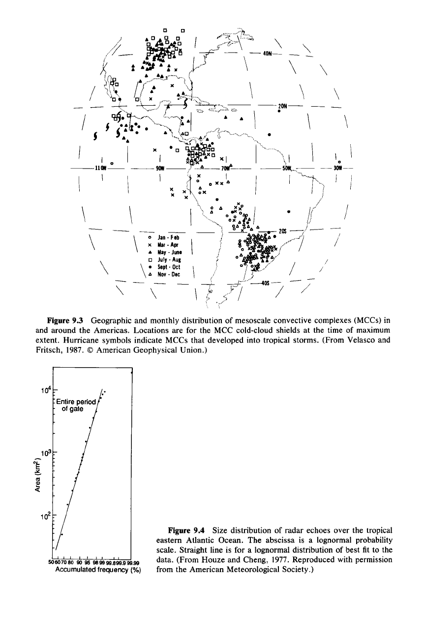
Figure 9.3 Geographic and monthly distribution of mesoscale convective complexes (MCCs) in
and around the Americas. Locations are for the MCC cold-cloud shields at the time of maximum
extent. Hurricane symbols indicate MCCs that developed into tropical storms. (From Velasco and
Fritsch, 1987. © American Geophysical Union.)
506070809095
989999.899.999.99
Accumulatedfrequency (%)
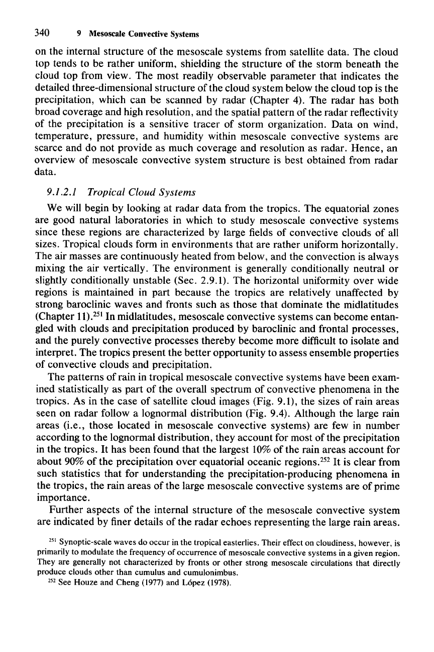
Figure 9.4 Size distribution of radar echoes over the tropical
eastern Atlantic Ocean. The abscissa is a lognormal probability
scale. Straight line is for a lognormal distribution of best fit to the
data. (From Houze and Cheng, 1977. Reproduced with permission
from the American Meteorological Society.)
340 9 Mesoscale Convective Systems
on the internal structure of the mesoscale systems from satellite data. The cloud
top tends to be rather uniform, shielding the structure of the storm beneath the
cloud top from view. The most readily observable parameter that indicates the
detailed three-dimensional structure of the cloud system below the cloud top is the
precipitation, which can be scanned by radar (Chapter 4). The radar has both
broad coverage and high resolution, and the spatial pattern
ofthe
radar reflectivity
of the precipitation is a sensitive tracer of storm organization. Data on wind,
temperature, pressure, and humidity within mesoscale convective systems are
scarce and do not provide as much coverage and resolution as radar. Hence, an
overview of mesoscale convective system structure is best obtained from radar
data.
9.1.2.1 Tropical Cloud
Systems
We will begin by looking at radar data from the tropics. The equatorial zones
are good natural laboratories in which to study mesoscale convective systems
since these regions are characterized by large fields of convective clouds of all
sizes. Tropical clouds form in environments that are rather uniform horizontally.
The air masses are continuously heated from below, and the convection is always
mixing the air vertically. The environment is generally conditionally neutral or
slightly conditionally unstable (Sec. 2.9.1). The horizontal uniformity over wide
regions is maintained in part because the tropics are relatively unaffected by
strong baroclinic waves and fronts such as those that dominate the midlatitudes
(Chapter
11).251
In midlatitudes, mesoscale convective systems can become entan-
gled with clouds and precipitation produced by baroclinic and frontal processes,
and the purely convective processes thereby become more difficult to isolate and
interpret. The tropics present the better opportunity to assess ensemble properties
of convective clouds and precipitation.
The patterns of rain in tropical mesoscale convective systems have been exam-
ined statistically as part of the overall spectrum of convective phenomena in the
tropics. As in the case of satellite cloud images (Fig. 9.1), the sizes of rain areas
seen on radar follow a lognormal distribution (Fig. 9.4). Although the large rain
areas (i.e., those located in mesoscale convective systems) are few in number
according to the lognormal distribution, they account for most of the precipitation
in the tropics.
It
has been found that the largest 10% of the rain areas account for
about 90% of the precipitation over equatorial oceanic
regions.P?
It
is clear from
such statistics that for understanding the precipitation-producing phenomena in
the tropics, the rain areas of the large mesoscale convective systems are of prime
importance.
Further aspects of the internal structure of the mesoscale convective system
are indicated by finer details of the radar echoes representing the large rain areas.
251 Synoptic-scale waves do occur in the tropical easterlies. Their effect on cloudiness, however, is
primarily to modulate the frequency of occurrence of mesoscale convective systems in a given region.
They are generally not characterized by fronts or other strong mesoscale circulations that directly
produce clouds other than cumulus and cumulonimbus.
252 See Houze and Cheng (1977) and Lopez (1978).
9.1 General Characteristics of the Cloud and Precipitation Patterns
341
The locations of strong convective-scale air motions within the rain areas are
indicated in horizontal maps of radar reflectivity by intense spots of reflectivity
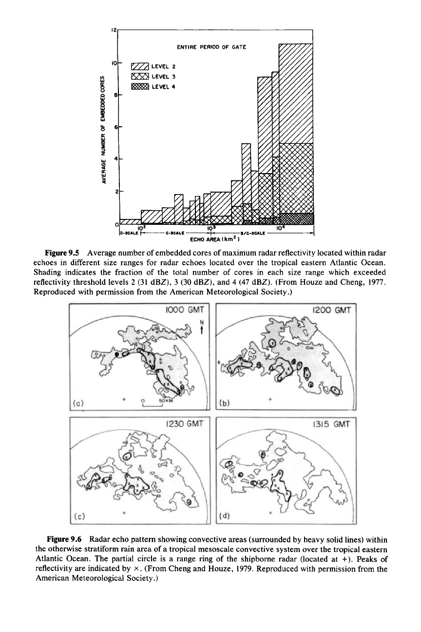
within the broader echo pattern. When the number of convective echo cores were
counted within the rain areas of a large number of tropical mesoscale convective
systems, it was found that, on average, only about 10 convective echo cores were
embedded in echoes exceeding 10,000 km
2
in area (last column on the right in Fig.
9.5). The convective echo cores counted were typically 100km
2
in area. Thus, it is
concluded that only about 10%
of
the rain area in a mesoscale convective system
is covered by convective rain showers. The remainder of the area is covered by
stratiform rain (of the type discussed in Chapter 6).
The spatial pattern of convective cores in relation to the surrounding stratiform
portion of the rain area in a mesoscale convective system varies from case to case
and is a sensitive indicator of the storm organization. The example in Fig. 9.6
shows the pattern of convective areas within the otherwise stratiform rain area of
a tropical mesoscale convective system. The centers of the convective showers
are indicated by an X, and the region of rain thought to be directly associated with
the convective cores is enclosed by a line surrounding the core centers. During the
75-min period shown, the pattern of convective cores varied. The distribution of
cells was somewhat random but displayed a preference for occurring along a
rough line on the southern side of the rain area. The pattern of cells can be even
more random than in this example, embedded chaotically throughout the strati-
form echo region. However, more often than not, they show a tendency to occur
in lines or bands. Sometimes the band of convection becomes very sharply de-
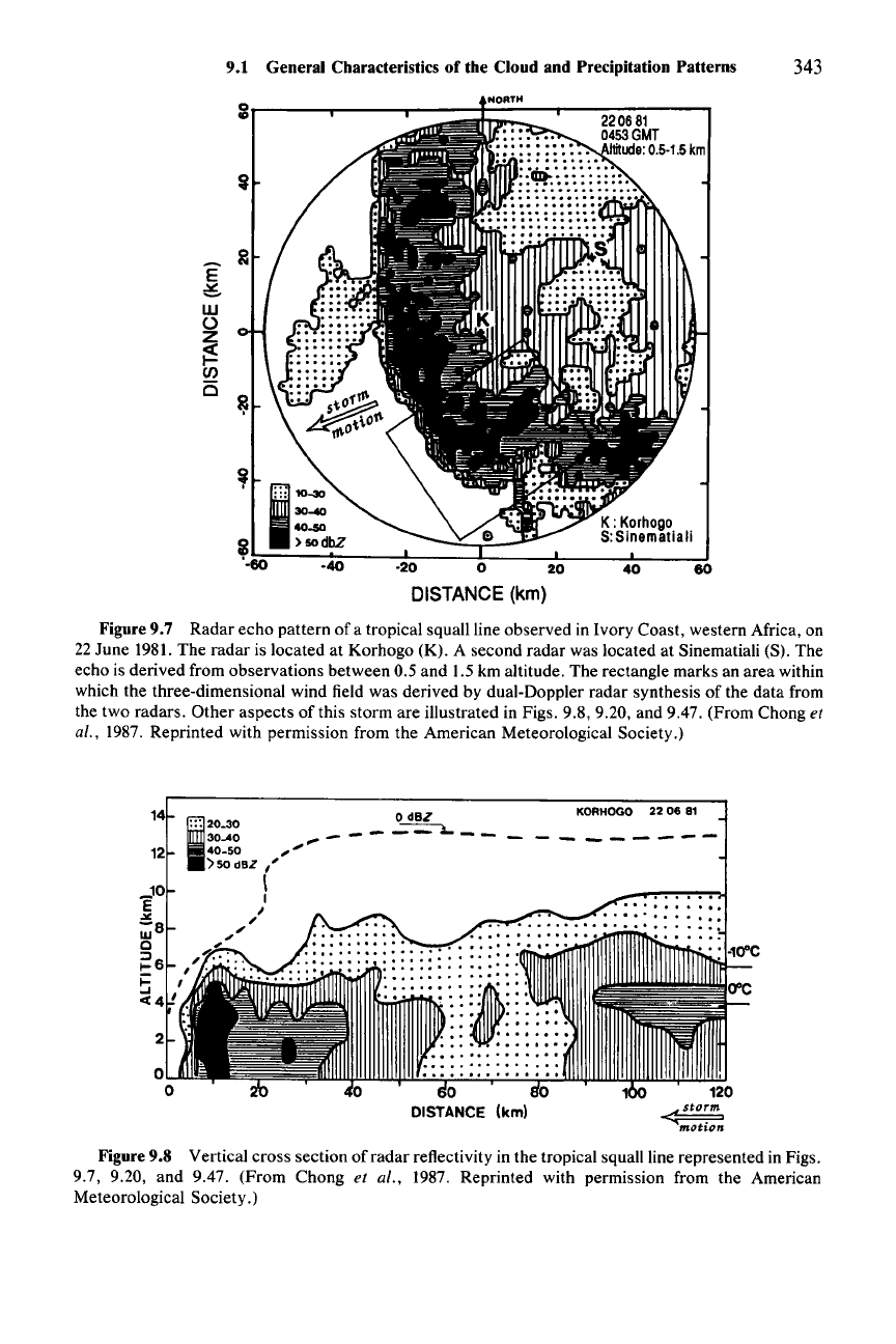
fined, as shown in the example in Fig. 9.7. In this type of case, referred to as a
tropical squall line, the band is often arc shaped and moving rapidly (l0-15 m
S-I).
The stratiform precipitation in this case trails behind the intense convective line.
The radar echoes in the convective and stratiform portions of a rain area in a
mesoscale convective system are clearly distinguished in vertical cross sections
through the radar reflectivity pattern.
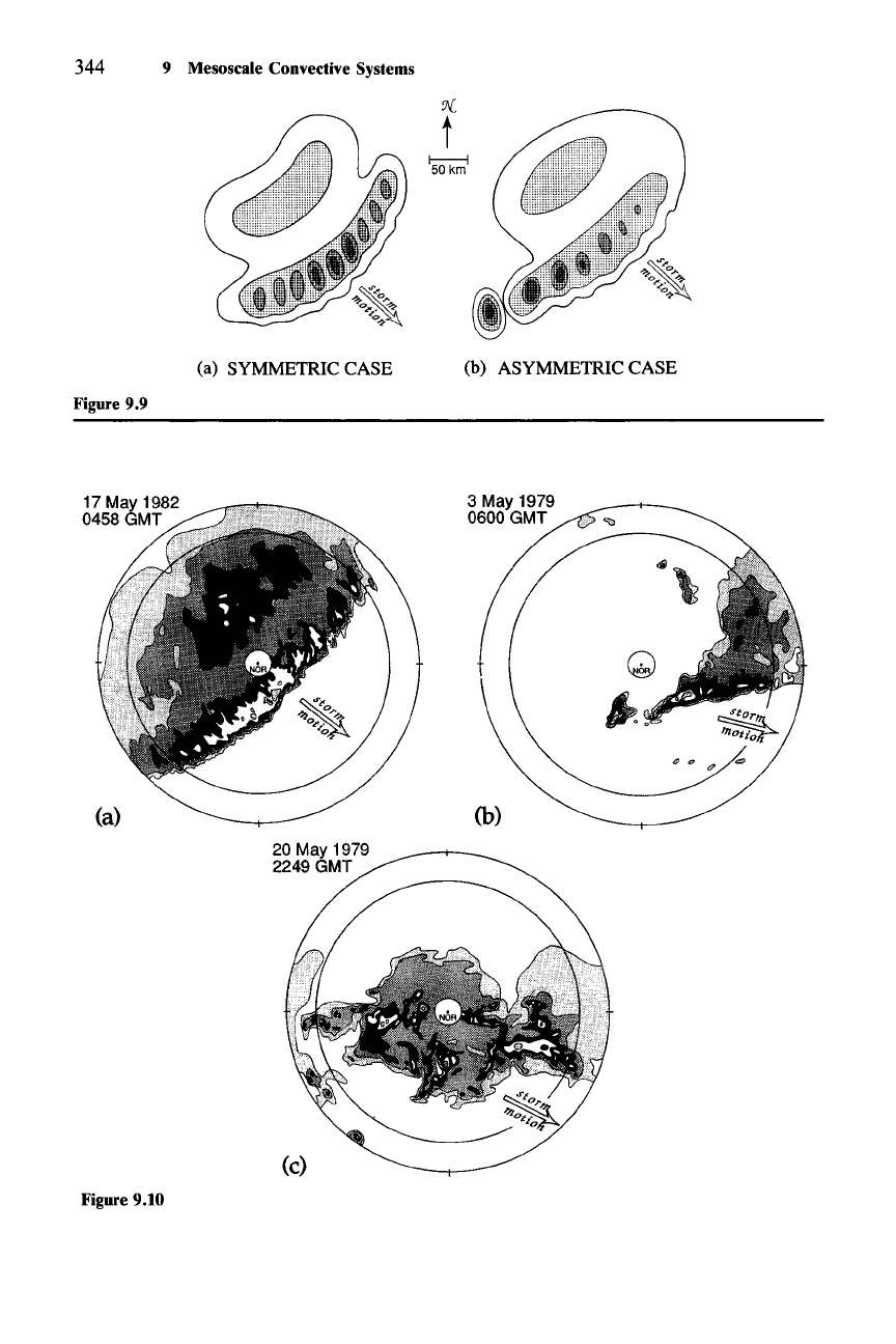
For
example, Fig. 9.8 shows a vertical cross
section through the tropical squall-line rain area of Fig. 9.7. A convective cell at
the leading edge of the rain area is apparent as the intense vertical core of reflec-
tivity in the left-hand side of the picture.
It
stands in sharp contrast to the struc-
ture of the trailing stratiform echo (right-hand portion of Fig. 9.8), which is charac-
terized by a horizontally oriented bright band in the melting layer
just
below the
O°C
isotherm (Sec. 6.1.2). In this type of squall line, the upper portion of the radar
echo of the convective line slopes back toward the trailing stratiform region, as
seen in the region between 0 and 40 km on the horizontal scale in Fig. 9.8. In
nonsquall rain areas, such as in Fig. 9.6, the radar echoes of the convective cells
tend to be more upright at upper levels.
9.1.2.2 Midlatitude Convective Systems
The precipitation areas of midlatitude mesoscale convective systems are simi-
lar to those in the tropics in that the rain areas are of similar size and, at their
mature stage of development, consist of a group or line of convective showers
embedded in or adjoining a large region of stratiform precipitation. A common
12,------------------------,
10'
I a/C·SCALE
----
ECHOAREA(km
2
j
ENTIRE
PERIOD
OF GATE
E22Ll
LEVEL 2
~
LEVEL 3
~
LEVEL 4
2
o
6
4
8
10
Figure 9.5 Average number of embedded cores of maximum radar reflectivity located within radar
echoes in different size ranges for radar echoes located over the tropical eastern Atlantic Ocean.
Shading indicates the fraction of the total number of cores in each size range which exceeded
reflectivity threshold levels 2 (31 dBZ), 3 (30 dBZ), and 4 (47 dBZ). (From Houze and Cheng, 1977.
Reproduced with permission from the American Meteorological Society.)
Figure
9.6
Radar echo pattern showing convective areas (surrounded by heavy solid lines) within
the otherwise stratiform rain area of a tropical mesoscale convective system over the tropical eastern
Atlantic Ocean. The partial circle is a range ring of the shipborne radar (located at
+).
Peaks of
reflectivity are indicated by
x.
(From Cheng and Houze, 1979. Reproduced with permission from the
American Meteorological Society.)
9.1 General Characteristics of the Cloud and Precipitation Patterns 343
60
40
20
o
-20
E
~
w
o
z
~
(J)
15
~r----r---....,----f"';"'---r--::-:::-:-:---,
DISTANCE
(km)
Figure 9.7 Radar echo pattern of a tropical squall line observed in Ivory Coast, western Africa, on
22 June 1981. The radar is located at Korhogo (K). A second radar was located at Sinematiali (S). The
echo is derived from observations between 0.5 and 1.5 km altitude. The rectangle marks an area within
which the three-dimensional wind field was derived by dual-Doppler radar synthesis of the data from
the two radars.
Other
aspects of this storm are illustrated in Figs. 9.8, 9.20, and 9.47. (From Chong et
al., 1987. Reprinted with permission from the American Meteorological Society.)
KORHOGO 22 06 B1
-------
~.~-_
.. ::: .
o
DISTANCE (km)
14
I'::
20_30 0
dBZ
30-40
".-----~--
12 40_50
.>
)50
dBZ "
I
_10 I
E I
.>0:
"
;8
",'"
o ,.
~
,,"'
..,
I-
6,
';:.
6 '
ct4'
Figure 9.8 Vertical cross section of radar reflectivity in the tropical squall line represented in Figs.
9.7, 9.20, and 9.47. (From Chong et al., 1987. Reprinted with permission from the American
Meteorological Society.)
'J{
t
344 9 Mesoscale Convective Systems
(a) SYMMETRIC CASE
Figure 9.9
(b) ASYMMETRIC CASE
(a)
20 May 1979
2249
GMT
3 May 1979
0600
GMT
(b)
(c)
Figure 9.10
9.1 General Characteristics of the Cloud and Precipitation Patterns 345
pattern is again the leading line of convective showers trailed by a region of
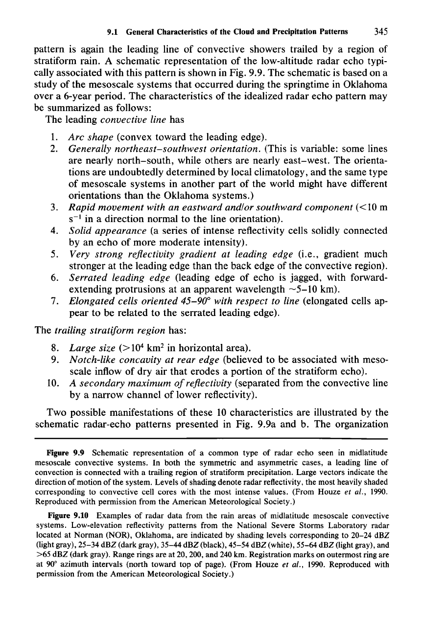
stratiform rain. A schematic representation of the low-altitude radar echo typi-
cally associated with this pattern is shown in Fig. 9.9. The schematic is based on a
study of the mesoscale systems that occurred during the springtime in Oklahoma
over a 6-year period. The characteristics of the idealized radar echo pattern may
be summarized as follows:
The leading convective line has
1.
Arc
shape (convex toward the leading edge).
2. Generally northeast-southwest orientation. (This is variable: some lines
are nearly north-south, while others are nearly east-west. The orienta-
tions are undoubtedly determined by local climatology, and the same type
of mesoscale systems in another part of the world might have different
orientations than the Oklahoma systems.)
3. Rapid
movement
with an eastward and/or southward component
«10
m
S-I
in a direction normal to the line orientation).
4. Solid appearance (a series of intense reflectivity cells solidly connected
by an echo of more moderate intensity).
5. Very strong reflectivity gradient at leading edge (i.e., gradient much
stronger at the leading edge than the back edge of the convective region).
6. Serrated leading edge (leading edge of echo is jagged, with forward-
extending protrusions at an apparent wavelength
~5-10
km).
7. Elongated cells oriented 45-90° with respect to line (elongated cells ap-
pear to be related to the serrated leading edge).
The trailing stratiform region has:
8. Large size
(>
10
4
km
2
in horizontal area).
9. Notch-like concavity at rear edge (believed to be associated with meso-
scale inflow of dry air that erodes a portion of the stratiform echo).
10. A secondary maximum
of
reflectivity (separated from the convective line
by a narrow channel of lower reflectivity).
Two possible manifestations of these 10 characteristics are illustrated by the
schematic radar-echo patterns presented in Fig. 9.9a and b. The organization
Figure 9.9 Schematic representation of a common type of radar echo seen in midlatitude
mesoscale convective systems. In both the symmetric and asymmetric cases, a leading line of
convection is connected with a trailing region of stratiform precipitation. Large vectors indicate the
direction of motion of the system. Levels of shading denote radar reflectivity, the most heavily shaded
corresponding to convective cell cores with the most intense values. (From Houze et al.,
1990.
Reproduced with permission from the American Meteorological Society.)
Figure 9.10 Examples of radar data from the rain areas of midlatitude mesoscale convective
systems. Low-elevation reflectivity patterns from the National Severe Storms Laboratory radar
located at Norman (NOR), Oklahoma, are indicated by shading levels corresponding to 20-24 dBZ
(light gray), 25-34 dBZ (dark gray), 35-44 dBZ (black), 45-54 dBZ (white), 55-64 dBZ (light gray), and
>65 dBZ (dark gray). Range rings are at 20, 200, and 240 km. Registration marks on outermost ring are
at
90
0
azimuth intervals (north toward top of page). (From Houze et al., 1990. Reproduced with
permission from the American Meteorological Society.)
346 9 Mesoscale Convective Systems
shown in Fig. 9.9a is referred to as symmetric, while that in Fig. 9.9b is referred to
as
asymmetric.
In the symmetric case, the convective line shows
• no preference for the
most
intense cells to be
found
at any particular loca-
tion along the leading edge
of
the line. New cell growth apparently occurs
all along the leading edge of the line,
while the stratiform region has its
• centroid located directly behind the center
of
the convective line.
In the asymmetric case, the convective line is
• stronger on its southern, southwestern, or western end. That is, younger,
newly formed, and more intense cells are located toward one end
ofthe
line,
while weaker, dying cells on the verge of becoming stratiform are found
toward the other end of the line,
and the centroid of the stratiform region is
• biased toward the north, northeast, or east end
of
the line, rather than
centered behind the line.
Actual examples of the symmetric and asymmetric type of rain area organization
are shown in Fig. 9. lOa and b. About two-thirds of the rain areas associated with
the investigated mesoscale convective systems in Oklahoma have been found to
exhibit, at least to some degree, either the symmetric or asymmetric structure at
their mature stage of development. In addition to echo patterns that closely or
partially resemble these prototypes, there exist mesoscale convective systems
whose rain areas bear no resemblance to these prototypes. In these systems, the
convective cells are distributed in a much more chaotic pattern in relation to the
stratiform precipitation. An example of a rain area with this more chaotic struc-
ture is shown in Fig. 9.lOc.
It
is somewhat reminiscent of the tropical convective
system illustrated in Fig. 9.6.
9.1.3 Life Cycle of a Precipitation Area
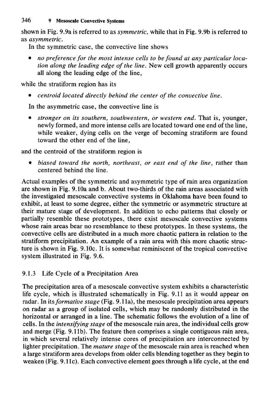
The precipitation area of a mesoscale convective system exhibits a characteristic
life cycle, which is illustrated schematically in Fig. 9.11 as it would appear on
radar. In its
formative stage (Fig. 9.11a), the mesoscale precipitation area appears
on radar as a group of isolated cells, which may be randomly distributed in the
horizontal or arranged in a line. The schematic follows the evolution of a line of
cells. In the
intensifying stage of the mesoscale rain area, the individual cells grow
and merge (Fig. 9.11b). The feature then comprises a single contiguous rain area,
in which several relatively intense cores of precipitation are interconnected by
lighter precipitation. The
mature stage of the mesoscale rain area is reached when
a large stratiform area develops from older cells blending together as they begin to
weaken (Fig. 9.11c). Each convective element goes through a life cycle, at the end
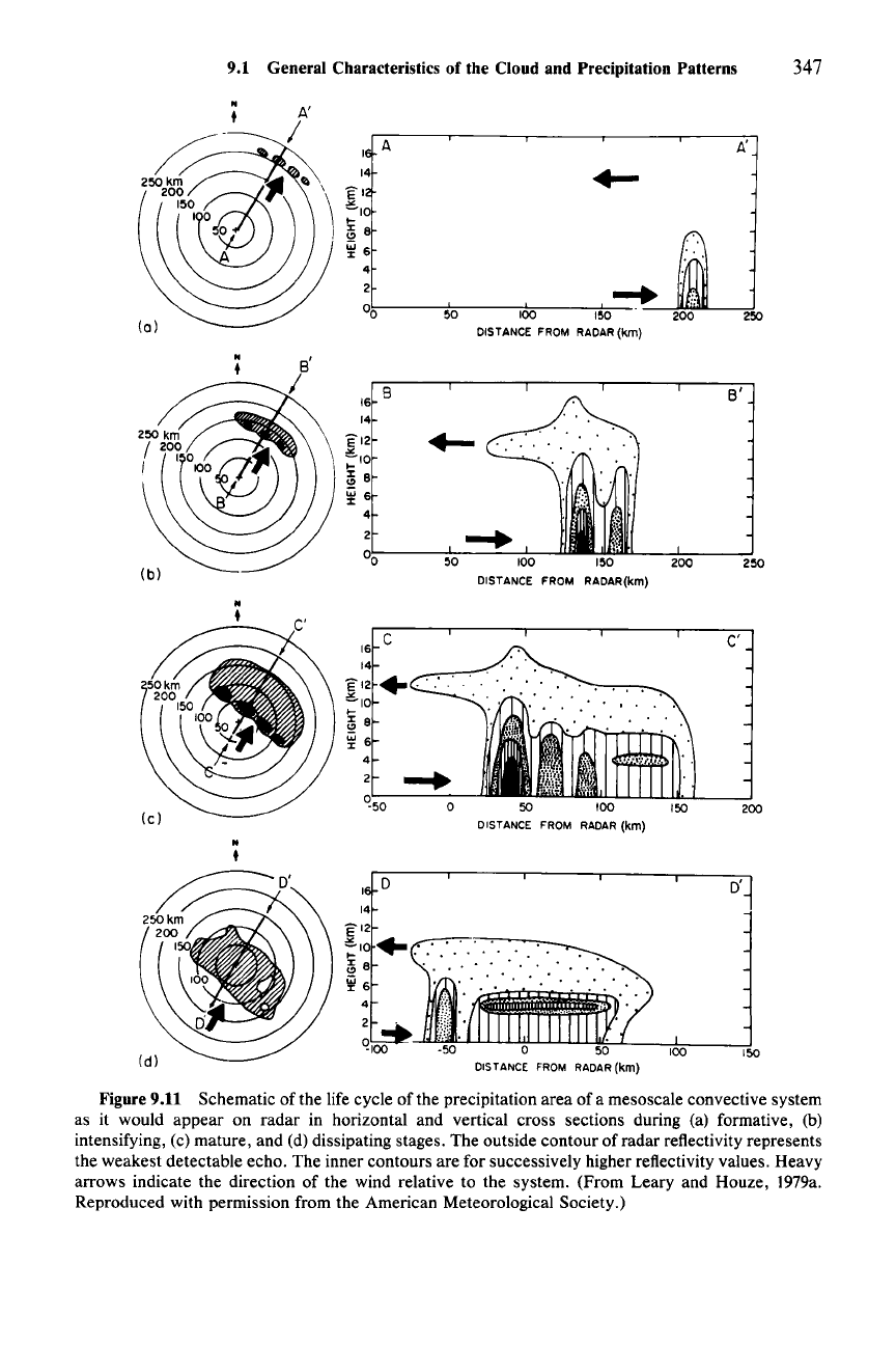
100
150
Figure 9.11 Schematic of the life cycle of the precipitation area
ofa
mesoscale convective system
as it would appear on radar in horizontal and vertical cross sections during (a) formative, (b)
intensifying, (c) mature, and (d) dissipating stages. The outside contour of radar reflectivity represents
the weakest detectable echo. The inner contours are for successively higher reflectivity values. Heavy
arrows indicate the direction of the wind relative to the system. (From Leary and Houze, I979a.
Reproduced with permission from the American Meteorological Society.)
348 9 Mesoscale Convective Systems
of which it weakens and becomes a component of a region of stratiform precipita-
tion falling from the midlevel base
of
the general stratiform cloud shield of the
mesoscale convective system. When several neighboring cells reach this stage,
they may become indistinguishable from each other and together can form an
extensive region
of
stratiform rain with a continuous melting layer. A stratiform
region formed in this way may be as large as 200 km in horizontal dimension. This
life cycle is essentially the sequence of events illustrated in Fig. 6.11, which was
presented to explain how a region of nimbostratus can evolve from a group of
deep convective elements.
Cloud and precipitation are detrained from the tops of active cells. If the upper-
level winds carry the condensate away from the rain area, an overhang of radar
echo can form, as shown in the schematic in Fig.
9.llc.
If, on the other hand, the
winds aloft carry the detrained condensate inward, toward the center of the rain
area, the detrained condensate combines with the stratiform clouds and precipita-
tion formed from the old cells.
As long as new cells continue to form, the precipitation region remains in a
mature stage and consists of a combination of active cells, weakening cells, and
stratiform precipitation. In the
dissipating stage of the rain area (Fig. 9.11d), the
formation of new convective cells diminishes, and the feature consists of a broad
area of slowly weakening stratiform precipitation with weak, embedded convec-
tive cells.
The area-integrated mass of rainfall from the precipitation area of a mesoscale
convective system reflects the life cycle
just
described. A typical example of the
rain from a mesoscale convective system is shown in Fig. 9.12. During the first
6-8
h, corresponding to the formative and intensifying phases of the precipitation
area, the rainfall was dominated by the convective cells. After this time, the
stratiform precipitation accounted for an increasing proportion of the total rainfall
until, midway through the lifetime
of
the rain area, the stratiform and convective
regions were contributing approximately equally to the mass of rain falling from
the cloud system.
Although the rain rate in the stratiform region is considerably less than in the
convective cells, the great
area
covered by the stratiform rain implies a large total
fallout
of
water mass
over
the whole region. In some cases, the stratiform rain
amount actually surpasses the convective amount during the mature phase of the
rain area. The stratiform component continues to be strong into the dissipating
stage of the rain area.
The
convective and stratiform components both gradually
weaken.
It
is typical for the stratiform rain to account for 25-50%
of
the total rain
integrated
over
the lifetime of a mesoscale convective system. In the example
shown in Fig. 9.12 the stratiform rain accounted for 40% of the total time- and
area-integrated rainfall.
9.2 The Squall Line with Trailing Stratiform Precipitation
9.2.1 General Features
We have noted that in both the tropics and midlatitudes, one type of precipitation
structure that
can
occur
in a mesoscale convective system is a sharply defined
