Houze Robert A., Jr. Cloud Dynamics
Подождите немного. Документ загружается.


8.8 The Tornado 309
Fig. 8.35.
For
weakly rotating updrafts, it is found that the horizontal pressure
gradient along the ground is adverse, and the outer flow separates from the surface
and bypasses the corner region, preventing the formation of a strong vortex near
the ground (Fig. 8.35a). Then, with increasing swirl ratio, a one-cell vortex be-
comes established (Fig. 8.35b), followed by a two-cell vortex whose downdraft
does not penetrate to the ground (Fig. 8.35c), then a two-cell vortex penetrating all
the way to the surface (Fig. 8.35d), and finally formation of multiple vortices (Fig.
8.35e).
The evolution of the two-cell vortex between the stages represented by Fig.
8.35c and d has been found in numerical-model simulations of laboratory experi-
ments to be associated with the nearly cyclostrophic pressure perturbation mini-
mum on the central axis at low Ievels.P' As the swirl ratio increases this minimum
becomes stronger, and a downward-directed vertical pressure perturbation gradi-
ent acceleration develops along the center axis at low levels. The vortex therefore
"fills
in"
from above.
The intermediate configuration represented in Fig. 8.35c occurs at moderate
swirl. This mode, which has the one-cell structure at lower levels and a two-cell
structure higher up, has the characteristics of a general phenomenon called
vortex
breakdown.
This phenomenon is seen in a variety of flow situations.
It
is charac-
terized by an abrupt transition from a highly swirling narrow laminar
jet
to a broad
turbulent flow with greatly reduced swirl and reversed (i.e., downward) vertical
flow. An example of vortex breakdown in the laboratory setting is shown in Fig.
8.36. The breakdown point in Fig. 8.35c is the height at where the vortex under-
goes sharp transition to larger diameter, and downward motion along the axis
meets the upward motion of the intense lower-level vortex. The core is turbulent
above this stagnation point.
The vortex breakdown is very complex, and several theoretical ideas are in-
volved in its explanation.F' One is that there is a partial analogy between a
stratified flow under gravity and a rotating flow in which the role played by
gravitational acceleration in the stratified flow is analogous to that of centrifugal
acceleration in the rotating flow. When the horizontal flow speed in the
x-z plane
of a two-dimensional stratified fluid exceeds the speed of the fastest horizontally
moving gravity waves, the flow is said to be "supercritical" and disturbances are
unable to propagate upstream. Upstream and downstream boundary conditions
are matched in steady flow by sudden reduction at some location to a subcritical
flow speed and a corresponding increase in depth. This phenomenon, known as a
"hydraulic
jump,"
will be discussed in Chapter 12 (Sec. 12.2.5). Vortex break-
down is a similar transition, which can occur in rotating flows when the speed of
the fluid motion along the vertical axis of the vortex exceeds the speed of the
fastest of the downward-propagating "inertia waves," which form in response to
the centrifugal restoring force (which plays a role analogous to the Coriolis restor-
226 This physical interpretation is based on Rotunno (1977, 1986).
227 Rotunno (1979) gives a summary of these ideas and demonstrates aspects of them with a vivid
set of numerical simulations.
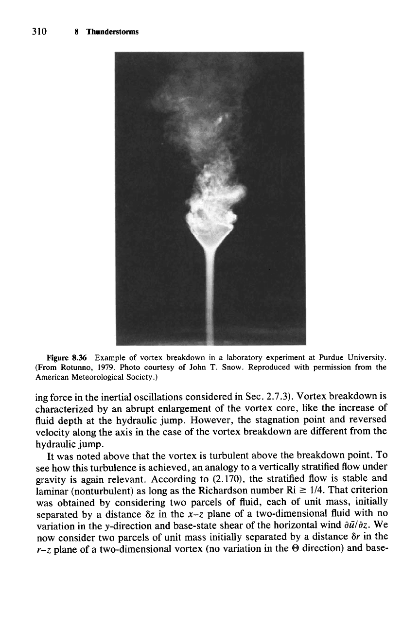
310 8 Thunderstorms
Figure 8.36 Example of vortex breakdown in a laboratory experiment at Purdue University.
(From Rotunno, 1979. Photo courtesy of John T. Snow. Reproduced with permission from the
American Meteorological Society.)
ing force in the inertial oscillations considered in Sec. 2.7.3). Vortex breakdown is
characterized by an abrupt enlargement of the vortex core, like the increase of
fluid depth at the hydraulic jump. However, the stagnation point and reversed
velocity along the axis in the case of the vortex breakdown are different from the
hydraulic jump.
It
was noted above that the vortex is turbulent above the breakdown point. To
see how this turbulence is achieved, an analogy to a vertically stratified flow under
gravity is again relevant. According to (2.170), the stratified flow is stable and
laminar (nonturbulent) as long as the Richardson number Ri
~
1/4. That criterion
was obtained by considering two parcels of fluid, each of unit mass, initially
separated by a distance
8z in the
x-z
plane of a two-dimensional fluid with no
variation in the y-direction and base-state shear of the horizontal wind
aii/az.
We
now consider two parcels of unit mass initially separated by a distance
Sr in the
r-z plane of a two-dimensional vortex (no variation in the e direction) and base-
(8.36)
8.8 The Tornado
311
state shear of the z-component of the wind aw/ar. In the absence of turbulence,
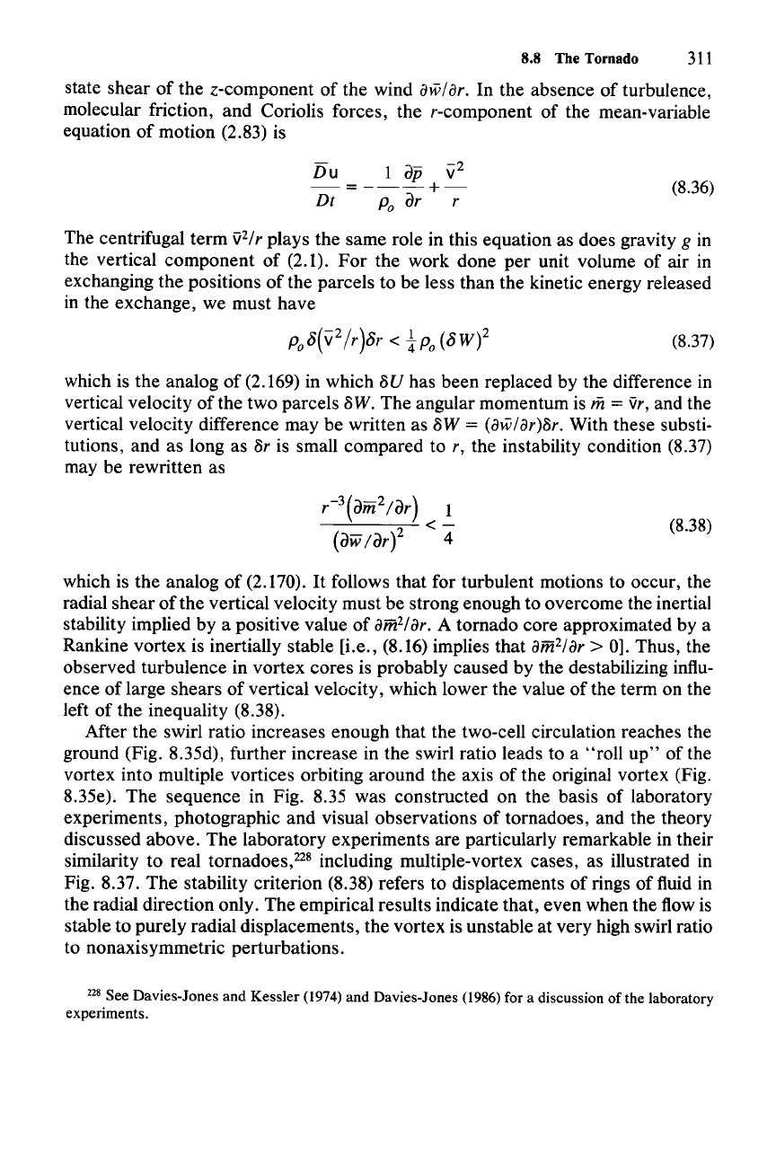
molecular friction, and Coriolis forces, the r-component of the mean-variable
equation of motion (2.83) is
Du
1
dP
\i2
-=---+-
Dt
Po
dr r
The centrifugal term
'J2/
r
plays the same role in this equation as does gravity g in
the vertical component of (2.1).
For
the work done per unit volume of air in
exchanging the positions of the parcels to be less than the kinetic energy released
in the exchange, we must have
(8.37)
which is the analog of (2.169) in which
8U
has been replaced by the difference in
vertical velocity
ofthe
two parcels 8W. The angular momentum is
iii
= 'Jr, and the
vertical velocity difference may be written as
8W = (aw/ar)8r. With these substi-
tutions, and as long as
8r is small compared to r, the instability condition (8.37)
may be rewritten as
(8.38)
which is the analog of (2.170).
It
follows that for turbulent motions to occur, the
radial shear of the vertical velocity must be strong enough to overcome the inertial
stability implied by a positive value of
amHar. A tornado core approximated by a
Rankine vortex is inertially stable [i.e., (8.16) implies that
am
2/ar
> 0]. Thus, the
observed turbulence in vortex cores is probably caused by the destabilizing influ-
ence of large shears of vertical velocity, which lower the value of the term on the
left of the inequality (8.38).
After the swirl ratio increases enough that the two-cell circulation reaches the
ground (Fig. 8.35d), further increase in the swirl ratio leads to a "roll
up"
of the
vortex into multiple vortices orbiting around the axis of the original vortex (Fig.
8.35e). The sequence in Fig. 8.35 was constructed on the basis of laboratory
experiments, photographic and visual observations of tornadoes, and the theory
discussed above. The laboratory experiments are particularly remarkable in their
similarity to real
tomadoes.P' including multiple-vortex cases, as illustrated in
Fig. 8.37. The stability criterion (8.38) refers to displacements of rings of fluid in
the radial direction only. The empirical results indicate that, even when the flow is
stable to purely radial displacements, the vortex is unstable at very high swirl ratio
to nonaxisymmetric perturbations.
228 See Davies-Jones and Kessler (1974) and Davies-Jones (1986) for a discussion of the laboratory
experiments.
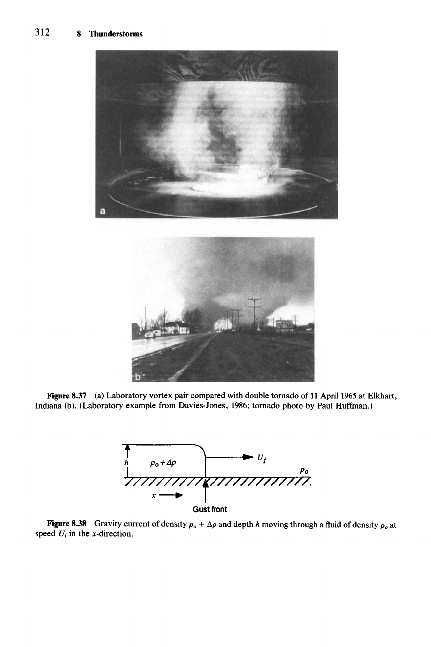
312 8 Thunderstorms
Figure8.37 (a) Laboratory vortex pair compared with double tornado of II April 1965at Elkhart,
Indiana (b). (Laboratory example from Davies-Jones, 1986; tornado photo by Paul Huffman.)
~};;~;
x-.
Gustfront
Figure8.38 Gravity current of density
Po +
8p
and depth h moving through a fluid of density Poat
speed
U, in the x-direction.
(8.40)
(8.41)
8.9 Gust Fronts
313
8.9 Gust Fronts
The outflow of downdraft air from thunderstorms along the ground is a very
important phenomenon.
It
can help to generate new thunderstorm cells, and it can
cut old cells off from their supply of buoyant air. The boundary of the advancing
outflow marks a major change in surface meteorological conditions and is thus of
interest in forecasting and nowcasting. Damaging winds-" often occur at this
boundary, which is usually referred to as the
gust
front. In this section, we
explore its dynamics.
The gust front is an example of the geophysical phenomenon called a
gravity
current,
which may be defined as a mass of high-density fluid flowing along a
horizontal bottom and displacing ambient fluid of lesser density.
230 Other exam-
ples include salt water intruding into a fresh water estuary, or muddy water
displacing fresh water at the bottom of a lake. The gravity current is driven by the
horizontal pressure gradient acting across the sharp lateral interface separating
the two fluids. The physical situation is shown in idealized form in Fig. 8.38 for a
gravity current moving at speed
Vi in the x-direction. The role of the pressure
gradient in determining the speed of the current can be seen from the x-component
ofthe
Boussinesq momentum equation (2.47) in the absence offriction or Coriolis
forces:
Du
1
ap*
- =
----
(8.39)
Dt
Po
ax
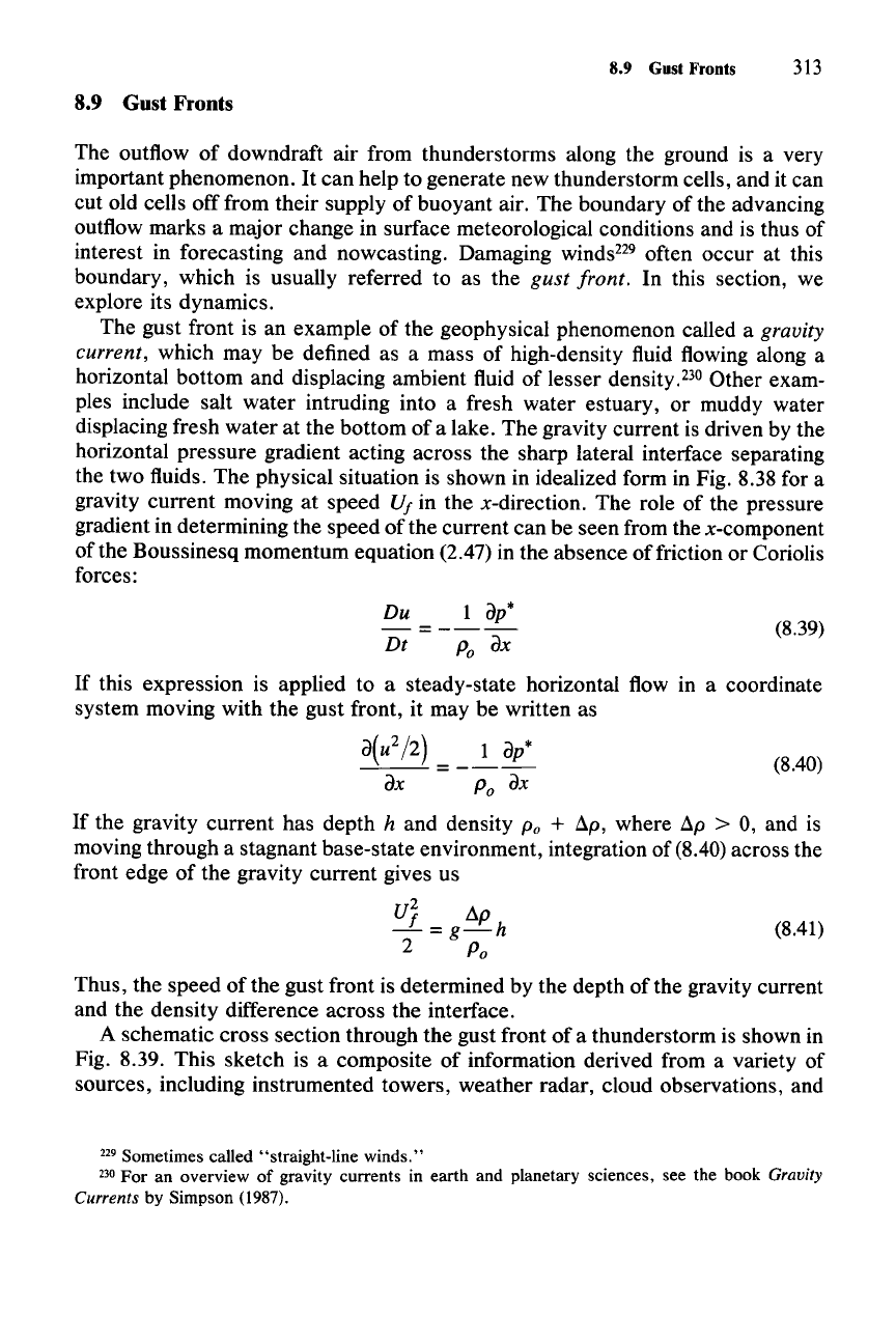
If this expression is applied to a steady-state horizontal flow in a coordinate
system moving with the gust front, it may be written as
a(u
2/2)
=
__
1
ap*
ax
Po
ax
If the gravity current has depth h and density
Po
+ ap, where ap > 0, and is
moving through a stagnant base-state environment, integration of (8.40)across the
front edge of the gravity current gives us
UJ dp
-=g-h
2 Po
Thus, the speed of the gust front is determined by the depth of the gravity current
and the density difference across the interface.
A schematic cross section through the gust front of a thunderstorm is shown in
Fig. 8.39. This sketch is a composite of information derived from a variety of
sources, including instrumented towers, weather radar, cloud observations, and
229 Sometimes called "straight-line winds."
230 For an overview of gravity currents in earth and planetary sciences. see the book Gravity
Currents
by Simpson (1987).
314 8 Thunderstorms
Slim
I
2H
WARM
AIR
Figure8.39 Schematic cross section through the gust front of a thunderstorm. (From Droegemeier
and Wilhelmson, 1987; based on earlier studies of Charba, 1974; Goff, 1975; Wakimoto, 1982; Koch,
1984. Reprinted with permission from the American Meteorological Society.)
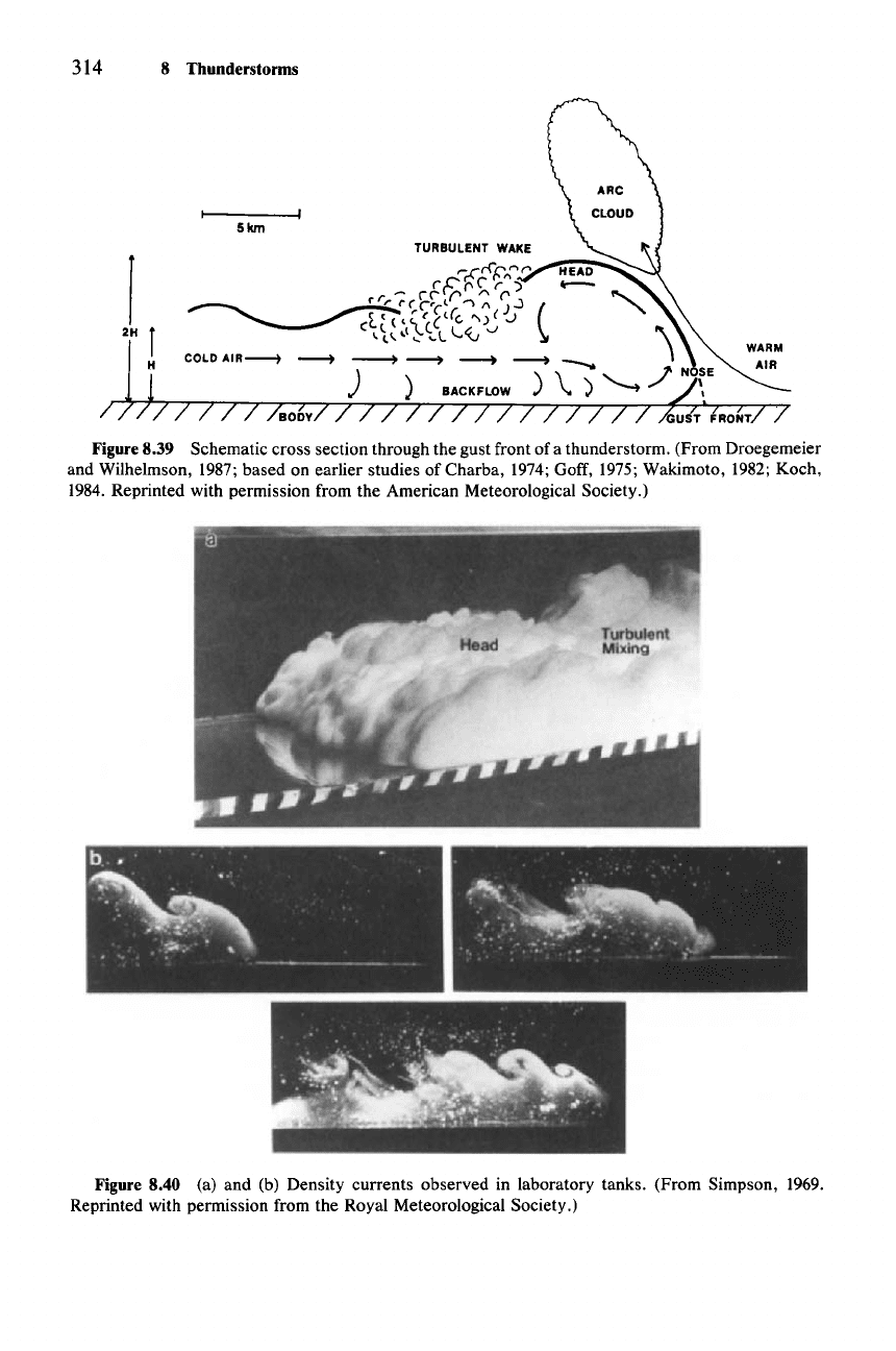
Figure 8.40 (a) and (b) Density currents observed in laboratory tanks. (From Simpson, 1969.
Reprinted with permission from the Royal Meteorological Society.)
8.9 Gust Fronts
315
time series of surface meteorological data. The structure shown is remarkably
similar to that of density currents observed in laboratory tanks (Fig. 8.40). Char-
acteristic features include the bulbous head marking the leading portion of the
current. Within the head is an overturning internal circulation. Following the head
is a turbulent wake, which is, in turn, followed by several waves distorting the
shape of the upper boundary of the dense outflow. An arc cloud sometimes forms
in response to the lifting over the head.
Further details of the flow in thunderstorm outflows have been deduced from
cloud models of the type discussed in Sec. 7.5.3. Results from a model simulation
are shown in Figs. 8.41-8.44
.231 A shallow layer of cold air moving along the
ground enters a two-dimensional
(x-z)
model domain from the side. The inflow
enters the domain with an assigned temperature profile, depth, and vertically
averaged perturbation potential temperature. As the cold layer moves across the
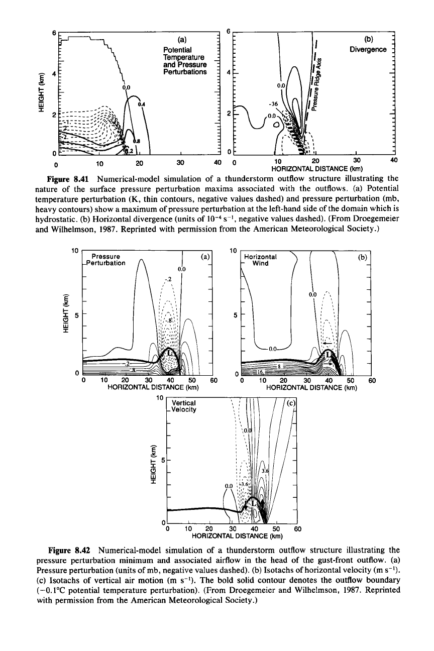
domain, the pressure perturbation at the surface is characterized by a high at its
leading edge (Fig. 8.41a). This high reflects the peak of dynamic pressure pro-
duced at the leading edge. The maximum convergence coincides with the pressure
maximum (Fig. 8.41b). From the momentum equation (8.39), we can see how this
pressure perturbation is derived from the kinetic energy of the low-level relative
flow toward the gust front, when it is stagnated by the wall of denser fluid.
If
we
follow a parcel of fluid moving in the x-direction at horizontal velocity
u = DxlDt,
then we can make the transformation
lIDt
=
u/Dx
and (8.39) can be written as
!!-(~
+
L)
= 0
(8.42)
Dx 2 Po
where Dx represents the distance between two successive locations of the fluid
parcel. If this expression is integrated along the path of a parcel moving along the
surface from some location far ahead
ofthe
gust front (where its relative motion is
toward the gust front at speed Vi and the pressure perturbation is zero) to a point
immediately ahead of the surface position of the gust front (where the relative
motion of the parcel has been reduced to 0), then the pressure perturbation at the
gust front is found to be
p* = Po
tuj
(8.43)
Thus, the pressure perturbation at the surface at a point just ahead of the den-
sity current results from the conversion of horizontal kinetic energy to enthalpy
(p*/Po)' Since the stagnation occurs ahead of the leading edge of the gravity
current, there is no hydrostatic contribution to
p* at this point.
The second maximum of pressure to the rear of the head is hydrostatic.
It
simply reflects the weight of the fluid above. The minimum of pressure separating
the two highs is, however, nonhydrostatic.
It
is associated with rotation. As can
be seen from Fig. 8.42, the low-pressure center in the middle
ofthe
head coincides
with a center of rotation, which can be inferred from the horizontal and vertical
231 These results are from a definitive paper by Droegemeier and Wilhelmson (1987).
40
(b)
Divergence
6..-------;------,-------
40
30
(a)
Potential
Temperature
and Pressure
Perturbations
20
10
10 20 30
HORIZONTALDISTANCE(km)
Figure 8.41 Numerical-model simulation of a thunderstorm outflow structure illustrating the
nature of the surface pressure perturbation maxima associated with the outflows. (a) Potential
temperature perturbation (K, thin contours, negative values dashed) and pressure perturbation (mb,
heavy contours) show a maximum of pressure perturbation at the left-hand side of the domain which is
hydrostatic. (b) Horizontal divergence (units of
10-
4
s
",
negative values dashed). (From Droegemeier
and Wilhelmson,
1987. Reprinted with permission from the American Meteorological Society.)
10
..--------------,,..-----,
10
r-----~-~-~---~
(b)
10 20 30 40 50 60
HORIZONTAL
DISTANCE
(km)
Horizontal
Wind
5
(a)
10 20 30 40 50 60
HORIZONTAL
DISTANCE
(km)
10
r-------~~~-~~~
Vertical
Velocity
Pressure
Perturbation
o~St
o
OL-_---'--_-L_-'-I.-L.=..:...JJlL...lIIL-L_---.J
o 10 20 30 40 50 60
HORIZONTAL
DISTANCE
(km)
Figure 8.42 Numerical-model simulation of a thunderstorm outflow structure illustrating the
pressure perturbation minimum and associated airflow in the head of the gust-front outflow. (a)
Pressure perturbation (units of mb, negative values dashed). (b) Isotachs of horizontal velocity (m s
").
(c) Isotachs of vertical air motion (m s
").
The bold solid contour denotes the outflow boundary
(-O.I°C potential temperature perturbation). (From Droegemeier and Wilhelmson, 1987. Reprinted
with permission from the American Meteorological Society.)
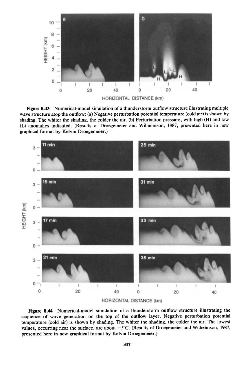
Figure 8.43 Numerical-model simulation of a thunderstorm outflow structure illustrating multiple
wave structure atop the outflow: (a) Negative perturbation potential temperature (cold air) is shown by
shading. The whiter the shading, the colder the air. (b) Perturbation pressure, with high (H) and low
(L) anomalies indicated. (Results of Droegemeier and Wilhelmson, 1987, presented here in new
graphical format by Kelvin Droegemeier.)
Figure 8.44 Numerical-model simulation of a thunderstorm outflow structure illustrating the
sequence of wave generation on the top of the outflow layer. Negative perturbation potential
temperature (cold air) is shown by shading. The whiter the shading, the colder the air. The lowest
values, occurring near the surface, are about
-5°C. (Results of Droegemeier and Wilhelmson, 1987,
presented here in new graphical format by Kelvin Droegemeier.)
317
318 8 Thunderstorms
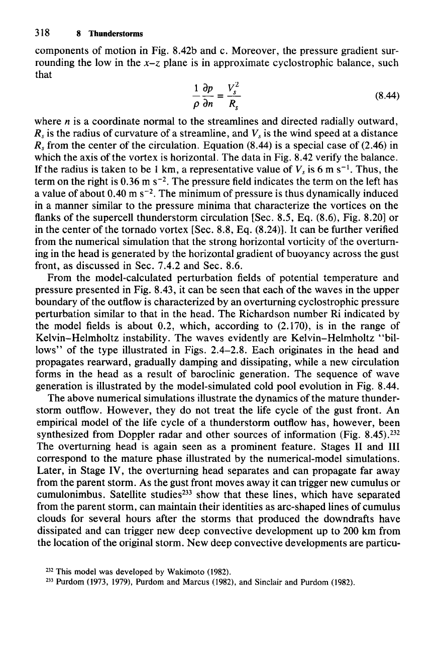
components of motion in Fig. 8.42b and c. Moreover, the pressure gradient sur-
rounding the low in the
x-z plane is in approximate cyclostrophic balance, such
that
2
1
dP
V
s
= (8.44)
P dn R,
where n is a coordinate normal to the streamlines and directed radially outward,
R, is the radius of curvature of a streamline, and V
s
is the wind speed at a distance
R, from the center of the circulation. Equation (8.44) is a special case of (2.46) in
which the axis of the vortex is horizontal. The data in Fig. 8.42 verify the balance.
If the radius is taken to be 1 km, a representative value of
V
s
is 6 m s
".
Thus, the
term on the right is 0.36 m
S-2.
The pressure field indicates the term on the left has
a value of about 0.40 m
S-2.
The minimum of pressure is thus dynamically induced
in a manner similar to the pressure minima that characterize the vortices on the
flanks of the supercell thunderstorm circulation [Sec. 8.5,
Eq,
(8.6), Fig. 8.20] or
in the center of the tornado vortex [Sec. 8.8, Eq. (8.24)].
It
can be further verified
from the numerical simulation that the strong horizontal vorticity of the overturn-
ing in the head is generated by the horizontal gradient of buoyancy across the gust
front, as discussed in Sec. 7.4.2 and Sec. 8.6.
From the model-calculated perturbation fields of potential temperature and
pressure presented in Fig. 8.43, it can be seen that each of the waves in the upper
boundary of the outflow is characterized by an overturning cyclostrophic pressure
perturbation similar to that in the head. The Richardson number Ri indicated by
the model fields is about 0.2, which, according to (2.170), is in the range of
Kelvin-Helmholtz instability. The waves evidently are Kelvin-Helmholtz "bil-
lows" of the type illustrated in Figs. 2.4-2.8. Each originates in the head and
propagates rearward, gradually damping and dissipating, while a new circulation
forms in the head as a result of baroclinic generation. The sequence of wave
generation is illustrated by the model-simulated cold pool evolution in Fig. 8.44.
The above numerical simulations illustrate the dynamics of the mature thunder-
storm outflow. However, they do not treat the life cycle of the gust front. An
empirical model of the life cycle of a thunderstorm outflow has, however, been
synthesized from Doppler radar and other sources of information (Fig.
8.45).232
The overturning head is again seen as a prominent feature. Stages II and III
correspond to the mature phase illustrated by the numerical-model simulations.
Later, in Stage IV, the overturning head separates and can propagate far away
from the parent storm. As the gust front moves away it can trigger new cumulus or
cumulonimbus. Satellite studies-" show that these lines, which have separated
from the parent storm, can maintain their identities as arc-shaped lines of cumulus
clouds for several hours after the storms that produced the downdrafts have
dissipated and can trigger new deep convective development up to 200 km from
the location of the original storm. New deep convective developments are particu-
232 This model was developed by Wakimoto (1982).
233 Purdom (1973, 1979), Purdom and Marcus (1982), and Sinclair and Purdom (1982).
