Houze Robert A., Jr. Cloud Dynamics
Подождите немного. Документ загружается.

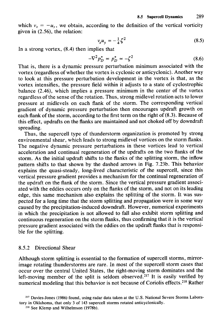
(8.5)
8.5 Supercell Dynamics
289
which V
x
= - u
y,
we obtain, according to the definition of the vertical vorticity
given in (2.56), the relation:
1
r2
VxU
y
=
-"4"
In a strong vortex, (8.4) then implies that
n2
* *
r2
-v
PD
cc
PD
cc
-"
(8.6)
That is, there is a dynamic pressure perturbation minimum associated with the
vortex (regardless of whether the vortex is cyclonic or anticyclonic). Another way
to look at this pressure perturbation development in the vortex is that, as the
vortex intensifies, the pressure field within it adjusts to a state of cyclostrophic
balance (2.46), which implies a pressure minimum in the center of the vortex
regardless of the sense of the rotation. Thus, strong midlevel rotation acts to lower
pressure at midlevels on each flank of the storm. The corresponding vertical
gradient of dynamic pressure perturbation then encourages updraft growth on
each flank of the storm, according to the first term on the right of (8.3). Because of
this effect, updrafts on the flanks are maintained and not choked off by downdraft
spreading.
Thus, the supercell type of thunderstorm organization is promoted by strong
environmental shear, which leads to strong midlevel vortices on the storm flanks.
The negative dynamic pressure perturbations in these vortices lead to vertical
acceleration and continual regeneration of the updrafts on the two flanks of the
storm. As the initial updraft shifts to the flanks of the splitting storm, the inflow
pattern shifts to that shown by the dashed arrows in Fig. 7.23b. This behavior
explains the quasi-steady, long-lived characteristic
of
the supercell, since this
vertical pressure gradient provides a mechanism for the continual regeneration of
the updraft on the flank of the storm. Since the vertical pressure gradient associ-
ated with the eddies occurs only on the flanks of the storm, and not on its leading
edge, this same mechanism also explains the splitting of the storm.
It
was sus-
pected for a long time that the storm splitting and propagation were in some way
caused by the precipitation-induced downdraft. However, numerical experiments
in which the precipitation is not allowed to fall also exhibit storm splitting and
continuous regeneration on the storm flanks, thus confirming that it is the vertical
pressure gradient associated with the eddies on the updraft flanks that is responsi-
ble for the splitting.
8.5.2 Directional Shear
Although storm splitting is essential to the formation of supercell storms, mirror-
image rotating thunderstorms are rare. In most of the supercell storm cases that
occur over the central United States, the right-moving storm dominates and the
left-moving member of the split is seldom observed.l'?
It
is easily verified by
numerical modeling that this behavior is not because of Coriolis effects.?" Rather
217 Davies-Jones (1986) found, using radar data taken at the U.S. National Severe Storms Labora-
tory in Oklahoma, that only 3 of 143 supercell storms rotated anticyclonically.
218 See Klemp and Wilhelmson (l978b).
(8.8)
290 8 Thunderstorms
it is associated with the directional shear of the wind, which up to now we have
ignored.
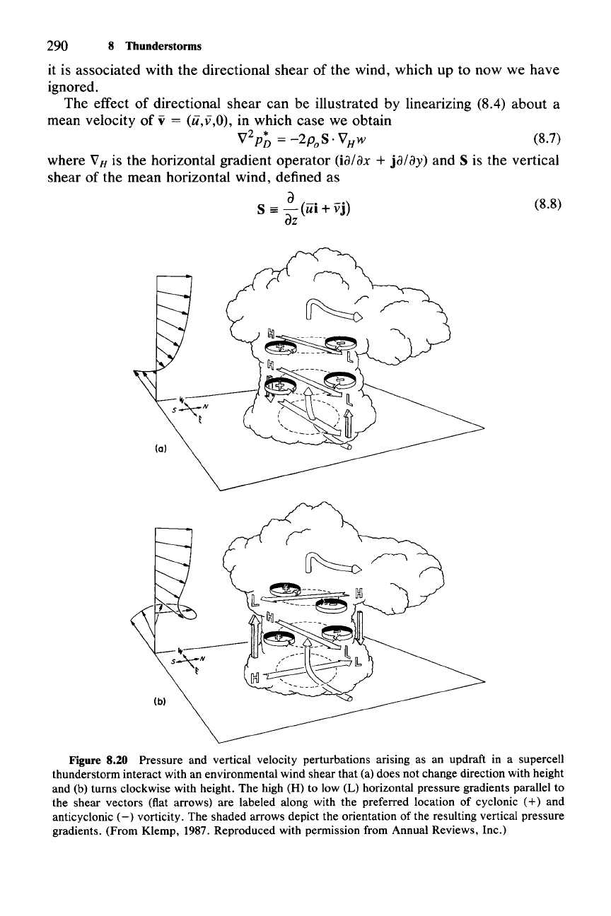
The effect of directional shear can be illustrated by linearizing (8.4) about a
mean velocity of
v = (ii,v,O), in which case we obtain
V
2
p; =
-2p
oS·
VHw (8.7)
where
VB
is the horizontal gradient operator (ia/ax + ja/ay) and S is the vertical
shear of the mean horizontal wind, defined as
a
(.
-n
S
==
- UI+VJ
az
Figure 8.20 Pressure and vertical velocity perturbations arising as an updraft in a supercell
thunderstorm interact with an environmental wind shear that (a) does not change direction with height
and (b) turns clockwise with height. The high (H) to low (L) horizontal pressure gradients parallel to
the shear vectors (flat arrows) are labeled along with the preferred location of cyclonic
(+)
and
anticyclonic
(-)
vorticity. The shaded arrows depict the orientation of the resulting vertical pressure
gradients. (From Klemp, 1987. Reproduced with permission from Annual Reviews, Inc.)
8.6 Transition of the Supercell to the Tornadic Phase
291
40
20
~
~
In
.s
200
;>.
sfc
20
u (m 5-
1)
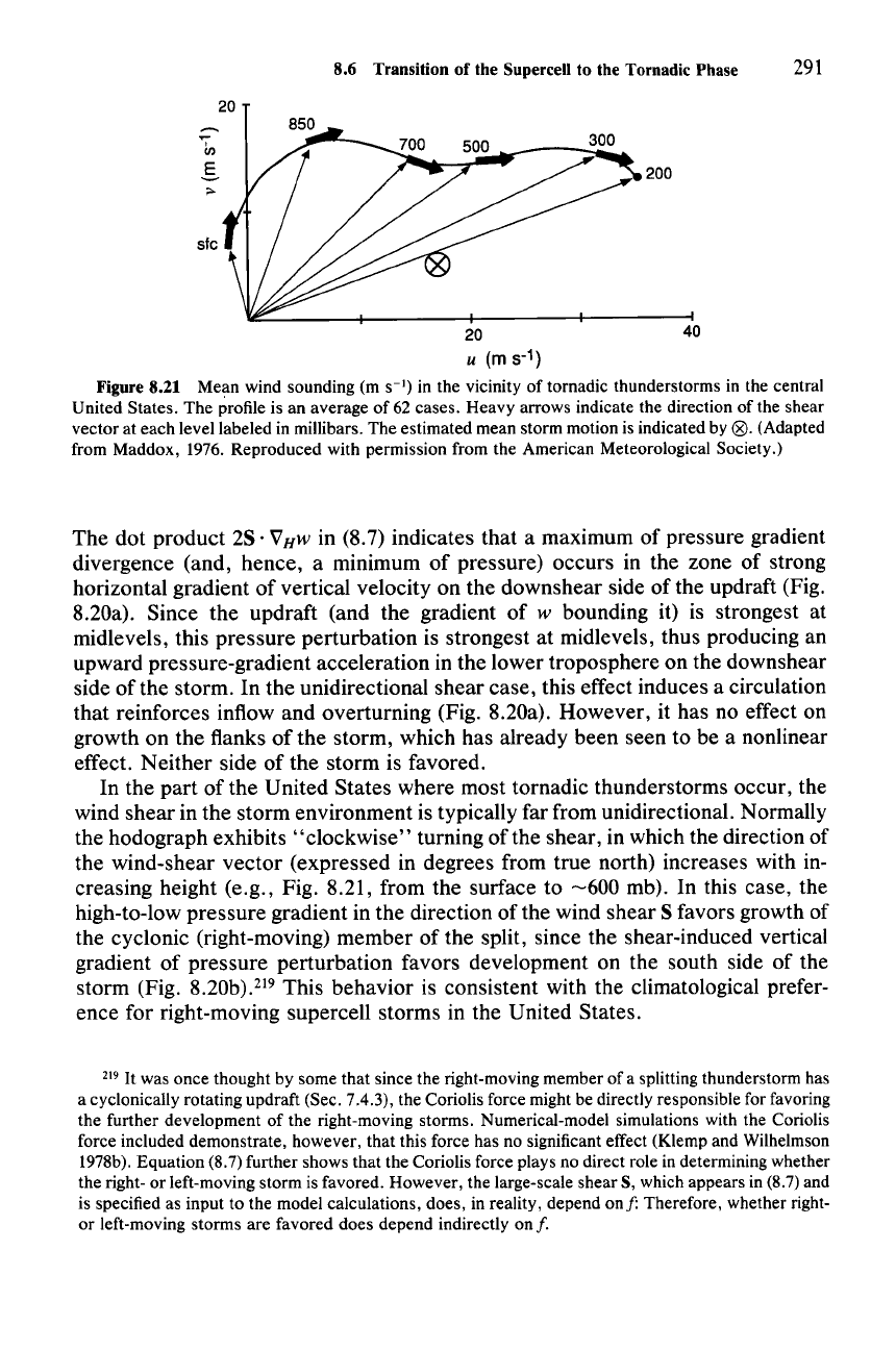
Figure 8.21 Mean wind sounding (m
S-I)
in the vicinity of tornadic thunderstorms in the central
United States. The profile is an average of 62 cases. Heavy arrows indicate the direction of the shear
vector at each level labeled in millibars. The estimated mean storm motion is indicated by
(8).(Adapted
from Maddox, 1976. Reproduced with permission from the American Meteorological Society.)
The dot product 2S· VHw in (8.7) indicates that a maximum of pressure gradient
divergence (and, hence, a minimum of pressure) occurs in the zone of strong
horizontal gradient of vertical velocity on the downshear side of the updraft (Fig.
8.20a). Since the updraft (and the gradient of
w bounding it) is strongest at
midlevels, this pressure perturbation is strongest at midlevels, thus producing an
upward pressure-gradient acceleration in the lower troposphere on the downshear
side
ofthe
storm. In the unidirectional shear case, this effect induces a circulation
that reinforces inflow and overturning (Fig. 8.20a). However, it has no effect on
growth on the flanks of the storm, which has already been seen to be a nonlinear
effect. Neither side of the storm is favored.
In the part of the United States where most tornadic thunderstorms occur, the
wind shear in the storm environment is typically far from unidirectional. Normally
the hodograph exhibits "clockwise" turning of the shear, in which the direction of
the wind-shear vector (expressed in degrees from true north) increases with in-
creasing height (e.g., Fig. 8.21, from the surface to
-600
mb). In this case, the
high-to-Iow pressure gradient in the direction of the wind shear S favors growth of
the cyclonic (right-moving) member of the split, since the shear-induced vertical
gradient of pressure perturbation favors development on the south side of the
storm (Fig.
8.20b).219
This behavior is consistent with the climatological prefer-
ence for right-moving supercell storms in the United States.
219
It
was once thought by some that since the right-moving member of a splitting thunderstorm has
a cyclonically rotating updraft (Sec. 7.4.3), the Coriolis force might be directly responsible for favoring
the further development of the right-moving storms. Numerical-model simulations with the Coriolis
force included demonstrate, however, that this force has no significant effect (Klemp and Wilhelmson
1978b). Equation (8.7) further shows that the Coriolis force plays no direct role in determining whether
the right- or left-moving storm is favored. However, the large-scale shear S, which appears in (8.7) and
is specified as input to the model calculations, does, in reality, depend
ou f: Therefore, whether right-
or left-moving storms are favored does depend indirectly
onf.
292
8.6 Transition of the Supercell to the Tomadic Phase
The early stages of development of the supercell thunderstorm have been depicted
in Fig. 7.23 and Fig. 8.20. During these times, strong vortices (maxima and min-
ima of
0 are produced by tilting of the horizontal vorticity inherent in the environ-
mental wind shear. These processes are depicted again in Fig. 8.22a and b. In Sec.
7.4.3 we noted that, in the splitting storm, the vortex and updraft may become
collocated as a result
ofthe
combined effects of advection and tilting [recall (7.73)]
and that the rotating updraft thus formed is referred to as the mesocyclone (Fig.
8.22c). The mesocyclone, moreover, extends to low levels to a location on the
gust front (dotted line in Fig. 8.22d). The positioning of the center of the mesocy-
clone at low levels is determined by a complex combination of tilting, advection,
and stretching [i.e., all the terms in (2.59), except those involving
f, are impor-
tant]. The vorticity development at the gust front will be discussed further below.
The mesocyclone, formed between midlevels and the low-level gust front, is the
environment in which the main tornado of the supercell forms. Locating the
mesocyclone by Doppler radar is a useful method for short-term forecasting of
tornado occurrence.
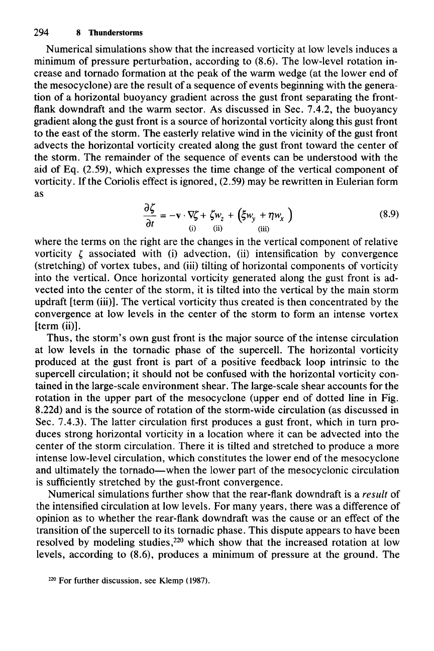
In Figs. 8.9 and 8.10, the typical location of the tornado within the supercell
was seen, in plan view, to be near the leading point of the wedge of warm air
entering the storm at low levels. The schematic view of a tornadic thunderstorm
shown in Fig. 8.23 also shows this region as one of the most likely locations for a
tornado. This empirical model of storm structure near the ground includes a
second tornado location to the south as well as features labeled
FFD
and RFD,
which are the outflows of
forward-flank and rear-flank downdrafts. This schema
represents the storm after its transition to the tornadic phase. This transition
usually occurs relatively suddenly, on a scale
-10
min, after the supercell has
evolved slowly over a period of several hours. During the rapid transition, the
low-level rotation increases, the rear-flank downdraft forms behind the updraft,
and the cold outflow and warm inflow become intertwined at low levels.
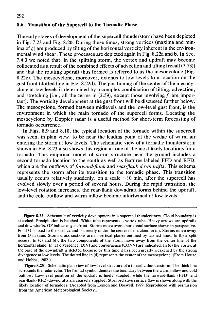
Figure 8.22 Schematic of vorticity development in a supercell thunderstorm. Cloud boundary is
sketched. Precipitation is hatched. White tube represents a vortex tube. Heavy arrows are updrafts
and downdrafts. GF indicates gust front. Storms move over a horizontal surface shown in perspective.
Point 0 is fixed to the surface and is directly under the center of the cloud in (a). Storms move away
from 0 in time. Storm cross sections are in vertical planes outlined by dashed lines. In (b) a split
occurs. In (c) and (d), the two components of the storm move away from the center line of the
horizontal plane. In (c) divergence (DIY) and convergence (CONY) are indicated. In (d) the vortex at
the base of the downdraft is deleted because by this time it has been greatly weakened by the strong
divergence at low levels. The dotted line in (d) represents the center of the mesocyclone. (From Houze
and Hobbs, 1982.)
Figure 8.23 Schematic plan view of low-level structure of a tornadic thunderstorm. The thick line
surrounds the radar echo. The frontal symbol denotes the boundary between the warm inflow and cold
outflow. Low-level position of the updraft is finely stippled, while the forward-flank (FFD) and
rear-flank (RFD) downdrafts are coarsely stippled. Storm-relative surface flow is shown along with the
likely location of tornadoes. (Adapted from Lemon and Doswell, 1979. Reproduced with permission
from the American Meteorological Society.)
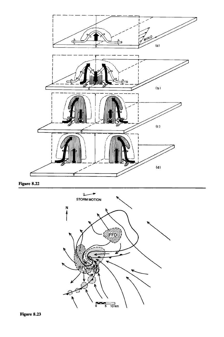
Figure 8.22
Figure 8.23
,------
I
I
I
I
I
r------::---l--
--
------,
: iJ((---
._--\
'B/--
"--""\
----.,..;.!---~
I
.'
-- I
f : I ; I
I.
I I I
I I ! I I I I
I _ -_1)7 :
GF __
----
GF (c )
u..---
STORMMOTION
N
t
(8.9)
294
8 Thunderstorms
Numerical simulations show that the increased vorticity at low levels induces a
minimum of pressure perturbation, according to (8.6). The low-level rotation in-
crease and tornado formation at the peak of the warm wedge (at the lower end of
the mesocyclone) are the result of a sequence of events beginning with the genera-
tion of a horizontal buoyancy gradient across the gust front separating the front-
flank downdraft and the warm sector. As discussed in Sec. 7.4.2, the buoyancy
gradient along the gust front is a source of horizontal vorticity along this gust front
to the east of the storm. The easterly relative wind in the vicinity of the gust front
advects the horizontal vorticity created along the gust front toward the center of
the storm. The remainder of the sequence of events can be understood with the
aid of Eq. (2.59), which expresses the time change of the vertical component of
vorticity.
Ifthe
Coriolis effect is ignored, (2.59) may be rewritten in Eulerian form
as
a,
)
- =
-v·
v,
+
,w
z
+
(;w
y
+
71wx
at
(i) (ii) (iii)
where the terms on the right are the changes in the vertical component of relative
vorticity , associated with (i) advection, (ii) intensification by convergence
(stretching) of vortex tubes, and
(iii) tilting of horizontal components of vorticity
into the vertical. Once horizontal vorticity generated along the gust front is ad-
vected into the center of the storm, it is tilted into the vertical by the main storm
updraft [term (iii)]. The vertical vorticity thus created is then concentrated by the
convergence at low levels in the center of the storm to form an intense vortex
[term (ii)].
Thus, the storm's own gust front is the major source of the intense circulation
at low levels in the tornadic phase of the supercell. The horizontal vorticity
produced at the gust front is part of a positive feedback loop intrinsic to the
supercell circulation; it should not be confused with the horizontal vorticity con-
tained in the large-scale environment shear. The large-scale shear accounts for the
rotation in the upper part of the mesocyclone (upper end of dotted line in Fig.
8.22d) and is the source of rotation of the storm-wide circulation (as discussed in
Sec. 7.4.3). The latter circulation first produces a gust front, which in turn pro-
duces strong horizontal vorticity in a location where it can be advected into the
center of the storm circulation. There it is tilted and stretched to produce a more
intense low-level circulation, which constitutes the lower end of the mesocyclone
and ultimately the
tornado-when
the lower part of the mesocyclonic circulation
is sufficiently stretched by the gust-front convergence.
Numerical simulations further show that the rear-flank downdraft is a
result of
the intensified circulation at low levels.
For
many years, there was a difference of
opinion as to whether the rear-flank downdraft was the cause or an effect of the
transition of the supercell to its tornadic phase. This dispute appears to have been
resolved by modeling studies.P' which show that the increased rotation at low
levels, according to (8.6), produces a minimum of pressure at the ground. The
220 For further discussion, see Klemp (1987).
8.7 Nonsupercell Tornadoes and Waterspouts
295
resulting downward-directed vertical pressure-gradient acceleration induces the
rear-flank downdraft. Part of the diverging outflow from the rear-flank downdraft
spreads forward rapidly enough that the main updraft and its associated tornado
become cut off from the warm inflow. A new storm updraft center forms to the
south. This location coincides with the southern tornado location in Fig. 8.23. The
cutting off of the main updraft by the outflow from the rear-flank downdraft is
sometimes referred to as
"occlusion."
Since the processes that create the tornado
also lead to the rear-flank downdraft and the cutting off of the main updraft from
its source of warm air, the tornado is usually associated with a weakening super-
cell updraft.
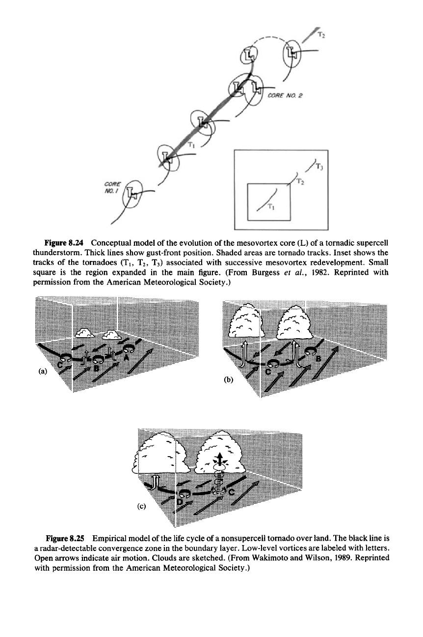
After the old updraft is cut off and the new one forms, all the processes can
repeat, with new updraft, new tornado, and new rear-flank downdraft. Repetition
of these processes can lead to sequences of tornadoes, as indicated in Fig. 8.24.
8.7 Nonsupercell Tornadoes and Waterspouts
So far we have considered only tornadoes that occur in the context of supercell
thunderstorms. A large number of intense vortices that form in association with
cumulus congestus or developing cumulonimbus are not of the supercell variety.
Over water these usually take the form of waterspouts. Generally, these vortices
are weak in comparison to a supercell tornado. However, especially over land,
vortices associated with nonsupercell convective clouds can occasionally reach
tornado strength and be quite damaging. An empirical model of the life cycle of a
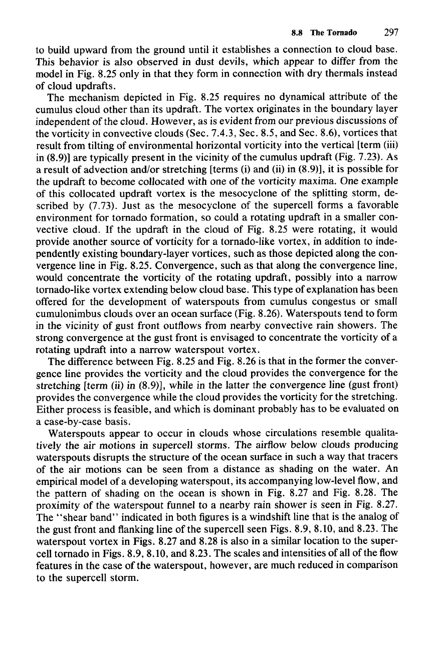
nonsupercell tornado over land is shown in Fig. 8.25. This type of tornado occurs
when a developing convective cloud is located above a spot of intensified local
vertical vorticity in the boundary layer. Often these local maxima of boundary-
layer vorticity are found along convergence lines in the boundary layer, as indi-
cated at points A, B, and C in Fig. 8.25. The same convergence line may provide
the uplift for convective cloud development. However, the cloud may develop for
other reasons and simply became located over the convergence line. Also, the
boundary-layer vorticity maximum could be produced at other types of locations.
For
example, it might be topographically produced.P' Regardless
ofthe
origins of
the cloud and the boundary-layer vorticity maxima, once a developing cloud and a
vorticity maximum become vertically aligned, tornado development can occur, as
shown in Fig. 8.25c at location C. The mechanism of development is thought to be
vortex stretching [i.e.,
'w
z
'
term (ii) in (8.9)]. Strong convergence, and hence
stretching, occurs between the strong updraft at cloud base (where
W - 1-10 m
S-I)
and the ground (where W = 0). The tornado formed in this manner is observed
221 On 9 April 1991, a nonsupercell tornado occurred over the coast of Puget Sound, near Silver-
dale, Washington.
It
appears that this tornado occurred when boundary-layer vorticity was produced
by flow around steep jagged terrain along the coastal area (Colman, 1992).When a developing cumulus
congestus or small cumulonimbus cloud moved over this region of boundary-layer vorticity, the
tornado developed and was seen from the Atmospheric Sciences-Geophysics Building at the Univer-
sity of Washington.
C~~f
(fj;j-
""7
Figure8.24 Conceptual model of the evolution of the mesovortex core (L) of a tornadic supercell
thunderstorm. Thick lines show gust-front position. Shaded areas are tornado tracks. Inset shows the
tracks of the tornadoes
(T"
T
z
, T
3
)
associated with successive mesovortex redevelopment. Small
square is the region expanded in the main figure. (From Burgess et al., 1982. Reprinted with
permission from the American Meteorological Society.)
Figure8.25 Empirical model of the life cycle of a nonsupercell tornado over land. The black line is
a radar-detectable convergence zone in the boundary layer. Low-level vortices are labeled with letters.
Open arrows indicate air motion. Clouds are sketched. (From Wakimoto and Wilson, 1989. Reprinted
with permission from the American Meteorological Society.)
8.8 The Tornado
297
to build upward from the ground until it establishes a connection to cloud base.
This behavior is also observed in dust devils, which appear to differ from the
model in Fig. 8.25 only in that they form in connection with dry thermals instead
of cloud updrafts.
The mechanism depicted in Fig. 8.25 requires no dynamical attribute of the
cumulus cloud other than its updraft. The vortex originates in the boundary layer
independent of the cloud. However, as is evident from our previous discussions of
the vorticity in convective clouds (Sec. 7.4.3, Sec. 8.5, and Sec. 8.6), vortices that
result from tilting of environmental horizontal vorticity into the vertical [term (iii)
in (8.9)] are typically present in the vicinity of the cumulus updraft (Fig. 7.23). As
a result of advection and/or stretching [terms
(i) and (ii) in (8.9)], it is possible for
the updraft to become collocated with one of the vorticity maxima. One example
of this collocated updraft vortex is the mesocyclone of the splitting storm, de-
scribed by (7.73).
Just
as the mesocyclone of the supercell forms a favorable
environment for tornado formation, so could a rotating updraft in a smaller con-
vective cloud. If the updraft in the cloud of Fig. 8.25 were rotating, it would
provide another source
of
vorticity for a tornado-like vortex, in addition to inde-
pendently existing boundary-layer vortices, such as those depicted along the con-
vergence line in Fig. 8.25. Convergence, such as that along the convergence line,
would concentrate the vorticity of the rotating updraft, possibly into a narrow
tornado-like vortex extending below cloud base. This type of explanation has been
offered for the development of waterspouts from cumulus congestus or small
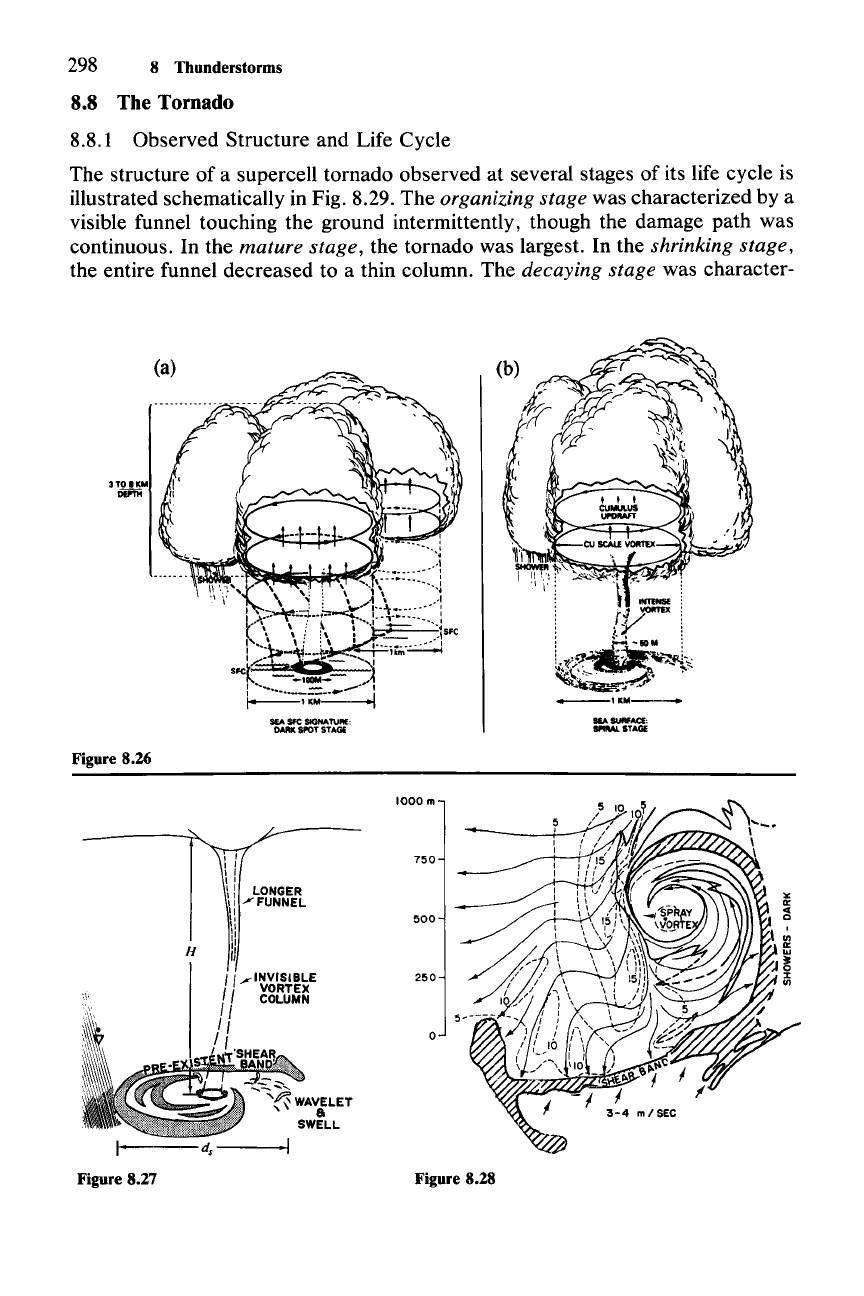
cumulonimbus clouds over an ocean surface (Fig. 8.26). Waterspouts tend to form
in the vicinity of gust front outflows from nearby convective rain showers. The
strong convergence at the gust front is envisaged to concentrate the vorticity of a
rotating updraft into a narrow waterspout vortex.
The difference between Fig. 8.25 and Fig. 8.26 is that in the former the conver-
gence line provides the vorticity and the cloud provides the convergence for the
stretching [term (ii) in (8.9)], while in the latter the convergence line (gust front)
provides the convergence while the cloud provides the vorticity for the stretching.
Either process is feasible, and which is dominant probably has to be evaluated on
a case-by-case basis.
Waterspouts appear to occur in clouds whose circulations resemble qualita-
tively the air motions in supercell storms. The airflow below clouds producing
waterspouts disrupts the structure of the ocean surface in such a way that tracers
of the air motions can be seen from a distance as shading on the water. An
empirical model of a developing waterspout, its accompanying low-level flow, and
the pattern of shading on the ocean is shown in Fig. 8.27 and Fig. 8.28. The
proximity of the waterspout funnel to a nearby rain shower is seen in Fig. 8.27.
The
"shear
band"
indicated in both figures is a windshift line that is the analog of
the gust front and flanking line of the supercell seen Figs. 8.9, 8.10, and 8.23. The
waterspout vortex in Figs. 8.27 and 8.28 is also in a similar location to the super-
cell tornado in Figs. 8.9, 8.10, and 8.23. The scales and intensities of all of the flow
features in the case of the waterspout, however, are much reduced in comparison
to the supercell storm.
298 8 Thunderstorms
8.8 The Tornado
8.8.1 Observed Structure and Life Cycle
The structure of a supercell tornado observed at several stages of its life cycle is
illustrated schematically in Fig. 8.29. The
organizing stage was characterized by a
visible funnel touching the ground intermittently, though the damage path was
continuous. In the
mature stage, the tornado was largest. In the shrinking stage,
the entire funnel decreased to a thin column. The decaying stage was character-
SEA
SURFACE:
SPtML
STAGE
Figure 8.26
o
250
750
500
1000m
, I
I I
.,
II
\: LONGER
Ii
/FUNNEL
I,
\1
H
II
'
I,'
/1~XWi~~E
, COLUMN
"
I 1
I,
Figure 8.27 Figure 8.28
