Houze Robert A., Jr. Cloud Dynamics
Подождите немного. Документ загружается.

5.1 Fog and Stratus in a Boundary Layer Cooled from Below
149
decreasing to l20e at a height of 0.1 m. The atmosphere is assumed to be isother-
mal at l20e up to a height of 0.5 km, decreasing to 11°e at 1 km and to - 3°e at
3 km. Initial soil temperature is assumed to increase to
15Se
at a depth of
-5
em
and then to decrease gradually to 15°e at a depth of
-1
m. Relative humidity at the
initial time is assumed to be 80% up to a height of 0.5 km, then to decrease linearly
to 60% at 3 km. The wind at the top of the domain (3-km altitude) is assumed to be
geostrophic and 2 m s
".
Atmospheric aerosol particles activated as a function of
relative humidity to form embryo droplets, and appropriate schemes for comput-
ing solar and infrared radiation are employed. Explicit equations are used for
predicting the soil temperature and liquid water content down to a depth of 1 m
below the ground.
From 1800to 2000LST in the example, the radiative cooling is seen to produce
a temperature inversion rapidly. Thus, the height of the boundary layer drops
quickly to near the earth's surface. The geostrophic wind layer, lying just above
the boundary layer, thus drops almost to the ground. After 2000 LST, the rate of
surface cooling decreases considerably, but the inversion continues to increase in
intensity.
It
begins to rise above the surface as turbulent mixing becomes stronger
(as indicated by the increase in exchange coefficient shown in Fig. 5.3d). The
increased mixing is related to the intensifying shear across the inversion layer.
The mixing in the stable layer shifts some of the surface cooling to higher levels,
just
below the inversion. By 2300 LST cooling below the inversion layer is
suffi-
ciently strong that the fog begins to form (as indicated by the appearance of liquid
water in Fig. 5.3b). At this time, the strong effect of the fog on the radiation and
thus on the generation of turbulence via cooling aloft is seen as the inversion layer
suddenly jumps
-10
m upward (Fig. 5.3a). From 0000 to 0200 LST, the inversion
layer continues to rise and the strongest cooling begins to occur at the top of the
fog layer, rather than at the surface (Fig. 5.3c). As the inversion layer continues to
rise, the turbulence continues to increase as the eddies are freer to move about in
the deepening boundary layer. The turbulence continues to transfer heat down-
ward, and by
just
after 0200 LST the minimum temperature lifts off the ground to a
position
just
below the inversion layer bounding the top of the fog. This point in
time marks the beginning of a series of oscillations in the fog, which are probably
the model's attempt to produce a convective mixed layer in response to the
radiative cooling at the top of the fog layer. The net effect of the mixing is to bring
liquid water up to higher levels, and the fog layer deepens through the night. Just
after 0600 LST, the upper portion of the fog decouples from the lower portion and
the oscillations cease. The upper part thus becomes a stratus layer, and only a
weak layer of fog is left below. As we will see in the next subsection, it is typical
for this layering to occur in fog and stratus in the stable boundary layer. Green-
house warming below the base of the upper stratus is apparently too great to allow
condensation in the layer between the stratus and the weaker fog below. At
sunrise, the fog layer dissipates to a thin ground fog, which, after 0750 LST,
somewhat surprisingly increases in depth, as dew and soil moisture are evapo-
rated. After 1030, as the insolation intensifies, only high relative humidity and
haze persist.
150 5 Shallow-Layer Clouds
5.1.4 Arctic Stratus
In the simulation
of
radiation fog development illustrated in Fig. 5.3, the fog
deepens as a result of the turbulent mixing, and the radiative cooling at the top of
the fog layer encourages stronger mixing, which further deepens the layer until
finally the main cloud layer separates from the lower layer of weak fog and
becomes a layer of stratus aloft. But soon after this occurs the whole process is
terminated by the rising of the sun, rapid solar heating of the boundary layer, and
dissolution
ofthe
cloud. Had there been no diurnal cycle and had the surface layer
been maintained at a constant temperature, the stratus layer and the lower fog
layer might have reached an equilibrium and persisted indefinitely. This latter,
hypothetical case is similar to what actually occurs over the Arctic Basin during
the summer months, when the melting pack ice comprises a widespread uniform
lower boundary (of temperature O°e) over which warm air from the south moves.
As the warmer air is chilled, condensation can occur in the lower boundary layer.
Stratus cloud evolves,
whichis
never dissolved because the sun remains at a
constant position, very low in the sky. As a result of this process, the Arctic Basin
is noted for its ever-present widespread summertime stratus. During the summer,
the monthly mean cloud amount is
over
80%, and low clouds are the dominant
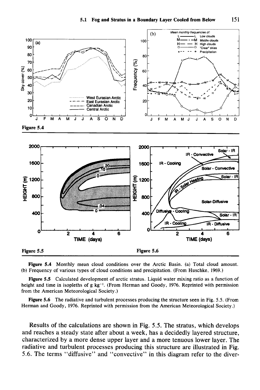
type (Fig. 5.4).
The formation of arctic stratus has been simulated numerically from the same
basic equations [(5.2)-(5.7)] used to describe the nighttime radiation fog in Sec.
5.1.3.
121
Somewhat different parameterizations for the radiation, turbulence, and
condensation were used in the equations. The basic idea of the calculation is the
same, however, except that in this case there is a nonzero basic-state (geo-
strophic) horizontal flow v
g
,
in which the air is envisaged to be moving in the
x-direction
over
a lower surface of ice. The basic current is assumed to be con-
stant with respect to height in the layer of interest. The form of (5.2)-(5.7) then
remains unchanged, as long as the time derivative is simply considered to be
calculated in a coordinate system moving with the basic current. The equations
are integrated in time as before, but under rather simpler conditions. There is no
need for a complicated treatment
of
the lower boundary, which is considered to be
melting ice. The temperature is simply maintained at
ooe
at the surface. There is
also no diurnal variation of solar radiation; the sun is held at a fixed position low in
the sky (zenith angle 74°).
The
air moving
over
the surface is initially 4°C at the
surface and has a potentially stable lapse rate characterized by
aOelaz
= 1°C km"
and 90% relative humidity. To correspond to conditions
over
the polar region, a
mean downward vertical velocity (of the order of a few tenths of a millimeter
per
second) is assumed, and a vertical advection term is added to the thermodynamic
equation.
It
is found that this term is negligible compared to the radiative and
turbulent terms,
but
its inclusion is nonetheless illustrative of how stratiform
clouds need not depend on lifting for their existence. Indeed, they
can
thrive in an
environment of mean
downward motion.
121 For the detailed account of how the equations are set up, see the original paper by Herman and
Goody (1976), on which this discussion is based.
5.1 Fog and Stratus in a Boundary Layer Cooled from Below
151
M9an monthly frequencies of:
L--L
Low clouds
M-
-
-M
Middleclouds
H-
- H High clouds
0--0
"Clear" skies
*-- --
I/o:
Precipitation
100
(a)
90
80
70
~
60
~
50
8
~
40
(/)
30
20
10
0
J
F
M
A
Figure 5.4
West Eurasian Arctic
-_._-
East Eurasian Arctic
-----
Canadian Arctic
---
Central Arctic
MJ
J
ASOND
100
80
(b)
F M A M J A
SON
D
2000
o-----.----..---.--..,.....--r--....-......,
Solar
-IR
Solar-Diffusive
1600
g1200
i
w 800
:I:
400
o
Figure 5.5
2 4
TIME (days)
6
1600
Figure 5.6
IR -Cooling
2 4
TIME(days)
Solar·IR
Solar
·IR
6
Figure 5.4 Monthly mean cloud conditions over the Arctic Basin. (a) Total cloud amount.
(b) Frequency of various types of cloud conditions and precipitation. (From Huschke,
1969.)
Figure 5.5 Calculated development of arctic stratus. Liquid water mixing ratio as a function of
height and time in isopleths of g kg-I. (From Herman and Goody,
1976. Reprinted with permission
from the American Meteorological Society.)
Figure 5.6 The radiative and turbulent processes producing the structure seen in Fig. 5.5. (From
Herman and Goody,
1976. Reprinted with permission from the American Meteorological Society.)
Results of the calculations are shown in Fig. 5.5. The stratus, which develops
and reaches a steady state after about a week, has a decidedly layered structure,
characterized by a more dense upper layer and a more tenuous lower layer. The
radiative and turbulent processes producing this structure are illustrated in Fig.
5.6. The terms "diffusive" and "convective" in this diagram refer to the diver-
152 5 Shallow-Layer Clouds
gence of the turbulent flux under stable and unstable conditions, respectively. As
the warm air moves over the ice, the boundary layer is rapidly cooled by contact
with the surface, and turbulent mixing rapidly spreads the cooling upward. In
slightly more than a day's time, the diffusive cooling together with infrared cool-
ing leads to condensation. Once the cloud forms, the radiative regime is greatly
altered by the absorptive properties of the droplets. The upper, more dense cloud
layer becomes unstable by long-wave loss from the top of the cloud, and a radia-
tive-convective balance is established in the upper cloud layer. Convective
warming is approximately equal to radiative cooling at the top, while the convec-
tive cooling balances the heating by solar absorption in the interior. The upper
cloud retains this character as the steady-state configuration is approached toward
the end of the week. The lower, more tenuous cloud layer is characterized by a
general balance between the solar heating penetrating into
it
from above and the
diffusive cooling from below. The clear layer separating the upper and lower
clouds is in a state of purely radiative equilibrium. Intense heating produced by a
greenhouse mechanism precludes condensation in this layer.
122 Another such radi-
ative equilibrium layer exists
just
below the base of the lower cloud.
The fact that no fog occurs
just
above the surface during the first hour is a
feature of the turbulence parameterization used. When a different, weaker eddy
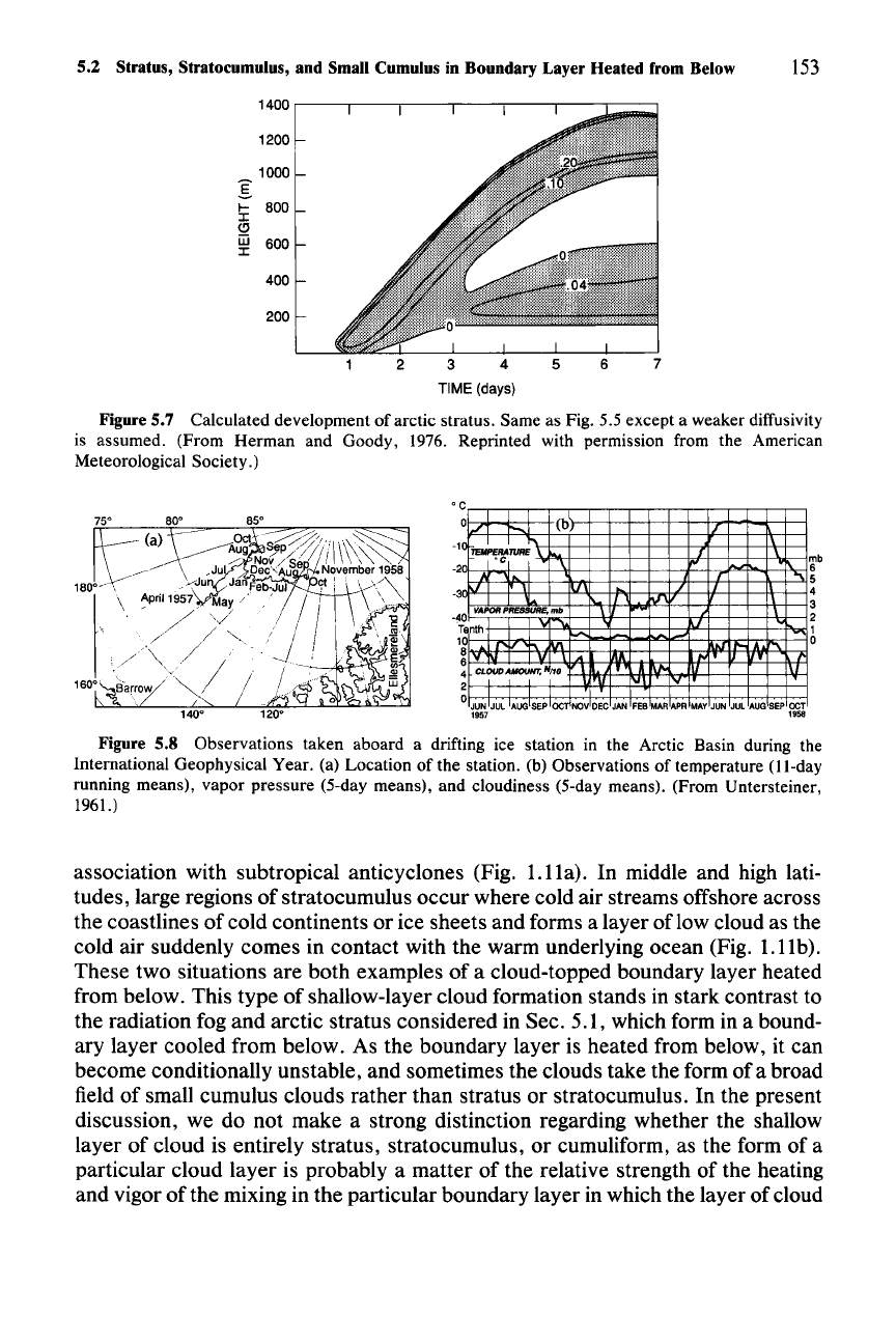
mixing was adopted, the result in Fig. 5.7 was obtained. In this case, fog formed
first at the surface and then lifted, as in the case of radiation fog (Fig. 5.3). In this
case the steady state is reached and maintained since there is no diurnal cycle to
terminate the cloud by the sun rising higher in the sky. When no turbulent fluxes
were allowed at all, the lower cloud layer never left the surface, but the cloud
nonetheless split into two layers after 3.5 days. These results suggest that in the
Arctic, generally persistent layered stratus should prevail, with fog occasionally
appearing when the mixing is especially weak. This inference from the calcula-
tions is borne out by experience.
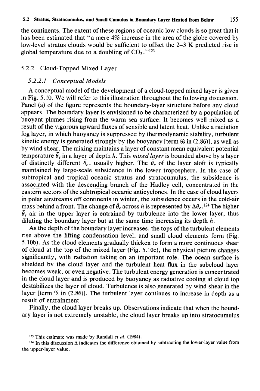
For
example, observers aboard a drifting ice
station in the Arctic Basin during the International Geophysical Year observed
sky coverage to be over eight-tenths on average throughout the summer months of
1957
and
1958
(Fig. 5.8). These clouds have been described by Professor N.
Untersteiner, who was present on the ice station for 366 days, as almost continu-
ously present low stratus, of a
"boring"
character, interrupted only occasionally
by breaks in the cloud cover and occasional periods of fog.
5.2 Stratus, Stratocumulus, and Small Cumulus in a
Boundary Layer Heated from Below
5.2.1 General Considerations
Satellite pictures show that great sheets of stratus and stratocumulus are almost
always present over the oceans at subtropical latitudes to the west of continents in
122 See Appendix B of Herman and Goody
(1976)
for a theoretical treatment of the greenhouse
mechanism.
5.2 Stratus, Stratocumulus, and Small Cumulus in Boundary Layer Heated from Below
153
1400
1200
1000
I
I-
800
I
Cl
iii
600
I
400
200
2
3
4
5
TIME (days)
Figure 5.7 Calculated development of arctic stratus. Same as Fig. 5.5 except a weaker diffusivity
is assumed. (From Herman and Goody, 1976. Reprinted with permission from the American
Meteorological Society.)
mb
6
5
4
3
2
1
o
19
..
1957
0
1/
(b
r---.
CTEJll'£RATURE
"-
I
'c
l
I
~
/
~.
IV
VAPOR
PRESSURE.
mb
o
\/I
.....
'"
nth
0
8
1111
N
:
CLOUDAMOUNT,NI10
11\1'0
2
'1/
IV'
0
JUN JUL AUG SEP OC NOV DEC JAN FEB MAR APR MAY JUN JUL AUG SEP OCT
-1
-2
-3
Figure 5.8 Observations taken aboard a drifting ice station in the Arctic Basin during the
International Geophysical Year. (a) Location of the station. (b) Observations of temperature (II-day
running means), vapor pressure (5-day means), and cloudiness (5-day means). (From Untersteiner,
1961.)
association with subtropical anticyclones (Fig.
Ll
la). In middle and high lati-
tudes, large regions of stratocumulus occur where cold air streams offshore across
the coastlines of cold continents or ice sheets and forms a layer oflow cloud as the
cold air suddenly comes in contact with the warm underlying ocean (Fig. 1.1lb).
These two situations are both examples of a cloud-topped boundary layer heated
from below. This type of shallow-layer cloud formation stands in stark contrast to
the radiation fog and arctic stratus considered in Sec. 5.1, which form in a bound-
ary layer cooled from below. As the boundary layer is heated from below, it can
become conditionally unstable, and sometimes the clouds take the form of a broad
field of small cumulus clouds rather than stratus or stratocumulus. In the present
discussion, we do not make a strong distinction regarding whether the shallow
layer of cloud is entirely stratus, stratocumulus, or cumuliform, as the form of a
particular cloud layer is probably a matter of the relative strength of the heating
and vigor of the mixing in the particular boundary layer in which the layer of cloud
154 5 Shallow-Layer Clouds
forms. The salient dynamics of the boundary layer leading to the formation and
maintenance of the cloud layer have much in common from case to case.
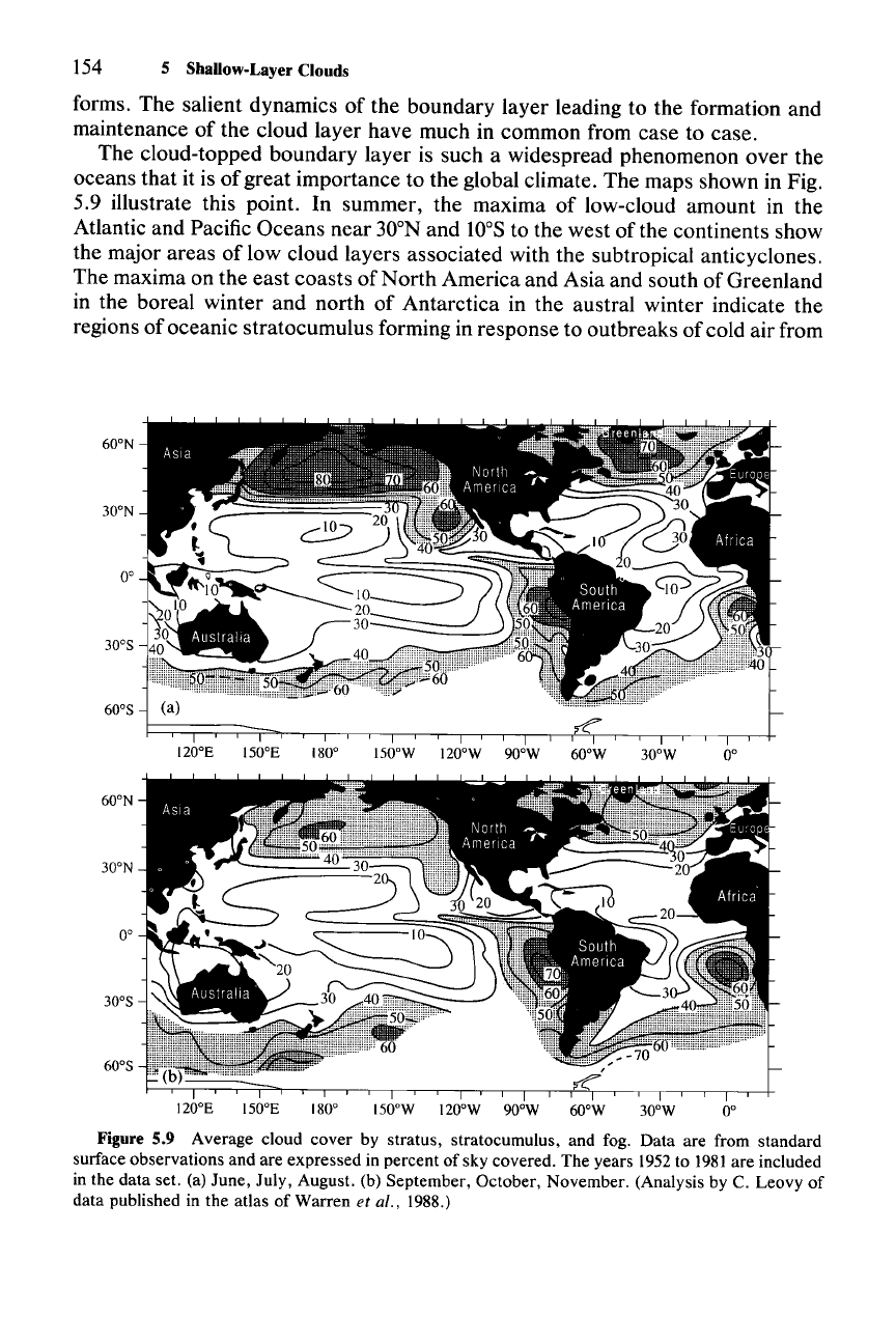
The cloud-topped boundary layer is such a widespread phenomenon over the
oceans that it is of great importance to the global climate. The maps shown in Fig.
5.9 illustrate this point. In summer, the maxima of low-cloud amount in the
Atlantic and Pacific Oceans near 30
0N
and to°S to the west of the continents show
the major areas of low cloud layers associated with the subtropical anticyclones.
The maxima on the east coasts of North America and Asia and south of Greenland
in the boreal winter and north of Antarctica in the austral winter indicate the
regions of oceanic stratocumulus forming in response to outbreaks of cold air from
60
0N
30
0N
0°
300S
600S
120
0E
ISooE
180°
ISOoW
120
0W
90
0
w 60
0W
30
0W
0°
60
0N
30
0N
0°
300S
600S
120
0E
ISooE
180°
ISOoW
120
0W
90
0
w 60
0W
30
0W
0°
Figure 5.9 Average cloud cover by stratus, stratocumulus, and fog. Data are from standard
surface observations and are expressed in percent of sky covered. The years 1952to
1981
are included
in the data set. (a) June, July, August. (b) September, October, November. (Analysis by C. Leovy of
data published in the atlas of Warren et al., 1988.)
5.2 Stratus, Stratocumulus, and Small Cumulus in Boundary Layer Heated from Below
155
the continents. The extent of these regions of oceanic low clouds is so great that it
has been estimated that
"a
mere 4% increase in the area of the globe covered by
low-level stratus clouds would be sufficient to offset the 2-3 K predicted rise in
global temperature due to a doubling of CO
2
•
"123
5.2.2 Cloud-Topped Mixed Layer
5.2.2.1 Conceptual Models
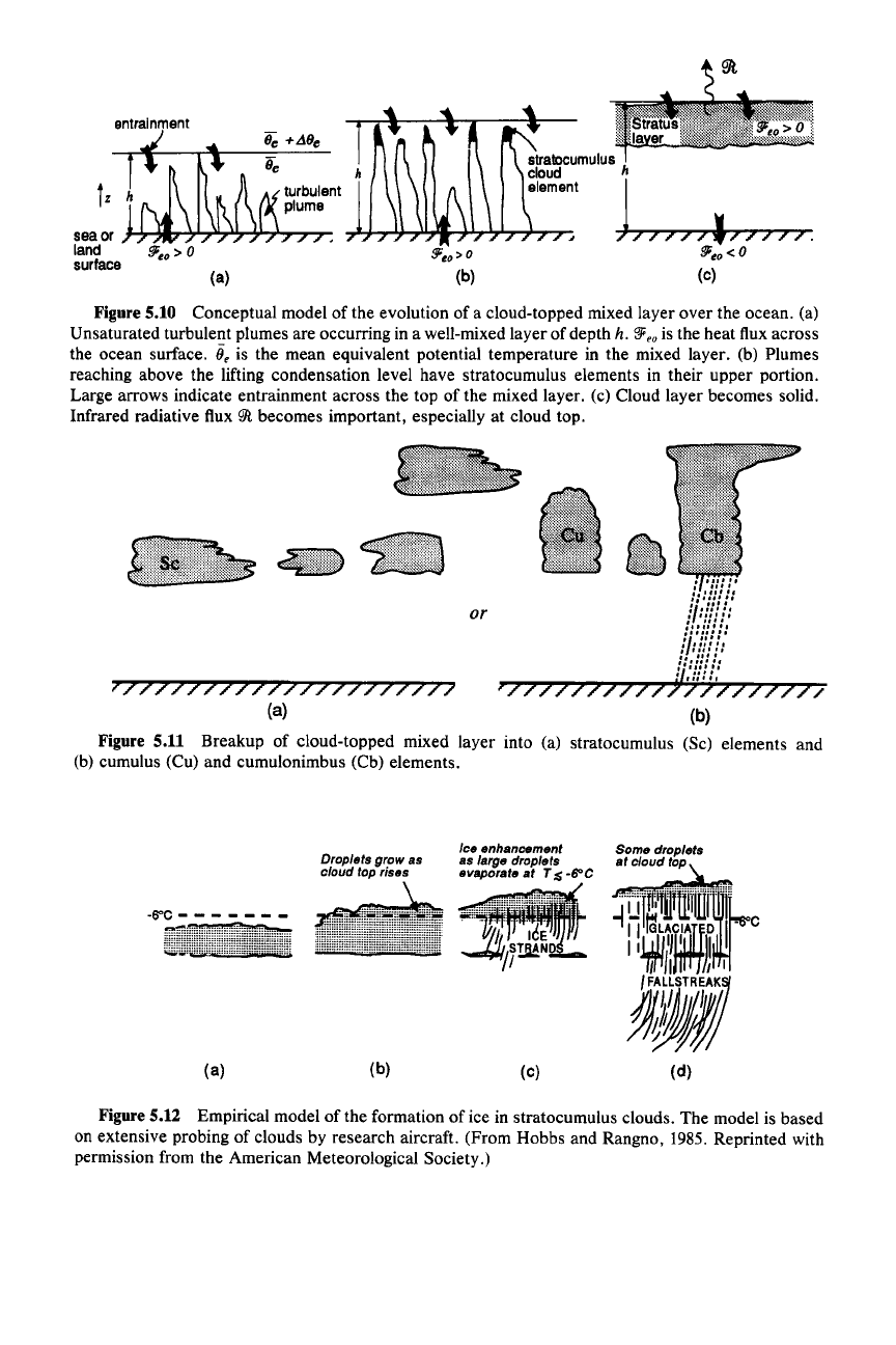
A conceptual model of the development of a cloud-topped mixed layer is given
in Fig. 5.10. We will refer to this illustration throughout the following discussion.
Panel (a) of the figure represents the boundary-layer structure before any cloud
appears. The boundary layer is envisioned to be characterized by a population of
buoyant plumes rising from the warm sea surface.
It
becomes well mixed as a
result of the vigorous upward fluxes of sensible and latent heat. Unlike a radiation
fog layer, in which buoyancy is suppressed by thermodynamic stability, turbulent
kinetic energy is generated strongly by the buoyancy [term
gj
in (2.86)], as well as
by wind shear. The mixing maintains a layer of constant mean equivalent potential
temperature
ii, in a layer of depth h. This mixed layer is bounded above by a layer
of distinctly different
ii"
usually higher. The ii, of the layer aloft is typically
maintained by large-scale subsidence in the lower troposphere. In the case of
subtropical and tropical oceanic stratus and stratocumulus, the subsidence is
associated with the descending branch of the Hadley cell, concentrated in the
eastern sectors of the subtropical oceanic anticyclones. In the case of cloud layers
in polar airstreams off continents in winter, the subsidence occurs in the cold-air
mass behind a front. The change of
ii,across h is represented by
!:J.(J,.
124 The higher
ii, air in the upper layer is entrained by turbulence into the lower layer, thus
diluting the boundary layer but at the same time increasing its depth
h.
As the depth
ofthe
boundary layer increases, the tops
ofthe
turbulent elements
rise above the lifting condensation level, and small cloud elements form (Fig.
5.l0b). As the cloud elements gradually thicken to form a more continuous sheet
of cloud at the top of the mixed layer (Fig. 5.lOc), the physical picture changes
significantly, with radiation taking on an important role. The ocean surface is
shielded by the cloud layer and the turbulent heat flux in the subcloud layer
becomes weak, or even negative. The turbulent energy generation is concentrated
in the cloud layer and is produced by buoyancy as radiative cooling at cloud top
destabilizes the layer of cloud. Turbulence is also generated by wind shear in the
layer [term
C(6
in (2.86)]. The turbulent layer continues to increase in depth as a
result of entrainment.
Finally, the cloud layer breaks up. Observations indicate that when the bound-
ary layer is not extremely unstable, the cloud layer breaks up into stratocumulus
123
This estimate was made by Randall et al. (1984).
124 In this discussion A indicates the difference obtained by subtracting the lower-layer value from
the upper-layer value.
sea or
land
surface
(a)
slralDcumulus
h
cloud
element
J
.,L.J.-,~....,.ll.,Jlh~..J,J~';""""7-:
/ / / / / , 7 7 / / / .
l!Ji.o<O
(c)
Figure5.10 Conceptual model of the evolution of a cloud-topped mixed layer over the ocean. (a)
Unsaturated turbulent plumes are occurring in a well-mixed layer of depth h.
'!F,o
is the heat flux across
the ocean surface.
ii, is the mean equivalent potential temperature in the mixed layer. (b) Plumes
reaching above the lifting condensation level have stratocumulus elements in their upper portion.
Large arrows indicate entrainment across the top of the mixed layer. (c) Cloud layer becomes solid.
Infrared radiative flux
9Jl.
becomes important, especially at cloud top.
(b)
•
III".
,
III.
:://I!
/:
or
fll/iI;:
_"11'"
,.,11'"
IbN!!:
1',/:::.
:i:;;!
I,'
)777777777777777777777
(a)
Figure 5.11 Breakup of cloud-topped mixed layer into (a) stratocumulus (Sc) elements and
(b) cumulus (Cu) and cumulonimbus (Cb) elements.
Droplets grow as
cloud top rises
Ice
enhancement
as large droplets
eVaPorate
at T $ -6"C
(a)
(b)
(c)
(d)
Figure5.12 Empirical model of the formation of ice in stratocumulus clouds. The model is based
on extensive probing of clouds by research aircraft. (From Hobbs and Rangno,
1985. Reprinted with
permission from the American Meteorological Society.)
5.2 Stratus, Stratocumulus, and Small Cumulus in Boundary Layer Heated from Below
157
or small cumulus elements, as suggested by Fig. 5.11a. However, when the
boundary layer is especially unstable, the elements in the breakup phase may take
the form of larger cumulus or even small cumulonimbus (Fig.
5.llb).
The mechanism of the breakup process is not well understood.
It
has been
suggested that it is related to increased entrainment across the top of the mixed
layer. The entrainment might be expected to become large and run out of control
when the
!i.()e between the boundary layer and the layer above is negative and
exceeds a certain large magnitude. According to this idea, a parcel of air entrained
into the mixed layer from above, upon mixing with the cloudy air, would become
denser than its surroundings. Because of the negative buoyancy, the air from aloft
would be rapidly mixed through a portion of the cloud, leaving patchy, dissipating
stratocumulus. Observational studies show, however, that the cloud layer persists
even when the
!i.()e would appear to be sufficiently negative for instability. The
problem appears to be that the potential energy expended in pulling down a tongue
of stable air from above exceeds the energy released in the mixing.
125 The cloud-
layer breakup problem will be discussed further in Sec. 5.2.3.
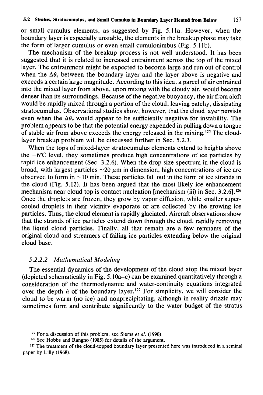
When the tops of mixed-layer stratocumulus elements extend to heights above
the
-6°C
level, they sometimes produce high concentrations of ice particles by
rapid ice enhancement (Sec. 3.2.6). When the drop size spectrum in the cloud is
broad, with largest particles
-20
J.tm
in dimension, high concentrations of ice are
observed to form in
-10
min. These particles fall out in the form of ice strands in
the cloud (Fig. 5.12).
It
has been argued that the most likely ice enhancement
mechanism near cloud top is contact nucleation [mechanism (iii) in Sec.
3.2.6].126
Once the droplets are frozen, they grow by vapor diffusion, while smaller super-
cooled droplets in their vicinity evaporate or are collected by the growing ice
particles. Thus, the cloud element is rapidly glaciated. Aircraft observations show
that the strands of ice particles extend down through the cloud, rapidly removing
the liquid cloud particles. Finally, all that remain are a few remnants of the
original cloud and streamers of falling ice particles extending below the original
cloud base.
5.2.2.2 Mathematical Modeling
The essential dynamics of the development of the cloud atop the mixed layer
(depicted schematically in Fig. 5. lOa-c) can be examined quantitatively through a
consideration of the thermodynamic and water-continuity equations integrated
over the depth
h of the boundary layer.!" For simplicity, we will consider the
cloud to be warm (no ice) and nonprecipitating, although in reality drizzle may
sometimes form and contribute significantly to the water budget of the stratus
125 For a discussion of this problem, see Siems et al. (1990).
126 See Hobbs and Rangno
(1985)
for details of the argument.
127 The treatment of the cloud-topped boundary layer presented here was introduced in a seminal
paper by Lilly (1968).
158 5 Shallow-Layer Clouds
layer. The total water-mixing ratio can be subdivided simply into liquid and vapor
form:
qT =qv + qL (5.18)
where qv is the vapor-mixing ratio and qL is the liquid water-mixing ratio. Since
the clouds are assumed to be nonprecipitating, there is no need to subdivide the
liquid water content further into cloud and precipitation drops, and
qT is a con-
servative variable. As a thermodynamic variable, we use the equivalent potential
temperature
0e s defined by (2.15) and (2.17).
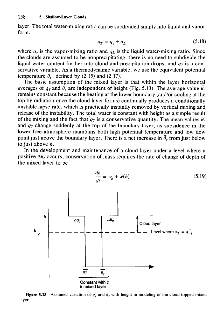
The basic assumption of the mixed layer is that within the layer horizontal
averages of
qt
and
Oe
are independent of height (Fig. 5.13). The average value ii
e
remains constant because the heating at the lower boundary (and/or cooling at the
top by radiation once the cloud layer forms) continually produces a conditionally
unstable lapse rate, which is practically instantly removed by vertical mixing and
release of the instability.
The
total water is constant with height as a simple result
of the mixing and the fact
that'
qr
is a conservative quantity. The mean values ii
e
and
iiT
change suddenly at the top of the boundary layer, as subsidence in the
lower free atmosphere maintains both high potential temperature and low dew
point
just
above the boundary layer. There is a net increase in
e,
from
just
below
to
just
above h.
In the development and maintenance of a cloud layer under a level where a
positive
!i.O
e
occurs, conservation of mass requires the rate of change of depth of
the mixed layer to be
dh
- =
we
+w(h)
dt
(5.19)
h
l-
- -
.1..._---,
t
z
1---------
--[--
L10
e
Cloud layer
- - - - - -
LevelwhereqT
=
qvs
-
...
qT 0e
Constant with z
in mixed layer
Figure 5.13 Assumed variation of
qr
and (J, with height in modeling of the cloud-topped mixed
layer.
