Morris & Fan. Reservoir Sedimentation Handbook
Подождите немного. Документ загружается.

SEDIMENT DEPOSITS IN RESERVOIRS 10.41
the most recent protocol covering both sample collection and laboratory techniques
appropriate for the contaminants of interest and which meet the specific regulatory
requirements of concern.
10.11.3 Surface Dredges
Samples of the sediment on the surface of the deposits may he recovered with a Ponar
dredge (Fig. 8.10e) or similar equipment. This type of equipment will sample only
superficial deposits a few centimeters deep. Surface samples will not be representative of
deposits which exhibit significant layering. This equipment has the important advantage
of ease of use; smaller dredges can easily be managed by hand, although larger ones
require use of a winch. The Ponar dredge can sample both sands and fines, and works
better for sediment grain-size sampling than the lighter Eckman-type dredge. However, a
box-type or core sampler should he used to determine specific weights.
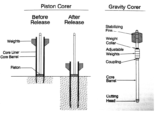
10.11.4 Gravity Corers
Sediment cores are frequently obtained by gravity coring devices consisting of a cutting
head, barrel, thin-wall plastic core liners, weight, and stabilizing fins, as shown in Fig.
10.23. The core barrel has a check valve at the top which allows water to flow out of the
FIGURE 10.23 Piston and gravity corers.
core duri
ng descent, but which closes once the core has penetrated into the sediment and
downward descent is stopped. This creates a vacuum which holds fine sediment in the
core when removed. A core catcher will prevent sandy sediment from falling out of the
barrel upon recovery, but in soft sediment it will reduce sediment capture and should not
be used. After penetration, the corer is raised to the boat, the cutting shoe is removed, a
cap is placed over the exposed end of the core liner, and the core is withdrawn, labeled,

SEDIMENT DEPOSITS IN RESERVOIRS 10.42
and prepared for transport to the laboratory. The recovery depth of a gravity corer is
limited by wall friction inside the coring tube, which can also compress softer sediment
.
10.11.5 Piston Corer
A piston corer consists of an inner piston that fits inside the core liner, an outer core
barrel, drive shoe, and weights (Fig. 10.23). The corer is lowered to the bottom, bringing
the piston into proximity or contact with the sediment surface, at which point the outer
core barrel is released and is driven into the sediment by self-weight while the piston
remains in a fixed position. The downward movement of the core barrel tends to create a
vacuum at the lower face of the piston, which in turn helps draw the sample into the
coring tube and offsetting wall friction, thereby recovering sediment at greater depth than
with a gravity corer.
10.11.6 Other Methods
Conventional drilling equipment mounted on a raft can be used to obtain fully penetrating
cores of sediment deposits, including coarse sediment that will not he penetrated by either
gravity or piston cores. Vibracore techniques have also been used to obtain sediment
cores in lakes and work well in both sandy and soft sediment. A vibracore consists of a
thin-walled tube which is worked through the sediments by vibration of the core barrel to
overcome friction. Some types of vibracore equipment requires scuba divers to operate
equipment on the submerged sediment and float the core to the surface on bags filled
with compressed air.
10.12 CLOSURE
Volumetric surveys have historically been conducted at most reservoirs for the purpose of
passively observing sedimentation and predicting "useful life" of the impoundment. Data
needs expand considerably when the management focus shifts from passive observation,
to active management of the sedimentation process to extend reservoir life or achieve
sustainable use. In addition to information on sediment volumes, it may also be necessary
to determine the active zones of sediment deposition, the grain size distribution, the
presence of potentially toxic substances, cohesive sediment characteristics, and to
undertake detailed monitoring of the sediment inflow and deposition processes which
occur during periods as short as a single storm. Additional data collection effort may also
be required to monitor and minimize downstream impacts of sediment release.
The concepts of deposition patterns and processes presented herein provide only a
general guideline for analyzing sediment behavior at any particular reservoir. Each site
has unique geometry, hydrology, sediment loading, and operational characteristics.
Management and regulatory issues are potentially complex. To adequately characterize
sediment behavior, and to identify effective management alternatives, requires the
collection of sufficient and reliable field data specific to each site. Management
recommendations can be no more reliable than the data upon which they are based.

CHAPTER 11
MODELING OF SEDIMENT TRANSPORT
AND DEPOSITION IN RESERVOIRS
11.1 INTRODUCTION
To manage any system requires a model which predicts future behavior and response to
perturbation. All models are born as mental images and, depending on the situation, they
may grow in complexity to include graphics, desktop calculations, numerical
simulations, and physical scale modeling. Real-world or "prototype" hydrologic
systems are complex, and their behavior is analyzed with models which are greatly
simplified and do not reproduce system behavior exactly. In engineering analysis
this uncertainty is offset by applying informal or formal safety factors, to convert
approximate modeling results into acceptable design parameters.
The principal sediment modeling problems analyzed in reservoirs can be divided into
four major categories.
1. Water and sediment yield from the watershed
2. Rate and pattern of sediment transport, deposition, or scour along the reach above the
dam under different operating rules.
3. Localized patterns of deposition and scour in the vicinity of hydraulic structures
4. Scour, transport, and deposition of sediment in the river below the dam
Sediment yield is typically modeled using a sediment rating curve, erosion modeling, or
related procedures. Techniques for estimating, modeling, and measuring erosion and
sediment yield are discussed in Chaps. 6, 7, and 8. The remaining problem categories are
addressed by using numerical and physical models to simulate hydraulic and sediment
transport behavior in the fluvial system. This chapter briefly outlines hydraulic and
sediment transport modeling approaches, and some of the available modeling tools are
described. Problems such as bank erosion, slope failure, landslide hazard, and wind erosion
from reservoir deposits during drawdown may be important in some individual cases but are not
discussed here.
11.2 MODELING PROTOCOL
Both numerical and physical modeling procedures may be organized into an eight-step
protocol. There is no clear consensus within the modeling community concerning the
MODELING OF SEDIMENT TRANSPORT AND DEPOSITION IN RESERVOIRS 11.2
proper use of the terms calibration, verification, and validation, and the meaning of these
terms should always be interpreted within the context of its usage. The usage presented
below follows that of Anderson et al. (1992).
1. Problem identification. All modeling work begins as a question or a perceived
problem which may be initially defined by management, technical staff, or regulatory
requirements.
2. Conceptual model. Once a problem has been identified, construct a conceptual
model which will define the analytical approach. Formulation of a workable conceptual
model requires one or more site visits, collection of the available historical data,
geomorphic interpretation, and possibly the collection of field data.
Fluvial systems are dynamic and, in addition to obtaining information during site
reconnaissance, it is also important to define the historical events and trends affecting the
geomorphic behavior of the system. The fluvial system may be degrading and coarsening
because of a cutoff of sediment supply by upstream dams or aggregate mining, aggrading
because of erosive land uses or upstream flow diversion, or recovering from a recent
extreme discharge event which scoured the channel. Information on channel changes,
meandering, landslides, and areas of frequent overbank flow should also be ascertained. A
number of data sources may be available to ascertain historical conditions. Streamgage
records can be checked for historical large events and gage shift, which is the gradual
change in the streambed relative to the gage datum. Ensure that any observed gage shift is
caused by a general change in the streambed rather than localized conditions such as bridge
scour. Historical air photos, maps, and reports should be consulted. Old cross-section
surveys for bridges, for example, may provide useful data if the original datum can be
ascertained and the effects of general change in streambed elevation can be distinguished
from localized changes due to bridge scour. Interviews can provide qualitative information.
3. Define Modeling Purpose, Scope, and Methodology. On the basis of the con-
ceptual model, define the specific objectives to be addressed by subsequent modeling
activities.
Problem formulation should identify the study reach, the sediment-related problems
of concern, and the grain size and hydrographs of interest. The study limit should extend
upstream of any anticipated project impacts, and in reservoirs it should extend upstream of
the limit of backwater deposition. Important tributaries influencing sediment inflow or
hydrology should be included. Location of the downstream limit will depend on the
particular study, but should generally extend beyond the area where project impacts are
anticipated to be significant, should include sediment-sensitive areas or structures, and
should include gage stations which may be useful during calibration. A downstream
hydraulic structure or point of bedrock control may constitute a convenient downstream
model boundary. Considering the nature of the problem and the constraints of time, budget,
and data availability, select the modeling approaches and tools to be used. In general,
select the least complicated modeling tools suitable for the problem: do not add
unnecessary complexity to the problem at hand.
4. Model construction and calibration. Using the historical data and
additional field data collection as required, construct and calibrate the model according to
historical conditions. Calibration is the process of adjusting model parameters within a
range of reasonable values to cause the model to accurately reproduce conditions
observed in the prototype system. Many parameters including hydraulic roughness,
geometry, inflowing sediment load, and grain size, as well as transport equations, may
require adjustment during the calibration process.

MODELING OF SEDIMENT TRANSPORT AND DEPOSITION IN RESERVOIRS 11.3
5. Verify existing condition model. The process of ascertaining that the existing
condition model accurately simulates the prototype system by using a dataset indepen-
dent of that used for calibration is termed verification. A model calibrated using one
event should be verified using another independent event or time period. Verification
events should: (1) involve phenomena in the prototype system pertinent to the goals and
objectives of the proposed model study, (2) be continuous and of reasonable duration,
and (3) consist of extreme events only if the simulation of extreme events is to be
addressed in the modeling. In general, the greater the difference between the modeled
conditions and the verification conditions, the greater the uncertainty in the modeling
results (French, 1985). In practice, two independent datasets are frequently unavailable,
making formal model verification impossible.
6. Predictive simulation. Once the model has been calibrated and verified, it can be
run using "future" hydrology and geometry to analyze different structural or opera-
tional alternatives. Models of existing and proposed conditions should normally be
compared by using the same input data series, except when future hydrology needs to
incorporate the effects of future upstream projects and proposed operating rules. If
sediment load is expected to change in the future, because of an upstream dam, for
example, this should also be reflected in the future conditions.
Sensitivity is defined as the change in an output parameter with respect with the
change in an input parameter. For a function of the general form Y
i
=
f(X
i
...X
n
),the coefficient of sensitivity corresponding to a change in the independent
parameter X
i
may be given by:
S
i
Y
i
Y
0
Y
0
100% (11.1)
where S
i
= coefficient of sensitivity expressed in percentage form, Y
0
= value of
dependent parameter for the base condition, and Y
i
= value of dependent parameter
obtained using a changed value of the independent parameter X
i
. The sensitivity of
model results to different input parameters may be determined by changing each input
by the same percentage amount and comparing the percentage changes in the
output parameter. Close attention should be given to any parameter which, when changed
by a small amount, causes a significant change in the result. If results are highly sensitive to
a given input factor, the uncertainty caused by the sensitive parameter may be reduced
by further researching that parameter to determine its value with greater confidence,
or by application of a safety factor (Molinas and Yang, 1991).
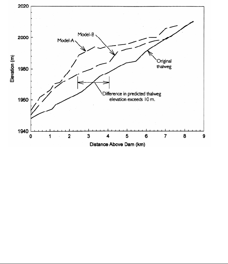
7. Conclusions and recommendations. It is always necessary to interpret model
results within the context of a conceptual model to draw conclusions and make
recommendations. As the amount and quality of calibration data declines, interpretation
will become increasingly dependent on conceptual modeling and engineering judgment.
In the absence of reliable calibration data, if two different models are applied to the same
problem by two different modelers, quite different results may be anticipated, as
illustrated in Fig. 11.1. The uncertainties associated with sediment transport
modeling underscore the importance of conceptual modeling as a guide throughout the
modeling process and as the means of determining which procedures and results are to be
accepted as "realistic" and which are to be discarded as "unreasonable." Reliance on
conceptual modeling and engineering judgment will be reduced, but not eliminated,
if good calibration and verification data are available.
8. Validation. A model is validated when it accurately predicts conditions different
from the calibration conditions, such as the effect of a hydraulic structure. For example, a
model developed to predict long-term impacts may be rerun with actual hydrology
MODELING OF SEDIMENT TRANSPORT AND DEPOSITION IN RESERVOIRS 11.4
FIGURE 11.1 Thalweg profiles above a proposed dam after 41 years of operation with annua
l
flushing, as predicted by two different researchers using two different one-dimensional models. The two
predicted thalwegs differ by more than 10 m in elevation over 20 percent of the modeled reach.
This was due to differences in the input hydrograph time step used in the two models, computational
differences
,
and the lack of data for model calibration.
fol
lowing the first several years of project operation, and compared to field conditions to
determine how well the model is predicting postproject conditions. Ideally the model
would be improved by incorporation of the new data, and its usefulness as a future
management tool would be enhanced. Validation may be considered particularly important
in projects with deficient calibration data, or in situations where postproject conditions
depart significantly from calibration conditions.
11.3 CONCEPTUAL MODELING
Conceptual modeling involves mental visualization of the fluvial system and
perturbations thereof. Conceptualization may be supported by graphics, field data, and
desktop calculations. The formulation of accurate conceptual models lies at the
foundation of all engineering analysis and is the basis for engineering judgment.
Conceptual modeling determines which potential problems are insignificant and may
be ignored, which are to be analyzed in more detail, and which analytical approach
and assumptions are to be used in subsequent analysis. Numerical and physical
modeling supplement rather than replace conceptual modeling, which continues to
be the basis for interpreting conflicting or unexpected results encountered during
modeling, and for converting modeling results into specific design recommen-
dations. Conceptual modeling provides the ultimate "reality check" against which all
other modeling results must be compared.
In projects having a generous budget for data collection and modeling, extensive
calibration data may be available and reliance on conceptual modeling may be
reduced. More frequently, projects have tightly constrained budgets and time frames,
MODELING OF SEDIMENT TRANSPORT AND DEPOSITION IN RESERVOIRS 11.5
the available calibration dataset is extremely limited, and it is desired to analyze
processes which can be simulated only approximately by current modeling tools. Under
these conditions, results can depend heavily on conceptual modeling.
Accurate conceptual modeling proceeds from three types of knowledge: fundamental
understanding of fluvial and sediment behavior, experience from other sites, and site-spe-
cific information. Fundamental concepts of hydraulics and sediment transport may be
learned through both formal and individual study. The interpretive skills of fluvial geomor-
phology are particularly relevant to the interpretation of natural environments and development
of conceptual and semiquantitative models of the fluvial systems. Experience is gained through
one's own practice complemented by a review of case studies and site visits.
The site visit is a singularly important component of all modeling work. The follow-
ing procedures can improve the information obtained during site visits.
Timing. The initial site visit should be undertaken at the very beginning of a project,
before formulating the problem and selecting the modeling tools. In rivers, the site
visit should be timed to coincide with low water when the bars are exposed and may
be sampled. An existing seasonally emptied reservoir should be visited during
maximum drawdown to better observe geometry and deposition patterns.
Mapping and aerial photography. The combination of mapping and aerial pho-
tography provide the initial basis for understanding the fluvial system. Both
should be reviewed prior to a site visit and taken to the field. An overflight of the
project area is highly recommended. Oblique 35-mm photographs from an aircraft
shot in an overlapping sequence can be a highly useful visualization tool, especially
when combined with ground photography. For example, see the photos reproduced in
Fig. 10.7.
Ground Photography. Always take more film and photographs than will be needed,
and photograph everything. Overlapping panorama-type photos can be very useful.
Ground photography should also be used to illustrate riverbed characteristics, and in
gravel-bed systems the photographic technique outlined by Adams (1979) and described
in Sec. 8.8.10 can also provide quantitative grain size information for the armor layer.
Sampling. Points of bed material sampling should be selected by the modeler.
However, in some cases the modeler will not be directly involved in the
collection and analysis of samples, but may be supplied with grain size curves based
on sampling performed by others. Sample collection by the modeler during site
visits is highly recommended, even if not part of the formal sampling program.
The primary purpose of this sampling is to help the modeler observe bed conditions
and grain size variations during the site visit. These observations will be more
focused if the modeler attempts to collect representative samples, compared to a
walkover or "windshield" reconnaissance. Informal samples collected by
modelers need not be large, and for sands need not exceed 30 cm
3
in size (about
the size of a 35 mm-film canister). The modeler's samples should be analyzed
for grain size distribution and compared with the grain size curves provided by
others to better correlate field conditions to the size distribution curves, and check for
possible anomalies in the supplied data.
Interviews. Residents, fishermen, utility workers, and others who have many years of
familiarity with the system should be interviewed. They can provide valuable
information on trends or unusual events that might otherwise be overlooked.
In summary, field time should be used to collect as much information as possible about the
system, from every available source. Visit as many sites along the rivers as possible, not
just bridges. Where possible, travel the study reach by boat. Collection of represen-
tative field information is the single most important activity leading to a reasonably
accurate conceptual model of the prototype system.

MODELING OF SEDIMENT TRANSPORT AND DEPOSITION IN RESERVOIRS 11.6
11.4 NUMERICAL MODELING
Numerical sediment transport models are available to simulate flows in one, two, and
three dimensions. However, most modeling is performed with one-dimensional models,
which are far more robust than their two- and three-dimensional counterparts. Molinas
and Yang (1986) noted that two- and three-dimensional models require extensive amounts
of computer time and calibration data, and may not be desirable for solving engineering
problems with limited data and resources when the problem can be analyzed within the
context of a one-dimensional model. Because river systems and most reservoirs have
highly enlongated geometry, the assumption of one-dimensional flow is appropriate for the
analysis of many types of sediment problems. The following discussion reflects the
capabilities and requirements of one-dimensional models.
One-dimensional mathematical models are used to analyze sediment transport along
long reaches of rivers or in reservoirs where essential transport processes can be simu-
lated with a one-dimensional flow field. They are applied to problems such as sediment
accumulation in reservoirs as a function of the operating regime, sediment pass-through, and
scour below dams. Numerical models have several important advantages over physical
models: lower cost, ease of re-running to simulate a variety of different conditions, ability
to simulate some types of problems numerically that are unsuitable for physical modeling
because of the scaling laws involved (e.g., sediment cohesion), portability, and
reproducibility. Mathematical models may be copied onto magnetic or optical media,
transported and reproduced on compatible computers anywhere worldwide, and stored for
any length of time and then re-run.
The initial geometry of the model is established by using river cross sections and
specifying the width, depth, and grain size distribution of the movable bed. The grain size
and load of inflowing sediment at the upstream limit of the model must also be defined.
Movable bed numerical models solve hydraulic and sediment transport equations
iteratively through a series of time steps. In one-dimensional models, the hydraulic
parameters are computed at the start of each time step, typically using the assumption of
steady flow, and calculations proceed in the upstream direction according to the standard
step method. The resulting hydraulic parameters are then used to solve sediment transport
equations to determine sediment transport capacity along each reach during each time
step. This transport capacity is then compared to the inflowing load and the bed condition to
determine the amount and grain size of the sediment that is either deposited or scoured. A
sediment balance is computed for each reach starting at the upstream limit of the model and
proceeding downstream. The movable bed geometry is adjusted in accordance with net
sediment scour or deposition along each reach, and the new bed geometry is then used
in the hydraulic computations for the subsequent time step. These models usually
incorporate a sediment bed consisting of multiple layers, allowing the process of armor
formation to be simulated.
Most of the commonly used numerical sediment transport models were originally
developed for the analysis of movable bed rivers having coarse sediments and employ
sediment transport equations developed from flume and river data. In contrast, reservoir
problems may involve the analysis of grain sizes ranging from cobbles in the delta area to
clays near the dam. The silts and clays which normally behave as wash load in most
rivers, and which are ignored in many river sedimentation models, often constitute the
majority of the total sediment load in a reservoir. Unlike riverine systems, reservoirs are
normally depositional environments. However, during drawdown, reservoirs may
experience retrogressive erosion, hyperconcentrated flow, and modification of deposit
erodibility by sediment cohesion. A relatively small percentage of cohesive material can
MODELING OF SEDIMENT TRANSPORT AND DEPOSITION IN RESERVOIRS 11.7
significantly decrease the erosion rates for coarse sediment, as discussed in the Sefid-Rud
case study (Chap. 23). These phenomena are atypical of river environments and can be
simulated only in a very approximate manner by current numerical models.
Present numerical models are not well-suited to modeling sediment transport in complex
curvilinear or three-dimensional flow fields, complex flows around structures, transport
phenomena associated with turbid density currents, and problems involving river
morphology. Numerical modeling of sedimentation problems only approximates the
behavior of the prototype and does not substitute for professional experience and
judgment, as model results typically require considerable interpretation. Mathematical
models have also historically been limited in their ability to demonstrate results visually
compared to physical models, although postprocessors that provide tools such as
contour mapping, animation, and particle-tracing greatly enhance visualization, when
two and three-dimensional models are used.
11.5 CONSTRUCTION AND CALIBRATION
OF NUMERICAL MODELS
Several aspects of preparing and calibrating one-dimensional models are outlined in this
section. Detailed information on the application of specific numerical models is
available from user manuals, model vendors, and short courses. The site visit and
related activities discussed under conceptual modeling should be undertaken before
initiating model development.
11.5.1 Hydrology
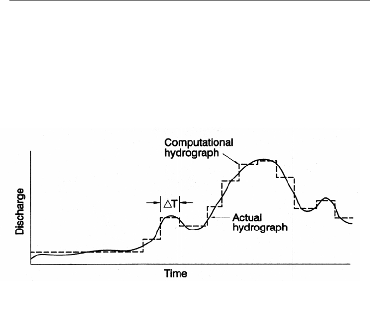
In most one-dimensional models, the inflowing hydrograph is specified as a series of
constant-discharge intervals, as illustrated in Fig. 11.2. Because sediment transport is
FIGURE 11.2 Stepwise approximation of a continuous discharge time series for inpu
t
into a numerical sediment transport model.
conce
ntrated in periods of higher discharge, low flows may be simulated by a long
period of constant discharge, or flows below a threshold considered to have negligible
effect on sediment transport may be simply ignored. Proposed condition hydrology may be
modified by a change in operating rules which influences the flow-duration characteris-
tics of the stream.
MODELING OF SEDIMENT TRANSPORT AND DEPOSITION IN RESERVOIRS 11.8
11.5.2 Geometry
To represent the behavior of a fluvial system in a one-dimensional model requires that
the system geometry be specified in a manner that reproduces the essential
prototype hydraulic behavior. Model geometry must be configured to simulate a one-
dimensional flow path followed by sediment and water moving toward the dam, and
cross-section locations should be selected to reflect reach-averaged hydraulic
conditions.
There is no rule of thumb for the distance between cross sections, and, depending on the
study purpose, cross sections may be located several kilometers apart or only a single
river width apart. The key objective is to reproduce the hydraulic characteristics of the
reach. Cross-section geometry at a specific point may require adjustments to better
simulate the hydraulic characteristics of the reach. Hydraulically ineffective areas of the
reservoir lying outside the main flow path should be eliminated from the model, as illustrated
in Fig. 11.3. Similarly, surveyed sections in rivers may be truncated to eliminate areas of
ineffective flow caused by obstructions (Fig. 11.4). Whether a given discharge is
contained within the movable channel boundary or can overflow onto the floodplain can
have a significant impact on sediment transport, and overbank elevations may be adjusted to
reflect values representative of the reach when survey lines intersect localized depressions
in the floodplain.
In addition to defining the initial hydraulic geometry of the cross section, it is also
necessary to define the width and depth of the movable bed. Field inspection
should give particular emphasis to the identification of bedrock or clay lenses that may
limit the scour depth and sediment supply during large events. Horizontal limits of the
movable bed should be based on field inspection and indicators such as vegetation. A
generalized idea of the sensitivity of one-dimensional sediment transport models to
input parameters is given in Table 11.1.
11.5.3 Selection of Transport Equation
The use of different bed material transport equations in a numerical model can
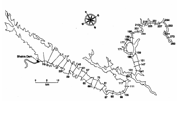
produce significant differences in the simulation results. For example, Gist et al. (1996)
FIGURE 11.3 Bhakra dam, India, illustrating the layout of the cross sections
used to simulate sedimentation processes by a one-dimentional mathematical
model (after Mandnwrrnft et al., 1992)