Morris & Fan. Reservoir Sedimentation Handbook
Подождите немного. Документ загружается.

SEDIMENT DEPOSITS IN RESERVOIRS 10.11
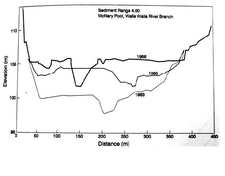
FIGURE 10.9 Aggradation and lateral channel movement in the area of delta deposition
along the impounded Walla Walla River, tributary to McNary Dam on the Colum
b
ia Rive
r
(courtesy U.S. Army Corps of Engineers, Walla Walla District).
The timewise aggradation within the delta reach of the impounded Walla Walla River, a
tributary to the Columbia, is illustrated in Fig. 10.9.
10.3.2 Slope of Delta Deposits
Knowledge of the slope of delta deposits can be used to predict the extent of delta deposition
and consequent rise in flood levels above the reservoir pool. Initially the delta slope will
extend upstream from the pivot point defined as the intersection of the topset and foreset beds
(Fig. 10.1). In a fully sediment reservoir or debris basin, when the delta deposits extend to the
dam, the spillway will define the pivot point. The delta slope is a primary factor determining
both the length of upstream aggradation of delta deposits and the volume of sediment that
can be stored, and because delta deposits extend upstream at some slope greater than
horizontal, a fully sedimented dam can store much more sediment than water. This is an
important consideration in estimating the amount of sediment than can be trapped in debris
basins, including heavily sedimented reservoirs that may be relied on to reduce sediment
yield at downstream reservoirs.
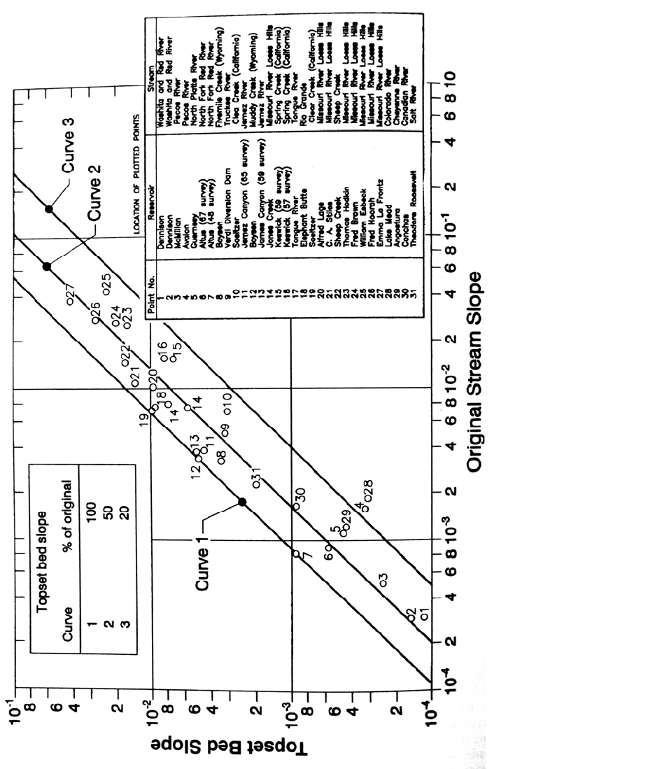
Data from reservoirs in the United States has shown that the slopes of delta deposits range
from a relatively flat 20 percent of the original stream slope to nearly 100 percent of the
original stream slope (Fig. 10.10). In many reservoirs the top slope of the delta will be
about half of the original streambed slope (Borland, 1971), and this is often used as a rule
of thumb. However, because a wide range of delta slopes can occur under different
conditions, the U.S. Army Corps of Engineers (1989) specifically warns against using
rule of thumb values for estimating delta slopes. Numerical modeling is recommended as the
most effective method for predicting the ultimate topset slope. Empirical relationships can be
useful for estimating slope only when applied to reservoirs having geomorphic and operating
conditions similar to the sites used in the empirical dataset.
SEDIMENT DEPOSITS IN RESERVOIRS 10.12
FIGURE 10.10 Topset slope versus original stream slope from existing reservoirs (Strand and Pemberton, 1987).

SEDIMENT DEPOSITS IN RESERVOIRS 10.13
10.3.3 Foreset Slope
Foreset slope is often estimated from empirical relations, but this method is not
particularly accurate unless the empirical relationship is derived from similar reservoirs.
For example, Strand and Pemberton (1987) report that the average of foreset slopes
observed in Bureau of Reclamation reservoir resurveys is 6.5 times the topset slope, but some
reservoirs exhibit a foreset slope an order of magnitude greater than this. For example, the
foreset slope of the Lake Mead delta is 100 times the topset slope. In contrast, reservoirs on
rivers in China with a heavy silt load have foreset slopes about 1.6 times the original river
bed slope (Wuhan College of Hydropower, 1982). Generally, deltas composed of coarse
granular material (sand, gravel) will have a steep foreset slope, whereas deltas containing
fine-grained material will have much lower slopes. Similar patterns are observed in river
deltas discharging to the ocean. Sandy sediment that accumulates at the mouth of Rio
Senegal has a subaqueous slope of about S = 0.017, nearly 30 times steeper than the fine-
grained Mississippi delta with S = 0.0007 (Coleman, 1982).
10.4 MEASUREMENT OF DEPOSITION RATE
The rate and pattern of reservoir sedimentation is normally documented by comparison of
periodic surveys performed by either the range or contour method. However, alternative
methods for estimating volume change or deposition rate may be useful or necessary in
some circumstances.
10.4.1 Sediment Mass Balance
The amount of sediment deposited in a reservoir can be estimated from the difference
between fluvial sediment inflow and discharge over either a short (single-event) or a long
time frame. This technique is essential for obtaining detailed information on the process of
sediment delivery and trapping in the reservoir, and for evaluating and monitoring the
effectiveness of different sediment management techniques. However, reliable long-term
results are difficult to obtain, and a mass balance should not be relied on as the sole means
of estimating the rate of sediment accumulation and storage loss. A sediment mass balance
should always be checked with reservoir surveys.
10.4.2 Horizon Tracing Using
137
Cesium
The rate of sediment accumulation can be determined by measuring the depth of deposition
above an identifiable and datable horizon. One such horizon is the layer of radioactive
137
cesium which was deposited worldwide by atmospheric nuclear testing. The
137
cesium isotope does not occur naturally; it first appeared in measurable amounts
in 1954 and increased rapidly as a result of fallout from Russian nuclear tests from 1962
through 1964. Because it remains tightly adsorbed into the clay lattice structure in freshwater
environments,
137
cesium remains in the top layer of soil and can be used to trace surface
sediment as it is eroded and redeposited.
137
Cesiurn emits gamma radiation which can be
measured directly in samples, and with a 30-year half-life, it will be possible to measure
137
cesium content of soils and sediment deposits for some years to come. Radioactive
cesium is not found in sediments deposited prior to 1954, and peak values occur around
1964, producing two datable layers in the profile. Because the absolute magnitude of
137
cesium counts will vary from one site to another, and as a function of clay content in the
SEDIMENT DEPOSITS IN RESERVOIRS 10.14
deposits, the method requires that older sediments be deposited below the datable layer to
detect the horizon created by the relative increase in activity.
The procedure for dating reservoir sediments based on
137
cesium has been described
by McHenry and Ritchie (1980). In reservoirs, an 8-cm-diameter sediment core is
extracted and sectioned into increments of 5 to 10 cm. Composites of each depth increment
are made if multiple cores are required to obtain adequate sample material. The samples are
dried and gamma emissions are counted. Once the depth of the datable layer is located, the
rate of sediment accumulation can be determined from the depth to the bottom of the cesium-
contaminated layer. The
137
cesium technique can also measure the recent rate of sediment
accumulation in natural lakes which may not otherwise have a datable horizon, unlike
reservoirs which have an identifiable preimpoundment bottom. For example,
137
cesium has
been used to measure modern sedimentation rates in natural lakes along the Mississippi
River (Ritchie et al., 1986; McIntyre et al., 1986).
Cesium dating has also been used to monitor soil erosion and to date surface deposits,
as reviewed by Walling and Quine (1992).
137
Cesium dating has been used in combination
with erosion pins to study sediment movement on hill slopes (Saynor et al., 1994), and to
determine rates of valley and channel sedimentation (Whitelock and Loughran, 1994).
134
Cesium, which was not present in bomb fallout, was released by the Chernobyl accident in
1986 and has been used to investigate the rate of floodplain deposition in Europe (Froehlich
and Walling, 1994).
10.4.3 Sub-bottom Profiling
A sub-bottom profiler is a sonic depth measurement system which combines a high-frequency
signal in the 200-kHz range which reflects off a soft bottom and a lower-frequency signal
in the 5- to 24-kHz range which will penetrate deeper and reflect from a denser horizon
consisting of original soil or rock. Under favorable conditions, sediment thickness exceeding 10
m can be measured. The ability to obtain useful data from sub-bottom profiling is site-
specific. In particular, sonic energy is strongly reflected from water-gas interfaces, and
the presence of methane gas bubbles produced by the anaerobic decomposition of organic
material in the sediment can make it impossible to obtain readings from the original bottom at
some sites (as in the Cachi case study). Where conditions permit its use, this technique can
rapidly map sediment thickness without knowledge of the original bottom topography.
10.4.4 Spud Surveys
The spud survey method is a simple manual technique for measuring the total depth of
sediment accumulation. Developed in 1934 and described by Eakin and Brown (1939), the
spud method can be used to determine the location of the original bottom and the
thickness of sediment deposits, without prior knowledge of the original bottom contour.
Because sonic sub-bottom profiles are confounded by gas layers that may occur in sediment
deposits, the spud may be used to measure sediment depth in situations where sonic techniques
fail. As a limitation, the spud method works only in soft sediments, generally consisting of fines
not exposed to air drying and with a maximum thickness of about 4 m.
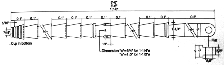
A spud is a case-hardened steel rod about 2 to 3 m long and about 3 to 4 cm (1
1
/4 to
1% in) in diameter into which outward-tapering grooves have been machined at regular
intervals (Fig. 10.11). The Natural Resource Conservation Service (no date)
recommends a sectioned spud that can be assembled up to 5 m in total length to facilitate
transport and also notes that a reinforcing bar having a rough coating of concrete to
facilitate silt retention may be used.
SEDIMENT DEPOSITS IN RESERVOIRS 10.15
FIGURE 10.11 Configuration of spud to determine the thickness of soft sediment deposits
(Eakin andBrown, 1939).
The spud is cast or allowed to fall vertically through the water with force sufficient to
penetrate the deposited sediment and into the underlying original soil material, or it is
driven by hand in water too shallow for a boat. After the spud depth (spud plus line length)
is noted, it is lifted slowly so as not to wash out the sediment captured in the grooves, and it
is examined to determine the depth to the pre-impoundment bottom based on a change in
texture, color, presence of roots, etc. The depth to the top of the sediment deposits is
simultaneously determined by using a sounding weight, and deposit thickness is
determined by subtraction. Under favorable conditions, a spud can penetrate sediment a
meter or so deeper than its total length. This method is most applicable to water depths less
than 30 m, but by coating the bar with heavy grease prior to each measurement to minimize
sample washout during recovery, the spud has been used successfully in water up to 60 m
in depth (Castle, 1963). The accuracy of the method depends on the operator's experience and
skill in determining the depth to the original bottom on the basis of the samples collected in the
grooves, but this skill can be rapidly learned (Ritchie and Henry, 1985). In dry reservoirs
sediment thickness can be determined by angering.
10.4.5 Sedimentation Plates
Flat plates can be placed at distinct points on the bottom of a reservoir, and the deposit
depth over the plates can be subsequently measured at intervals. Flat plates have the
advantage over sediment traps in that they do not pose any type of obstruction to the horizontal
flow of water or concentrated muds near the bed. In areas where the rate of sediment
accumulation is low, on the order of centimeters per year or less, it may be difficult to
estimate sedimentation rates from small differences in the surveyed topography across an
undulating bed. Sedimentation plates provide a stable datum against which small amounts
of sedimentation can be measured on a repeated basis. The plates can be located after they
have become buried by sediment by means of wands or posts, electronic surveys, global
positioning system, or metal detectors. A magnet can be buried with nonmetallic plates to
aid location by a detection device. Sedimentation plates are best suited for use in areas of
reservoirs which are periodically drawn down, allowing plates to be set out and remeasured
on the dry reservoir bed. As a disadvantage, the setting out and recovery of data from
sedimentation plates is labor-intensive. They can provide a general picture of sedimentation
rates, but if used should supplement rather than replace reservoir surveys.

SEDIMENT DEPOSITS IN RESERVOIRS 10.16
10.5 RESERVOIR CAPACITY SURVEYS
Repeated reservoir capacity surveys are used to determine the total volume occupied by
sediment, the sedimentation pattern, and the shift in the stage-area and stage-storage curves.
By converting to sediment mass on the basis of estimated or measured bulk density, and
correcting for trap efficiency, the sediment yield from the watershed can be computed.
10.5.1 Types of Surveys
Reservoir surveys are classified as either contour surveys or range surveys. Contour
surveys use more complete topographic or bathymetric information to prepare a contour
map of the reservoir. They are the most accurate technique for determining volume and also
provide the most complete information on sediment distribution. Recent advances in
automated survey techniques now make hydrographic contour surveying very economical in
smaller and midsize reservoirs, which may require only a few days of field time using
automated depth measurement and positioning systems to perform the tightly spaced data-
collection traverses required by contouring software.
The range method uses a series of permanent range or cross-section lines across the
reservoir which are resurveyed at intervals and used to compute the intersurvey volume
change in each reach by geometric formulas. Hydrographic survey techniques are used for
submerged areas, and standard land surveying or photogrammetric techniques are used
above the water level. Range surveys are faster and more economical to perform than
contour surveys because field data requirements are greatly reduced compared to contour
surveys. They have historically been the most commonly employed technique to monitor
sedimentation, but are increasingly being supplanted by automated contour surveying
methods. Range surveys are well-suited for tracking changes in storage as a result of
sedimentation, with a minimum of field time. Best results are obtained if contour survey
methods are used to accurately determine the volume bounded by adjacent range lines, and
range end areas are then correlated to this volume. The range method is subsequently used to
track changes in storage based on the changes in range geometry. The constant factor and
width adjustment methods are based on this principle.
10.5.2 Survey Intervals
The reservoir survey interval should be based on individual site characteristics. At
reservoirs losing capacity very slowly, a survey interval on the order of 20 years or even
longer may be adequate. By contrast, at important sites which are losing capacity
rapidly, or where the impact of sediment management is being evaluated, a survey interval
as short as 2 or 3 years might be used. Deposits should be surveyed and sampled after a
major flood which has a significant impact on the reservoir or which may provide
information for subsequent model calibration, as described in the Feather River case study
(Chap. 22). A reservoir should also be surveyed as soon as a new reservoir is closed
upstream to provide a baseline for computation of the new sedimentation rate from the
reduced area of uncontrolled drainage.
Sedimentation rate is computed as the difference between volume measurements from
two surveys. The minimum survey interval depends on the precision of the survey
technique and the rate and pattern of storage loss. For instance, if a survey technique
incorporates an error on the order of 2 percent of the total reservoir volume, and if the
reservoir is losing capacity at 0.25 percent per year. a 4-year survey interval may be too
SEDIMENT DEPOSITS IN RESERVOIRS 10.17
short to produce reliable information unless most sediment inflow is focused into a small
portion of the impoundment. The Cachí case study describes the unusual situation in which a
1-year reservoir survey interval was used. To produce the required level of precision for
comparing the two surveys, the change in depth (i.e., change in sediment thickness) was
computed for only those points in the two bathymetric datasets which were considered to be
exactly coincident in the horizontal plane. Also, at Cachí most sediment deposition was
focused along the flushing channel, producing localized deposition depths exceeding 1 m
between the two survey dates.
10.5.3 Survey Techniques
A bathymetric or hydrographic survey is performed with sonar operating in the 200-kHz
range from a moving boat. Current systems typically include real-time positioning systems,
data logging onto a portable computer, and postprocessing software for the preparation of
digital maps.
If a reservoir is emptied or substantially drawn down, photogrammetric techniques or
airborne laser can be used to map the above-water contours.
In a reservoir subjected to a wide range in stage or which is regularly emptied, aerial
photography can be repeated at different water levels, measuring the pool surface area at
each level to generate the elevation-area relationship for the reservoir. In large reservoirs, the
pool area at different water levels can be determined from satellite images. When the
inflow and discharge from a reservoir is accurately measured during drawdown, a stage-
volume relationship may be constructed from the net volume of water released and the
change in water level.
10.5.4 Survey Errors
All techniques for estimating reservoir volume incorporate errors. In sedimentation
surveys, the objective is to accurately measure the difference between successive surveys.
This makes computation of sedimentation rate extremely sensitive to small errors in
volume estimates, especially when the volume changes are relatively small because of a
short intersurvey period or low sedimentation rate, or when reservoirs are new and have not
yet lost a significant percentage of their total volume. Errors of only a few percent in the
total volume estimate can produce errors of several tens of percent in the computed
sedimentation rate. With the range method, volume estimates can vary as much as 10
percent in small reservoirs, depending on the computational method, quantity, and
orientation of ranges (Heinemann and Dvorak, 1963). Volumetric differences up to 30
percent along individual reaches have been reported by Murthy (1977), depending on the
range computational procedure used. When range methods are used it is essential that range
tracks be resurveyed as accurately as possible so that the profile changes represent
sediment deposition rather than a meandering survey line. It may not be possible to exactly
relocate range lines, and it will then be impossible to exactly reconstruct the original
survey lines, resulting in resurveyed ranges having significantly different top widths at the
"same" station. Identical computational methods must be used for each survey.
When the reservoir survey technique is to be changed (e.g., from range to contour),
the new survey data should be used to compute the volume by both the old and the new
techniques to determine the bias between the two methods. This bias can then be used to
adjust volumetric estimates prepared at different times in the reservoir life, producing a
consistent volumetric time series for estimating sedimentation rate. Changes in the pool level

SEDIMENT DEPOSITS IN RESERVOIRS 10.18
due to gate modifications should be adequately documented, and, when they occur the
entire data series of reservoir volumes should be retabulated for a consistent pool level. In
reservoirs with poorly consolidated sediments, the bottom may not be distinct, and
submerged forests or other vegetation will also complicate location of the true bottom.
Fathometers must be calibrated properly to compensate for the effects temperature
stratification and depth of transducer submergence.
10.5.5 Reporting
The usefulness of sedimentation studies to workers attempting to manage sedimentation
depends heavily on the completeness of the reporting. Recommended contents for a sedimentation
report are outlined by Blanton (1982):
General information on the dam, reservoir, and drainage basin.
1. Information on all surveys at the reservoir, past and present.
2. Description of the survey and sampling techniques for the present survey and of special
techniques employed.
3. Reservoir map showing all range line locations.
4. Description of all major survey controls, together with a table listing horizontal and
vertical control information.
5. A graph showing the reservoir stage fluctuation or stage duration curve.
6. Profiles of all reservoir and below-dam degradation ranges showing the latest survey
superimposed on the original profile, and in some instances plots from selected prior
surveys.
7. Graphs of sediment distribution in longitudinal profile, in percent depth versus percent
sediment volume and in percent depth versus percent distance from the dam.
8. Data in tabular and graphic form describing sediment densities and particle sizes and a
map of sampling sites.
9. Revised area and capacity tables and curves resulting from the new survey.
10. Any data on sediment inflow and outflow which may be available for estimating trap
efficiency.
The inclusion of these data will greatly facilitate understanding of the sedimentation
process. As appropriate, summary data should also be submitted to regional or national
databases.
10.6 CONTOUR SURVEYS
10.6.1 Contour Survey Methods
The preferred method for performing reservoir contour surveys is using automated
hydrographic surveying equipment. Description of a reservoir contour survey by automated
hydrographic survey techniques is given by Webb and Górnez-Gómez (1996). Surveying
technology is advancing rapidly, and a variety of computerized hydrographic survey
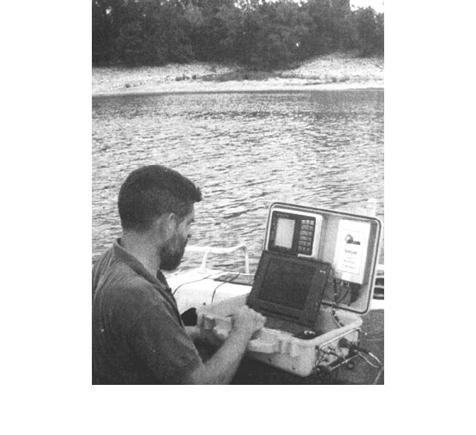
systems are available commercially, such as the portable system shown in Fig. 10.12. A
typical system consists of a real-time positioning system such as the differential Global
SEDIMENT DEPOSITS IN RESERVOIRS 10.19
FIGURE 10.12 Use of portable automated hydrographic survey equipment (courtesy o
f
Specialty Devices. Inc.).
Po
sitioning System (GPS) or microwave equipment (range-range or range- azimuth) and
a single-beam fathometer operating in the 200-kHz range, which together define the
absolute x, y, z coordinates of the reservoir bottom during traverses. Typical accuracies
are about 0.1 m in depth and from several centimeters to several meters in the
horizontal plane, depending on the positioning system used. The data file is post-
processed to generate range profiles or a contour plot of the entire reservoir. For the
preparation of a contour map, the network of traverses should be much denser than in
traditional range survey methods, and manual manipulation should be anticipated to
create the final contour map. Closely spaced traverses will minimize interpolation
problems during postprocessing, since contouring algorithms perform better as data
density increases. In general, for contouring the distance between traverses should be
significantly less than the shore-to-shore traverse length to minimize interpolation
errors.
Automated survey systems have several important advantages over conventional
methods. Large amounts of survey data can be collected rapidly and economically and to
a high level of accuracy. Reliance on range markers is eliminated by navigational
systems referenced to an absolute coordinate system. Preplanned track lines can be
specified, and the system will display real-time navigational instructions to the pilot,
greatly facilitating the accurate repositioning of lines when ranges are to be
resurveyed. All position and depth data are continuously recorded into a file which can
subsequently be postprocessed to plot survey results and automate tedious volume
computations. By overlaying bathymetric maps from different survey dates, maps of net
depth of deposition or scour can be generated. The hydrographic survey should be
performed when the reservoir is at a high water level. Areas above water must be

SEDIMENT DEPOSITS IN RESERVOIRS 10.20
surveyed by either traditional or photogrammetric methods and merged with the
hydrographic survey data.
10.6.2 Volume Computations from Contour Data
By using the stage-area curve method, the area of each contour within the reservoir pool
is determined and used to plot the stage-area curve. The volume between any two
adjacent elevations can be determined by integrating the area under the stage-area
curve with a planimeter or by trapezoidal approximation, and the resulting volumes
summed to create a stage-storage curve.
For computing volumes from contour data, two methods are available for determining
the volume between each successive pair of contour lines. The average contour area
method should be used between range lines, which produces contour surface areas that
increase only as a function of reservoir width, while the reach length is constant for all
elevations. The equation is
Volume =
H
(
A
1
A
2
)
2
(10.1)
where H = elevation difference between adjacent contour lines and A
1
and A
2
are the
surface areas enclosed by each contour line.
When surface area increases as a function of two dimensions, length and width, a
more accurate estimate of the enclosed volume is obtained by the modified prismoidal
method in which
Volume =
H[A
1
(A
1
A
2
)
1/2
A
2
]
3
(10.2)
where the symbols are the same as before. Additional computational algorithms are
provided in commercial software packages for use with digital mapping.
10.7 RANGE SURVEYS
The range method has traditionally been the most widely used method to measure reservoir
sedimentation. It provides the means to efficiently track sediment accumulation with a
minimum of field data. When sediment thickness is known along range lines, the range
methods can also be used to compute sediment volumes directly. Methods of computing
reservoir volume from ranges are summarized in Vanoni (1975), Strand and Pemberton
(1987), Heinemann and Dvorak (1963) and Natural Resources Conservation Service (no
date).
10.7.1 Location of Ranges
Sedimentation ranges should be laid out both upstream and downstream of a new dam,
the upstream ranges to monitor sediment accumulation and the downstream ones to
monitor degradation. Below the dam, grain size data should be sampled at each range
and at each survey date, to document changes in bed composition. Photography may also
be used to document streambed condition. A typical pattern of range locations above the
darn is shown in Fig. 10.13, and recommendations for the location of ranges have been
adopted from Blanton (1982):