Marjoribanks R. Geological Methods in Mineral Exploration and Mining
Подождите немного. Документ загружается.

2.4 Mapping on a Pegged Grid 45
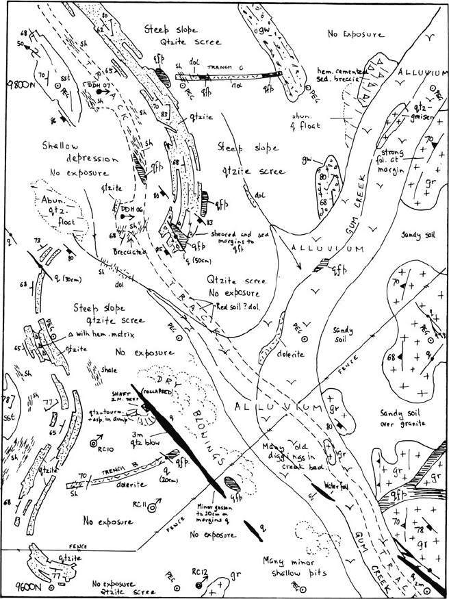
Fig. 2.13 An example of a 1:1,000 scale outcrop geological map of a mineral prospect in the
Northern Territory of Australia. This is one of a number of adjacent field sheets. Mapping was
controlled by a pegged grid on 100 × 50 m spacing
before the detail of the geology was recorded. As well as a survey control, in hilly
country the position of ridge lines and drainages are necessary to complement the
topographic contour information in order to understand the outcrop patterns of
shallow-dipping beds.

46 2 Geological Mapping in Exploration
As a general rule, the pegged grid should be regarded as a survey aid with no
geological significance. Above all, the grid is not necessarily to be regarded as a
predetermined set of traverse lines. In the field the geologist should follow her own
ideas on the geology, and not the grid line.
21
If the chosen mapping strategy is to
walk a traverse across strike then a traverse should be planned according to where
the most productive outcrop is to be found, always bearing in mind that traverses
do not have to be ruler-straight lines. For example, in many areas, often the only
outcrop is to be found is in stream beds, and these must feature prominently in the
mapping route chosen. The important thing to try to achieve is that the amount of
attention which any outcrop receives is in proportion to its geological importance,
not its closeness to a grid peg.
When it comes to positioning a feature on the map, a compass bearing can be
taken from the feature to the nearest grid peg. Usually, the peg will be sufficiently
close so that distance from peg to feature can be measured by pacing or even by
estimate, although more accurate location of the feature can be achieved by trian-
gulation between two or more grid pegs. To plot these measurements, a protractor
and scale ruler are necessary and important field mapping tools. Every point or line
placed on the map does not need to be accurately surveyed in. Once a network
of key points or lines has been exactly positioned, the remainder of the geological
boundaries are simply sketched in, so as to preserve the correct style and relation-
ships seen in the outcrop. This is illustrated in Fig. 2.13. On this map, the outcrop
boundaries are drawn so as to reflect the characteristic shapes of outcrop observed
for the different rock types: note that the quartzite outcrop shapes are well-defined
and rectilinear; the sandstone outcrop shape is massive and blocky; the shale has
insignificant low outcrop in narrow strike runs whilst the granite presents ovoid and
somewhat amoeboid outcrop shapes.
22
Observations are plotted as they are made, in pencil, on to the field map sheets
with the aim of creating a complete map in the field. Structural measurements are
plotted with the appropriate map symbol (using a square protractor), thus contin-
ually building up the geological picture as work progresses. There is no need to
record the measurements separately in a notebook, unless they are required for sub-
sequent structural analysis. Since the principal function of geological maps is, by
definition,
23
to show the distribution of strike, it is in most cases (for exception, see
21
In very dense scrub or forest, the cleared grid line often provides the only practicable traverse
route. Even here, however, every effort should be made to pick up significant outcrops between the
lines and to map cross-cutting access lines such as any tracks or creek sections.
22
This used to be called map-makers’ (or geologists’) wobble and is one of the things that can
distinguish a great geological map from a merely pedestrian one. This is not artistic licence: Chaos
Theory describes what the geologist is doing. For each lithology, the map outline of the outcrops
has a characteristic fractal dimension – a fraction somewhere between 1 and 2. The fractal number
is lowest for a “smooth” outline such as the granite, and highest for a “rough” outline such as the
quartzite.
23
Strikes are the trace of planes on maps just as dips are their trace on sections.
2.5 Mapping with Tape and Compass 47
below) much more useful to plot the strike and dip of measured planes on to the
map than dip and dip direction.
As far as map-scale pattern and outcrop distribution is concerned, the strike is
the most important measurement to make in terrain characterized by steep-dipping
structures. The opposite is true where very shallow-dipping beds predominate: in
such terrains, the strike can be quite variable and may have little significance, but
dips tend to be more constant and have much greater control on outcrop patterns of
rock units.
As the elements of the map are slowly assembled in this way, the map can be
used to make predictions about the areas not yet mapped and so guide the next set
of field observations, as described in Sect. 2.1.3.
2.5 Mapping with Tape and Compass
This technique is ideal for quickly making detailed geological maps of small areas
of high interest. The logistics of the technique mean that it is particularly suited to
making linear “strip” maps, such as maps of a stream section, ridge line, trench, road
cutting or a line of old pits and diggings. It is also a useful technique for surveying
in geological, topographic or cultural detail between the pegs of a widely spaced
grid or the established traverse points of a triangulation survey. A surveyor’s steel
chain or tape measure is the most accurate distance measuring devices but they can
only be easily used if an assistant is available. A Hip-Chain
TM
is less accurate but
is an acceptable alternative when time is short or there is no assistance available.
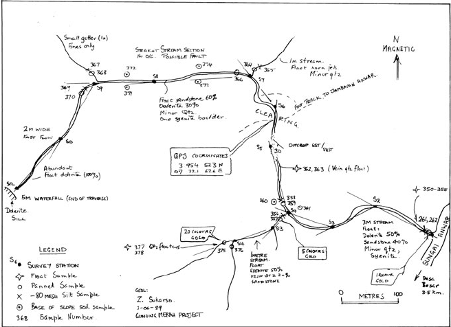
In the example shown (Fig. 2.14) a tape and compass survey has been used to map
a short drainage that was identified as anomalous during a regional stream sediment
survey. The map also provided an accurate base for plotting geological observations
and recording the location of the sample points of detailed follow-up geochemical
sampling.
The recommended procedure to make such maps is as follows:
• Start at one end of the area to be mapped. Knowing the approximate size and
orientation of the area to be covered, select a suitable scale and label the field
map sheet accordingly. Position the starting point of the traverse on the map.
• The assistant walks with one end of the tape to the first chosen survey point. The
geologist takes a bearing on the assistant and, knowing the distance, plots the
position of that point on to his or her field map sheet, using a protractor and scale
ruler. Alternatively, the geologist takes a bearing on the first point and then walks
to it, measuring the distance with the hip-chain. A good bearing compass such as
Suunto
TM
or prismatic should be used.
• If the ground is very steep, a correction for the vertical distance traversed will
have to be made to the tape interval. Measure the slope angle with a clinometer
and, knowing the ground distance between the points, correct the position of
the survey point as marked on to the map (for how to do this, see Sect. 2.4.1,
48 2 Geological Mapping in Exploration
Fig. 2.14 An example of a tape and compass map prepared during first-pass exploration of a
tropical rain forest covered area. The map was used as a base to record sample positions and
geological observations along a small stream during the follow-up to an initial stream sediment
gold anomaly in a panned heavy mineral concentrate taken from where the stream joins the main
river
above). Leaving the tape stretched along the ground, walk to the first survey point,
plotting geological observations along the traverse. Topographic details (such as
bends in a river bed) can be sketched in between the known points.
• Observations of geological features a short distance away from the survey line
can be recorded on the map by pacing or estimating distances, combined with
a compass bearing. If necessary, very accurate positioning can be obtained by
taking bearings from two known points of the traverse and triangulating, or by
taking one bearing from a known point and taping the distance to the feature. It is
not necessary to exactly survey in every feature that is to be recorded: once a few
points are established, all other observations can usually be positioned by eye in
relation to them with sufficient accuracy.
• Repeat the process to the next survey point and so on, to complete the traverse.
• Each surveyed point should be identified with a number on the map and marked
on the ground with plastic flagging, a metal tag or a survey stake. These are
exactly defined positions that can be used subsequently as a base for starting new
survey/mapping traverses away from the original line of observations.
• Make geological or geophysical observations or collect geochemical samples as
mapping proceeds, locating sample points directly on the map.
References 49
References
Chamberlin TC (1897) Studies for students: the method of multiple working hypotheses. J Geol
5(8):837–848
Popper K (1934) The logic of scientific discovery. Basic Books, New York, NY
Proffett JM (2004) Geologic mapping and its use in mineral exploration. In: Muhling J, Goldfarb N,
Vielreicher N, Bierlin E, Stumpfl E, Groves DI, Kenworthy S (eds) Predictive mineral discovery
under cover. SEG 2004 extended abstracts, vol 33. University of Western Australia, Centre for
Global Metallogeny, Nedlands, WA, 153–157
Pumpelly R, Wolff JE, Dale TN (1894) Geology of the green mountains. USGS Memoir 23:157p
Vearncombe J, Vearncombe S (1998) Structural data from drill core. In: Davis B, Ho SE (eds)
More meaningful sampling in the mining industry, vol 22. Bulletin/Australian Institute of
Geoscientists, Perth, WA, 67–82

Chapter 3
Mine Mapping
3.1 General
Detailed, scientific geological mine mapping began in the early years of the twenti-
eth century with the work of Reno Sales at Butte, Montana. The mapping was done
in-house for the Anaconda Copper Company, but the results were subsequently pub-
lished in a monumental work (Sales, 1913). The instigation for this work was partly
to solve legal disputes consequent upon the North American Apex Law of mineral
ownership, but the value of quality geological mapping in the search for extensions
to ore and in the development of theories on ore genesis was recognized early on.
The distribution of economic minerals within an ore deposit is a result of geologi-
cal controls. If the mineral distribution cannot be directly observed, other geological
effects related to that distribution often can be. Even with the most detailed assay-
ing based on grade-control drilling and sampling, the boundaries of ore can only
be adequately defined with the assistance of a geological map which shows the
spatial distribution these geological features. Only by preparing accurate, detailed
and up-to-date geological plans and sections of the mine can a drilling programme
be effectively planned to locate extensions to ore beyond the confines of the mine
openings.
Routine geological mapping of exposed rock faces within open-cut and under-
ground mines is thus an essential part of the mine geologist’s job.
3.2 Mapping in Open Cuts
Most basic geological data in open cuts are collected on vertical or near-vertical
exposed surfaces. Even before mining, although a surface geological plan is often
the starting point; the bulk of the information comes from holes drilled on vertical
sections. The interpretations of mine geology and ore-body shapes made prior to
mining are of necessity largely based on analysis of standard sections.
1
1
The observational data contained on standard level plans at this stage are usually an order of
magnitude less dense than those of the standard mine sections.
51
R. Marjoribanks, Geological Methods in Mineral Exploration and Mining, 2nd ed.,
DOI 10.1007/978-3-540-74375-0_3,
C
Springer-Verlag Berlin Heidelberg 2010
52 3 Mine Mapping
FLITCH
waste
ACTIVE MINING
FACES
BERM
BATTER
ore
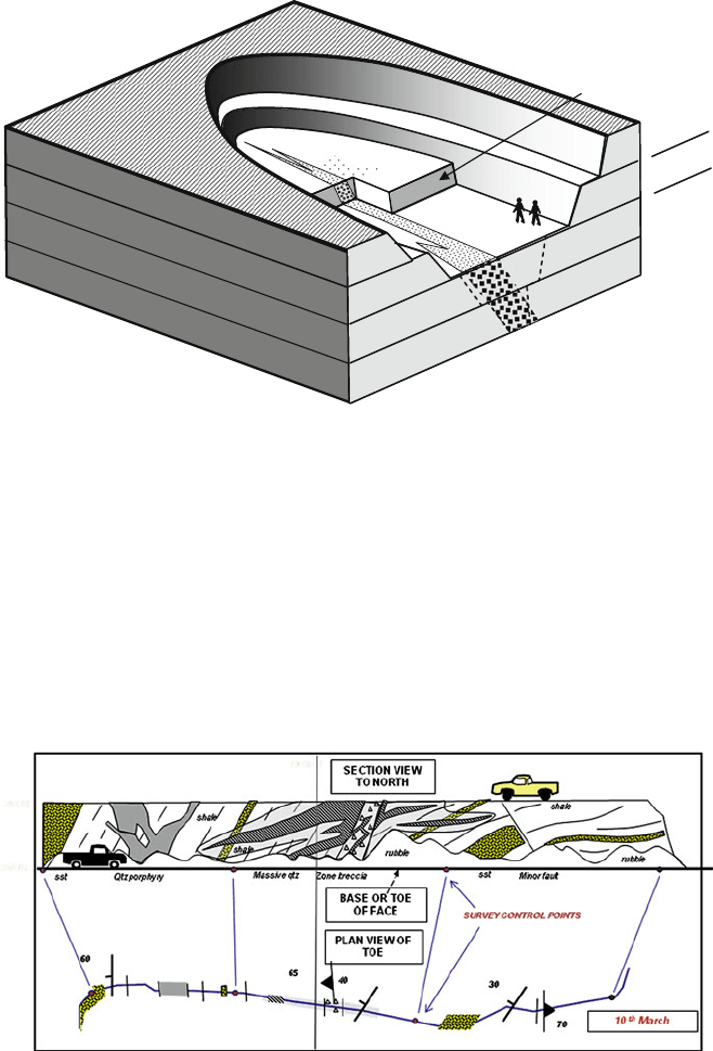
Fig. 3.1 Block diagram of a typical open cut mine. Access ramps have been omitted
Open-cut strip mining requires removing a series of horizontal slices (called
flitches) through an ore body and adjacent waste rock – a process known as flitch
mining (Fig. 3.1). The high-density, vertically distributed geological and assay data
therefore have to be “flipped over” and otherwise suitably extended in order to
predict and control the grade distribution of the flitches.
Mapping the exposed faces in the pit should be done on to field s heets (such as
graph paper). It is recommended that a detailed map be made of the vertical face,
as this is the surface that can be directly observed and so will contain the high-
est density of information (Fig. 3.2). A scale of 1:250 is generally adequate for pit
Fig. 3.2 Mapping the active mining face of an open cut mine. The face corresponds as near as
possible to a standard mine cross section. It is mapped as a section. A linear strip map of the base
or toe of the face is prepared at the same time. This data is compiled onto standard cross sections
and level plans (see Figs. 3.3 and 3.4)
3.2 Mapping in Open Cuts 53
mapping but, in areas of complexity, mapping at more detailed scales may be nec-
essary. The actual mapping procedure is in most cases a specialized application of
the tape and compass “strip mapping” procedures described in the previous chap-
ter. In some cases, particularly where extreme complexity is encountered (and the
miners allow the geologist sufficient time!), plane tabling is an effective mapping
technique. The position of the mapped face relative to the mine coordinates is estab-
lished by measuring a distance and bearing to some known surveyed point or points
in the mine.
At the same time as making the face map, the geologist should construct a
plan of the bottom (or “toe”) of the face, putting on to the plan structural mea-
surements and the position and strike of all significant contacts or structures seen
(Fig. 3.2). This plan provides a line of geological observation across the top of the
level below that being currently mined. As the base of the face is usually covered in
rubble, structures are plotted at the point where their down-dip projection intersects
the plan.
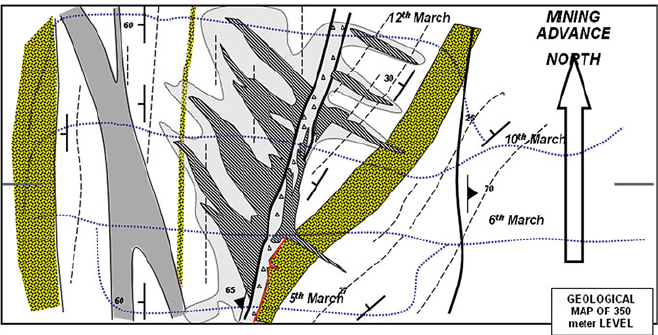
The plan view of the toe of the face is now used with plan views from previous
face positions to construct a geological map of the floor of the pit (Fig. 3.3). In
constructing the level plan, the face mapping can be complemented by pit floor
lithological mapping using a variety of techniques. These include:
• Mapping any outcrop, in situ rock fragments or colour changes on the pit floor.
• Using cuttings from grade-control or blast hole drilling to map lithologies.
• Digging a shallow s crape or trench across the pit floor using a bulldozer, grader
or trenching machine in order to expose identifiable rock.
Fig. 3.3 Geological interpretation of a mining level in an open cut mine. The map is compiled
from “toe” maps of the mining advance (Fig. 3.2), from any outcrop on the pit floor, and from
assay data. Extra geological information can be obtained by digging trenches or scrapes on the pit
floor
54 3 Mine Mapping
Although geological plans of each level are necessary to help determine grade
boundaries along the mining benches, complex geological relationships are best dis-
played, and are most readily interpreted, on section. The full value of face mapping
will not be realized unless faces mapped on different levels can be combined to
give a complete section through the ore body, as shown in Fig. 3.4. A section such
as this is based on near-continuous observation, and since it can readily be com-
bined with drill hole data, is an accurate and powerful tool for resolving details of
geology and mineralization. Such composite face maps are best compiled on stan-
dard mine sections. These are the close-spaced drill sections, arranged at regular
intervals along the strike of the ore body, which were used to define the ore body
prior to mining. Obviously, most temporary faces exposed in a pit as mining pro-
ceeds will not exactly correspond to a mine section. However, with the progressive
advance of mining, some faces will be developed which lie on such a section or close
enough to it to allow projection of data on to the section. It is worth making con-
siderable effort to ensure that these particular faces are not missed in the mapping
programme.
Pits being developed in oxidized material (in some deep weathering regimes this
can include the major part of the pit) can present special mapping problems. In such
deposits, mining usually proceeds at a fast pace, making it difficult to gain sufficient
access to a representative number of faces. In addition, weathered rocks are inher-
ently difficult to extract meaningful geological information from, particularly when,
as often happens, earth-moving equipment smears the high clay content across the
face. Obviously in such circumstances, observing and recording fine detail, partic-
ularly structural detail, is often not possible. However, face mapping should still be
attempted, as even a limited amount of mapping is better than none at all.
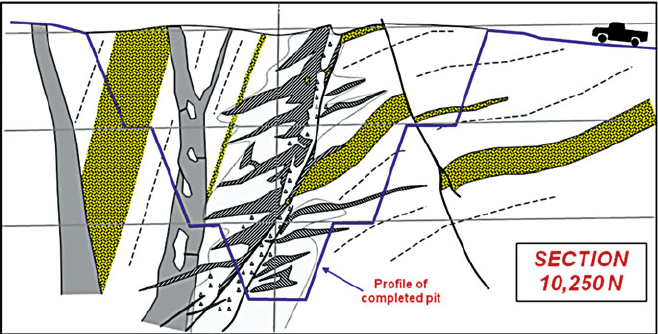
Fig. 3.4 Geological interpretation of a standard mine section. The section is compiled from face
mapping on each mine level (Fig. 3.2) and from drill hole information
3.2 Mapping in Open Cuts 55
Field mapping sheets do not need to be drafted or digitised but they should
be carefully filed for future reference. As soon as possible the field maps should
be directly transferred (photo reduce if necessary) to a digitised set of standard
scale geological level plans and sections that are maintained for the ore body. Such
plans and sections are usually at 1:250 or 1:500 scales. Geological information
that is collected, but not compiled in this way to build up a continuous three-
dimensional picture of the ore body and its host environment, is ultimately of little
value.
Mapping the open cut should not just be confined to those faces developed in ore.
All exposures within and adjacent to the ore body are relevant to understanding the
deposit and should be routinely mapped.
Knowing what is mappable in an open cut can only come from experience.
Initially, mapping may be slow and tedious until it is determined what geological
features can be consistently identified and correlated from face to face and level-to-
level. It is recommended that a reference set of rock-type specimens be collected to
ensure consistency in description. Similarly, photographs can be taken to help build
up an atlas of structural and textural features of the mine.
The sorts of geological features that might normally be mapped in an open cut
(and this is not an exclusive list) are:
• visible boundaries of ore and any other significant mineralization;
• boundaries of major lithological units;
• position and orientation of major structures such as folds, faults, prominent joint
sets, etc.;
• alteration patterns;
• major veins or vein sets;
• geotechnical data such as degree of fracturing,
• rock hardness, etc., as required by the engineers.
In the absence of mappable and well-defined lithological boundaries, use trend
lines to show the trace of continuous features that can be observed in the rock, such
as bedding planes, cleavage, joints or vein sets. Even where there are no discon-
tinuities to place on the map as a line, continuously variable parameters such as
degree of alteration, or number of veins (joints/fractures/shears) per meter, etc., can
be recorded as a map annotation. Such annotations can be in words (i.e. “highly
altered”), but it is usually better, if at all possible, to express the observation in
a semi-quantitative way (i.e. as a number between 1 and 5; as a percentage; as a
number of units per meter, and so on).
The nature of rock exposure in open cuts means that the best, and often the only,
way to measure the strike and dip of planar structure is to use a geologists’ compass
to sight from a distance onto the structure in the manner detailed in Appendix E.
In measuring a marker bed that is exposed across more than one batter, the strike
direction is easily determined from the floor of the pit by moving so as to align the
bed exposed on adjacent batters, as shown in Fig. 3.5.