Marjoribanks R. Geological Methods in Mineral Exploration and Mining
Подождите немного. Документ загружается.

2.2 Mapping Using Reflectance Imagery as a Map Base 25
• Plotting latitude and longitude coordinates in the field is difficult. Metric grid
coordinates such as UTM (Universal Transverse Mercator, for a detailed descrip-
tion see Sect. 10.5) are much easier to use. Make sure your GPS unit can provide
a fix in latitude/longitude and regional metric grid coordinates.
• In many parts of the Third World where explorationists operate, available
published maps are often based on poor-quality photogrammetry with little
or no ground checking. Such maps can be highly inaccurate. Even where
photogrammetry-based maps have been made with care, in heavily forested coun-
try the map-maker has often been unable to accurately position smaller streams,
roads or villages because of the obscuring tree canopy. In these areas, the GPS
fix, being more accurate than the map, can be very misleading when it comes to
trying to locate a particular feature.
2.2 Mapping Using Reflectance Imagery as a Map Base
2.2.1 General
Light from the sun reflects from the earth’s surface and radiates in all directions,
including (provided it is not blocked by clouds) back into space. Any system which
can record the intensity and wavelengths of the reflected light and reproduce the
data as an image, is known as reflectance imagery. The instrument that does this
can be mounted on either an aircraft or satellite. The word photograph is specif-
ically used for images recorded onto photographic film by a camera lens system.
This section deals primarily with air photographs – i.e. photographs taken look-
ing vertically down from an aircraft – but most of the comments apply equally
to the handling and use of hard copy satellite images. Details about how satellite
images are acquired and presented, and how they can be used as a remote sensing
geophysical tool (spectral geology), will be found in Chap. 8.
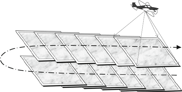
In air photography, a camera mounted in an aircraft takes a series of photographs
as the plane flies in regular parallel passes over the terrain. Air photographs have the
advantage of being relatively cheap to collect and, since they are taken at low alti-
tude, can show great detail. Overlapping adjacent photographs along the flight path
(Fig. 2.3) enables subsequent stereoscopic (3-dimensional) viewing (Fig. 2.5). Air
photographs typically offer a resolution of ground features that range in size from a
few centimetres upwards, depending on the height of the aircraft above the ground
and the quality of the camera optics used. Film is an analog method of recording
data that offers exceptionally high resolution that is ultimately limited only by the
grain size of the chemical emulsion on the film. The resolution of the film used for
air photographs is an order of magnitude greater that is currently achievable with
electronic recording methods. Air photographs are typically collected for normal
viewing at scales of from 1:500 to 1:100,000, but, unlike digital images, they can be
enlarged many times without losing resolution.
26 2 Geological Mapping in Exploration
CLICK !
1 2
3
4
5
6
12
11
10
9
8
7
20% side lap
60% forward lap
RUN ONE
RUN TWO
Fig. 2.3 Typical specification of an air photo survey designed to obtain full stereo coverage
2.2.2 Acquiring Air Photographs
Many governments (including all first world countries) have acquired air photo
coverage of their territories and these can usually be purchased from the relevant
government agency. Needless to say, the quality and coverage of this product varies
enormously, but since it is a cheap resource, it is always worth checking to see
what is available. In areas where there has been a high level of mineral explo-
ration, surveys flown by previous explorers may also be available. If none of these
avenues yields a useful product, it is possible to commission your own survey. This
is comparable in cost to purchasing high resolution satellite imagery for the same
area and gives the opportunity to specify a scale and coverage that will suit your
project.
2.2.3 Geological Interpretation
Air photographs (along with other similar remote sensed products such as satellite
and radar imagery) provide both a mapping base on which to record field observa-
tions and an integrated view of landscape on which map-scale patterns of lithology
and structure can be directly observed or interpreted. Where available at a suitable
scale and resolution, they are the pre-eminent medium upon which to construct a
geological map.
For any geological mapping programme making use of remote sensed imagery,
image interpretation represents the idea-generating, integrative, control and plan-
ning phases of that programme. The initial interpretation made from the images will
provide:

2.2 Mapping Using Reflectance Imagery as a Map Base 27
• definition of areas of outcrop and areas of superficial cover;
• preliminary geological interpretation based on topographic features, drainage
patterns, colours and textures of rocks, soils and vegetation, trend lines of linear
features, etc.;
• geological hypotheses for field checking;
• selection of the best areas to test these hypotheses;
• familiarity with the topography and access routes to assist in logistic planning
of the field programme – access roads and tracks, fording points for streams and
gullies, potential helicopter landing sites, etc.
Air photo or satellite image interpretation needs to be carried out before, during
and after the field phases of the mapping process. Obviously, detailed interpretation
making use of stereo viewing can be most conveniently done at an office desk, but,
as ideas change or evolve, interpretation of photo features will have to be attempted
in the field as well. The ability to use a pocket stereoscope on the outcrop is an
essential skill to acquire.
Since making and interpreting geological observations on the photo and outcrop
are two aspects of the same process, they should ideally be carried out by the same
person.
13
Whenever possible, the field geologist should do his own interpretation.
Geological interpretation of remote sensed imagery complements field mapping
and should never be regarded as an adequate substitute for it.
Skills required for the geological interpretation of remote sensed imagery are
very much the same as those needed for field mapping. However, some practical
techniques need to be learned in order to turn air photo observations into usable
geological maps. The next section describes some of these techniques.
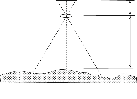
2.2.4 Determining Scale
The scale of an air photograph is determined by the height above the ground of
the airplane taking the photograph, divided by the focal length of the camera used
(Fig. 2.4). Thus:
Photo scale = 1:
Airplane height above ground
Focal length of camera
A scale is generally printed onto the edge of an air photograph but this is a nomi-
nal scale only and should always be checked for a number of scenes across the area
of the air photo survey.
13
Highly skilled and experienced geologists are available who specialize in the field of air photo
and satellite image interpretation. Their use is indicated for training purposes; where they have
particular knowledge of the geology or landforms in the area to be mapped; or where there is little
possibility of any substantial field access to the region.
28 2 Geological Mapping in Exploration
Scale of photo =
h
f
f : focal length of camera
h
: height of camera
above ground
Camera lens
Photo image
Scene
Fig. 2.4 How to calculate the scale of an air photograph
The airplane altimeter height (i.e. height above sea level) and camera focal length
are also normally marked on to the edges of an air photograph and provide a means
of calculating the exact scale, using the above formula, provided the average height
of the ground above sea level is known for that scene. Cameras designed for photo-
graphic surveys have very long focal lengths to enable them to fly at greater heights
for a given scale.
Even though the pilot of the plane tries to maintain a constant ground height
whilst flying a photographic survey, this is not always possible. The scale can thus
vary from image to image. The variation in scale from this cause is usually small,
but is greatest for large-scale photographs and in areas of strong relief.
Another way of checking the scale is to measure the length of a known feature
in the central portion of the photo (such as a section of road or stream) and compare
it with the same section identified on a detailed topographic map of the same area.
Make several such measurements along different bearings on each image and take
the average to get the true scale for the scene.
In addition to these scale variations, the stated photo scale is correct only for
the central area of the photograph and is progressively distorted towards its edges.
Since the distortion increases exponentially outwards, the central 60% of the scene
has only minimal distortion which can generally be ignored. The radial distortion
also affects angular relationships. For this reason, if at all possible, interpretation
should not be carried to the edges of a photograph. This is easy to do on the edges
of photos along the flight line (the forward lap) where a 60% overlap is usually

2.2 Mapping Using Reflectance Imagery as a Map Base 29
available with adjacent frames, but more difficult on the photo edges across the
flight line (the side lap) where the overlap with adjacent runs is generally only
20%
14
or less.
Air photos usually have a north arrow plotted on their edge but this arrow cannot
necessarily be taken as accurate – any yawing of the plane at the moment when
the photo was taken can make this considerably in error. This problem will usually
affect only a few photographs and can be picked up and corrected when adjacent
photos are compared during the initial interpretation period. It is a good idea to
compare each photo with a topographic base map and, where necessary, correct the
north arrow marked on the photograph.
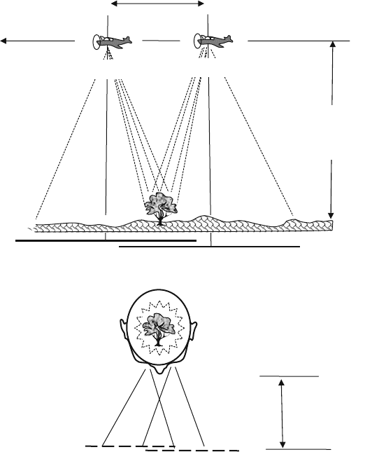
2.2.5 Stereoscopic Image Pairs
When images of a feature from two different angles are taken, there is a relative
shift in the apparent position of the feature on the images. This effect is known as
parallax. The two images form a left and right stereo pair and, taken together, contain
three dimensional information about the feature. To recover this information, the
images must be arranged for viewing so that the left eye sees the left image and
the right eye sees the right image. The brain then combines the two views to create
a three-dimensional impression of the feature, in exactly the same way as the eye-
brain combination would have created three-dimensional information if they had
directly viewing the feature in the real world.
Images are normally placed for viewing at a distance of around 200 mm from the
eyes (H – height), and eyes are approximately 55–65 mm apart (B – base distance).
On viewing stereoscopic image pairs, the ratio of height to base (H:D) is there-
fore around 3. If the same ratio is used during acquisition of the images there will
be no scale distortion on viewing. For example, to take scale-correct stereoscopic
photographs of an outcrop in the field, follow the procedure:
1. photograph the outcrop – this becomes the left image;
2. estimate the distance (H) to the outcrop (say, 12 m);
3. step a distance of H/3 (B) to the right (4 m in our example) and take a second
photograph of the outcrop – this becomes the right image.
When subsequently mounted side by side on the page of a notebook or report,
the two images, when viewed so that the left eye sees the left image and the right
eye the right image; will give a distortion-free 3-dimentional view of the outcrop.
Figure 2.5 illustrates an air photo survey with a plane flying at 200 m taking pho-
tographs of the ground beneath it every 65 m. For this survey the ratio of H to B is 3
14
Photography for mountainous areas, where flying predetermined flight lines may be difficult,
needs a wider side lap of 25% or more.
30 2 Geological Mapping in Exploration
OBSERVER
D: (eye spacing) = 65 mms
H = 200 mms
Image 1
Image 2
D = Distance between
adjacent image centres
65 meters
H : Height of
camera above
ground
200 meters
Click !
Click !
Area of Image 1
Area of Image 2
TREE
In the area of
image overlap,
each object,
such as a tree, is
photographed
twice, but from a
slightly different
angle
Fig. 2.5 How the perception of depth in a stereoscopic photo pair is determined. When viewing
images, the ratio of the distance between the eyes (D) and the distance to the image (H) is approx-
imately 3. If the images have been collected using the same ratio of D to H – as illustrated – there
will be no vertical scale distortion on viewing. If the ratio of H/D is greater than 3 (which would
occur if the photos were taken closer together or from a greater height above ground) viewing the
stereo pair will exaggerate the apparent height of object
so there will be no vertical exaggeration when viewing adjacent images stereoscop-
ically. However, with almost all air photo surveys, a height to base ratio of 3 would
entail flying very low and require an unacceptably large number of photographs to
cover any significant area. Because of this, most surveys are flown with an H:B ratio
greater than 3, leading to an exaggeration of the vertical dimension on stereoscopic

2.2 Mapping Using Reflectance Imagery as a Map Base 31
viewing – i.e. objects appear much steeper than they are in reality. Vertical exag-
geration can be a useful feature in very flat terrain, as small height variations are
emphasised, but in rugged terrain the effect can be rather startling, and needs to be
allowed for. Dips of outcropping strata, for example, will appear much steeper than
they really are.
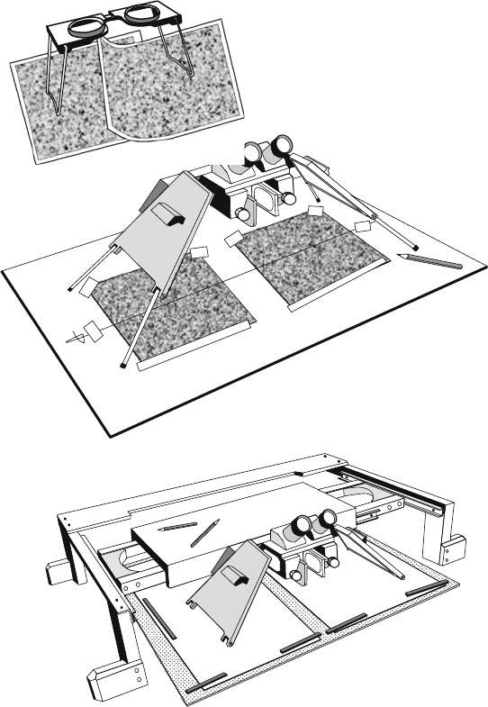
With practise it is possible to view small stereo pairs and get the stereo effect
without any optical aid. This can be a handy skill to acquire, but it will only ever
work for small size images that can be placed close together. Optical instruments
called stereoscopes make this process much easier and they are essential for view-
ing large format images. The smallest and cheapest stereoscopes are small folding
models (Fig. 2.6) – these can be very useful for viewing air photographs in the field.
However, pocket stereoscopes have generally poor optics and offer no, or very low,
magnification. A further disadvantage is that with standard size air photographs it
is necessary to bend back the edge of one print in order the view the entire overlap
area of a photo pair.
To achieve the full benefit from stereoscopic viewing of air photographs or
satellite images, a mirror stereoscope is necessary. Many different models of mir-
ror stereoscope are commercially available, but it is important to remember that
with these, as with all optical instruments, you get what you pay for. The best
models come with binocular eyepieces and offer enlargements of the image up to
10× (Fig. 2.6). Large mirror stereoscopes will comfortably span a pair of air pho-
tographs, although the instrument has to be moved from side to s ide and back and
forward to cover the full overlap area. If the stereoscope is mounted on a frame
that permits unimpeded horizontal movement above the images the viewing process
can be made considerably easier. Such mounting frames are essential for viewing
very large format stereoscopic pairs such as satellite images. Commercial frames
(often called mounting “tables”) are available but these are expensive and sometimes
make annotation of the images difficult. Figure 2.6 illustrates a cheap and easily
made homemade stereoscope mounting frame which has proved very effective for
geological interpretation
15
of air photographs and satellite images.
2.2.6 Image Handling Techniques
• Surface reflectance can be a problem on highly glazed prints. Such prints also
tend to curl and dog-ear more easily than matt prints. For this reason most geolo-
gists prefer to order prints with a matt surface for fieldwork. However, high-gloss
prints reflect more light and for that reason can be easier to read below a film
overlay.
15
The frame is made from wood and aluminium angle. It is articulated using standard wheeled
drawer runners.
32 2 Geological Mapping in Exploration
(a) FOLDING POCKET
STEREOSCOPE
(c) STEREOSCOPE MOUNTING TABLE
(b) MIRROR
STEREOSCOPE
(Topcon MS3)
Thin sheet steel
Air photograph
Air photograph
Fig. 2.6 Different types of stereoscope. With a small pocket stereoscope (a) the edge of one pho-
tograph needs to be bent back in order to view the whole overlap area of air photographs. A large
mirror stereoscope (b) will span a pair of standard air photographs and can be easily slid around
to view the whole image. A stretched thread is used as an aid in aligning photo centres with the
optical axis of the scope. The steel sheet allows plastic strip magnets to be employed to hold photos
flat and in place. For stereoscopic viewing of large prints such as satellite images, mounting the
stereoscope in a frame (c) that allows it unimpeded movement above the images is essential. The
mounting table illustrated was made by the author from aluminium angle and wood – it is artic-
ulated with wheeled drawer runners to allow smooth movement from side to side and back and
forward. A fluorescent light attached to the underside of the stereoscope carriage illuminates the
images
2.2 Mapping Using Reflectance Imagery as a Map Base 33
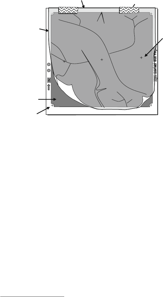
Run 6 5021
Drafting tape hinge attaches clear overlay to
photo along side
- lap edge
Overlay labelled for future filing
North arrow
Altimeter reading
Date/time stamp
Project Run and Sequence number
Broad topographic
and cultural features
traced onto overlay
for survey control.
Extra detail needed in
areas of photo
overlap. Use colour
to distinguish from
geological
interpretation
Centre of
adjacent photo
Photographic
Image
Clear overlay
Centre location
(collimation) mark
Cloncurry
20/9/03
R6/5021
Photo Centre
Fig. 2.7 An air photograph prepared as a base for geological mapping
• It is recommended that interpretations of the remote sensed imagery be marked
on to a clear overlay.
16
The overlay should be attached to the top edge of the
image (i.e. the upper or side lap edge of air photographs) so that it can be rolled
back clear from the adjacent image and stereo viewer frame. Experience shows
that drafting tape is best for attaching the overlay to the print as it will not split
along the fold and can be easily removed (Fig. 2.7). When working with air pho-
tographs that have full stereo coverage (60% forward lap), it is only necessary to
put overlays on every second photograph.
• With satellite stereo pairs, computer processing ensures that the right hand image
is orthorectified and georeferenced (see Sects. 8.4 and 10.5 for definition of these
terms) while the parallax displacements that contain information about the ver-
tical relief of the scene are placed on the left hand image. When viewing these
images, the clear overlay should be attached to the top edge of the RH image
and all annotations and interpretations made on to this sheet. This means that
interpreted geology will automatically be an ortho map.
• An alternative method used by some geologists is to mark observations directly
onto the surface of the image using a pencil that does not damage the print and can
be readily removed (e.g. a chinagraph or omnichrome pencil). However, putting
16
Overlays are available in pre-cut sheets of clear to part-translucent drafting film. Clear sheets do
not obscure the photo below, but are difficult to write on without special writing materials. Matt
surface films readily take pencil marks but may have to be flicked out of the way when detail of
the photo has to be observed.

34 2 Geological Mapping in Exploration
interpretation lines on a print surface obscures the original detail of the image on
which these lines were based and makes it hard to see alternative interpretations.
This can make it difficult to change early interpretations.
• The overlay should be labelled with the image identification number or the run
number and photo sequence number (Fig. 2.7).
• With air photographs, the centre point (sometimes called the principal point) of
the photo should be located. This point lies at the intersection of lines joining spe-
cial location marks which are printed in the centre of each edge of the photo (these
marks are called collimation marks and are sometimes in the corner of the photo).
• Locate (by inspection) on each air photo the centre points of the adjacent photos
along the flight path. This can be done because of the 60% forward lap between
photos. There will thus be three points located on each photo. Transfer these
points to the overlay.
• In order to position adjacent photographs so that they are exactly aligned for
stereo viewing the following procedure can now be used. Place adjacent photos
side by side below the stereo-viewer so that the three centre points marked on
to each photo lie as nearly as possible along a single straight line (a stretched
thread can make this procedure easier , as shown on Fig. 2.6). The straight line
should line up with the “E–W” optical axis of the stereoscope. Looking at the
photographs through the viewer, move the photos together or apart along that line
so as to bring them into stereoscopic alignment. Once this is achieved, the pho-
tographs are positioned so that most
17
of their area of overlap is correctly aligned
for stereo viewing and it should need only minimal subsequent adjustment as the
field of the viewer is moved across the images.
• When working in the field in areas with complex geology and mineralization,
annotations marked on to an air photo overlay can become very crowded. Many
geologists overcome this by using up to three overlays, mounted separately on
three sides of the photo. One overlay can then be used for showing lithologies,
one for structural observations and the third for mineralisation and alteration.
• Another way of organizing information on the photo overlay when working in
the field is to mark a location by means of a small pin-hole pricked through the
print (Fig. 2.8). Information about that location, such as sample number, notebook
reference number, GPS way point number and so on, is then written on the back
of the print.
2.2.7 Working with Enlarged Air Photographs
Air photographs can be enlarged many times
18
and still provide a useable base
map for field work. The enlargement has to be made photographically from the
original film negative and only the central 60% of each photo (where distortion is
17
It is generally impossible to exactly align all the overlap area of the photos due to edge
distortions.
18
Air photos enlarged up to 20 times have been successfully used as mapping bases.