Houze Robert A., Jr. Cloud Dynamics
Подождите немного. Документ загружается.

1.2 Cloud Types Identified Visually 19
wider area). Or it may be the upper-level leading or trailing canopy of a nimbo-
stratus cloud. A common form of cirrostratus is the leading canopy of a frontal
cloud system (as can be seen in satellite pictures such as those shown below in
Sec. 1.3.3). A common feature of cirrostratus is the halo produced as the sun
shines through the layer of ice particles (Fig. 1.17).
1.2.5 Orographic Clouds
Air moving over or around hilly or mountainous terrain often influences cloud
formation. Many of the basic cloud genera and species already described can be
forced, triggered, or enhanced orographically. For example, mountain ranges are
typically preferred locations for fog, stratus, stratocumulus, cumulus, and cumu-
lonimbus, and they affect the structure and precipitation of nimbostratus clouds
associated with weather systems such as fronts. Valleys between mountains often
favor fog occurrence. In addition to the modification of the cloud types that may
occur anywhere, there are cloud forms that are uniquely associated with topogra-
phy, and Chapter 12 is devoted to the dynamics of these truly orographic clouds.
As mentioned above, the lenticularis species describes some of these cloud forms.
Lenticular clouds form when air flows over a mountain. If the mountain is in the
form of an isolated peak, a cap cloud may form directly on the top of the mountain
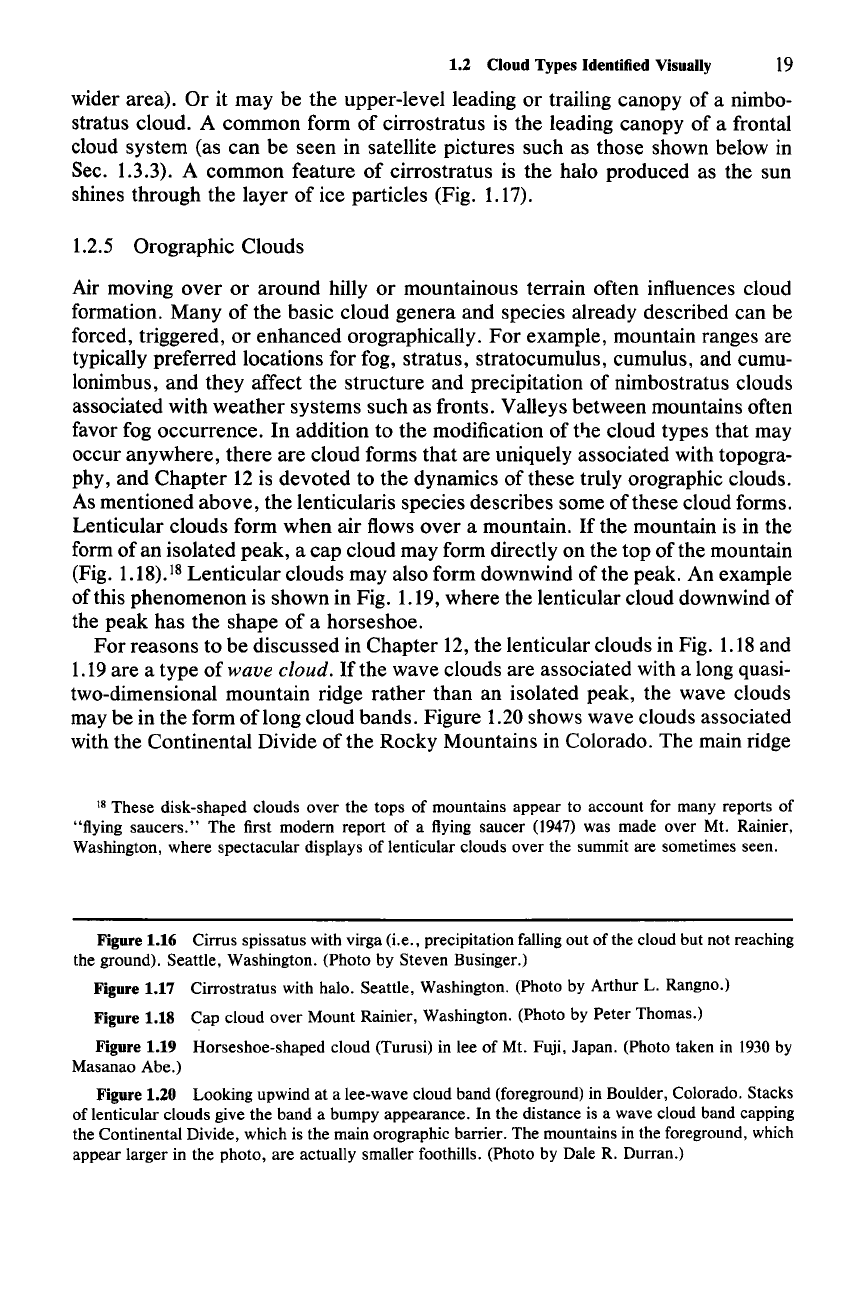
(Fig.
1.18).18
Lenticular clouds may also form downwind of the peak. An example
of this phenomenon is shown in Fig. 1.19, where the lenticular cloud downwind of
the peak has the shape of a horseshoe.
For
reasons to be discussed in Chapter 12, the lenticular clouds in Fig. 1.18and
1.19are a type of wave cloud. If the wave clouds are associated with a long quasi-
two-dimensional mountain ridge rather than an isolated peak, the wave clouds
may be in the form oflong cloud bands. Figure 1.20 shows wave clouds associated
with the Continental Divide of the Rocky Mountains in Colorado. The main ridge
18 These disk-shaped clouds over the tops of mountains appear to account for many reports of
"flying saucers." The first modern report of a flying saucer
(1947)
was made over Mt. Rainier,
Washington, where spectacular displays of lenticular clouds over the summit are sometimes seen.
Figure 1.16 Cirrus spissatus with virga (i.e., precipitation falling out of the cloud but not reaching
the ground). Seattle, Washington. (Photo by Steven Businger.)
Figure 1.17 Cirrostratus with halo. Seattle, Washington. (Photo by Arthur
L. Rangno.)
Figure 1.18 Cap cloud over Mount Rainier, Washington. (Photo by Peter Thomas.)
Figure 1.19 Horseshoe-shaped cloud (Turusi) in lee of Mt. Fuji, Japan. (Photo taken in
1930 by
Masanao Abe.)
Figure 1.20 Looking upwind at a lee-wave cloud band (foreground) in Boulder, Colorado. Stacks
of lenticular clouds give the band a bumpy appearance. In the distance is a wave cloud band capping
the Continental Divide, which is the main orographic barrier. The mountains in the foreground, which
appear larger in the photo, are actually smaller foothills. (Photo by Dale R. Durran.)
20 1 Identification of Clouds
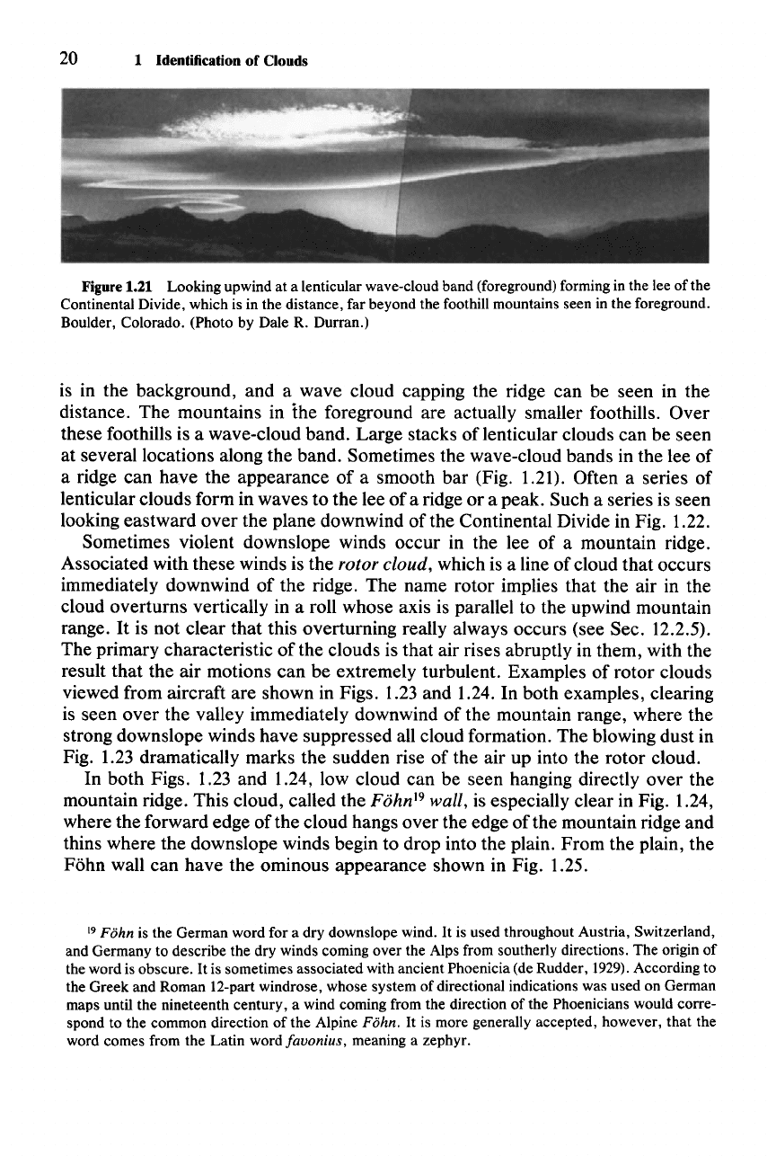
Figure 1.21 Looking upwind at a lenticular wave-cloud band (foreground) forming in the lee of the
Continental Divide, which is in the distance, far beyond the foothill mountains seen in the foreground.
Boulder, Colorado. (Photo by Dale R. Durran.)
is in the background, and a wave cloud capping the ridge can be seen in the
distance. The mountains in the foreground are actually smaller foothills. Over
these foothills is a wave-cloud band. Large stacks of lenticular clouds can be seen
at several locations along the band. Sometimes the wave-cloud bands in the lee of
a ridge can have the appearance of a smooth bar (Fig. 1.21). Often a series of
lenticular clouds form in waves to the lee of a ridge or a peak. Such a series is seen
looking eastward over the plane downwind of the Continental Divide in Fig. 1.22.
Sometimes violent downslope winds occur in the lee of a mountain ridge.
Associated with these winds is the
rotor cloud, which is a line of cloud that occurs
immediately downwind of the ridge. The name rotor implies that the air in the
cloud overturns vertically in a roll whose axis is parallel to the upwind mountain
range.
It
is not clear that this overturning really always occurs (see Sec. 12.2.5).
The primary characteristic of the clouds is that air rises abruptly in them, with the
result that the air motions can be extremely turbulent. Examples of rotor clouds
viewed from aircraft are shown in Figs. 1.23 and 1.24. In both examples, clearing
is seen over the valley immediately downwind of the mountain range, where the
strong downslope winds have suppressed all cloud formation. The blowing dust in
Fig. 1.23 dramatically marks the sudden rise of the air up into the rotor cloud.
In both Figs. 1.23 and 1.24, low cloud can be seen hanging directly over the
mountain ridge. This cloud, called the
Fohn'? wall, is especially clear in Fig. 1.24,
where the forward edge of the cloud hangs over the edge of the mountain ridge and
thins where the downslope winds begin to drop into the plain. From the plain, the
Fohn wall can have the ominous appearance shown in Fig. 1.25.
19 Fohn is the German word for a dry downslope wind. It is used throughout Austria, Switzerland,
and Germany to describe the dry winds coming over the Alps from southerly directions. The origin of
the word is obscure.
It
is sometimes associated with ancient Phoenicia (de Rudder, 1929).According to
the Greek and Roman 12-part windrose, whose system of directional indications was used on German
maps until the nineteenth century, a wind coming from the direction of the Phoenicians would corre-
spond to the common direction of the Alpine
Fohn.
It
is more generally accepted, however, that the
word comes from the Latin wordfavonius, meaning a zephyr.
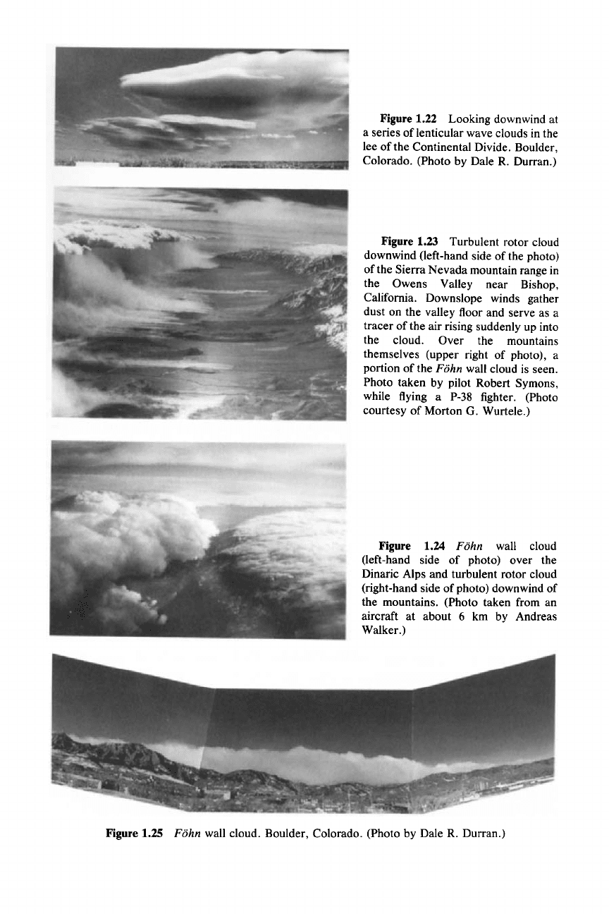
Figure 1.22 Looking downwind at
a series of lenticular wave clouds in the
lee
ofthe
Continental Divide. Boulder,
Colorado. (Photo by Dale R. Durran.)
Figure 1.23 Turbulent rotor cloud
downwind (left-hand side of the photo)
of the Sierra Nevada mountain range in
the Owens Valley near Bishop,
California. Downslope winds gather
dust on the valley floor and serve as a
tracer of the air rising suddenly up into
the cloud. Over the mountains
themselves (upper right of photo), a
portion of the Fohn wall cloud is seen.
Photo taken by pilot Robert Symons,
while flying a P-38 fighter. (Photo
courtesy of Morton G. Wurtele.)
Figure 1.24 Fohn wall cloud
(left-hand side of photo) over the
Dinaric Alps and turbulent rotor cloud
(right-hand side of photo) downwind of
the mountains. (Photo taken from an
aircraft at about 6 km by Andreas
Walker.)
Figure 1.25 Fohn wall cloud. Boulder, Colorado. (Photo by Dale R. Durran.)
22 1 Identification of Clouds
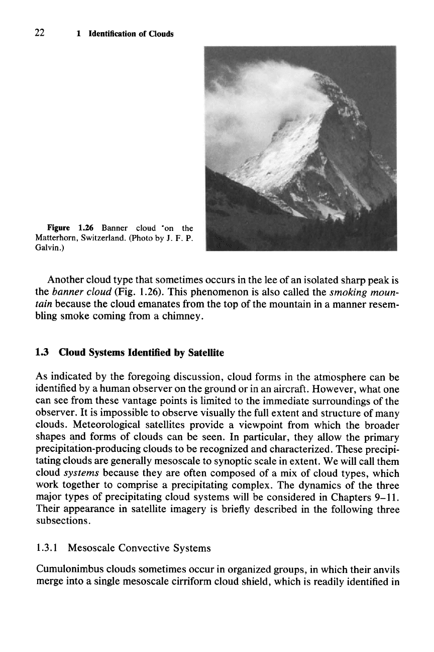
Figure 1.26 Banner cloud "on the
Matterhorn, Switzerland. (Photo
by J. F. P.
Galvin.)
Another cloud type that sometimes occurs in the lee of an isolated sharp peak is
the banner cloud (Fig. 1.26). This phenomenon is also called the smoking moun-
tain because the cloud emanates from the top of the mountain in a manner resem-
bling smoke coming from a chimney.
1.3 Cloud Systems Identified by Satellite
As indicated by the foregoing discussion, cloud forms in the atmosphere can be
identified by a human observer on the ground or in an aircraft. However, what one
can see from these vantage points is limited to the immediate surroundings of the
observer.
It
is impossible to observe visually the full extent and structure of many
clouds. Meteorological satellites provide a viewpoint from which the broader
shapes and forms of clouds can be seen. In particular, they allow the primary
precipitation-producing clouds to be recognized and characterized. These precipi-
tating clouds are generally mesoscale to synoptic scale in extent. We will call them
cloud systems because they are often composed of a mix of cloud types, which
work together to comprise a precipitating complex. The dynamics of the three
major types of precipitating cloud systems will be considered in Chapters
9-11.
Their appearance in satellite imagery is briefly described in the following three
subsections.
1.3.1 Mesoscale Convective Systems
Cumulonimbus clouds sometimes occur in organized groups, in which their anvils
merge into a single mesoscale cirriform cloud shield, which is readily identified in
1.3 Cloud Systems Identified by Satellite 23
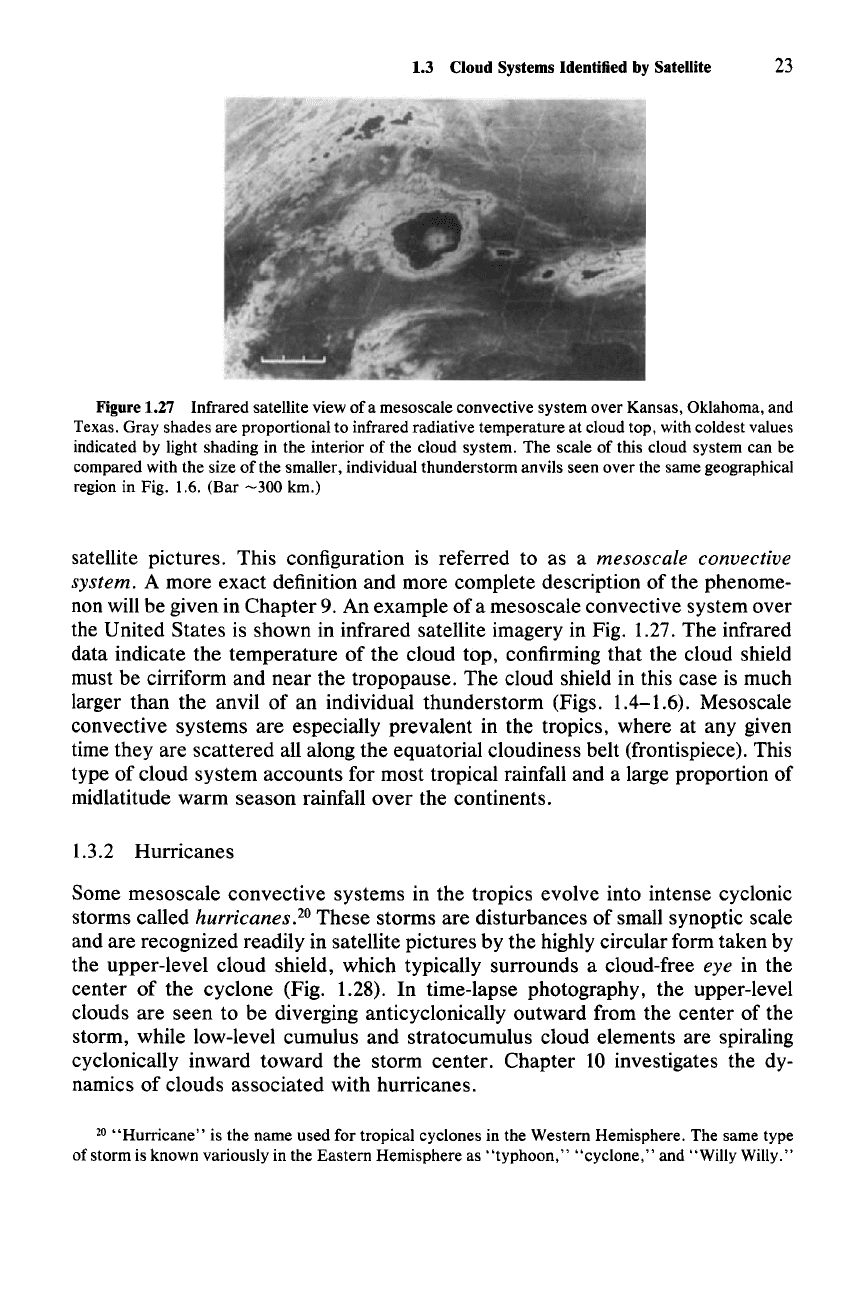
Figure 1.27 Infrared satellite view of a mesoscale convective system over Kansas, Oklahoma, and
Texas. Gray shades are proportional to infrared radiative temperature at cloud top, with coldest values
indicated by light shading in the interior of the cloud system. The scale of this cloud system can be
compared with the size
ofthe
smaller, individual thunderstorm anvils seen over the same geographical
region in Fig. 1.6. (Bar
-300
km.)
satellite pictures. This configuration is referred to as a mesoscale convective
system.
A more exact definition and more complete description of the phenome-
non will be given in Chapter 9. An example
of
a mesoscale convective system over
the United States is shown in infrared satellite imagery in Fig. 1.27. The infrared
data indicate the temperature
of
the cloud top, confirming that the cloud shield
must be cirriform and near the tropopause. The cloud shield in this case is much
larger than the anvil
of
an individual thunderstorm (Figs. 1.4-1.6). Mesoscale
convective systems are especially prevalent in the tropics, where at any given
time they are scattered all along the equatorial cloudiness belt (frontispiece). This
type of cloud system accounts for most tropical rainfall and a large proportion of
midlatitude warm season rainfall
over
the continents.
1.3.2 Hurricanes
Some mesoscale convective systems in the tropics evolve into intense cyclonic
storms called
hurricanes.20 These storms are disturbances of small synoptic scale
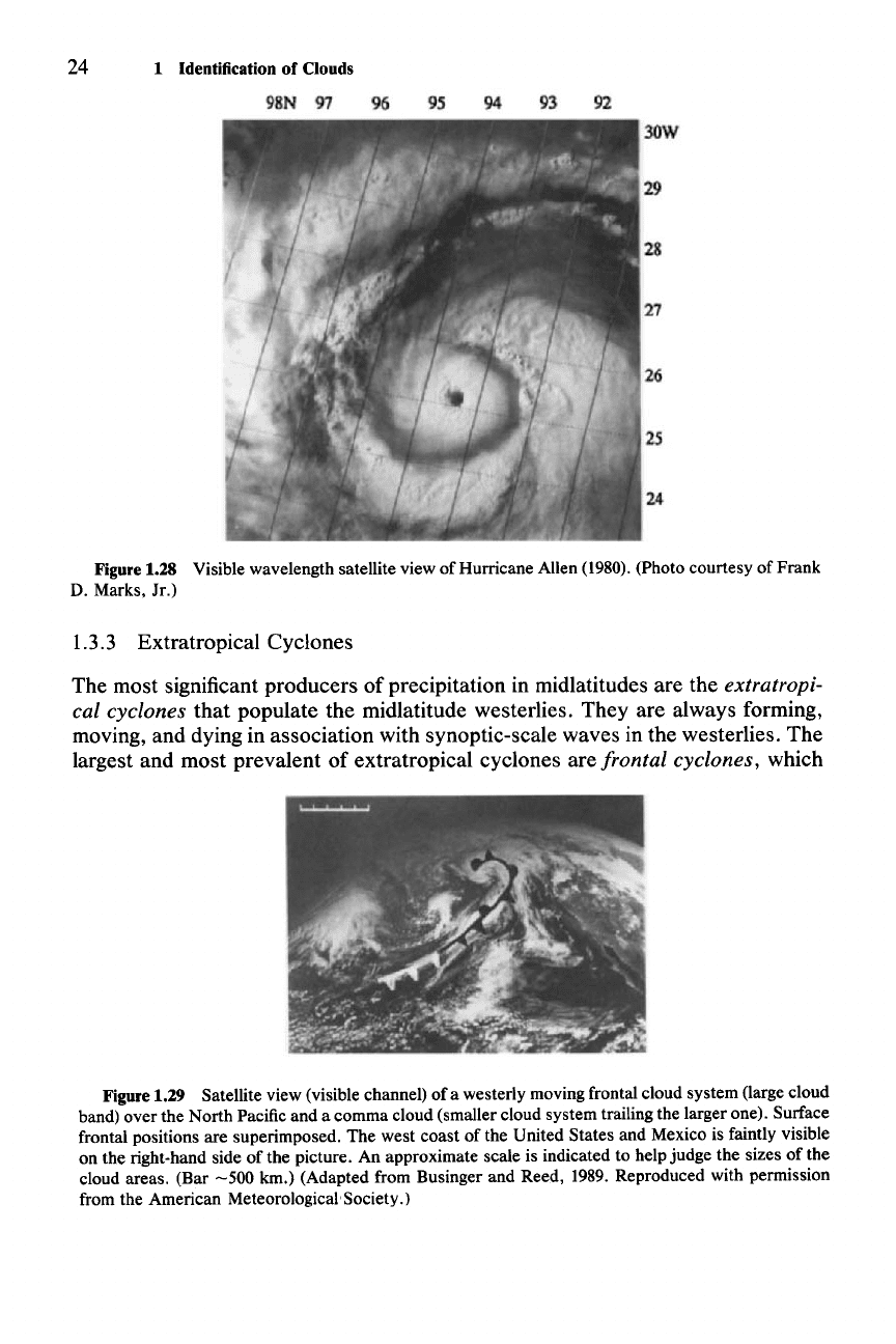
and are recognized readily in satellite pictures by the highly circular form taken by
the upper-level cloud shield, which typically surrounds a cloud-free
eye in the
center of the cyclone (Fig. 1.28). In time-lapse photography, the upper-level
clouds are seen to be diverging anticyclonically outward from the center of the
storm, while low-level cumulus and stratocumulus cloud elements are spiraling
cyclonically inward toward the storm center. Chapter 10 investigates the dy-
namics of clouds associated with hurricanes.
20
"Hurricane"
is the name used for tropical cyclones in the Western Hemisphere. The same type
of storm is known variously in the Eastern Hemisphere as
"typhoon,"
"cyclone," and "Willy Willy."
24 1 Identification of Clouds
Figure 1.28 Visible wavelength satellite view of Hurricane Allen (1980). (Photo courtesy of Frank
D. Marks,
Ir.)
1.3.3 Extratropical Cyclones
The most significant producers of precipitation in midlatitudes are the extratropi-
cal cyclones that populate the midlatitude westerlies. They are always forming,
moving, and dying in association with synoptic-scale waves in the westerlies. The
largest and most prevalent of extratropical cyclones are frontal cyclones, which
Figure 1.29 Satellite view (visible channel) of a westerly moving frontal cloud system (large cloud
band) over the North Pacific and a comma cloud (smaller cloud system trailing the larger one). Surface
frontal positions are superimposed. The west coast of the United States and Mexico is faintly visible
on the right-hand side of the picture. An approximate scale is indicated to help judge the sizes of the
cloud areas. (Bar
-500
km.) (Adapted from Businger and Reed, 1989. Reproduced with permission
from the American MeteorologicalSociety.)
1.3 Cloud Systems Identified by Satellite 25
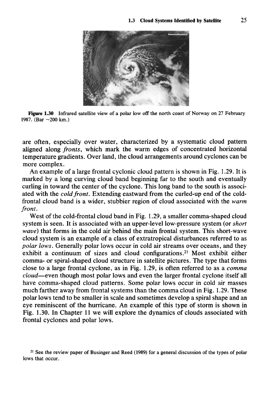
Figure 1.30 Infrared satellite view of a polar low off the north coast of Norway on 27 February
1987. (Bar
-200
km.)
are often, especially over water, characterized by a systematic cloud pattern
aligned along
fronts, which mark the warm edges of concentrated horizontal
temperature gradients. Over land, the cloud arrangements around cyclones can be
more complex.
An example of a large frontal cyclonic cloud pattern is shown in Fig. 1.29.
It
is
marked by a long curving cloud band beginning far to the south and eventually
curling in toward the center of the cyclone. This long band to the south is associ-
ated with the
cold front. Extending eastward from the curled-up end of the cold-
frontal cloud band is a wider, stubbier region of cloud associated with the
warm
front.
West
ofthe
cold-frontal cloud band in Fig. 1.29, a smaller comma-shaped cloud
system is seen.
It
is associated with an upper-level low-pressure system (or short
wave)
that forms in the cold air behind the main frontal system. This short-wave
cloud system is an example of a class of extratropical disturbances referred to as
polar lows. Generally polar lows occur in cold air streams over oceans, and they
exhibit a continuum of sizes and cloud configurations." Most exhibit either
comma- or spiral-shaped cloud structure in satellite pictures. The type that forms
close to a large frontal cyclone, as in Fig. 1.29, is often referred to as a
comma
cloud-even
though most polar lows and even the larger frontal cyclone itself all
have comma-shaped cloud patterns. Some polar lows occur in cold air masses
much farther away from frontal systems than the comma cloud in Fig. 1.29. These
polar lows tend to be smaller in scale and sometimes develop a spiral shape and an
eye reminiscent of the hurricane. An example of this type of storm is shown in
Fig. 1.30. In Chapter
11
we will explore the dynamics of clouds associated with
frontal cyclones and polar lows.
21 See the review paper of Businger and Reed (1989) for a general discussion of the types of polar
lows that occur.
Chapter
2 Atmospheric Dynamics
.....
the cloud messenger in air expires
...
"22
(2.1)
(2.2)
Atmospheric dynamics is the application of principles of fluid dynamics to the
earth's
atmosphere. Cloud dynamics, more specifically, is the application
ofthese
principles to the air motions in clouds and their immediate environments. This
chapter summarizes the topics from atmospheric dynamics that are most essential
to the discussions of cloud ·dynamics in Chapters
5-12.
2.1 The Basic Equations-'
2.1.1 Equation of Motion
The movement
of
air in the atmosphere is governed by
Newton's
second
law
of
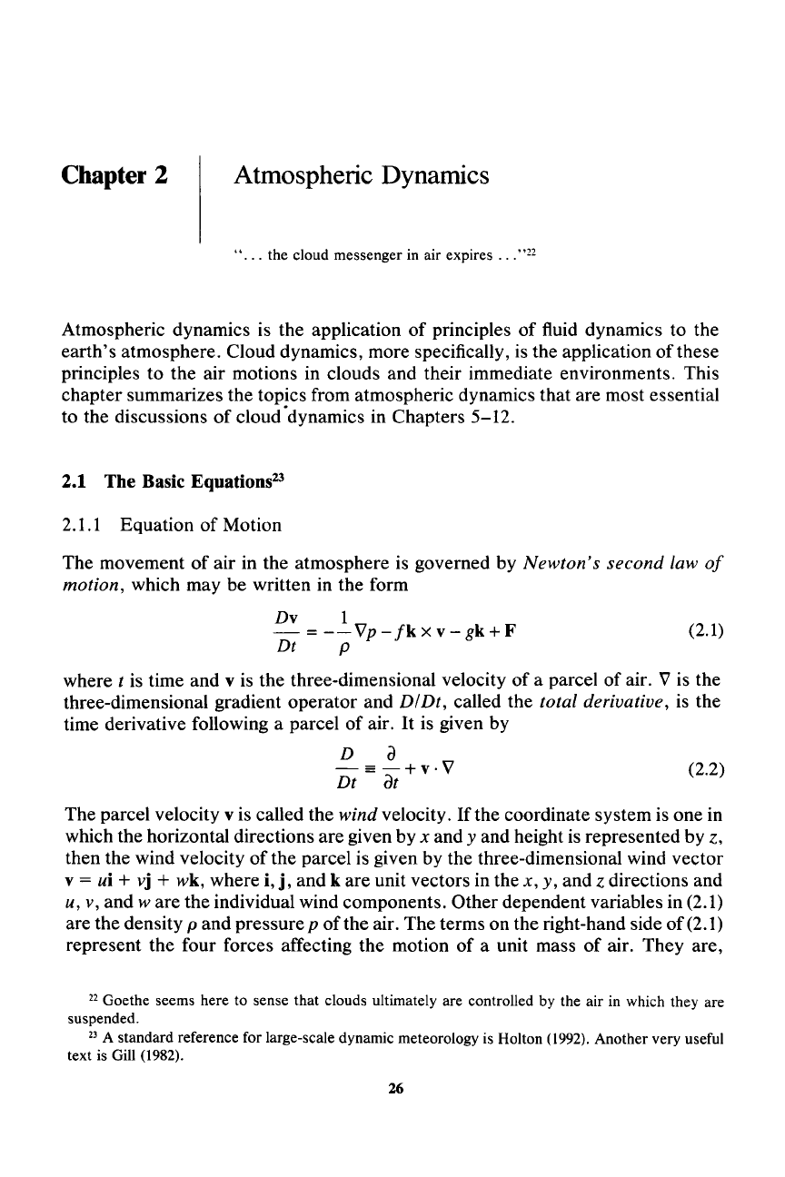
motion, which may be written in the form
Dv
1
- =
--Vp-
fk
x
v-
gk+F
Dt P
where
t is time
and
v is the three-dimensional velocity of a parcel of air. V is the
three-dimensional gradient operator and DIDt, called the total derivative, is the
time derivative following a parcel of air.
It
is given by
D a
-=-+v·V
Dt
at
The parcel velocity v is called the wind velocity. If the coordinate system is one in
which the horizontal directions are given by
x and y and height is represented by z,
then the wind velocity of the parcel is given by the three-dimensional wind vector
v
= ui + vj + wk, where i,
j,
and k are unit vectors in the x, y, and z directions and
u, v, and
ware
the individual wind components. Other dependent variables in (2.1)
are the density
p
and
pressure p
of
the air. The terms on the right-hand side of (2.1)
represent the four forces affecting the motion of a unit mass of air. They are,
22 Goethe seems here to sense that clouds ultimately are controlled by the air in which they are
suspended.
23 A standard reference for large-scale dynamic meteorology is Holton (1992). Another very useful
text is Gill (1982).
26
2.1 The Basic Equations 27
respectively, the pressure-gradient, Coriolis, gravitational, and frictional acceler-
ations.
The
quantity g is the magnitude of the gravitational acceleration,
whilefis
the Coriolis parameter
211
sin
<1>,
where
11
is the angular speed of the earth's
rotation and
<I>
is latitude.
2.1.2 Equation of State
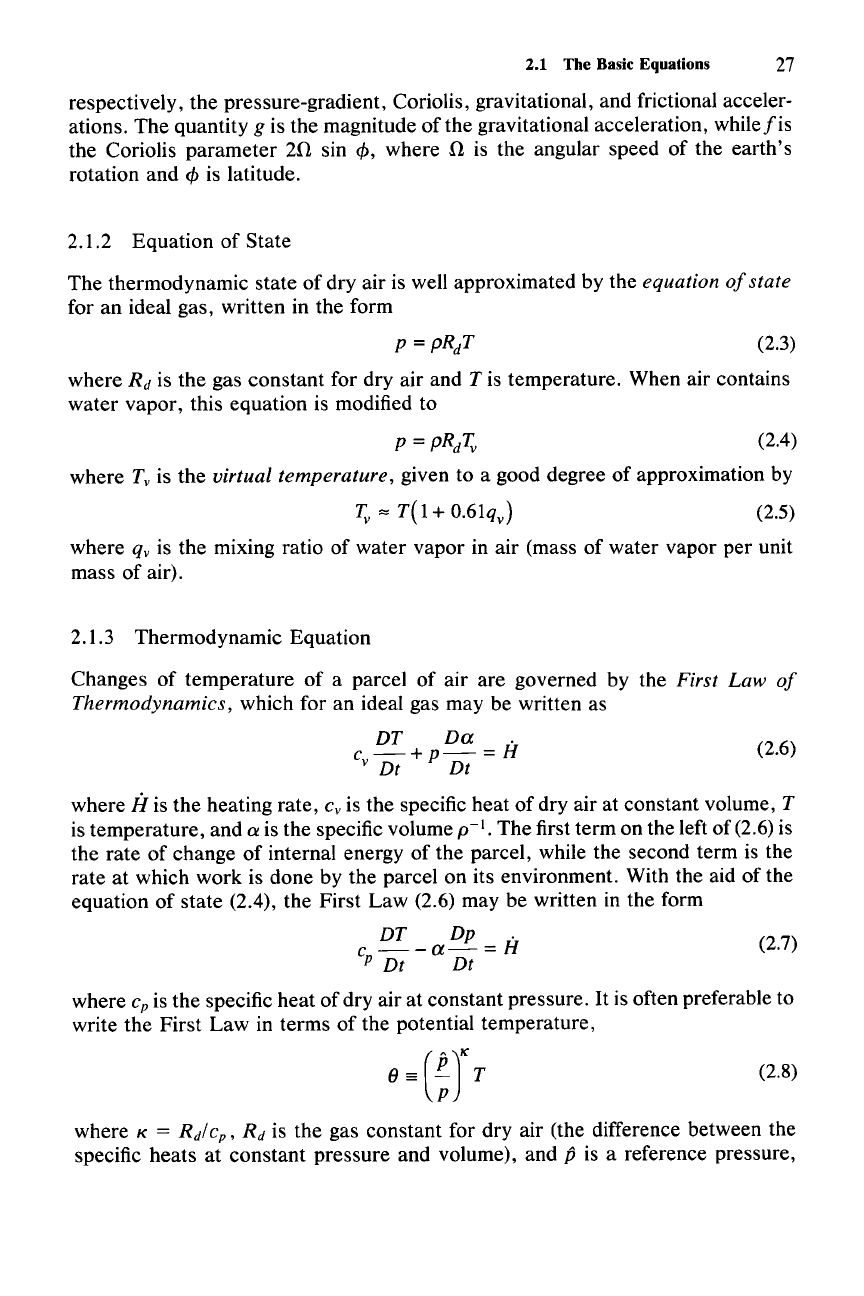
The thermodynamic state of dry air is well approximated by the equation
of
state
for an ideal gas, written in the form
(2.3)
(2.6)
where
R
d
is the gas constant for dry air and T is temperature. When air contains
water vapor, this equation is modified to
p=pRdTv (2.4)
where Tv is the virtual temperature, given to a good degree of approximation by
Tv
"" T( 1+
O.61qv)
(2.5)
where qv is the mixing ratio of water vapor in air (mass of water vapor per unit
mass of air).
2.1.3 Thermodynamic Equation
Changes of temperature
of
a parcel of air are governed by the First
Law
of
Thermodynamics, which for an ideal gas may be written as
DT
Dtx .
c
-+p-=H
v Dt Dt
where
if
is the heating rate, c, is the specific heat of dry air at constant volume, T
is temperature, and a is the specific volume
p-I.
The first term on the left of (2.6) is
the rate of change
of
internal energy of the parcel, while the second term is the
rate at which work is done by the parcel on its environment. With the aid of the
equation of state (2.4), the First
Law
(2.6) may be written in the form
DT
Dp .
c
--a-
= H (2.7)
P Dt Dt
where c
p
is the specific heat of dry air at constant pressure.
It
is often preferable to
write the First
Law
in terms of the potential temperature,
(2.8)
where K = R
d
/ c
p
,
R
d
is the gas constant for dry air (the difference between the
specific heats at constant pressure and volume), and
p is a reference pressure,
28 2 Atmospheric Dynamics
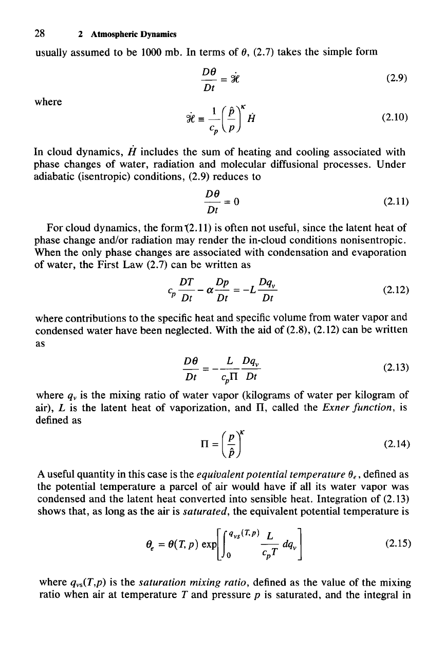
usually assumed to be 1000 mb. In terms of
(),
(2.7) takes the simple form
DO
.
-=
'Je
Dt
(2.9)
(2.10)
where
~=:p(~rH
In cloud dynamics,
iI
includes the sum of heating and cooling associated with
phase changes of water, radiation and molecular diffusional processes. Under
adiabatic (isentropic) conditions,
(2.9) reduces to
(2.11)
DO
-=0
Dt
For
cloud dynamics, the form '(2.11) is often not useful, since the latent heat of
phase change and/or radiation may render the in-cloud conditions nonisentropic.
When the only phase changes are associated with condensation and evaporation
of water, the First Law (2.7) can be written as
DT
Dp Dqv
c
--a-=-L--
p Dt Dt Dt
(2.12)
where contributions to the specific heat and specific volume from water vapor and
condensed water have been neglected. With the aid of (2.8), (2.12) can be written
as
(2.13)
DO
L Dqv
=-----
Dt
cpTI
Dt
where qy is the mixing ratio of water vapor (kilograms of water per kilogram of
air),
L is the latent heat of vaporization, and
TI,
called the
Exner
function,
is
defined as
(2.14)
A useful quantity in this case is the
equivalent
potential
temperature
(}e, defined as
the potential temperature a parcel of air would have if all its water vapor was
condensed and the latent heat converted into sensible heat. Integration of (2.13)
shows that, as long as the air is
saturated,
the equivalent potential temperature is
(2.15)
where
qys(T,p) is the
saturation
mixing
ratio, defined as the value of the mixing
ratio when air at temperature
T and pressure p is saturated, and the integral in
