Houze Robert A., Jr. Cloud Dynamics
Подождите немного. Документ загружается.

1.2 Cloud Types Identified Visually 9
shower of rain. Since it rains, the towering cumulus designation changes to cumu-
lonimbus. At higher latitudes, an anvil shape may not be seen at the upper levels
of a precipitating cumuliform cloud if the wind shear in the environment of the
cloud is weak, even if the upper portion of the cloud is composed of ice particles.
1.2.2.2 Stratiform Clouds
Fog is generally any cloud whose base touches the ground. Thus, any type of
cloud intersecting a hill or mountain would be reported as fog by an observer on
the portion of the hill enshrouded by cloud, while an observer located below the
base of the cloud would identify the cloud by one of the 10 genera listed in Table
1.1. What we will consider to be a true fog occurs as a result of the air being in
contact with the ground and as such is not described in terms of one of the 10
genera. As will be discussed in Chapter 5, the most common and widespread types
of fog form when a layer of air is in contact with a cold surface. Radiation fog
occurs when the underlying surface has cooled by infrared radiation.
It
forms
under very calm conditions, as the turbulence associated with any wind would
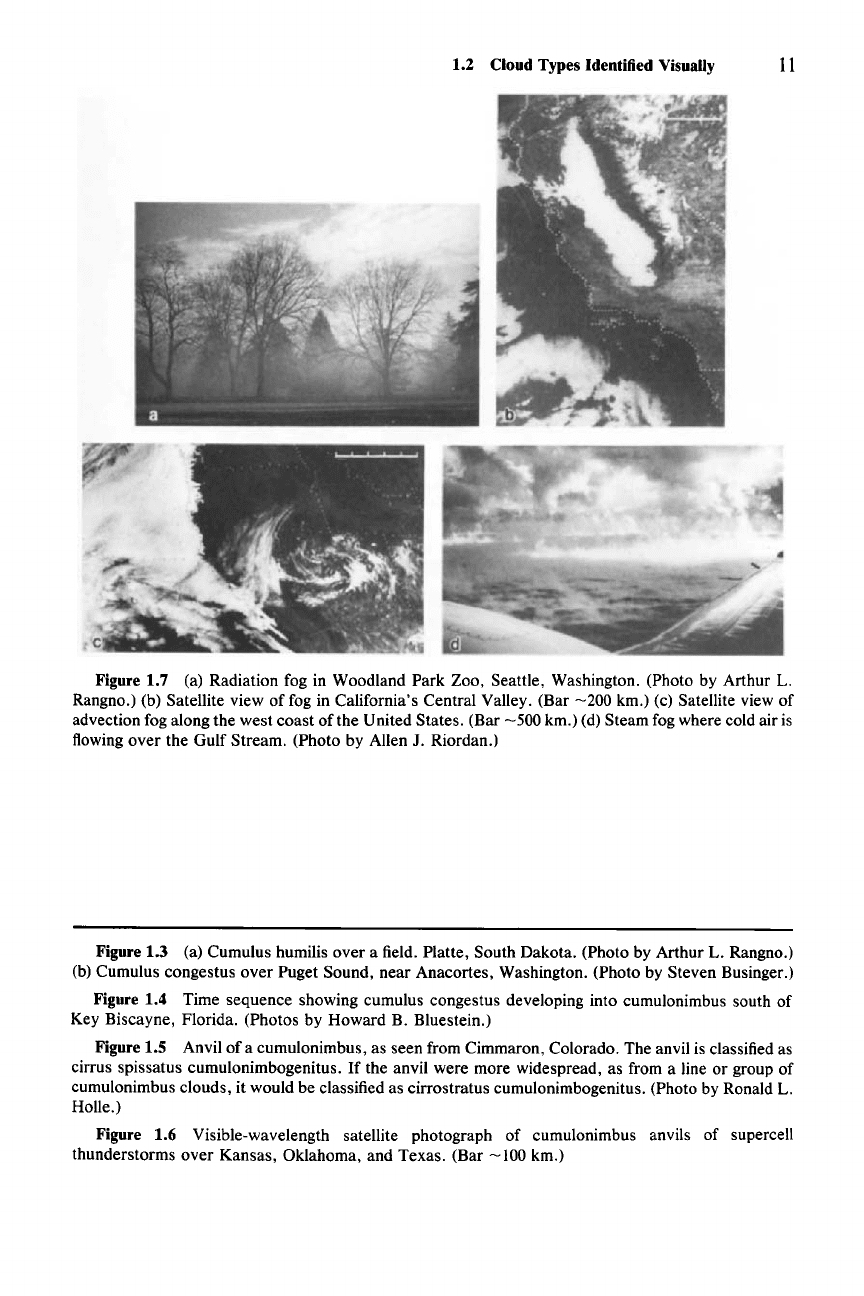
destroy the fog. An example of radiation fog is shown in Fig. 1.7a. Radiation fog
may be quite widespread, covering mesoscale or synoptic-scale regions of the
earth (e.g., fog is seen covering the entire Central Valley of California in Fig.
1.7b). Advection
fog
forms when warm air moves over a pre-existing cold surface
(Fig. 1.7c). Steam
fog
forms when cold air is over warm water and a turbulent
steam rises from the water surface (Fig. 1.7d).
Stratus comprises a "generally grey cloud layer with a fairly uniform base,
which may give drizzle, ice prisms, or snow grains. When the sun is visible
through the cloud, its outline is clearly discernible
....
Sometimes stratus appears
in the form of ragged
patches."
This type of cloud is difficult to observe com-
pletely from the ground because it is often so horizontally extensive that it lies like
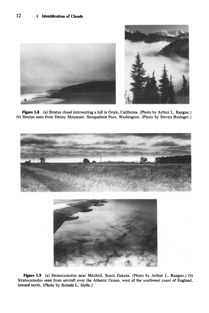
a blanket overhead, so that it is impossible to see the top or sides of the cloud (Fig.
1.8a). When viewed from above, as in Fig. 1.8b, and the sun is not blocked by
middle or high clouds, the top of the cloud may be brilliantly white, in contrast to
its grayish cast when viewed from underneath. Stratus is generally not a thick
cloud
(::51
km), as indicated by the fact that the outline of the sun is typically
visible through it.
Stratocumulus refers to a
"grey
or whitish, or both grey and whitish, patch,
sheet, or layer of cloud which almost always has dark parts, composed of tessella-
tions, rounded masses, rolls, etc., which are nonfibrous (except for virga) and
which
mayor
may not be merged; most of the regularly arranged small elements
usually have an apparent width of more than five degrees." This type of cloud is
often very similar to stratus in that it is a low overhanging blanket of cloud.
It
is
distinguishable from stratus in that it has clearly identifiable elements (Fig. 1.9a).
Viewed from an aircraft, stratocumulus sometimes appears as a mosaic of clumps
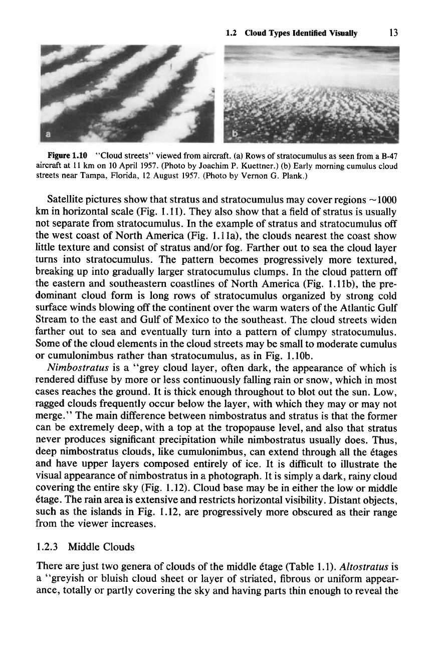
(Fig. 1.9b), while at other times it exhibits tessellations or rolls, called cloud
streets (Fig. 1.lOa). The cloud streets can be quite long, and the individual cloud
elements in the streets can become more vigorous and take the form of small to
moderate cumulus (Fig. 1.lOb).

10 1 Identification of Clouds
Figure 1.3
Figure
1.4
Figure 1.5
Figure 1.6
1.2 Cloud Types Identified
VisuaUy
11
Figure 1.7 (a) Radiation fog in Woodland Park Zoo, Seattle, Washington. (Photo by Arthur L.
Rangno.) (b) Satellite view of fog in California's Central Valley. (Bar
-200
km.) (c) Satellite view of
advection fog along the west coast of the United States. (Bar
-500
km.) (d) Steam fog where cold airis
flowing over the Gulf Stream. (Photo by Allen
J. Riordan.)
Figure 1.3 (a) Cumulus humilis over a field. Platte, South Dakota. (Photo by Arthur L. Rangno.)
(b) Cumulus congestus over Puget Sound, near Anacortes, Washington. (Photo by Steven Businger.)
Figure 1.4 Time sequence showing cumulus congestus developing into cumulonimbus south of
Key Biscayne, Florida. (Photos by Howard B. Bluestein.)
Figure 1.5 Anvil
ofa
cumulonimbus, as seen from Cimmaron, Colorado. The anvil is classified as
cirrus spissatus cumulonimbogenitus. If the anvil were more widespread, as from a line or group of
cumulonimbus clouds, it would be classified as cirrostratus cumulonimbogenitus. (Photo by Ronald
L.
Holle.)
Figure 1.6 Visible-wavelength satellite photograph of cumulonimbus anvils of supercell
thunderstorms over Kansas, Oklahoma, and Texas. (Bar
-100
km.)
12 1 Identification of Clouds
Figure 1.8
(a) Stratus cloud intersecting a hill in Orick, California. (Photo by Arthur
L.
Rangno.)
(b) Stratus seen from Denny Mountain. Snoqualmie Pass, Washington. (Photo by Steven Businger.)
Figure 1.9 (a) Stratocumulus near Mitchell, South Dakota. (Photo by Arthur L. Rangno.) (b)
Stratocumulus seen from aircraft over the Atlantic Ocean, west of the southwest coast of England,
toward north. (Photo by Ronald
L. Holle.)
1.2 Cloud Types Identified Visually
13
Figure 1.10 "Cloud streets" viewed from aircraft. (a) Rows of stratocumulus as seen from a 8-47
aircraft at 11 km on 10 Apri11957. (Photo by Joachim P. Kuettner.) (b) Early morning cumulus cloud
streets near Tampa, Florida, 12 August 1957. (Photo by Vernon G. Plank.)
Satellite pictures show that stratus and stratocumulus may cover regions
~
1000
km in horizontal scale (Fig. 1.11). They also show that a field of stratus is usually
not separate from stratocumulus. In the example of stratus and stratocumulus off
the west coast of North America (Fig.
I.IIa),
the clouds nearest the coast show
little texture and consist of stratus and/or fog. Farther out to sea the cloud layer
turns into stratocumulus. The pattern becomes progressively more textured,
breaking up into gradually larger stratocumulus clumps. In the cloud pattern off
the eastern and southeastern coastlines of North America (Fig. 1.11b), the pre-
dominant cloud form is long rows of stratocumulus organized by strong cold
surface winds blowing off the continent over the warm waters of the Atlantic Gulf
Stream to the east and Gulf of Mexico to the southeast. The cloud streets widen
farther out to sea and eventually turn into a pattern of clumpy stratocumulus.
Some
ofthe
cloud elements in the cloud streets may be small to moderate cumulus
or cumulonimbus rather than stratocumulus, as in Fig. 1.lOb.
Nimbostratus is a
"grey
cloud layer, often dark, the appearance of which is
rendered diffuse by more or less continuously falling rain or snow, which in most
cases reaches the ground.
It is thick enough throughout to blot out the sun. Low,
ragged clouds frequently occur below the layer, with which they
mayor
may not
merge." The main difference between nimbostratus and stratus is that the former
can be extremely deep, with a top at the tropopause level, and also that stratus
never produces significant precipitation while nimbostratus usually does. Thus,
deep nimbostratus clouds, like cumulonimbus, can extend through all the etages
and have upper layers composed entirely of ice.
It is difficult to illustrate the
visual appearance of nimbostratus in a photograph.
It
is simply a dark, rainy cloud
covering the entire sky (Fig. 1.12). Cloud base may be in either the low or middle
etage. The rain area is extensive and restricts horizontal visibility. Distant objects,
such as the islands in Fig. 1.12, are progressively more obscured as their range
from the viewer increases.
1.2.3 Middle Clouds
There are
just
two genera of clouds of the middle etage (Table 1.1). Altostratus is
a "greyish or bluish cloud sheet or layer of striated, fibrous or uniform appear-
ance, totally or partly covering the sky and having parts thin enough to reveal the
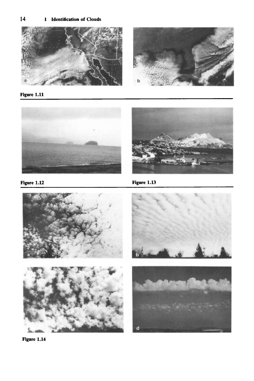
14 1 Identification of Clouds
Figure 1.11
Figure 1.12
Figure 1.14
Figure 1.13
1.2 Cloud Types Identified Visually 15
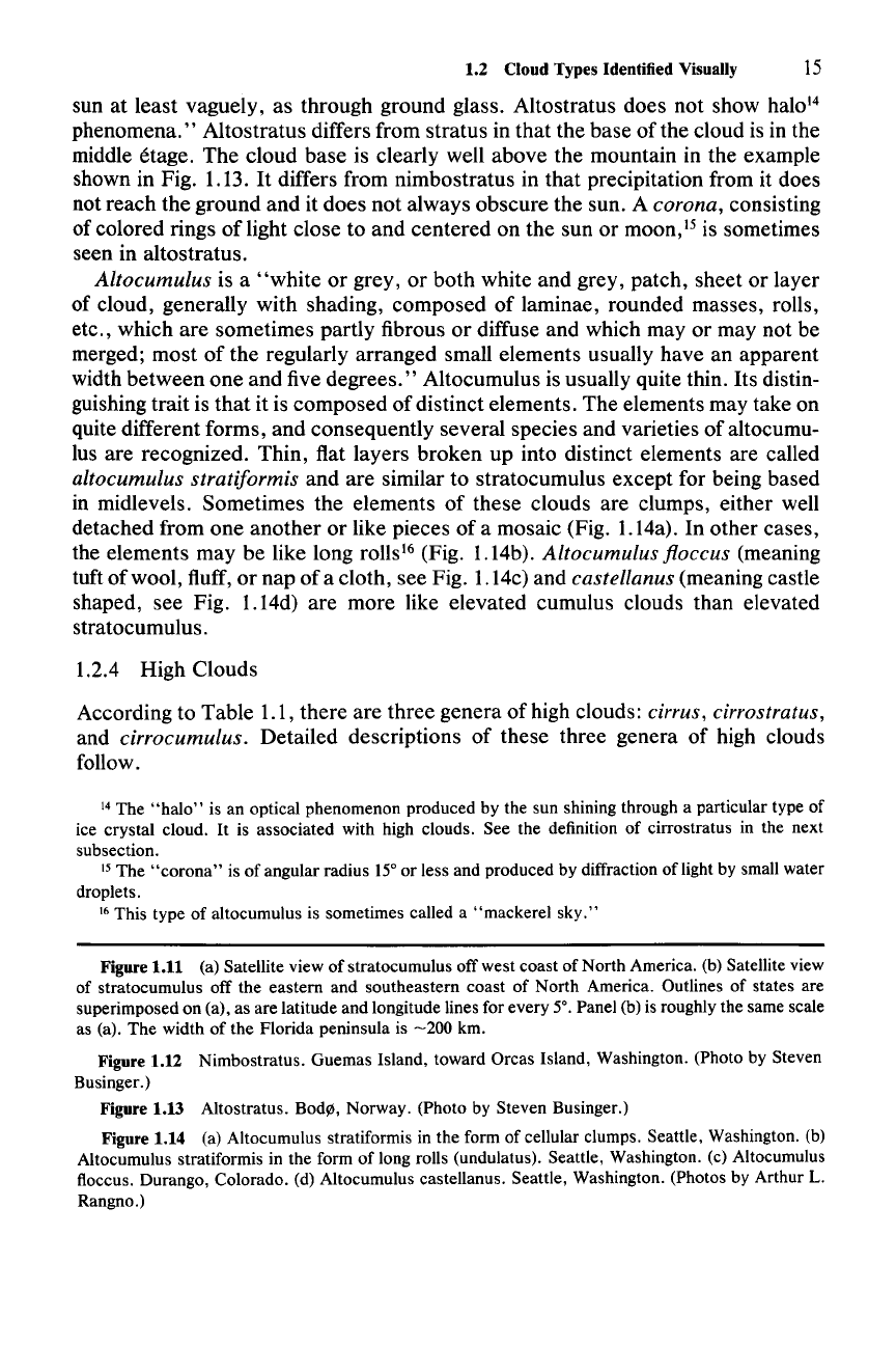
sun at least vaguely, as through ground glass. Altostratus does not show halo!'
phenomena." Altostratus differs from stratus in that the base of the cloud is in the
middle etage. The cloud base is clearly well above the mountain in the example
shown in Fig. 1.13. It differs from nimbostratus in that precipitation from it does
not reach the ground and it does not always obscure the sun. A
corona, consisting
of colored rings of light close to and centered on the sun or
moon," is sometimes
seen in altostratus.
Altocumulus is a
"white
or grey, or both white and grey, patch, sheet or layer
of cloud, generally with shading, composed of laminae, rounded masses, rolls,
etc., which are sometimes partly fibrous or diffuse and which
mayor
may not be
merged; most
of
the regularly arranged small elements usually have an apparent
width between
one
and five degrees." Altocumulus is usually quite thin. Its distin-
guishing trait is that it is composed of distinct elements. The elements may take on
quite different forms, and consequently several species and varieties of altocumu-
lus are recognized. Thin, flat layers broken up into distinct elements are called
altocumulus stratiformis and are similar to stratocumulus except for being based
in midlevels. Sometimes the elements of these clouds are clumps, either well
detached from
one
another or like pieces of a mosaic (Fig. 1.14a). In other cases,
the elements may be like long rolls'? (Fig. 1.14b).
Altocumulus floccus (meaning
tuft of wool, fluff, or nap of a cloth, see Fig. 1.14c) and
castellanus (meaning castle
shaped, see Fig. 1.14d) are more like elevated cumulus clouds than elevated
stratocumulus.
1.2.4 High Clouds
According to Table 1.1, there are three genera of high clouds:
cirrus, cirrostratus,
and cirrocumulus. Detailed descriptions of these three genera of high clouds
follow.
14 The
"halo"
is an optical phenomenon produced by the sun shining through a particular type of
ice crystal cloud.
It
is associated with high clouds. See the definition of cirrostratus in the next
subsection.
15 The
"corona"
is of angular radius 15°or less and produced by diffraction of light by small water
droplets.
16 This type of altocumulus is sometimes called a "mackerel
sky."
Figure 1.11 (a) Satellite view of stratocumulus off west coast of North America. (b) Satellite view
of stratocumulus off the eastern and southeastern coast of North America. Outlines of states are
superimposed on (a), as are latitude and longitude lines for every 5°. Panel (b) is roughly the same scale
as (a). The width of the Florida peninsula is
-200
km.
Figure 1.12 Nimbostratus. Guemas Island, toward Orcas Island, Washington. (Photo by Steven
Businger.)
Figure 1.13 Altostratus. Bode, Norway. (Photo by Steven Businger.)
Figure 1.14 (a) Altocumulus stratiformis in the form of cellular clumps. Seattle, Washington. (b)
Altocumulus stratiformis in the form of long rolls (undulatus). Seattle, Washington. (c) Altocumulus
floccus. Durango, Colorado. (d) Altocumulus castellanus. Seattle, Washington. (Photos by Arthur L.
Rangno.)
16 1 Identification of Clouds
Cirrus consists of
"detached
clouds in the form of white, delicate filaments or
white or mostly white patches or narrow bands. These clouds have a fibrous (hair-
like) appearance, or a silky sheen, or
both."
Cirrostratus is a "transparent, whitish cloud veil of fibrous (hair-like) or
smooth appearance, totally or partly covering the sky, and generally producing
halo'? phenomena."
Cirrocumulus is a
"thin
white patch, sheet or layer of cloud without shading,
composed of very small elements in the form of grains, ripples, etc., merged or
separate, and more or less regularly arranged; most of the elements have an
apparent width of less than one degree."
Examples of these three types of high cloud are shown in Fig. 1.15. The panels
of the figure are arranged in order of stage of life cycle of the cirriform cloud. The
layer of cloud in Fig. 1.15a is cirrocumulus. Individual cloud elements in the form
of both grains and ripples can be seen. The cloud elements have a relatively solid,
nonfibrous appearance compared to the forms of cirrus shown in Fig. 1.15b-d.
This solid appearance is characteristic of cirrus elements in an early stage of
development. Upward air currents in the elements are in the process of producing
the ice particles, or very briefly, water droplets, which compose the elements. As
the cloud ages, it takes on a progressively more diffuse and fibrous appearance.
Cirrocumulus is the high-cloud counterpart of altocumulus, and
it has species
and varieties similar to those of altocumulus. The example in Fig. 1.15a is
cirro-
cumulus stratiformis.
Cloud elements in the form of cellular grains and undular
ripples are both evident in this cloud layer. Cirrocumulus ripples are also seen in
the upper left-hand portion of Fig. 1.19. The grains and ripples in these cirrocumu-
lus patterns correspond to the cellular and roll structures seen in altocumulus
stratiformis in Fig. 1.14a and b.
Cirriform clouds consist almost entirely of ice particles. Many of the individual
particles become sufficiently large, and the saturation vapor pressure of ice is
sufficiently low, that the particles composing the clouds evaporate slowly. The
strong winds at high levels can therefore advect the particles great distances, thus
giving cirrus clouds a characteristically stringy or hair-like appearance, which
becomes more exaggerated as the clouds age. The clouds in Fig. 1.15b are
cirrus
floccus.
Similar in appearance to the altocumulus floccus seen in Fig. 1.14c, they
represent a slightly more advanced stage of cirrus development, in which solid,
crisply formed elements, such as those seen in the cirrocumulus in Fig. 1.15a,
have weakened and started to become diffuse and fibrous, although vestiges of
their earlier clumpy structure remain evident. Slowly evaporating ice particles are
beginning to be swept away from the dissipating clumps. The long strands of
cirrus with a hook at their upwind ends seen in Fig. 1.15c are called
cirrus uncinus
(which is the word for hooked in Latin). They represent a more advanced stage of
development than that of the cirrus floccus seen in Fig. 1.15b. In this case the cell
17 The
"halo"
is a bright circle of angular radius 8°, 22°, or 46° surrounding the sun.
It
is produced
by the refraction of sunlight in hexagonal prisms of ice. The 22° halo is the most common.
For
an
explanation of the phenomenon, see Wallace and Hobbs (1977, Figs. 5.7 and 5.8).
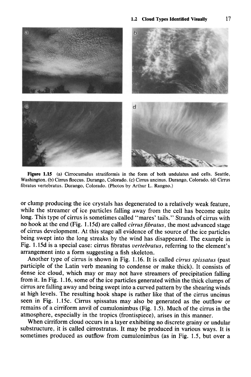
1.2 Cloud Types Identified Visually 17
Figure 1.15 (a) Cirrocumulus stratiformis in the form of both undulatus and cells. Seattle,
Washington. (b) Cirrus floccus. Durango, Colorado. (c) Cirrus uncinus. Durango, Colorado. (d) Cirrus
fibratus vertebratus. Durango, Colorado. (Photos
by Arthur L. Rangno.)
or clump producing the ice crystals has degenerated to a relatively weak feature,
while the streamer of ice particles falling away from the cell has become quite
long. This type of cirrus is sometimes called
"mares'
tails." Strands of cirrus with
no hook at the end (Fig. 1.15d) are called
cirrus fibratus, the most advanced stage
of cirrus development. At this stage all evidence of the source of the ice particles
being swept into the long streaks by the wind has disappeared. The example in
Fig. 1.15d is a special case: cirrus fibratus
vertebratus, referring to the element's
arrangement into a form suggesting a fish skeleton.
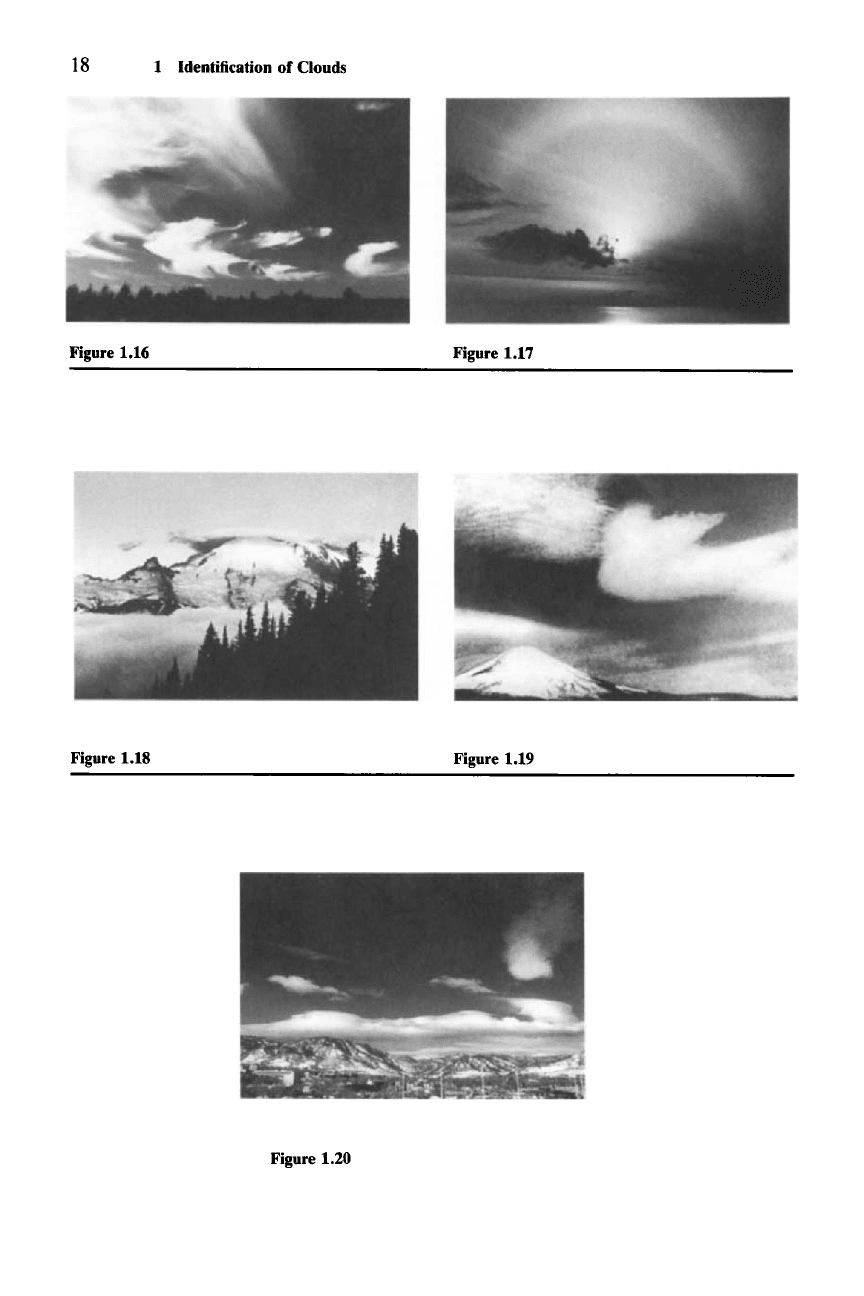
Another type of cirrus is shown in Fig. 1.16.
It
is called cirrus spissatus (past
participle of the Latin verb meaning to condense or make thick).
It
consists of
dense ice cloud, which
mayor
may not have streamers of precipitation falling
from it. In Fig. 1.16, some of the ice particles generated within the thick clumps of
cirrus are falling away and being swept into a curved pattern by the shearing winds
at high levels. The resulting hook shape is rather like that of the cirrus uncinus
seen in Fig. 1.15c. Cirrus spissatus may also be generated as the outflow or
remains of a cirriform anvil of cumulonimbus (Fig. 1.5). Much of the cirrus in the
atmosphere, especially in the tropics (frontispiece), arises in this manner.
When cirriform cloud occurs in a layer exhibiting no discrete grainy or undular
substructure, it is called cirrostratus.
It
may be produced in various ways.
It
is
sometimes produced as outflow from cumulonimbus (as in Fig. 1.5, but over a
18 1 Identification of Clouds
Figure 1.16 Figure 1.17
Figure 1.18 Figure 1.19
Figure 1.20
