Daniel E. Williams. Sustainable Design. Ecology, architecture and planning. (анг. яз)
Подождите немного. Документ загружается.


REGIONAL CASE STUDIES 61
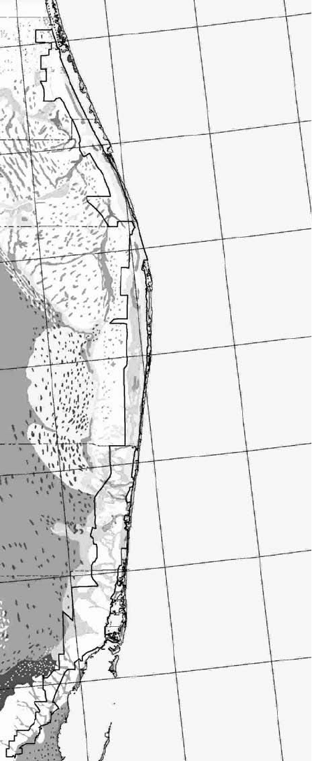
Predevelopment Pattern.
Florida presettlement
water features and
vegetation patterns.

glades wetlands, valuable coastal marshes, and critical recharge areas for public well
fields. Continued development within these areas, which is the present-day pattern,
will cause more local flooding, eliminate critical aquifer recharge areas, and destroy
valuable natural resources.
Given the limited land area suitable for development and the water resource
limits of South Dade County, how do we create a system that will ensure the viabil-
ity and hydrology—and our knowledge of their interactive connections? We can re-
create the historic hydrologic functions of the region.
This systems approach, illustrated in the Sustainable South Dade vision, is
designed to use the free work of nature to sustainably collect, store, clean up, and
distribute water for all users—urban, agricultural, and natural systems.
The Smart-Growth Vision (page 65) shows the drainage canals replaced by
broad wetland systems similar to what was historically the transverse glades. These
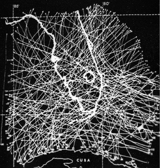
Hurricane pathways,
1889–1989 (South
Florida Water
Management District).
62 SUSTAINABLE DESIGN

REGIONAL CASE STUDIES 63
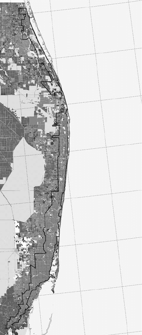
The 2024 built-out areas
showing growth
continuing the same as
now. This will create
sprawl, flooding, loss of
agriculture, loss of
potable water, and auto
gridlock.

topographic low points are an integral part of the region’s natural flood protection.
The north-south canal, separating the developed part of Dade County from the
Everglades, is expanded to provide valuable storage and cleansing of water. This will
improve the quality of water while preserving a sustainable water supply for future
users. The coastal canals become spreader canals to enhance the distribution, tim-
ing, quantity, and quality of the water that flows to Biscayne Bay while protecting
the biological food chain and supporting sport fishing and ecotourism.
On the Smart-Growth Vision illustration (page 65) the light squares to the west
represent subregional wastewater treatment plants that will provide for 100 percent
reuse of the waste effluent. This requires enhanced water-quality treatment, pro-
vided by natural cleansing of the water in the newly created wetland areas. By recy-
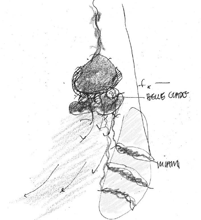
A regional-systems sketch
illustrating the creation
of areas for agriculture,
water recharge, livable
communities, and
transit-oriented
development.
64 SUSTAINABLE DESIGN

REGIONAL CASE STUDIES 65
Smart-Growth Vision. This is a stakeholder-based vision that illustrates sustainable land-use patterns, agricultural
protections, sustainable potable-water storages, and improved quality of life. The vision drawing, informed by the
hydrology and ecology, is necessary to answer the question: What kind of tomorrow are we leaving our children?
cling this water to the aquifer, much of the water that is consumed every day will be
replenished within 48 hours of use.
In this plan, open, pervious land uses that provide valuable recharge to the
aquifer are preserved. This will also provide for the preservation of the agriculture and
quality of life that exists in the Redland today. To support this objective, development
should occur on the higher ground of the coastal ridge. Mass transit and community-
based transit centers should be located within the developed areas. These locations,
due to their size and strategic location for flood and storm protection, will encourage
the development of tightly knit communities with strong regional connections and
will reinforce the opportunity to provide for future water needs.
The bioregional and biourban processes incorporate the following:
1. Researching and understanding the ecological, social, regional, or geographical
systems at a scale larger than the project scale (bioregionalism).
2. Applying this bioregional knowledge to the way in which the interaction of the
urban components—specifically, infrastructure, utilities, and neighborhood pat-
terns—are designed.
3. Incorporating the free work of natural systems—ecology, biology, physics, cli-
mate, hydrology, and soils—by using natural processes rather than technologi-
cal processes for water storage and cleaning, microclimate control and resource
use, and reuse and recycling.
4. Designing the connections to make use of this free work (biourbanism).
Process changes in planning and design can have the largest positive impact on
environmental protection. Incorporating an understanding of the functional aspects
of and information embodied within natural systems into urban and regional plan-
ning practices assures a valuable reconnection to the lessons of history.
Seize the Moment
On August 24, 1992, in the aftermath of Hurricane Andrew, the opportunity arose
to use a watershed approach as a critical element in the rebuilding effort in south
Florida. This adversity-to-opportunity approach seeks to successfully integrate
future land-use development and natural-resource protection by preserving, pro-
tecting, and—when necessary—reestablishing the natural system connections on a
regional scale. Watershed planning would become the conceptual foundation for
the local, state, and federal planning initiatives on growth and sprawl all connected
to the need for potable-water and natural-resource protection rather than arbitrary
lines on a county map.
The watershed plan has three objectives:
1. Provide a comprehensive understanding of the relationships between land use
and regional water-management objectives.
2. Build consensus among local, state, and federal interests as to the actions nec-
essary to achieve regional water-management objectives.
66 SUSTAINABLE DESIGN

3. Select a hydrologic basin within the watershed for future study and for the
development of future demonstration projects.
Without smart planning, an additional million people will pave over an addi-
tional 21 square miles of the remaining pervious soil area. That would result in the
loss of 21 square miles of recharge area that once received, stored, and distributed
water to sustain the regional water budget. Use of water without recharge is not
sustainable. More importantly, a region’s or locale’s water budget is truly defined by
access to a sustainable and continuous supply. Water budgets that include use of the
huge storages from an aquifer are not budgets that can be sustained. To use an eco-
nomic analogy, this is similar to living off the principal rather than the interest.
Design of the area greenways will take many forms and sizes. The size will
depend on the pollutant loading of the land used within the watershed draining into
the canal. These greenways will also serve as habitat for various species. They will
encompass diverse pathways that will be rich in function and will include lineal
parks, greenways, and bike paths and will provide local flood protection. At the
coastal zone, canals would no longer flow directly into Biscayne Bay but through an
archipelago of sorts. Diverting the flow and creating upstream storages will enhance
the water quantity and quality. Simultaneously, considerably more area for water
recharge as well as for aquatic food chain nursery grounds will be created.
This new edge condition in the urban segment, where the canal and littoral
meet in a land-aquatic transition zone, would create an identity and image for the
community while increasing flood protection and neighborhood open-space ameni-
ties. The combined water-storage areas and open spaces not only help define better
neighborhoods but also increase property values.
The agricultural areas remain defined by the area water regime, or rainfall pat-
tern; reverse flooding irrigation would use less water and control nematodes and
other pests while rebuilding the soil and reducing evaporation.
Conclusion
With regional and community participation, the county’s urban and regional water-
shed plan maps out a vision for the future: to establish and protect water-recharge
areas, to provide clean water, and to develop the incremental steps toward smart
growth. The design calls for future development in urban infill sites in safe and appro-
priate locations. In this design, sewage treatment plants are strategically located to
recycle and reuse water and nutrients; hydric neighborhood parks are designed to
store, clean up, and distribute water, adding to potable recharge and community open
space for the same tax dollars; and development is stepped back from the region’s net-
work of canals to reverse the trespass on wetlands and improve flood protection.
This vision anticipates regional population growth of an additional 700,000 peo-
ple, while providing environmental stewardship, smart-growth boundaries, walkable
communities, water recharge parks, sewage reclamation, an energy-conscious urban
plan and design, and development that relies more on transit than on individual cars.
REGIONAL CASE STUDIES 67
“My primary interest is get-
ting everybody to under-
stand the larger picture and
have a greater understand-
ing of how natural systems
work so that they’ll make
better decisions. When peo-
ple are actually involved,
they do see the larger pic-
ture. In fact, that is how
they get to see the larger
picture.”
ADELHEID FISCHER, “COMING
FULL CIRCLE: THE
RESTORATION OF THE URBAN
LANDSCAPE,” IN ORION:
PEOPLE AND NATURE
(AUTUMN 1994): 29.
The 20-year program is likely to cost $7 billion to $8 billion, mostly for land pur-
chases, which is a bargain compared to engineering solutions such as pumping or
desalinization.
The watershed design approach recreates many successful connections:
䊏
Protection of natural-system functioning within regional and urban green-
ways increases the value of adjacent properties while providing for regional
recharge.
䊏
Storing water within these hydric green- and blueways will increase water
supplies for future use and is the most effective way of increasing potable
water storage while rendering the bonus of community open space.
䊏
Preservation and protection of parks and conservation areas within the urban
and regional pattern provides critical livability, health, and economy to the
entire region.
䊏
Water management is integrated with land-use decisions based on supply
and population, the natural carrying capacity.
䊏
Ecosystem management and watershed planning simultaneously address the
complex issues of urban quality of life and preservation of natural systems.
䊏
Community members and other stakeholders develop a common vision that
promotes community cohesiveness.
The economic value of this smart-growth plan is quite impressive. The following
savings (1999 figures) are directly attributable to sustainable regional watershed
planning and design—Smart Growth:
䊏
67,725 acres of developable land
䊏
13,887 acres of fragile environmental lands
䊏
52,856 acres of prime farmland
䊏
4,221 lane miles of local roads
䊏
$62,000,000 in state road costs
䊏
$1,540,000 in local road costs
䊏
$157,000,000 in water capital costs
䊏
$135,600,000 in sewer capital costs
䊏
$24,250,000 savings per year in public-sector service costs
(Source: 1999, Center for Urban Policy Research, Rutgers University, New
Brunswick, New Jersey)
Design Team
Daniel Williams, Director
Brian Sheahan, Correa, Valle, Valle
68 SUSTAINABLE DESIGN

CHAPTER FOUR
sustainable urban and
community design
The materials of city planning are sky, space, trees, steel, and cement—in that
order and that hierarchy.
—Le Corbusier
T
he idea of community is central to ecology. The materials and energies that con-
stitute ecology create the form and pattern of the community, and these con-
stituent elements are characteristics of the community’s scale and size. The form and
pattern are derived from the mobility of the resident organisms and their ability to
feed, breed, rest, and nest within the area. A community of anything is a sum total
of all elements working simultaneously. Community, in the truest sense of the word,
is an organism—that is, “a complex structure of interdependent and subordinate
elements whose relations and properties are largely determined by their function in
the whole” (per Merriam-Webster’s Collegiate Dictionary, 11th edition).
Much of the current thinking in urban and community design focuses on the
form of neighborhood and community. In these projects, many important objectives
are stressed: walkable neighborhoods; small-scale streets; good edge definition,
design, and location of town and neighborhood centers; transportation; and
community gathering places. However, long-term sustainability is not achievable in
these communities, as they rely almost entirely on nonrenewable energy. No matter
how charming the pattern, any biological community, including the human commu-
nity, must tie its long-term development and use to the sustainable energies and
resources that are resident to the place.
The history of settlements has shown that resources sustain communities and
the people within them. When resources dry up, so do communities. A sustainable
urban and community pattern comes from understanding and connecting and
“The world is full of quaint
ghost towns. The history of
urban settlements has
shown that renewable
resources sustain towns
and communities—and the
creation of a sustainable
neighborhood pattern is a
function of understanding,
connecting, and adapting to
those renewable resources.”
CONGRESS FOR NEW
URBANISM, NATIONAL
CONFERENCE 1999, PANEL ON
SUSTAINABLE DEVELOPMENT

adapting to local sustainable resources. As fossil fuel dries up, what do these new
communities look like? What is the pattern of sustainable settlements?
A Matter of Place
Each scale, or level, in the sustainable-design process is informed by what exists at
the next, larger scale. Understanding the relationship between the local use and the
regional supply of sustainable energy, for example, is a critical element in the sus-
tainable design process. There is great diversity within regional systems, although
the system characteristics fall under a specific classification.
A desert biome, for example, in the Southwest region of the United States may
have small pockets of water, but it is always a desert. The Pacific Northwest may
have areas that receive considerable sunlight, but it is generally an evergreen biome
with clouds and moisture. Urban design that approaches sustainability incorporates
the bioclimatic conditions of the region, and the patterns of the community are
informed by the microclimate of that location.
A region’s bioclimate is its character. This character includes soil, vegetation, and
animal life, which all operate on sustainable resident energy. Urban design that
approaches sustainability works by maximizing the use of this kind of resident
energy and local resources. This biological urbanism, or biourbanism, incorporates
natural systems and green processes into the urban design. Examples of these
processes are oxygen production, water storage, water purification, water distribu-
tion, microclimate cooling and heating, flood protection, water treatment, food sup-
ply, climatically derived walking distances, and job creation.
70 SUSTAINABLE DESIGN
Barcelona Declaration on Sustainable Design
Adopted at the Construmat Fair in Barcelona, Spain, May 28, 2003
1. Whereas the design of cities and buildings is responsible for the urban
metabolisms that can give rise to serious consequences for the quality of
life for human inhabitants;
2. Whereas the complexity of global ecological problems should inspire
change in the course of uncontrolled growth of the human habitat;
3. Whereas urban phenomena of crisis produce conflicts that must be stud-
ied with new criteria, using new tools and providing new approaches;
4. Whereas the architects represented by the presidents of UIA, AIA, RIBA,
and CSCAE defend and endorse the conclusions of the World Summits
of Rio de Janeiro, Istanbul, and Beijing, in favor of the world’s
sustainability;
5. Whereas the best architecture is the one that fits with the environment
and place;
