Daniel E. Williams. Sustainable Design. Ecology, architecture and planning. (анг. яз)
Подождите немного. Документ загружается.

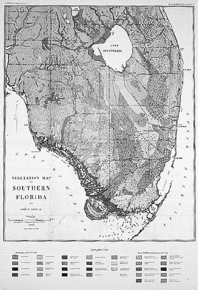
Natural Systems Map
showing vegetation
patterns that have
adapted to changing
conditions using the
available sustainable
energies (sunlight) and
natural resources (water,
soil) of the bioregion.
THE REGIONAL DESIGN PROCESS 31
change to this pattern is expensive and will need constant maintenance. The order,
form, and pattern is powered by sustainable free processes resident to the region.
The natural systems map illustrates the inherent value in understanding the tens
of thousands of years of trial and error that produced the hydrologic, soil, and veg-
etation systems, powered by sunlight, that exist today. Combining land-use plan-
ning with knowledge of the natural sciences inspires a sustainable fit.
The following are regionally sustainable elements that inform design:
䊏
Climatic conditions: Climate is a reoccurring pattern of generalities and aver-
ages that relate to temperature, humidity, precipitation, and air movement. A
climate is specific to conditions driven by solar and lunar cycles in concert
with water, soils, and geology. Within any climate, there are times when
human comfort can be achieved without mechanical intervention and times
when it cannot.
䊏
Precipitation: Rain, fog, sleet, and snow supply water to the air, to the
surface-water system, to soil saturation, and to groundwater storage. Water
was the critical factor in starting the tremendous biological explosion that has
led to today’s biodiversity. Plato said that water got the least amount of care
because it was so common. It is now generally agreed that water is the most
critical of all resources, is in a state of decline, and is the ultimate limit to all
growth and development.
䊏
Temperature: Most people refer to temperature when measuring the comfort
in a given setting. Their level of comfort or discomfort is often directly related
to the temperature in their environment. Although there are other factors,
including psychology, typically comfort is a function of temperature, humid-
ity, and air movement.
䊏
Humidity: The amount of water in the air is the culprit of many uncomfort-
able places. Because water is a big part of all biology and evaporating water
has a cooling effect, the more water in the air (high humidity), the less evap-
oration and cooling. Humidity also is a factor in creating uncomfortable con-
ditions in cold climates, because the water carries the cold temperature
through clothing and building skins, finding drier interior air and then cooling
it with evaporation, which is not desired in the winter.
䊏
Air movement: Wind, convection, and storms all create the movement of air
that changes the condition of the place. If a climate is hot and humid, the
small amount of dryness in the air can still remove perspiration if it moves
across the skin rapidly enough, creating cooling. This wind-cooling effect is
one of the reasons people live along the breezy coast in hot and humid
areas.
䊏
Topography: Vertical variations in the landscape are helpful in creating poten-
tial energy storages. Gravity is one of the most significant sustainable forces.
It can distribute water for free, and even stratification of microclimatic air
temperature is related to its presence. Topography plays an important role in
32 SUSTAINABLE DESIGN
establishing patterns for smart places to develop—out of flood plains, away
from coastal storm surges, and improved air circulation and movement.
䊏
Soils: When asked what would be the most critical piece of equipment he
would take to colonize a planet, the astronaut John Glenn answered, “Soil.”
Soil consists of chemical and electrical components that took billions of years
to develop. Full of biology, a cubic inch contains millions of nematodes.
Although food crops and plants can be grown in water alone (hydroponics),
it is soil and water that are sustainable and powered by natural cycles.
The natural systems map includes regional ecology, bioclimatic conditions,
growth patterns, and conflicts. The following represent challenges to be answered
by the regional-system researchers:
䊏
Learn how, when, and where the region’s bioclimate is compatible with
human development. Include comfort zones, location, sense of place, pro-
ductive soils, disaster mitigation, and precipitation.
䊏
Learn how the regional ecosystems function and how the climate is compat-
ible with human settlement, including food supply and region-specific job
creation.
䊏
Learn the natural landscape, the water-management strategy, ecosystem
management, and the creation, re-creation, or preservation of open space
and green and blue infrastructure.
䊏
Learn potential strategies for habitat creation and regionally appropriate con-
servation zones and development controls.
䊏
Learn and map compatibilities, conflicts, and relationships between eco-
nomic, social, and environmental systems.
䊏
Learn the regional energies and resources that can be exported and whether
there is a regional energy system.
䊏
Learn the regional building, zoning, and design codes that support sustain-
able design.
䊏
Learn the percentage of human-settlement energies (e.g., heating, cooling,
water, and food) that is supplied by the existing regional bioclimate and soils.
Include precipitation, naturally occurring surface-water flows that are due to
topography, and any regeneration of soils that is due to naturally occurring
nutrient cycling—determine the missed opportunities.
䊏
Learn if the region can function during drought or blackout.
䊏
Learn the carrying capacity—that is, how many people, plants, and animals
can be supported by the existing water crop and natural resources in the
region.
A map of the same scale as the natural systems map can be used to establish the
precipitation and water storage patterns. This precipitation over thousands of years,
combined with the soils and hydrologic periods, created the ecological systems of
THE REGIONAL DESIGN PROCESS 33
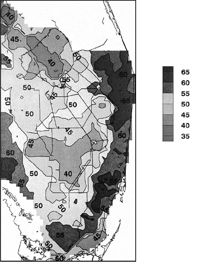
that landscape and biome. Changes to this balance will cause profound changes in
the system. It may take decades to see these impacts, but they will come, and they
will be very difficult and expensive to correct.
This precipitation study also has topographic information attached to it. All pre-
cipitation is spatial, meaning that over the region it lands in different amounts at
different locations and at different times. This map illustrates the location of the
The Water Supply Map:
Geohydrology. The legend
shows average inches of
rainfall. Precipitation is
a spatially allocated
supply with large
variations.
34 SUSTAINABLE DESIGN
largest amount of rainfall and compares it to development patterns. When devel-
opment occurs, pervious surfaces are replaced by impervious ones—the ground-
water recharge is, therefore, significantly reduced and flooding increases.
Elements to be included in this map are as follows:
䊏
Hydrological periods and seasonal quantities: highs, lows, and averages
䊏
Drought frequencies
䊏
Water quality
䊏
Flooding
䊏
Surface water and flood plains
䊏
Groundwater storages and recharge locations
URBAN SYSTEMS MAPS: COMMUNITY DESIGN AND GREEN
INFRASTRUCTURE CONNECTION
The following represents research and learning that will help promote the reconnec-
tion with green infrastructure within communities and neighborhoods:
䊏
Learn how urban patterns promote connection to local renewable resources,
to its sense of place, and to regional context.
䊏
Learn how community (or public) space, transportation strategy, and livable-
community standards are improved by connection to the regional ecological
model.
䊏
Learn how the orientation of streets and buildings helps improve comfort and
reduce discomfort in towns and within buildings.
䊏
Learn if building codes are compatible with healthy building design, material
reuse, deconstruction, and green industry standards.
䊏
Indicate the percentage of the building’s users who will travel to site by pub-
lic transit (either bus, subway, light rail, or train), carpool, bicycle, or on foot.
䊏
Connect pedestrian pathways with other public systems—for example,
greenways (microclimate cooling, habitat, neighborhood-edge definition) or
blueways (flood control, aquifer recharge)—so that there is connectivity, effi-
cient use of public funds, and an improved civic realm.
Establish the location of existing urban growth and development boundaries
over time. The following locations should be included on the urban systems maps:
䊏
Native peoples and pathways
䊏
Early settlements
䊏
Conservation and preservation areas
䊏
Neighborhoods and edges
䊏
Urban centers
THE REGIONAL DESIGN PROCESS 35
䊏
Parks and open spaces
䊏
Rail and stations
䊏
Highways and roads
䊏
Urban development boundaries
䊏
Built infrastructure
Economic system: The economy is supported and subsidized by the environ-
mental conditions. Businesses and urban patterns that incorporate sustainable
renewable energies have a competitive advantage over those that import energy.
䊏
Learn how and where the environmental connection enhances the long-term
economic benefit while creating social and environmental value. (See “Cache
Valley, Utah,” Regional Case Studies, page 43.)
THE REGIONAL DESIGN PROCESS ILLUSTRATED
Knowledge of the biome informs the (1) presettlement conditions, which inform the
(2) safe, commonsense-development locations, and this knowledge, applied over
the presettlement patterns, (3) establishes the conflicts and sets goals for (4) evolv-
ing to sustainable settlement patterns.
Combining biology and community creates a human ecology or a biological
urbanism, a biourbanism. Biourbanism incorporates the natural-system sciences of
the region into the urban and community pattern, connecting the urban, agricul-
tural, and natural-system functioning.
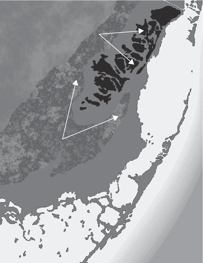
The Predevelopment Pattern Illustration (page 37), which depicts areas of well-
drained and poorly drained soils, is consolidated from the information on the Natural
Systems Map (1943 Davis vegetation map). The dark areas, representing the ele-
vated, well-drained soils of the coastal ridge, are more suitable for development and
will remain out of harm’s way and away from a rising sea level and storm surge. The
lighter areas—representing the lower, saturated soils of the Everglades, the trans-
verse glades, and the coastal marsh—tend to flood and are consequently not suit-
able for human settlements. Drainage of these low-lying areas reduces the regional
water storages and consequently reduces the whole system’s carrying capacity. Of
significant importance is the loss of this area’s historic ability to store water for future
use and to reduce impacts from drought.
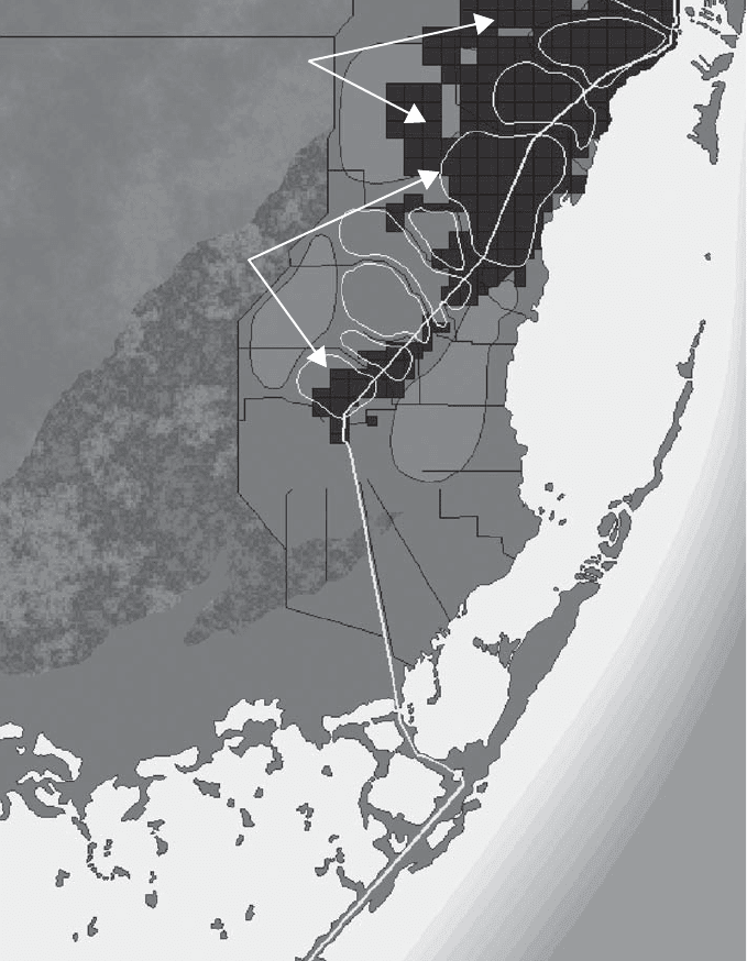
The Systems Conflict Map (page 38) overlays the 100-year flood plain on the
existing development grid. As can be seen, much of the recent development in
South Dade County, Florida, has occurred in areas that are flood- and storm-surge
prone and less suitable for long-term development. Because these areas are becom-
ing more impervious and more developed for urban uses, the flood criteria and
impacts are changing. Once the groundwater has been lowered, there will be a sig-
nificant reduction in regional storage. To combat this, new conservation areas must
be designated for regional recharge. This illustration suggests that these new areas
include historic Everglades wetlands, ecologically valuable coastal marshes, and crit-
36 SUSTAINABLE DESIGN
ical recharge areas for public waterwell fields. Continued development within these
areas, which is the present-day pattern, will cause more local flooding, eliminate crit-
ical aquifer recharge areas, destroy valuable natural resources, and negatively impact
marine health and the billion-dollar fishing industry.
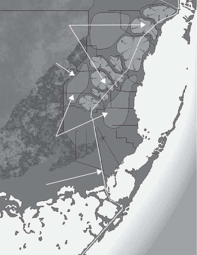
The Smart-Growth Areas Map (page 39) illustrates how the land and water
interact naturally in South Dade County. The lighter forms represent the areas
Predevelopment Pattern.
A 500-square-mile area
informed by gravity,
geology, solar power, and
water for millennia.
THE REGIONAL DESIGN PROCESS 37
Well-Drained Soils &
Higher Elevations/
Pine Uplands
Poorly Drained Soils &
Lower Elevations/
Wetlands & Coastal Marsh
located along the coastal ridge that are at elevations above the 100-year flood
plain. Storm water flows off these areas along the coastal ridge, to areas of lower
land elevation and estuaries. This water eventually flows to the drainage canals
and ultimately to Biscayne Bay. The areas, located on either side of the coastal
ridge, are the pervious and porous areas that provide critical water recharge to
the Biscayne Aquifer.
The evolving Systems-Design Approach (page 40) illustrates opportunities to
recapture, over time, the free work of nature, which will efficiently collect, store,
38 SUSTAINABLE DESIGN
Systems Conflict Map. As
the region developed,
community growth areas
became less related to
natural flood protection,
resulting in required
fossil fuel–powered
pumping.
Area Unsuitable for
Development
100 -Year Flood
Plain Line
clean up, and distribute water for all users, to urban, agricultural, and natural sys-
tems. It will also establish growth boundaries based on conservation zones, protect-
ing hydrological-recharge zones and productive agricultural lands and improving
urban and community patterns with transit-oriented development and walkable
communities.
The Sustainable Development Vision (page 41) shows the drainage canals
replaced by broad wetland systems similar to what was historically the transverse
glades. These topographic low points are an integral part of the region’s natural
Smart-Growth Areas
Map. The natural system
footprint remains.
THE REGIONAL DESIGN PROCESS 39
Area Above the 100 -Year
Flood Plain
Drainage Canals
Areas Best Suited to Provide
Aquifer Recharge
U.S.1
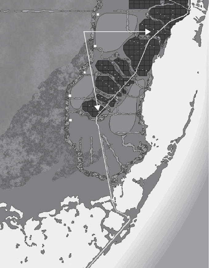
flood protection. The north-south canals, separating the developed part of Dade
County from the Everglades, are regenerated to provide valuable storage and water
cleansing.
This plan will improve the quality of water while preserving a sustainable water
supply for future users. The coastal canals become spreader canals to enhance the
distribution, timing, quantity, and quality of the water that flows to Biscayne Bay,
while protecting the biological food chain and supporting the sport-fishing industry
and ecotourism.
40 SUSTAINABLE DESIGN
Systems-Design
Approach. Establish
plans to recreate the
region’s natural systems
functioning and to
develop community-
based visions that are
based on a 100-year
evolution to a
sustainable development
model.
Existing Development
