Daniel E. Williams. Sustainable Design. Ecology, architecture and planning. (анг. яз)
Подождите немного. Документ загружается.

inition, or blueways, while also providing flood control, aquifer recharge, and
habitat—thereby creating connectivity? Are there connections to natural-
system connections? Are public funds used efficiently?
3. What percentage of consumed materials and resources are locally provided? In
particular, is the amount of water that lands on surfaces sufficient for commu-
nity needs? Are jobs and food available locally?
Sustainable Urban and Community Case Studies
The following case studies detail three urban, community-scaled projects. They have
in common scale, ecological analysis, and biourbanism. These case studies address
design and planning that reconnects to the natural resources within their respective
urban microclimates. The bioclimatic characteristics and analysis of natural systems
at the regional scale inform the planning and design process and enables the recon-
nection to sustainable resources on the urban and community scale. The three pro-
jects presented here are located in Belle Glade, Florida; Tucson, Arizona; and St. Paul,
Minnesota.
Lessons from Belle Glade: Can We Save the Everglades and Sustain Agricul-
ture?
Rio Nuevo Master Plan
Growing the Great River Park
LESSONS FROM BELLE GLADE: CAN WE SAVE THE EVERGLADES AND
SUSTAIN AGRICULTURE?
Glades Community Development Corporation
The negative impact of the agricultural industry on the Everglades National Park,
Florida, is well documented. The question is whether opposing natural and eco-
nomic systems can be redesigned to make them compatible. Can connections be
developed between agricultural and natural systems? Water in the Everglades
watershed is both abundant, due to considerable precipitation, and scarce, due to
lack of long-term storages. This design connected water-pollution abatement with
smart-growth patterns while restoring healthy, natural-system functions and civic
amenities.
Sustaining agriculture while protecting the quality and quantity of water distrib-
uted to the Everglades is illustrated in this charrette vision. Various ideas were
debated for months, creating a healthy atmosphere of the awareness that plans must
be built on consensus, knowledge, and the union of diverse community agendas.
The creation of regional open space has a value to communities as parks and
recreation while also acting as a regional recharge site for potable water. Conflicts
between urban and environmental needs are a constant issue. The Belle Glade plan
was developed by integrating environmental science with urban and regional design
SUSTAINABLE URBAN AND COMMUNITY CASE STUDIES 81
principles. The County Natural Resources Division used the plan to create a regional
network of hydric parks that eliminate flooding while storing and recharging the
potable water supply.
This regional design would be a win-win situation for the economy, the commu-
nity, and the environment. The natural system, in this case the Everglades National
Park, would receive cleaned-up sheet flow from the lake. The agricultural system,
degraded from the past 100 years of abuse, would be revitalized by using a gravity
irrigation-distribution system, reducing fossil-fuel dependence while rejuvenating
the historic town image.
The conceptual base for this project included the regional hydrological patterns
and historic flows of surface water in Everglades National Park. The application of
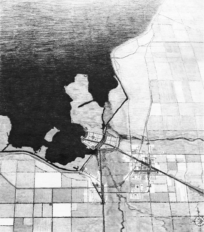
The town of Belle Glade,
Florida, is inextricably
connected to Lake
Okeechobee, the regional
lake system. There is a
complex relationship
between water, soil, and
the existence of 800
square miles of
agriculture and the
Everglades National
Park.
82 SUSTAINABLE DESIGN
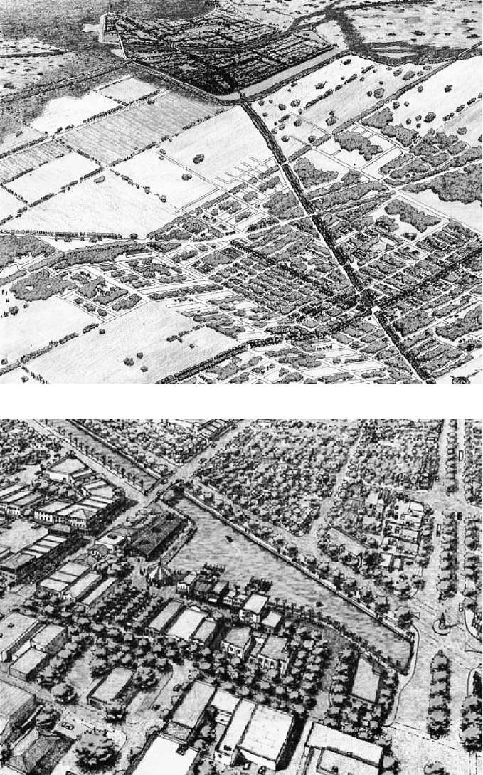
New Belle Glade visually
reconnects with Lake
Okeechobee, while the
lake’s hydrological
system rebuilds the soils
and creates an
opportunity for
ecotourism.
SUSTAINABLE URBAN AND COMMUNITY CASE STUDIES 83
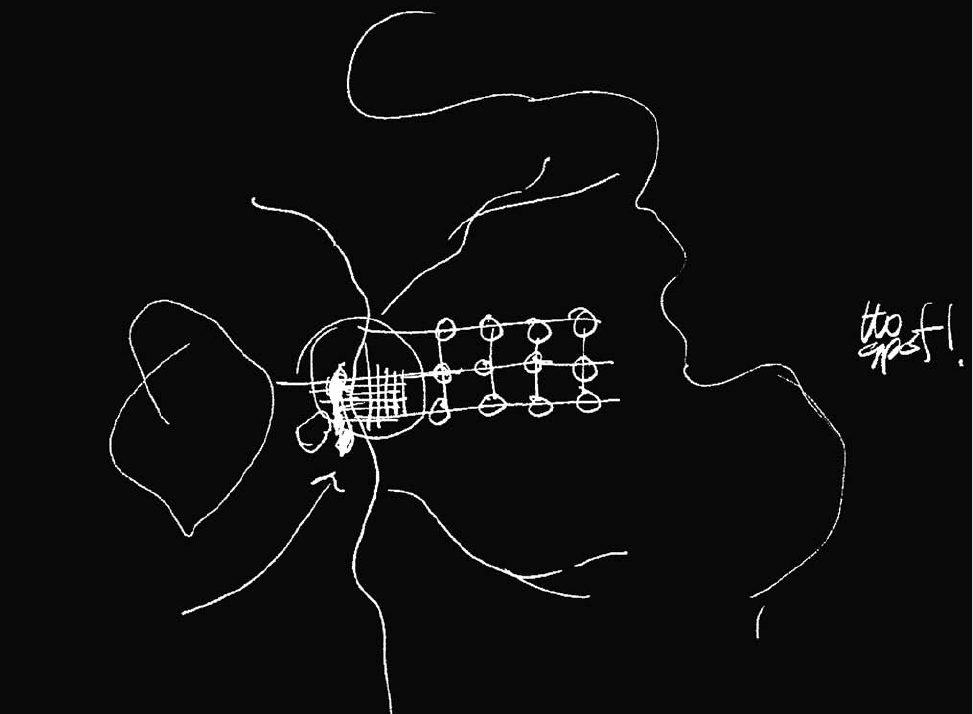
Connecting the new town
to the historic town with
urban canals and a
celebration of the
agricultural heritage.
this knowledge generated a plan that included protection of the natural system and
provision for a new agricultural economy based on seasonal hydration and rebuild-
ing of depleted soils.
The creation of the community’s well-being starts with the education and action
of its citizens. The Belle Glade charrette began with precharrette meetings—called
the Citizen Planner Series—intended to educate the community in basic planning
and design concepts (and what constitutes good planning and design), as well as
hydrological and ecological concepts necessary for sustainability.
The removal of the 120 lineal miles of levee that surround Lake Okeechobee
would create an industry for selling much-needed fill while reclaiming the valuable
lakefront and marsh edges that contribute to the health of the upland and aquatic
systems.
Design Team
The Glades Community Development Corporation—GCDC
The MacArthur Foundation
Center for Community and Neighborhood Design, University of Miami,
Miami, Florida
Team: Daniel Williams, Harrison Rue, Chris Jackson, Jamie Correra, Estella
Valle, and Eric Valle
RIO NUEVO MASTER PLAN
The following text was written by Mario Campos of Jones & Jones of Seattle.
Jones & Jones was the urban design consultant for Rio Nuevo, with Hunter Inter-
ests, Inc., as prime consultant for the City of Tucson.
Tucson, Arizona
Tucson evolved as a community of cultures intimately connected with the Sonoran
Desert and its mountains and rivers. Water was paramount to the development and
establishment of these cultures, and careful understanding of desert ecosystems
contributed to their successful use of water resources. As the city of Tucson has
grown, the pace of its development has threatened its historic identity and livabil-
ity. The original connections to these desert ecosystems have become tenuous, and
the community is now working to reestablish them, based on the city’s own multi-
cultural roots and natural heritage. The redevelopment will begin with the down-
town area and, at its core, the Rio Nuevo corridor along the Santa Cruz River and
the adjacent neighborhoods. The Rio Nuevo Master Plan is Tucson’s comprehensive
development plan. It is designed to turn the city around, give it a livable center, and
return it to a present-day livability. The master plan encompasses two plans that
coincide: a ten-year development plan and a long-range vision plan that incorpo-
rates projects that may be implemented within the ten-year life of a new Tax Incre-
ment Finance District (created in 1999), as well as projects that may extend well
into the future.
84 SUSTAINABLE DESIGN
Because the Rio Nuevo plan covers several important areas of the city and
beyond—for example, much of the downtown, a landfill at the site of significant
archaeological and historical elements (e.g., Native American pit houses and a Span-
ish mission and gardens), several old Hispanic and historic neighborhoods, the Santa
Cruz River corridor, and the adjacent Sentinel Peak park—master-planning develop-
ment required extreme sensitivity to cultural and environmental issues.
The Rio Nuevo plan provides a unique and flexible vision that is bold, innova-
tive, and unifying. The plan approaches the project from an economic, cultural, and
environmental sustainability perspective by healing and restoring the natural sys-
tems and cultural heritage of the disrupted areas and bringing them back from the
periphery to the heart of the city. It will be a celebration of nature and culture in the
streets, public squares, and open spaces of the city. Moreover, Rio Nuevo shows that
Long-established communities have a pattern based on the natural energies and resources that exist in the locale. Reconnecting
with that pattern starts with an analysis of the past integrated into the desires of the future.
SUSTAINABLE URBAN AND COMMUNITY CASE STUDIES 85
a plan centered on natural systems and the acceptance and inclusion of diverse cul-
tural values is one that can bring a divided citizenry together.
Designers recognized that the plan had to be innovative from an economic
development perspective as well, with a unique emphasis on market analysis, finan-
cial feasibility, and strategic leveraging of public investment to gain significant
commitments from both private and public investors. The Rio Nuevo plan thus rep-
resents a pragmatic blueprint for development based on market realities and current
development trends that are in harmony with environmental and cultural goals. It
can be implemented as a sustainable effort with achievable and measurable first
steps and actions that can be initiated immediately. More than a short-term blue-
print for development, the plan is a long-term healing strategy for a city that has
been torn apart.
86 SUSTAINABLE DESIGN
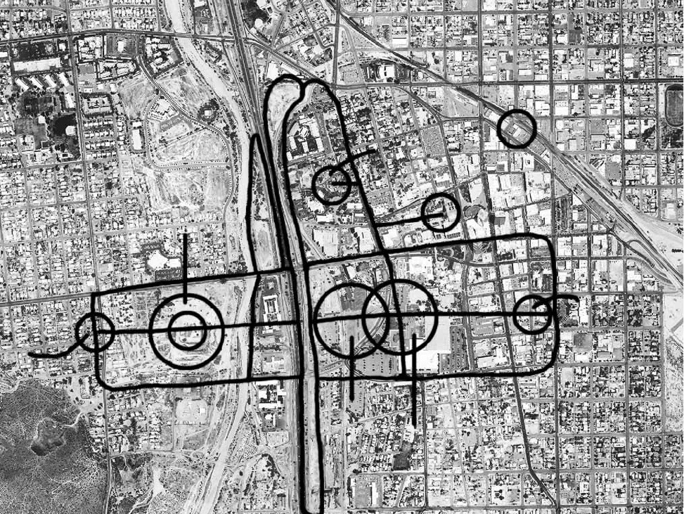
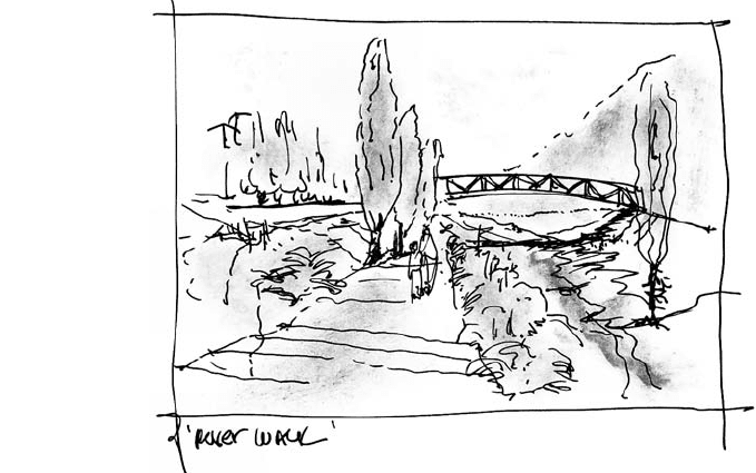
Conceptual reconnection of east and west communities that have been socially, economically, and environmentally fragmented
for years.
Disturbances to the original harmony of the city have come in several waves. A
freeway severed the city through the middle and disenfranchised neighborhoods
and residents, separating people and historic settlements from downtown and the
commercial center and separating the Santa Cruz River—now controlled and heav-
ily channeled—from the downtown and its plazas, the Presidio, and other historic
neighborhoods. Several blocks of traditional low-income but well-established His-
panic and minority neighborhoods were cleared for construction of a convention
center. Most of the material left over from the excavation was dumped on the other
side of the river, burying important archaeological sites.
Urban sprawl, strip malls, isolated condominium clusters, auto-dependent hous-
ing developments, and other ubiquitous models for development challenge the city
and continue to take over the surrounding Sonoran Desert. Memories of lost places
and displaced neighborhoods, the loss of usable active open space, the prevalence
of massive walls and inert facades, the ubiquity of empty streets in the evenings, and
the scale of projects such as the 1960s urban renewal convention center are daily
reminders to citizens that top-down planning and isolated megaprojects are unsuc-
cessful approaches to revitalization.
The Rio Nuevo Master Plan is the result of an extensive public-outreach pro-
gram that encompasses many environmental, historical, economic, and culturally
diverse points of view. It brings together successful grassroots preservation efforts
and arts investments and consequently builds a commitment to cultural diversity and
the renewal of public life, as it provides a new look at water and water resources and
creates a new paradigm for development and civic revival.
Rio Nuevo creates a network of interconnected places—such as a museum;
housing; mixed-use and commercial development; a unique system of parks, recre-
ational open spaces, cultural parks, plazas, and public urban places; entertainment
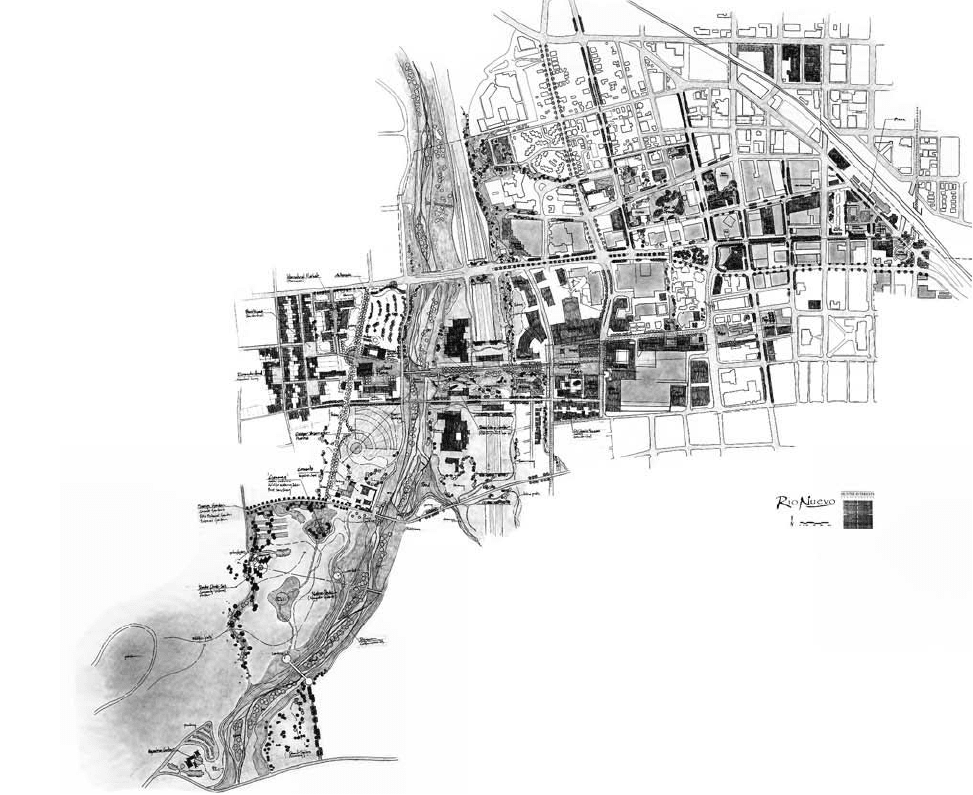
Recovering natural water
patterns that were part of
the region 100 years ago
requires stormwater
reclamation, storage, and
redistribution—to
regenerate a flowing river
that stopped 100 years
ago.
SUSTAINABLE URBAN AND COMMUNITY CASE STUDIES 87
areas; and sites for multiple business uses—all interwoven and in harmony with his-
tory, living natural systems, and cultural heritage throughout the Rio Nuevo District.
The plan builds on the early successes of local preservation efforts and a commit-
ment to diversity and the preservation of natural resources—water, in particular—in
an inclusive way, weaving ecology, history, architecture, and art into a vision for the
future. The core of the plan, as its name suggests, lies in the reclamation of the Santa
Cruz River as an environmental and cultural icon. The vision is of a restored riverbed,
with terraces and cottonwoods strewn along a corridor of public trails and pathways
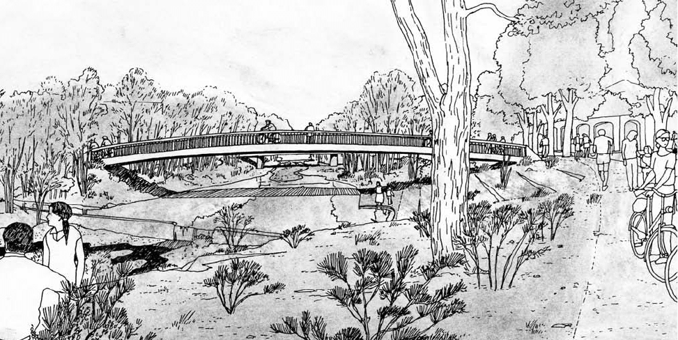
Tucson’s larger vision reclaims the stormwater and integrates it into the pattern of the city’s social, economic,
and environmental future.
88 SUSTAINABLE DESIGN
that provide public access to the river and amenities, as well as to cultural and recre-
ational opportunities.
The vision of new cultural and natural landscapes for the city comes together
on the floodplains and riverbanks of a restored riverbed, along with plants and ani-
mals and a better understanding of how generations of desert inhabitants and
dwellers sought life-giving water, cooling comfort, sustainable living endeavors,
and the company of others along the banks of the braided streams of river water.
The water—now a permanent, gentle flow that serves as intermittent storm-water
management—provides evidence of the river’s rich ecology and healing power and,
so too, the memory and imagination of the geography, history, and culture around
the river.
A restored Santa Cruz River would integrate the necessary technologies needed
for flood control and water management with a vision of the unique landscapes and
places that sustained life in the area for thousands of years. A series of workshops
with local residents and diverse constituencies, with barrio and long-time city resi-
dents, uncovered the memories and the vision. Long-time residents of Tucson told
stories of visiting the river on holidays and during important cultural ceremonies.
Although many argued over economic development, the need for flood control, res-
idential development models, and the location of cultural facilities, plazas, and
streets, they all agreed on the need to connect with the river and the natural world
in and around the city, with the extended goal of reuniting the healed river with the
The east and west connection is a celebration of past and future.
SUSTAINABLE URBAN AND COMMUNITY CASE STUDIES 89
city and the western barrios, reconnecting Sentinel Peak and the natural areas to the
downtown and commercial areas, traversing the highway intermittently, and creat-
ing a network of interconnected places and landscapes, of scenic corridors, and of
protected view sheds. The heart of the Rio Nuevo plan is a healing landscape and a
living flow of water that is intimately linked with the history of Tucson.
The Rio Nuevo Master Plan incorporates 19 or more cultural projects, 10 resi-
dential projects, 12 commercial and mixed-use projects, and several infrastructure
projects, resulting in a total capital investment need of approximately $750 million,
and the effective revitalization of the downtown area. The implemented master plan
will result in an average of $300 million-plus in direct impact annually, as well as cre-
ating more than 4,000 jobs.
The vision begins with restoring the river and reweaving the eastern and west-
ern neighborhoods together. Reconstructed islands, sandbars, and natural terraces
slow the water to a more even and natural pace, providing resting places for fish,
birds, and other wildlife. Carefully planned and designed weirs contribute to water
retention and habitat reclamation, accelerating the process of healing the river.
Banks and restored terraces support new plantings of indigenous cottonwoods, wil-
lows, Arizona ash, and other riparian trees and shrubs.
Sentinel Peak is a meaningful landmark also known as Shook-Shon Mountain,
which rises out of the banks of the river and its original settlements and evokes the
city of Tucson’s name. Rio Nuevo brings the mountain and river together; a
restored cienega (a desert marsh and watering hole) anchors a natural park habitat
for endangered amphibians and birds and provides interpretive and learning oppor-
tunities for visitors and residents. Situated in a mesquite shrubland with saguaros
and paloverde, an upland habitat that once served as an Indian burial ground, the
peak itself is restored as a functioning wilderness park connected to the river. A net-
work of trails provides access to the park for visitors and residents.
The natural park at the foot of Sentinel Peak connects the mountain to the river,
providing a continuum of habitat for wildlife and plants as well as an extended park.
Through careful reconstruction, the park design interprets important historical and
cultural elements. An elevated walkway along a recreated cienega illustrates the
value and role of important microhabitats in the desert and serves as a refuge for
birds and migratory fowl. Reconstructed acequias, or irrigation troughs, as first built
by the native Hohokam farmers for growing corn on the flood plain more than
1,000 years ago and then by Spanish settlers along the river, contribute to the
understanding of cultural landscapes and how careful use of water contributed to
sustainable life in the desert. Recreated foundations of the round dwellings of the
Pima Indians are interpreted for contemporary residents and visitors. Although noth-
ing remains of the late-eighteenth-century adobe Mission San Agustin del Con-
vento, the plan calls for a visitor center adjacent to the archaeological dig to interpret
the mission and its gardens, which are seen as the birthplace of Tucson.
A restored Santa Cruz River runs throughout the district, through strands of
restored arroyos, extending into the larger watershed to nourish a renewed environ-
90 SUSTAINABLE DESIGN
