Boggs S. Principles of Sedimentology and Stratigraphy
Подождите немного. Документ загружается.

13.3 Sequence Stratigraphy
457
level for streams that dra to the ocean. Changes in a stream's graded profile
can either create or remove accommodation space. Such changes can include
changes discharge, sediment supply, channel form, and uplift, as well as the po-
sition of the bayle (sea level). Application of sequence-stratigraphy concepts to
nonmarine systems is beg actively researched but is still controversial. The gen-
eral view is that the lower reaches (100-150 km) of fluvial systems are most likely
to be greatly affected by base-level changes and that it is this portion of fluvial sys-
tems that is most likely to be preserved in the stratigraphic record (see Shanley
and McCabe, 1994, and Vcent, Macdonald, and Gutteridge, 1998).
Global Sea-Level Analysis
General Principles. One of the most controversial applications of sequence
stratigraphy concepts is the analysis of ancient sea levels. As discussed through
out this book, changes sea level have an important bearing on sedimentation
pattes. Studies of sea-level changes have special relevance with respect to analy
sis of cyclic successions the stratigraphic record. Sea-level changes through time
have been studied particularly intensively by P. R. Vail and his associates at the
Exxon research laboratory in Houston (e.g., Va il, Mitchum, and Thompson, 1977a,
1977b; Haq, Hardenbol, and Vail, 1988). These authors used seismic data and sur
face outcrop data to tegrate occurances of coastal onlap, marine (deep-water)
onlap, baselap, and toplap to a model that involves asymmetric cycle oscilla
tions of relative sea level.
Vail and his group inferred changes in relative sea level by reference to
coastal onlap charts. These charts were constructed by estimating from seismic
profiles the magnitude of sea-level rise, as measured by coastal aggradation (the
thickness of coastal sediments deposited during sea-level rise). The amount of sea
level drop is determed by measuring the magnitude of downward shifts in
coastal onlap, that is, the elevation (vertical) difference between the point of max
imum coastal onlap reached at maximum sea level and the point of maximum sea
level fall, which is determined from the seismic records by the position where the
next (younger) onlap unit lies above the unconformable surface produced during
the sea-level fall (Vail, Mitchum, and Thompson, 1977a; Vail, Hardenbol, and
To dd, 1984). The procedures used constructg a relative coastal onlap chart
om coastal and mare sequences are illustrated Figure 13.18.
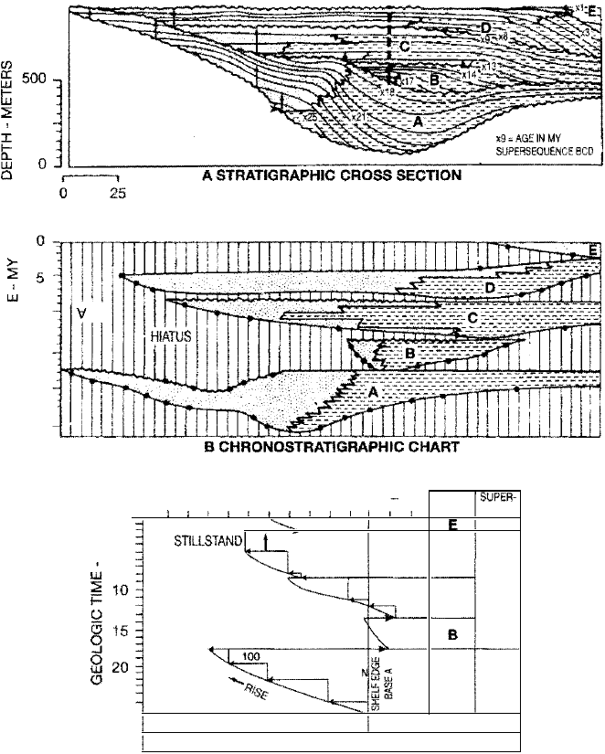
The first step volves analysis of sequences such as those shown as units A
through E of Figure 13.18A. Sequence boundaries, areal distributions, and the
presence or absence of coastal onlap and toplap are determined by tracing reflec
tions on seismic profiles. Available age controls from well data are used to estab
lish the geologic-time range of each sequence. An environmental analysis is also
made from seismic and other available data to distinguish coastal facies from ma
ne facies. The second step is to construct a chronostratigraphic (time-stratigraphic)
chart of the sequences, a procedure first described by Wheeler (1958). Both stratal
surfaces and unconformities give time-stratigraphic information. Because they are
depositional surfaces, the seismic response to strata surfaces are assumed to be
chronostratigraphic reflectors. In addition, because seismic reflectors are isochro
nous (have the same age everywhere), they can cross lithologic boundaries. That is,
the seismic reflections from a given surface may extend laterally through a variety
of lithofacies. Seismic reflectors may be traced continuously, for example, through a
shelf system, over the shelf edge, and downward through an equivalent slope sys
tem. Unconformities are not isochronous surfaces; however, strata below an un
conformity are older than strata above it. Therefore, strata between unconformities
constitute time-stratigraphic units. After determining the ages of depositional
sequences, such as those shown on the stratigraphic cross section in Figure
13.18A, from well-control or other information, workers plot the stratigraphic
458
Chapter 13 I Seismic, Sequence, and Magnetic Stratigraphy
gu 13.18
� 10
15
9
@ 20
25
D ASTAL DEPOSITS
MARINE DEPOSI
INnAL SHELF EE
t COASTAL AGGAOAT:ON
� SHIFT DOWNWARD
KM
METERS
Diagram illustrating the proce
dures used by Exxon geologists
for constructing a regional cycle
of relative coastal onlap. [After
Vail, P. R., R. M. Mitchum, Jr., and
S. Thompson, Ill, 1977, Seismic
stratigraphy and global change of
sea level, Part 3: Relative changes
of sea level from coastal onlap, in
Payton, C. E. (ed.), Seismic strati
gaphy-Applications to hydrocar
bon exploration: Am. Assoc.
Petroleum Geologists Mem. 26,
Fig. 13, p. 78, reprinted by per
mission of PG, Tulsa, Okla.]
0
5
25
:
:
-
:
=
c
-
500
400
300
200
100 0
100
CYCLES
I SUPER-
CYCLES
l I
I
I l
.
l
E
TOPlAP
STISTAND�
COASTAL
D
-RISE
�
BCD
�
c
450
50
FALL
B
�- COASTAL
8«
150 AGGRADATIO
'"1 -
I
100
ww
A
�i
i
HIGHSTAND
LOWSTAND
RELATIVE CHANGE OF SEA LEVEL
C REGIONAL CHART OF CYCLES
OF RELATIVE COASTAL ONLAP
FALL-
information against geologic time to construct a chronostratigraphic correlation
chart (Fig. 13.18B). Such charts are referred to as Wheeler diagrams. The final step
in
the procedure is to identify cycles of relative coastal onlap in each seismic se
quence, measure the magnitude of aggradation and seaward downshifts in coastal
onlap that result from relative se and fall of sea level, and plot these changes and
sea-level stdslls against geologic time as shown in Figure 13.18C. Thus, the
magnitude of coastal aggradation is a measure of a relative rise in sea level; a rela
ve standstill is indicated by coastal toplap; and seaward shifts in coastal onlap
indicate a relative sea-level fall. The plots of relative coastal onlap are repeated for
each sequence (cycles A though E of Fig. 13.18C) to complete the relative coastal
onlap chart. Finally, the changes in relative coastal onlap are used as the basis of
inferring changes in relative sea level. For simplicity, it is assumed that there has
been
no subsidence of the margin and that the bed-thinning eects of compaction
under deep burial have been considered (original thickness restored).
The time interval occupied by a relative se and fall of sea level, as ter
preted from a coastal onlap chart such as that shown in Figure 13.18C, constitutes
a
cycle of relave sea-level change in a region. Vail, Mitchum, and Thompson
Plioc.
-
Pieistoc.
Miocene
Oligocene
Palaeoc. & Eocene
Ctaceous
Jurassic
Triassic
Permian
Carboniferous
Devonian
Silurian
Ordovician
Cambrian
1 OO's of m above
present sea level
6 5 4
3 2
1
0
.
2
�
\
/
(
\
(
\
�
!
654321
0
A
�
'
'
'
Present
Sea
level
�
\
"
/
/� �
�
�
\
-
�
\
\
�
�
B
!
i
13.3 Sequence Stratigraphy
459
Figure 13.19
Eustatic sea-level curves for Phanerozoic
time. (A) Hallam, 1984; (B) Vail, Mitchum,
and Thompson, 1977b. [From Hallam, A.,
1984, Pre-Quaternary sea-level changes:
Ann. Rev. Earth and Planetary Sciences, v.
12, Fig. S, p. 220, reprinted by permission.]
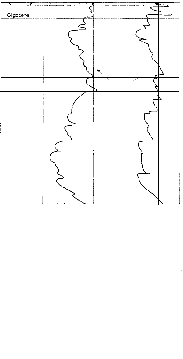
(1977b) correlated regional cycles and used this information to construct compos
ite charts of global cycles of relative sea-level change. ey interpreted these cy
cles to be worldwide and apparently to be controlled by absolute or eustatic
sea-level changes. Figure 13.19 shows the chart published by Vail, Mitchum, and
Thompson (1977b); a somewhat different chart constructed by Hallam (1984) from
mpilations of continental flooding is shown also for comparison. Upon publica
tion, the Exxon coastal onlap charts, and the relative sea-level curves inferred from
these charts, immediately generated lively interest, discussion, and controversy
among geologists. They continue to be a focus of controversy.
Reliability of Sea-level Analysis from sequence-Stratigraphic Data.
Following publi
cation of the coastal onlap curves of Vail, Mitchum, and Thompson (1977b), several
workers (e.g., Brown and Fisher, 1980; Kerr, 1984; Miall, 1986) challenged the basic
premise of the Vail group that these curves primarily reflect eustatic changes in
sea level, and they pointed out that tectonism (basin subsidence) and rates of sed
imt 5pply also affect these curves. Nonetheless, interest by the geologic com
munity in sea-level analysis continued at a high level. The publication in 1988 of
the SEPM Special Publication Sea-Level Changes: An Integrated Approach, edited by
Wilgus et a!., is an indication of this interest. This volume contains several articles
on analysis of sea-level changes as well as articles dealing with sea-level changes
460
Chapter 13 I Seismic, Sequence, and Magnetic Stratigraphy
Figu 13.20
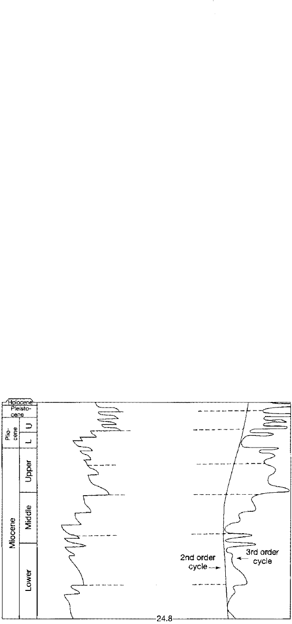
and sequence stratigraphy. In this volume, Hag, Hardenbol, and Vail (1988) pre
sent a new generation of coastal onlap curves and corresponding eustatic sea-level
curves for the Mesozoic and Cenozoic (originally published by the same authors
in 1987) that have been the subject of considerable subsequent discussion and con
troversy (e.g., Christie-Blick, Mountain, and Miller, 1990; Hallam, 1998; all,
1991, 1992, 1994, 1997; Walker, 1990). Haq, Hardenbol, and Vail (1988) indicate at
these new curves are based on well-log and outcrop data as well as seismic data
and have greater resolution than that obtainable from seismic data alone. These
highly
detailed curves are not reproduced in full here; however, a much simplified
portion of the late Te rtiary and Quateary curve is shown in Figure 13.20 to illus
trate the coastal onlap chart and show the nature of the second-order and thi
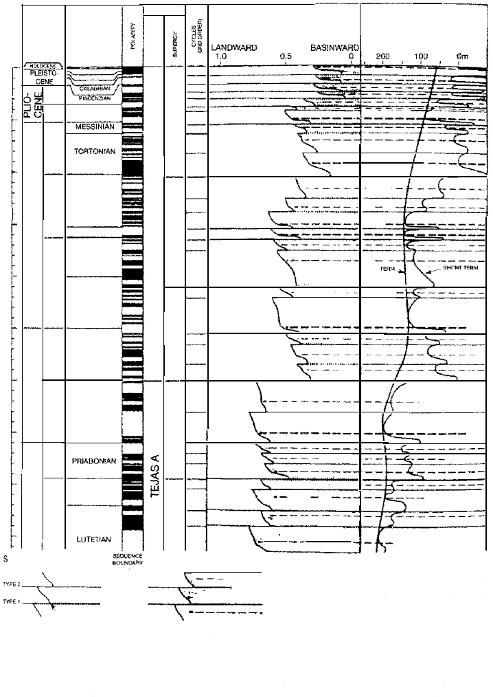
order sea-level cycles interpreted from this chart Figure 13.21 shows a more
complete, but still simplified, part of the cycle chart for the Te rtiary.
Christie-Blick, Mountain, and Miller (1990) provide a comprehensive cri
tique of seismic stratigraphy and its usefulness in sea-level analysis and interpre·
tation of the stratigraphic record. With respect to the Haq, Hardenbol, and V
(1988) curves, Christie-Blick et a!. are particularly conceed by what they call the
uncritical interpretation of all second- and third-order boundaries as resultg
from eustatic sea-level changes. They matain that amplitudes of eustatic fluctu
ations cannot be inferred from seismic stratigraphic data alone because coastal
aggradation (the vertical component of onlap) is primarily a result of basin subsi
dence, not sea-level rise. Furthermore, downward shifts onlap reflect only the
rate of sea-level fall relation to the rate of bas subsidence. They suggest that
the large component of basin subsidence cannot be easily or objectively removed
to derive the smaller eustatic signal. Christie-Blick et a!. point out further that an
other major limitation of the global onlap chart is the uncertainties about the li
bration of many boundaries to the geologic time scale. Another potential problem
in interpretation arises from the operation of autocyclic mechanisms (Chapter 12),
such as delta switching, that can generate small-scale cycles. Miall (1991, 1992,
1994) also concludes that the implied precision of the Mesozoic-Cenozoic global
Coastal onlap
3rd ord er sea-level
cycles
Age
Millions
of
years
------
0.
8
----
-----
3
.
0
�---
-------
7
.
0
----
Eustatic cue
- Rise Fall ����
Coastal onlap and long-term (second-order)
and short-term (third-order) sea-level curves
for the late Tertiary and Quaternary, as de
termined by Haq et al., 1988. [Redrawn
from Haq, B. U., J. Hardenbol, and P. R. Vail,
1988, Mesozoic and Cenozoic chronostratig
raphy and cycles of sea-level change, in Wil
gus, C. K., et al. (eds.), Sea-level changes:
----- 1
0
.
5
---
-------
15
.
0-
--
An integrated approach: Soc. Econ. Paleon
tologists and Mineralogists Spec. Pub. 42,
Fig. 14, p. 94, reproduced by permission of
SEPM, Tulsa, Okla.]
-----
2
1
.0
---
-
24.
8
13.3 Sequence Stratigraphy
461
5
10
15
20
25
30
35
40
45
50
.NDORO,R>
SlES SlAE$
��
CoNE
�
��
.
�
\
'r
I
�
ZANCLEAN
�
-
-I
w
w
�
z "
w
0
;
Q
;
�
w
w
z
w
0
w
0
�
z
�
M<>>IN>AN
�-�
SERVAlllAN
NGHAN ' �
BURGAU a
�
AQUITANIAN
�
�
�
CHAITIAN
�
RUPEUAN
=
=
"-�"li
BAONIAN
�
8
0 �
LUTtAN
�
Q
i
�
�
!(
r-
-
f--
·-·
-
1-··-
-
-
RETIVE COASTAL ONP
EUSTATIC CURVES
�ow- �
'90
?m
------· ----·
7
�·
·
-
-
-t
-=
�·
\
·-
- -----
� ___
------�
-
-
·-
-
""
-
'
\------
_
_____
\
I
-�
I
----{
�----
-
-
-
-
-
-
CONG
'�
-
-
-
______
·---
·
-
-
-
.
-
.. --=
�-�---
�
-
-
--
f
·--
--
.
.:.c
c-
-
-
1--" ,_,
-
---
.......
�- ..
-
-�
-
·
---
1---
r
--
----
\
-
-
-
- --
...
-
-
-
-
-
-
-·
\---------
-
-
-
-
-
-
-
-
- --
1
-
-
-
-----
-
-
--- --
1-·-
1- .---
-
----
·-----
1--
-
--
-
·
-
"
-
-
--
-
-
- --
1--
·-
·
-
-
-
·-1--
�-
-
-
--
-
-
--------
1-
- --------
\
'
-
1-f
-
-
-
-
-----
"
w
·
'
"
�
EQUEN�E BOUNDARY TYPES
a
K TO RELATIVE MNITUDE
�=�
' LOWStAND FAN
OCPOSS WITHOUT
COASTAL ONP
Mmor
Mium
Major
�----
-
,
--
-
�
-
-
-
-
-------
Minor
Mium
Maj
• S£££ IN
REY10US CYC CHARTS
CENOZOIC·. B. U. HAO, J. HAENBOL, R R. VAIL
R. C. WRIGHT, L E. STOVER, G. BAUM. T. LOUTIT.
A. GOMBOS. T DAV' ES, C. PR.UM, K. ROMINE.
H. POSAMENTIER, R. JAN DuCHENE
cycle chart of Haq, Hardenbol, and Vail (1988) is not justified. He maintains that
e chart is not an independently tried and tested global standard and that the im
plied precision is unsupportable because it is greater than that of the best available
chronostratigraphic techniques, such as those used to construct the global stan
dard time scale (Chapter 15).
In spite of these criticisms, interest in sea-level analysis and sequence stratig
raphy in general remains high. To quote Plint et aL (1992), "The Exxon sea-level
curve is here to stay, although it is likely to undergo progressive evolution and re
nement as more data are gathered and better chronostratigraphic control be
comes available." Over the next several years, geologists all over the world will
surely be watching the outcome of the sea-level controversy. Hallam (1998) points
out that relative sea levels can be studied by using an alteate approach that em
ploys facies analysis. Fundamentally, this approach involves estimating relative
sea-level changes by studying shallowing-upward successions carbonate and
siliciclastic rocks.
Figure 13.21
Simplified global sequence
chart for part of the Te r
tiary and Quaternary. The
polarity column shows the
geomagnetic time scale
(explained in Section
13.4); series and stages are
discussed in Chapter 15.
[After Haq, B. U., ). Hard
enbol, and P. R. Vail, 1987,
Chronology of fluctuating
sea levels since the Triassic:
Science, v. 235, Fig. 2,
p. 1158. Copyright 1987
by the AMS. As redrawn
by Vail et al., 1991.]

462
Chapter 13 I Seismic, Sequence, and Magnetic Stratigraphy
Summa Remar. The sequence concept produced a revolution in stratigraphy
during the 1980s and early 1990s and gave rise to the term sequence stratigraphy,
defined as the study of rock relationships within a chronostratigraphic (time
stratigraphic} framework of repetive, genetically related strata bounded by sur
faces of erosion or nondeposition or their correlative conformities (Van Wa goner
et al., 1988). Numerous geologists have embraced the sequence stratigraphy con
cept, and it is currently widely applied, particularly within the peoleum industry,
to a variety of stratigraphic successions. Since the initial concept was proposed,
numerous papers on sequence stratigraphy have been presented at scientific
meetings and published in the geological literature. The concept has not, however,
been without its detractors, as menoned. It has been cricized, among other
things, for being largely theoretical and introduced without specific, worked-out
examples; for inadequate attention to problems of scale; and for an overemphasis
on eustatic sea-level cycles without due regard to the effects of local tectosm and
sediment supply. Also, it is diicult to apply the sequence concept to nonmarine
and deep-sea sediments, which may not be subdivided into well-defined uncon
formity-bounded units.
Nonetheless, the sequence-stratigraphic concept is now widely embraced
and has certainly revived interest in stragraphy and produced many new ideas.
The aspect of sequence stratigraphy that deals with global eustasy has been the
most severely criticized part of the theory. As discussed, many geologists simply
do not believe that reliable global sea-level charts can be constructed from
quence-stratigraphic data. On the other hand, most geologists agree that relative
sea-level changes do affect the geometry and facies distribuon of sediments de
posited on continental margins and within sedimentary basins. Such facies can
effectively studied and interpreted by using outcrop and subsurface data within a
sequence-stratigraphic framework. Thus, sequence stratigraphy appears to be a
useful tool for stratigraphic analysis even if the global nature of sea-level curves
produced by the Exxon group cannot be proven.
Galloway (1989) proposed an alternative method for defining sequences
based on the concept of repetitive episodes of progradation punctuated by peri
ods of transgression and ooding of depositional surfaces. Galloway's sequences
are bounded by features formed during maximum submergence, in contrast to the
Exxon sequences, which are bounded by features formed during maximum emer
gence. At this time, the Exxon scheme for defining sequences appears to be more
widely understood and used.
13.4 MAGNETOSTRATIGRAPHY
General Principles
Magnetic stratigraphy, or magnetostratigraphy, is a relatively new branch of
stratigraphy developed largely since about the middle 1960s. The principles of
magnetic stratigraphy were initially applied to the study of volcanic rocks and
sediments younger than about 5 million years. Magnetic stratigraphic techniques
have now been applied to much older rocks, and a detailed magnetic polarity time
scale has been extended to the Jurassic and parts of the older record. Magnetic
stratigraphy came about through the discovery that magnetic iron-rich minerals
in igneous and sedimentary rocks can preserve the orientation or field direction of
Earth's magnetic field at the time the rocks were formed. During the cooling of
molten rock, iron-bearing minerals become magnetized in alignment with Earth's
magnetic field as they cool through a critical temperature of about 500°C-600°C
(for magnetite), the Curie point. As they approach this temperature, the influence
of the magnetic field exerts itself, and the atomic-scale magnetic fields within the

13.4 Magnetostratigraphy
463
crystal lattices of the minerals begin to line up parallel to one another and to the
direction of e magnetic lines of force around Earth. With further cooling, these
atoms become locked into this orientation, and each mineral in essence becomes a
small magnet, having polarity consistent wi Earth's magnetic field. These mag-
netic properties are retained for geologically long periods of time unless the rocks
are again heated to near the Curie point. Therefore, this residual magnetism
called remanent magnetism, or thermal remanent magnetism (TRM).
During deposition of sediments, small magnetic mineral grains are able to
rotate in the loose, unconsolidated sediment on the depositional surface and thus
align themselves mechanically with Earth's magnetic field. This (statistically) pre
ferred orientation of magnetic minerals in sedimentary rocks imparts bulk mag
netic properties to the rocks, referred to as depositional remanent magnetism or
deital remanent magnetism. Because sediment grains can be disturbed by bio
turbating organisms or by physical and chemical processes during burial and dia
genesis, the magnetization of sedimentary rocks is less stable, as well as weaker,
than that of volcanic lavas. The study of remanent magnetism in rocks of various
ages to determine the intensity and direction of Earth's magnetic field in the geo
logic past is called paleomagnetism.
Remanent magnetism is measured by instruments called magnetometers.
Early magnetometers were capable of making paleomagnetic measurements only
in ieous rocks and hily magnetized iron-bearing red sediments. Modem su
perconducting magnetometers can measure the magnetism much more weakly
magnetic sediments, including carbonates. Remanent magnetism is complex and
can include secondary magnetism caused by prolonged eects of Earth's present
magnetic field or by chemical changes owing to alteration of one magnetic miner
al to another. Demagnetization techniques are available for destroying this sec
ondary magnetic effect in the laboratory so that the primary magnetization can be
measured. It is this primary magnetic component, which records Earth's geomag
netic field at the time volcanic or sedimentary rocks formed, that is of interest in
satigraphic studies.
The significance of primary remanent magnetism for stratigraphic studies
stems from the fact that Earth's maetic field has not remained constant through
out geologic history but has frequently reversed. The geomagnetic eld is gerat
ed in some poorly understood way by the motion of highly conducting nickel-iron
fluids in the outer part of Earth's core; this motion is assumed to be controlled by
thermal convection and by the Coriolis force generated by Earth's rotation, consti
tuting what is called a self-exciting dynamo (e.g., Butler, 1992; Merrill, McElhin
ny, and McFadden, 1996). Studies of the remanent magnetism in igneous and
sedimentary rocks show that the dipole (main) component of Earth's magnetic
field has reversed its polarity at irregular intervals from Precambrian time on
ward, apparently because of instabilities in outer-core convection (Merrill, McEl
hinny, and McFadden, 1996). ' hen Earth's magnetic field has the present
orientation, it is said to have normal polarity. When this orientation changes 180°,
it has reversed polaty.
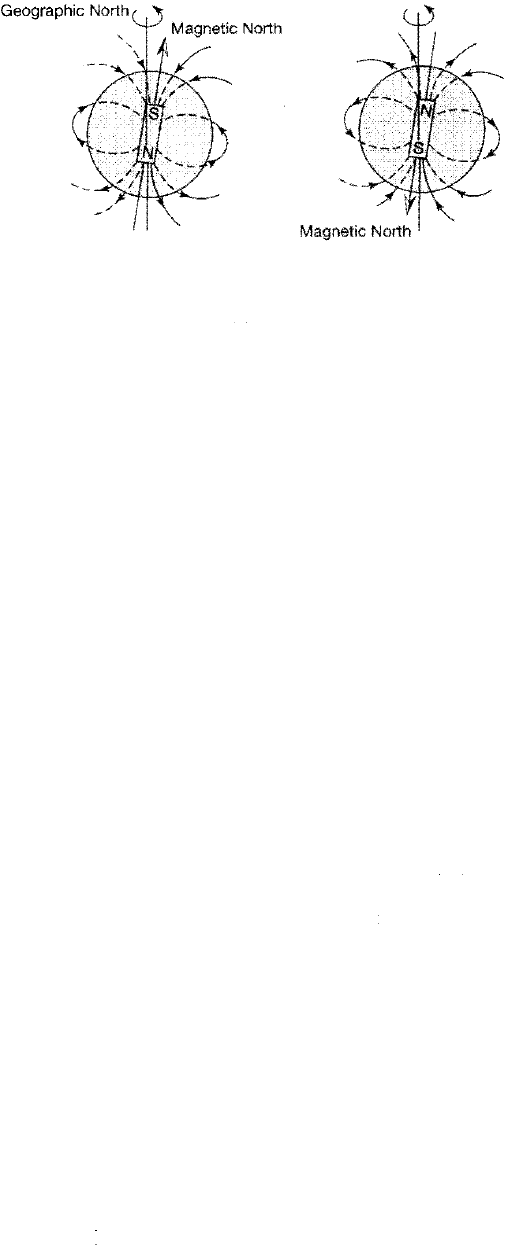
Figure 13.22 illustrates diagrammatically the magnetic lines of force around
Earth during normal and reversed polarity epochs. Note that during a time of nor
mal polarity the magnetic lines of force appear to "flow" out of Earth at the geo
graphic South Pole, bend around Earth, and reenter at the geographic North Pole.
Thus,
a compass needle hinged vertically (swings up and down) would point
down (into Ear) at the North Pole and up (out of Earth) at the South Pole. The
flow direction of the magnetic lines of force, and the direction of a compass nee
dle, would reverse during an episode of reversed polarity.
Reversals of Earth's maetic field are recorded in sediments and igneous
rocks by patterns of normal and reversed remanent magnetism. e direction of
magnetization of a rock is defined by its north-seeking magnetization. If the
464
Chapter 13 I Seismic, Sequence, and Magnetic Stratigraphy
(A) NORMAL
(B) REVERSE
Geographic Noh
Figure 13.22
Schematic representation of Earth's magnetic
field during episodes of (A) normal and (B) re
versed polarity. [After Wylie, P. )., 1976, The
way the Earth works: john Wiley and Sons,
Inc., Fig. 9.1, p. 120, reprinted by permission.]
north-seeking magnetization of rocks points toward Earth's present magnetic
north pole, the rock is said to have normal-polarity magnetization. If the north
seeking magnetization points toward the present-day south maetic pole, the
rock has reversed-polarity magnetization, or reversed polarity. Thus, sedimenta
ry and igneous rocks that display bulk remanent magnetic properties of the same
magnetic polarity as the present maetic field of Earth have normal polarity,
whereas those that have the opposite magnetic orientation have reverse polarity.
These geomagnetic reversals are contemporaneous worldwide phenomena.
Thus, they provide unique stratigraphic markers in igneous and sedimentary
rocks. The reversal process is thought to take place over a period of 1000-10,000
years (e.g., Clement, Kent, and Opdyke, 1982). The intensity of the maetic field
decreases by 60-80 percent over a period of about 10,000 years preceding reversal.
The actual reversal requires about 1000-2000 years, followed by a buildup of
tensity for the next 10,000 years (Cox, 1969). The last unquestioned reversal of the
magnetic field took place approximately 700,000 years ago, although a brief rever
sal
or excursion of the field may have occurred about 20,000 years ago.
[Note: The intensity of Earth's magnetic field has been declining over the past
few centuries. It has decreased by 10 percent the past 300 years, and the rate of
decline is increasing. It is possible that the magnetic field will fall to nearly zero in
the next millennium, leading scitists to speculate that another magnetic reversal
is in the making (Nova, 2003). Think what that would do to compass dictions!]
In
the early years of paleomaetic study, intervals of reversed or normal po
larity lasting 100,000 years or more were called epochs and those having a dura
tion of about 10,000-100,000 years were called events. Geomagnetic polarity
reversals
are now known to occur on a much broader spectrum of time scales
ranging from less than 10,000 to gater than 10 million years. Maetic stratigra
phy is based on these changes in polari recorded in sediments or volcanic rocks
that produce recognizable patterns of alternating-polarity stratigraphic units that
can be used for chronological and correlation purposes.
Sampling, Measuring, and Displaying Remanent Magnetism
To determine remanent magnetism sedimentary rocks, geologists commonly re
move samples from the field for subsequent laboratory analysis (see McElhinny
and
McFadden, 2000, and Ta uxe, 2002, for details), although techniques have been
developed to measure remanent magnetism in well bores (e.g., Bouisset and Au
gustin, 1993). Three kinds of samples may be taken:
1. Samples cored with a portable drill. Cores taken by this method are com
monly 2.5 em in diameter and 6-12 em long. Before cores are broken out of the
rock on the outcrop, the orientation of the cores must be determined and
13.4 Magnetostratigraphy
465
marked on the sample. The inclination (dip) of the core axis is determined and
the azimuth of the core axis (deviaon om geographic north) is measud by
use of a magnetic and/ or sun compass.
2. Oriented block (hand) samples. These samples, which are broken om the
outcrop with a hammer, are easier to obtain an core samples but present
more difficulties with later orientation in the laboratory instruments.
3. Cores of lake- or ocean-bottom samples. Sediment cores, commonly obtained
by piston coring apparatus, are assumed to penetrate the sediment vertically
but are azimuthly unoriented.
In e laboratory, the remanent magnesm of a rock specimen is measured by
means of a magnetometer. Several types of magnetometers (balanced fluxgate, cy
genic, astac, spier) are used (Hailwood, 1989; Butler, 1992). Three orthogo
nal
components of magnetism are commonly measured; these three components
are then combined to give the diction and intensity of the magnetic vector of the
specimen. Because most rocks carry different components of magnetization that
have been acquired at different times, the signature of secondary maetism must
rem oved to reveal the primary remanent magnetism. Secondary magnetization
may be removed by progressive demagnetization methods such as alteating
field demagnezation, thermal demagnetization, and chemical demagnetization.
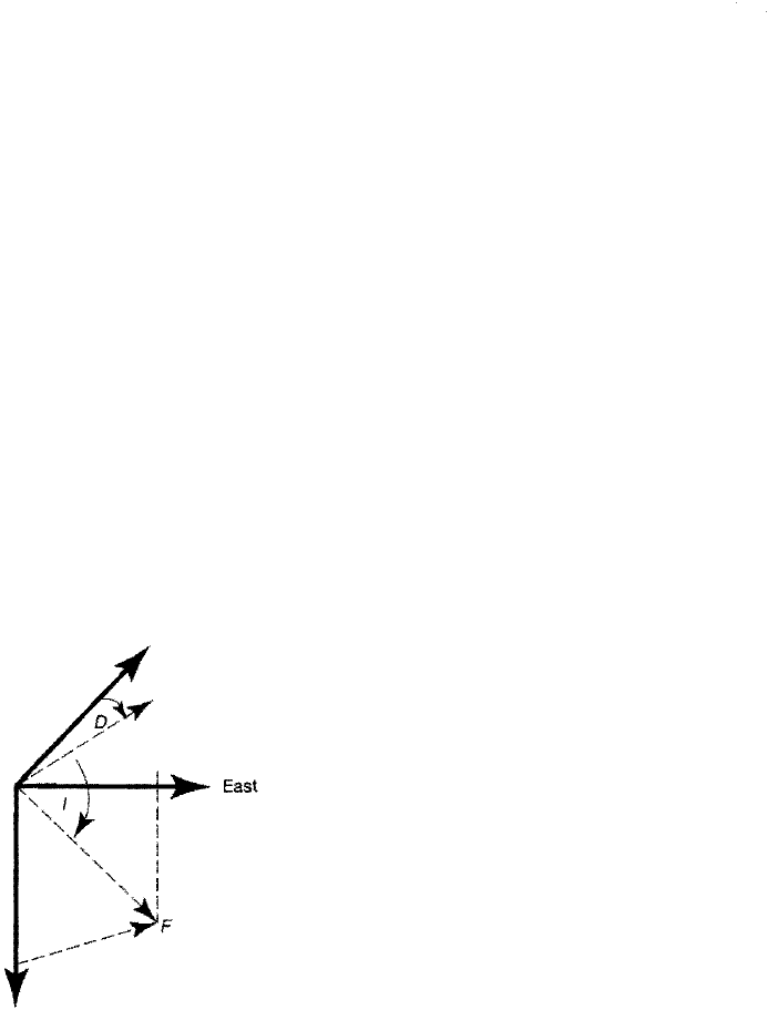
Once primary remanent magnetism has been measured, vector dictions in
paleomagnetism are described in terms of the following:
1. Inclination (with respect to component in the original bed at the collecting
station)
2. Declination (with respect to geographic north) (Fig. 13.23)
Inclination is called positive if downward directed and negative if upward direct
. Positive inclination in the Northern Hemisphere indicates normal polarity;
negative inclination means reversed polarity. Inclination directions are opposite
lative to the polarity in the Southern Hemisphere. Inclination and declinaon to
gether define the geomagnetic field vector (F in Fig. 13.23). Inclination is a func
on of the latitude at which the rock specimens formed, and declination shows the
deviation of the ancient paleomaetic pole from the geographic pole. The polaty
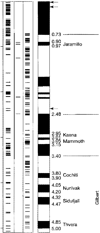
data are commonly displayed graphically in polarity-reversal satigraphic
columns by plotng intervals of normal polarity in black and intervals of reversed
Geographic noh
Vertical
component
Magnetic north
: (horizontal component)
I
I
re 13.23
Description of the direction of the geomagnetic field. The total magnetic
field vector F can be divided into a vertical component and a horizontal
component. The angle 0 is the declination, the azimuthal angle between
magnetic north and geographic north. The angle I is the inclination (dip),
the angle between the horizontal and F.
466
Chapter 13 I Seismic, Sequence, and Magnetic Stratigraphy
gu 13.24
Late Cenozoic (Pliocene-Pleistocene) geomagnetic polarity time
scale. Each horizontal line in the columns labeled normal polarity,
intermediate polarity, or reversed polarity represents an igneous
rock for which both K-Ar age and geomagnetic polarity have been
determined. Auxiliary information from marine magnetic anomaly
profiles and deep-sea core paleomagnetism have also been used.
Black pattern in the dominant-polarity column indicates normal
polarity; white indicates reversed polarity. Arrows indicate disputed
short polarity intervals or geomagnetic "excursions"; numbers to
the right of the polarity column indicate interpreted ages of polari
ty boundaries. [After Maniken, E. A., and G. B. Dalrymple, 1979,
Revised geomagnetic polarity time scale for the interval 0-5 m.y. B.
P. : jour. Geophysical Research, v. 84, Fig. 3, p. 624.]
K-Ar
Age
(Ma)
0.0
1.0
2.0
3.0
4.0
5.0
�
u
·�
-E
0
0
i
i
E
E
2
0
z
i
-
I
•
-
-
•
-
•
!
�
�
u
c
�
·�
0
0
.
c
Age
Polarity
Pola
�
c
.
E
(Ma)
event
epoch
>
0
0
Laschamp ?
Blake ?
l
c
2
=
-
E
1.67
Olduvai
�
1.87
Reunion
�x· ?
polarity in white (e.g., Fig. 13,24). Dating of the polarity intervals by radiometric and
biochronologic methods forms the basis of the maetic polarity me scale, de
scribed in the next paragraphs. Data may be plotted also as virtual geomaetic pole
(VGP) latitudes. e VGP represents the position of the eective north geomagnetic
pole calculated fm both inclination and declination information (Hailwood, 1989).
Magnetic Polarity Time Scales
The concept of remanent maetism is well known to today's students of geology;
however, only a few studies of rock magnetism had been made prior to the 1960s.
The basic principles of magnetostratigraphy were developed in the early and
middle 1960s in the remarkably short time of about five years by two groups of
