Awange J.,Grafarend E., Palancz B., Zaletnyik P. Algebraic Geodesy and Geoinformatics
Подождите немного. Документ загружается.

16-2 Algebraic diagnosis of outliers 293
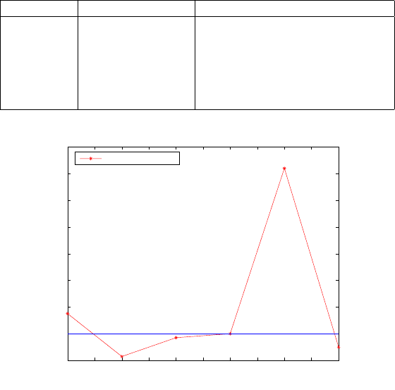
Table 16.1. Combinatorial positional norms and their deviations from that of the ad-
justed value (outlier free observations)
Combination Positional norm (m) Deviation from adjusted value (m)
1-2 48941.776 0.007
1-3 48941.760 -0.009
1-4 48941.767 -0.002
2-3 48941.769 0.000
2-4 48941.831 0.062
3-4 48941.764 -0.005
1 1.5 2 2.5 3 3.5 4 4.5 5 5.5 6
−0.01
0
0.01
0.02
0.03
0.04
0.05
0.06
0.07
Deviation of positional norm without outlier
Combinatorial No.
Deviation (m)
Outlier diagnosis
Figure 16.2. Deviations of the combinatorial positional norms from that of the adjusted
value (outlier free observation)
Example 16.3 (Outlier of 0.950 m in observation to station 2). Let us now consider
a case where the distance observation to station 2 in Table 12.11 has an outlier
of 0.950 m. For this case, the distance is falsified such that the observed value
is recorded as 1530.432 m instead of the correct value appearing in Table 12.11.
The computed deviations of the combinatorial positional norms from the adjusted
value (48941.456 m) and the median value of (48941.549 m) are presented in Table
16.2 and plotted in Fig. 16.3.
Given that there exists an outlier in the distance observation to station 2,
which appears in combinations (1-2), (2-3) and (2-5), i.e., the first, fourth, and
fifth combinations respectively, one expects the deviations in positional norms in
these combinations to be larger than those combinations without station 2. Values
of Table 16.2 columns three and four indicate that whereas combinations (1-3),
(1-4) and (3-4), i.e., the second, third, and sixth combinations respectively have
deviations in the same range (c.a. 0.3 m and 0.2 m in columns three and four
respectively), the other combinations with outliers are clearly seen to have varying
294 16 Algebraic diagnosis of outliers
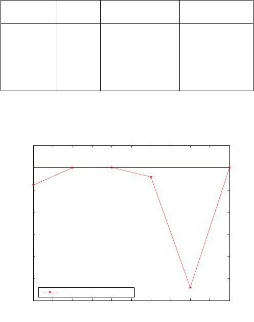
deviations. Figure 16.3 clearly indicates the first, fourth, and fifth combinations
respectively with outlying observation to have larger deviations as compared to
the rest. This is attributed to observation to station 2 containing gross error.
Table 16.2. Combinatorial positional norms and their deviations from that of the ad-
justed value and median (error of 0.950 m in observation to station 2)
Combination Positional Deviation from Deviation from
norm-(m) adjusted value (m) median value (m)
1-2 48940.964 -0.492 -0.585
1-3 48941.760 0.304 0.211
1-4 48941.767 0.311 0.218
2-3 48941.338 -0.118 -0.211
2-4 48936.350 -5.106 -5.199
3-4 48941.764 0.308 0.215
1 1.5 2 2.5 3 3.5 4 4.5 5 5.5 6
−6
−5
−4
−3
−2
−1
0
1
Deviation of positional norm with outlier of 0.950m in the 2nd observation
Combinatorial No.
(Deviation −0.3) m
positional norm deviation
Figure 16.3. Deviations of the combinatorial positional norms from that of the adjusted
value (error of 0.950 m in observation to station 2)
Example 16.4 (Outlier of 3 m in observation to station 4). Next, we consider a case
where observation to station 4 in Table 12.11 has an outlier of 3 m, which erro-
neously resulted from miss-booking of the number 6 as 9. This falsified the distance
such that the recorded value was 1209.524 m. The computed deviations of the com-
binatorial positional norms from the norm of the adjusted value (48942.620 m) and
the median value (48941.772 m) are given as in Table 16.3 and plotted in Fig. 16.4.
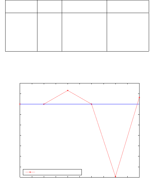
Given that there exists an outlier in the distance observation to station 4, which
16-2 Algebraic diagnosis of outliers 295
appears in combinations (1-4), (2-4) and (3-4) i.e., the third, fifth, and sixth combi-
nations, Table 16.3 columns three and four together with Fig. 16.4 clearly indicates
the deviations from these combinations to be larger than those of the combinations
without observation 4, thus attributing it to observation to station 4 containing
gross error.
Table 16.3. Combinatorial positional norms and deviations from the norms of adjusted
value and median (error of 3m in observation to station 4)
Combination Positional Deviation from Deviation from
norm-(m) adjusted value (m) median value (m)
1-2 48941.776 -0.844 0.004
1-3 48941.760 -0.860 -0.012
1-4 48944.388 1.768 2.616
2-3 48941.769 -0.851 -0.003
2-4 48927.912 -14.708 -13.860
3-4 48943.061 0.441 1.289
1 1.5 2 2.5 3 3.5 4 4.5 5 5.5 6
−14
−12
−10
−8
−6
−4
−2
0
2
4
Deviation of positional norm with outlier of 3m in the 4th observation
Combinatorial No.
Deviation (m)
positional norm deviation
Figure 16.4. Deviations of the combinatorial positional norms from that of the median
value (error of 3m in observation to station 4)
296 16 Algebraic diagnosis of outliers
16-22 Diagnosis of multipath error in GNSS positioning
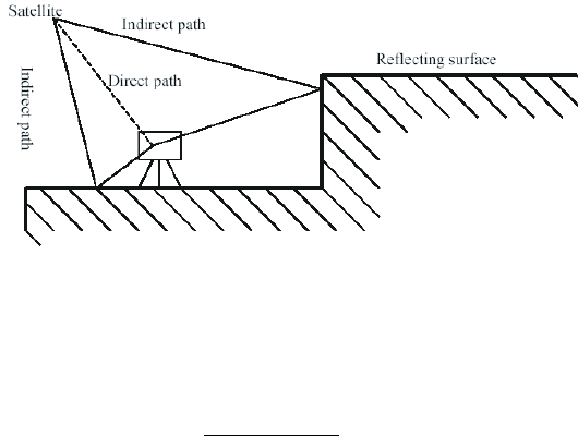
For GPS pseudo-ranging, consider that a satellite signal meant to travel straight
to the receiver was reflected by a surface as s hown in Fig. 16.5. The measured
pseudo-range reaching the receiver ends up being longer than the actual pseudo-
range, had the signal travelled directly. In-order to demonstrate how the algorithm
Figure 16.5. Multipath effect
can be used to detect outlier of type multipath, let us make us of Example 12.2
on p. 181. Using the six satellites, 15 combinations are formed whose positional
norms are computed using
P
i
=
q
X
2
i
+ Y
2
i
+ Z
2
i
|
i=1, . . . ,15
, (16.2)
where (X
i
, Y
i
, Z
i
) |
i=1, . . . ,15
are the three-dimensional geocentric coordinates of the
unknown station computed from each combinatorial set. The computed positional
norm are then used to diagnose outliers. Three cases are presented as follows: In
case A, outlier free observations are considered while for cases B and C, outliers
of 500 m and 200 m are injected in pseudo-range measurements from satellites 23
and 9 respectively.
Example 16.5 (Case A: Multipath free pseudo-ranges). From the values of Table
12.2 and using (7.28) on p. 93, 15 combinations, each consisting of four satellites,
are formed with the aim of solving for the unknown position. For each combina-
tion, the position of the receiver is computed as discussed in Example 12.2 on p.
181. Table 16.4 indicates the combinations, the computed combinatorial positional
norms from (16.2) and the deviations from the norms of the adjusted value of 6369.
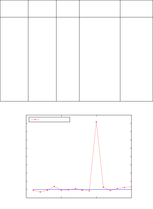
582 m and the median from step 4, for outlier free case. The combinatorial algo-
rithm diagnoses the poor geometry of the 10th combination. Figure 16.6 indicates
the plotted deviations versus combinatorials.
16-2 Algebraic diagnosis of outliers 297
Table 16.4. Positional norms and deviations from the norms of adjusted value and
median (multipath fre e)
Combination Combination Positional Deviation from the the norm of
Number norm (km) norm of the Deviation from
adjusted value (m) the median (m)
1 23-9-5-1 6369.544 -39.227 -17.458
2 23-9-5-21 6369.433 -149.605 -127.837
3 23-9-5-17 6369.540 -43.255 -21.487
4 23-9-1-21 6369.768 185.342 207.110
5 23-9-1-17 6369.538 -44.603 -22.835
6 23-9-21-17 6369.561 -21.768 0.000
7 23-5-1-21 6369.630 47.449 69.217
8 23-5-1-17 6369.542 -41.229 -19.461
9 23-5-21-17 6369.507 -76.004 -54.235
10 23-1-21-17 6373.678 4094.748 4116.516
11 9-5-1-21 6369.724 140.976 162.744
12 9-5-1-17 6369.522 -60.746 -38.978
13 9-5-21-17 6369.648 64.830 86.598
14 9-1-21-17 6369.712 128.522 150.2908
15 5-1-21-17 6369.749 166.096 187.865
0 5 10 15
−500
0
500
1000
1500
2000
2500
3000
3500
4000
4500
Deviation of positional norm without outlier
Combinatorial No.
Deviation in (m)
Outlier diagnosis
Figure 16.6. Deviations of the combinatorial positional norms from that of the adjusted
value (outlier free observation).
Example 16.6 (Case B: Multipath error of 500 m in pseudo-range measurements
from satellite 23). Let us assume that satellite number 23 had its pseudo-range
longer by 500 m owing to multipath effect. Once the positions have been computed
for the various combinations in Table 12.2, the positional norms for the 15 combi-
natorials are then computed via (16.2). The computed deviations of the positional

298 16 Algebraic diagnosis of outliers
norms from the norm of the adjusted value 6368.785 m, norm of the median value
of 6368.638 m and a priori norm from case A are presented in Table 16.5. The
deviations from a priori norm in case A are plotted in Fig. 16.7.
Given that there exists an outlier in the pseudo-range measurements from
satellite 23, which appears in combinations 1 to 10, one expects the deviation in
positional norms in these combinations to contain higher fluctuations than the
combinations without satellite 23. Values of Table 12.2 columns four, five and six
indicate that whereas combinations 11, 12, 13, 14 and 15 without satellite number
23 have values with less fluctuation of positional norms, the variation of the first
10 combinations containing satellite 23 were having larger fluctuations. The case is
better illustrated by Fig. 16.7, where prior information is available on the desired
position (e.g., from the norm of outlier free observations in Example 16.5). In such
case, it becomes clearer which combinations are contaminated. From the figure,
the first 10 combinations have larger deviations as opposed to the last 5, thus
diagnosing satellite 23 as the outlying satellite. In practice, such prior information
can be obtained from e xisting maps.
Table 16.5. Positional norms and dev iations from the norms of adjusted value, median
norm and the norm of case A (Multipath error of 500 m in satellite 23)
Comb. Combination Positional Deviation from norm of Deviation from
No. norm (km) norm of Dev iation from a priori norm
adjusted value (m) the median (m) (m)
1 23-9-5-1 6368.126 -658.763 -512.013 -1456.925
2 23-9-5-21 6367.147 -1637.513 -1490.763 -2435.675
3 23-9-5-17 6368.387 -397.366 -250.616 -1195.528
4 23-9-1-21 6370.117 1332.597 1479.347 534.435
5 23-9-1-17 6368.475 -309.906 -163.155 -1108.068
6 23-9-21-17 6368.638 -146.750 0.000 -944.912
7 23-5-1-21 6368.895 110.069 256.820 -688.093
8 23-5-1-17 6368.256 -528.806 -382.055 -1326.967
9 23-5-21-17 6368.006 -779.197 -632.447 -1577.359
10 23-1-21-17 6368.068 -716.569 -569.818 -1514.730
11 9-5-1-21 6369.724 939.136 1085.888 140.976
12 9-5-1-17 6369.522 737.416 884.166 -60.746
13 9-5-21-17 6369.648 862.991 1009.742 64.829
14 9-1-21-17 6369.712 926.684 1073.434 128.522
15 5-1-21-17 6369.749 964.258 1111.008 166.096
Example 16.7 (Case C: Multipath error of 200 m in satellite 9). Let us now sup-
pose that satellite number 9 appearing in the last 5 combinations in cas e B (i.e.,
combinations 11, 12, 13, 14 and 15) has outlier of 200 m. The positional norms for
the 15 combinatorials are then computed from (16.2). The computed deviations of
the positional norms from the norm of the adjusted value 6369.781 m, norm of the
median value 6369.804 m and a priori norm from case A are presented in Table 16.6
16-2 Algebraic diagnosis of outliers 299
0 5 10 15
−2500
−2000
−1500
−1000
−500
0
500
1000
Deviation of positional norm (outlier of 500m in satellite 23)
Combinatorial No.
(Deviation) m
Outlier diagnosis
Figure 16.7. Deviations of combinatorial positional norms from the norm of the a priori
value in case A (error of 500m in pseudo-range of satellite 23)
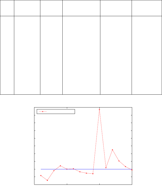
and plotted in Fig. 16.8. Satellite 9 appears in combinations 1, 2, 3, 4, 5, 6, 11, 12,
13, 14 and 15, with larger deviations in positional norms as depicted in Table 16.6
columns four, five and six and plotted in Fig. 16.8. Whereas combinations 7, 8, 9
and 10 without satellite number 9 have values with less deviations of p ositional
norms, the deviations of the first 6 combinations and those of combinations 11-15
containing satellite 9 were larger. With prior information as shown in Fig. 16.8,
satellite 9 can then be isolated to be the satellite with outlier. The value of com-
binatorial 10 is due to poor geometry as opposed to outlier since this particular
combination does not contain satellite 9. This can be confirmed by inspecting the
coefficients of the quadratic equations used to solve the unknown pseudo-range
equations as already discussed in Example 12.2 on p. 181.
The diagnosed outliers in planar ranging observations as well as the pseudo-ranges
of satellites 23 and 9 could therefore either;
• be eliminated from the various combinations and the remaining observations
used to estimate the desired parameters or,
• the effect of the outlier could be managed using robust estimation techniques
such as those discussed in [19, 20, 416], but with the knowledge of the contam-
inated observations.
300 16 Algebraic diagnosis of outliers
Table 16.6. Positional norms and dev iations from the norms of adjusted value, median
norm and the norm of case A (Multipath error of 200m in satellite 9)
Comb. Combination Positional Deviation from norm of Deviation from
No. norm (km) norm of Dev iation from a priori norm
adjusted value (m) the median (m) (m)
1 23-9-5-1 6369.386 -394.656 -417.522 -196.748
2 23-9-5-21 6369.075 -705.644 -728.511 -507.737
3 23-9-5-17 6369.699 -81.796 -104.6639 116.111
4 23-9-1-21 6370.019 238.062 215.195 435.969
5 23-9-1-17 6369.804 22.866 0.000 220.774
6 23-9-21-17 6369.825 44.237 21.371 242.145
7 23-5-1-21 6369.630 -150.459 -173.325 47.449
8 23-5-1-17 6369.542 -239.137 -262.003 -41.229
9 23-5-21-17 6369.507 -273.911 -296.778 -76.004
10 23-1-21-17 6373.678 3896.840 3873.974 4094.748
11 9-5-1-21 6369.894 113.076 90.209 310.983
12 9-5-1-17 6371.057 1276.444 1253.578 1474.352
13 9-5-21-17 6370.333 552.230 529.364 750.138
14 9-1-21-17 6369.966 184.890 162.024 382.798
15 5-1-21-17 6369.749 -31.811 -54.678 166.096
0 5 10 15
−1000
−500
0
500
1000
1500
2000
2500
3000
3500
4000
Deviation of positional norm (outlier of 200m in satellite 9)
Combinatorial No.
(Deviation) m
Outlier diagnosis
Figure 16.8. Deviations of combinatorial positional norms from the norm of the a priori
value (error of 200m in pseudo-range of satellite 9)
16-3 Concluding remarks
The success of the algebraic Gauss-Jacobi combinatorial algorithm to diagnose
outliers in the cases considered is attributed to its computing engine. The capabil-
ity of the powerful algebraic tools of Groebner basis and polynomial resultants to
16-3 Concluding remarks 301
solve in a close form the nonlinear systems of equations is the key to the success
of the algorithm. With prior information from e.g., existing maps, the method
can further be enhanced. For the 7-parameter datum transformation problem dis-
cussed in the next chapter, Procrustes algorithm II could be used as the computing
engine instead of Groebner basis or polynomial resultants. The algebraic approach
presented could be developed to further e nhance the statistical approaches for
detecting outliers.

17 Datum transformation problems
17-1 The 7-parameter datum transformation and its
importance
The 7-parameter datum transformation C
7
(3) problem involves the determination
of seven parameters required to transform coordinates from one system to an-
other. The transformation of coordinates is a computational procedure that m aps
one set of coordinates in a given system onto another. This is achieved by translat-
ing the given system so as to cater for its origin with respect to the final system,
and rotating the system about its own axes so as to orient it to the final sys-
tem. In addition to the translation and rotation, scaling is performed in order to
match the corresponding baseline lengths in the two systems. The three translation
parameters, three rotation parameters and the scale element comprise the 7 param-
eters of the datum transformation C
7
(3) problem, where one understands C
7
(3)
to be the notion of the seven parameter conformal group in R
3
, leaving “space
angles” and “distance ratios” equivariant (invariant). A mathematical introduc-
tion to conformal field theory is given by [141, 357], while a systematic approach
of geodetic datum transformation, including geometrical and physical terms, is
presented by [188]. For a given network, it suffices to compute the transformation
parameters using three or more coordinates in both systems. These parameters
are then later used for subsequent conversions.
In geodesy and geoinformatics, the 7-parameter datum transformation prob-
lem has gained significance following the advent of Global Navigation Satellites
Systems (GNSS), and particularly GPS. Since satellite positioning operates on a
global reference frame (see e.g., Chap. 10), there often exists the need to transform
coordinates from local systems onto GPS’s World Geodetic System 84 (WGS-84).
Specifically, coordinates can be transformed;
• from map systems to digitizing tables (e.g., in Geographical Information Sys-
tem GIS),
• from photo systems (e.g., photo coordinates) to ground systems (e.g., WGS-
84),
• from local (national) systems to global reference systems (e.g., WGS-84) as in
(14.29) on p. 262,
• from regional (e.g., European Reference Frame EUREF system) to global ref-
erence systems (e.g., WGS-84),
• from local (national) systems to regional reference systems, and
• from one local system onto another local system. In some countries, there exist
different systems depending on p olitical boundaries.
This problem, also known as 7-parameter similarity transformation, has its 7 un-
known transformation parameters related to the known co ordinates in the two
systems by nonlinear equations. These equations are often solved using numer-
ical methods which, as already pointed out in the preceding chapters, rely on
J.L. Awange et al., Algebraic Geodesy and Geoinformatics, 2nd ed.,
DOI 10.1007/978-3-642-12124-1 17,
c
Springer-Verlag Berlin Heidelberg 2010
