Wallace J.M., Hobbs P.V. Atmospheric Science. An Introductory Survey
Подождите немного. Документ загружается.

324 Weather Systems
e. Surface weather
The November 10, 1998 storm produced memorable
weather over many parts of the central United States.
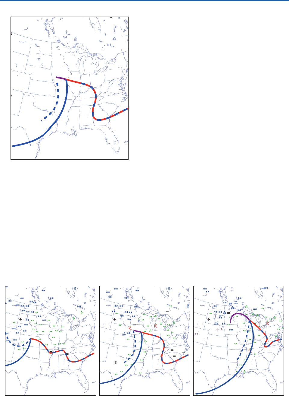
Figure 8.15 shows the distribution of rain, snow, fog,
and thunderstorms at the same times as the charts in
Figs. 8.6 and 8.7. At 00 UTC (18 LT), precipitation
was already widespread in the northeast quadrant of
the storm, with snow to the north and west and rain to
the east and south. With few exceptions, precipitation
–
– 7
–
8
–1
–2
–2
–2
–2
–2
–2
–3
–5
–5
–6
–7
–7
–7
–
8
–
8
2
2
2
2
2
2
6
6
6
4
4
4
4
3
3
5
5
4
–
0
–
0
–
0
–
0
–
0
0
–
0
0
–1
–1
–1
–1 –12
– 9
–
8
– 8
–
0
–
0
0
–
1
–
1
–
1
–
1
– 1
–
1
–
1
–
1
–
1
–
1
–
1
–
1
–
1
–
1
–
1
–
1
–
4
–
5
–
5
–
6
– 7
–
4
– 4
– 1
– 0
0
–
3
–
3
–
2
– 2
–
2
–
1
– 4
–
1
–
1
–
2
–
0
– 0
– 0
–
0
–
0
–
0
–
1
–
3
0
1
1
2
0
– 2
–
0
– 1
– 1
–
2
–
2
–
2
– 2
–
2
7
7
1
1
4
4
6
1
1
1
–1
–1
Fig. 8.14 Sea-level pressure tendency (in hPa) for the 3-h
interval ending 09 UTC Nov. 10, 1998. Heavy lines denote the
frontal positions at this time. [Courtesy of Jennifer Adams,
COLAIGES.]
Fig. 8.15 Surface weather observations of rain, snow, fog, and thunderstorms at 00, 09, and 18 UTC 10 Nov. 1998. For plotting
conventions see Fig. 8.1. [Courtesy of Jennifer Adams, COLAIGES.]
was light at this time. Many stations to the north of the
warm front were reporting fog.
At 09 UTC (03 LT; Fig. 8.15, middle), many of the
stations in the Great Lakes region were reporting
moderate to heavy rain. Snow reported in southern
Minnesota at 00 UTC had changed to rain, reflecting
the northwestward advance of the warmer air in the
northeast quadrant of the storm, and the approach of
the occluded front. The intensity of the snowfall over
the Dakotas had increased and rain had changed to
snow in eastern Nebraska. With nighttime cooling, fog
had become more widespread in the region of the cold
air damming over the Carolinas. Although it is not
apparent on this map, several of the stations in Illinois
and Indiana that reported rain earlier in the evening
experienced intermittent fog later in the night, indica-
tive of the passage of the warm frontal zone. Relative
to 9 h earlier, more stations along and just behind the
cold front were reporting rain at this time.
At 18 UTC (noon LT; Fig. 8.15, right), moderate to
heavy snow was falling across much of the northern
Great Plains, accompanied by strong winds. Hourly
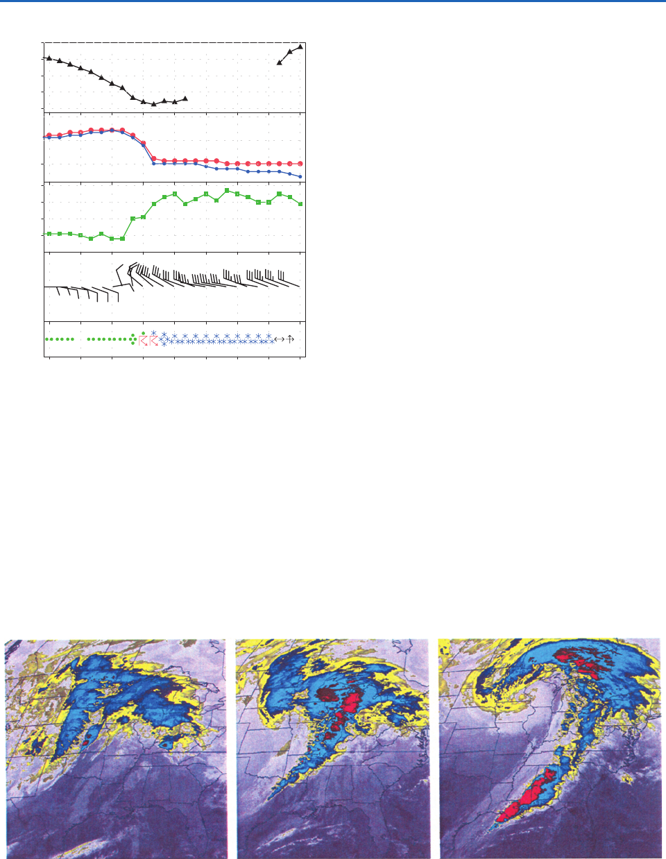
data for Sioux Falls, South Dakota, shown in Fig. 8.16
document blizzard-like conditions prevailing through-
out most of the day. Many of the stations farther to
the east along the advancing cold front experienced
thunderstorms. Although heavy rain continued to be
reported at many stations, the broad current of sub-
siding air circulating around the southern flank of
the cyclone (Fig. 8.5) is reflected in the termination
of precipitation over Illinois and much of Wisconsin.
Marquette, Michigan (Fig. 8.13) experienced a 6-h
lapse in precipitation beginning at 18 UTC.
P732951-Ch08.qxd 9/12/05 7:46 PM Page 324
8.1 Extratropical Cyclones 325
f. Satellite imagery
Infrared satellite imagery shown in Fig. 8.17 provides a
large-scale context for the station observations shown
in the previous figures. The first image (0015 UTC)
shows a band of clouds with relatively cold tops that
accounts for the (mostly light) rain and snow that was
falling in the northeastern part of the storm.The warm
front at this time corresponds fairly closely to the
ragged southern edge of this rain band. Bowling
Green, Kentucky, which experienced the passage of
the front just a few hours later (Fig. 8.11), was not
experiencing rain at this time, but it was located close
to the patch of cold cloud tops along the southeastern
edge of the band. The narrower and somewhat more
coherent band emanating from the cold frontal zone
over the Texas Panhandle and extending northward
toward the Dakotas was evidently responsible for the
light rain at stations in the Texas Panhandle (Figs. 8.8
and 8.15) and Gage, Oklahoma (Fig. 8.10), that was
occurring around this time. The well-defined leading
edge of this band, which appears as a narrow white
line over Texas and as a thin yellow band over
Oklahoma, widening into a blue and red “head” near
the position of the surface low in Kansas, marks the
position of the primary cold front. The patch of colder
cloud tops in the northern segment of this band is the
embodiment of a broad current of rising air streaming
northward above the cold front and wrapping around
the developing cyclone to form a comma-shaped
“head.” It is evident from time-lapse imagery that
much of the structure within this air stream can be
identified with the spreading of the “anvils” of convec-
tive clouds. Over the Texas Panhandle, where the con-
vection along the cold front was shallow at this time,
deeper clouds with an associated band of light rain
were located, not along the front, but within the
frontal zone around 150 km to the northwest of the
primary cold front. Hence, these stations experienced
00 UTC
11 Nov.
18090300
10 Nov.
06 12 15 21
Wind speed (kt) Temperature (°C) Pressure (hPa)
Dew point (°C)
1008
1000
992
984
976
5
10
0
40
30
20
10
Fig. 8.16 Hourly surface observations for Sioux Falls, South
Dakota (KSUX in Fig. 8.36) just to the west of the track of
the center of the surface low. Some of the pressure data are
missing. [Courtesy of Jennifer Adams, COLAIGES.]
Fig. 8.17 Infrared satellite imagery for 00, 09, and 18 UTC Nov. 10, 1998, based on radiation in the 10.7-
m channel, in
which the atmosphere is relatively transparent in the absence of clouds. Radiances, indicative of equivalent black-body tempera-
tures T
E
of the Earth’s surface or the cloud top, are rendered on a scale ranging from black for the highest values (indicative of
cloud-free conditions and a warm surface) with progressively lighter shades of gray indicative of lower temperatures and higher
cloud tops. Color is used to enhance the prominence of the coldest (highest) cloud tops in the image.
P732951-Ch08.qxd 9/12/05 7:46 PM Page 325
326 Weather Systems
a period of rain that began a few hours after the
frontal passage.
At the time of the second image (09 UTC, Fig. 8.17,
middle) the irregularly shaped cloud mass in advance
of the warm front has moved northeastward into the
southern Great Lakes and has assumed a “comma
shape” as it wraps around the northern flank of the
intensifying cyclone. The expansion of the area of blue
shading over the Dakotas and Nebraska in the “head”
of the comma is indicative of a thickening of the cloud
deck over that region, consistent with the increase in
the rate of snowfall from 00 to 09 UTC (Figs. 8.15 and
8.16). Stations in Illinois and Indiana that were under
the cloud deck in the warm frontal zone and experi-
encing rain at 00 UTC were free of middle and high
clouds at 09 UTC, with the clearing coinciding roughly
with the passage of the warm front. An important
aspect of the development of the cloud pattern in the
interval from 00 to the 09 UTC is the pronounced low-
ering of the cloud top temperatures along the leading
edge of the cold frontal cloud band, indicative of the
deepening of the convection. As was the case at 00
UTC, this feature coincides with the primary cold
front. The remnants of the cloud band that was over
the Texas Panhandle at 00 UTC have become aligned
with the secondary cold front.
In the final image in Fig. 8.17 at 18 UTC, the
“yin-yang” signature in the vertical velocity field
(Fig. 8.5, right panel) is clearly evident. The streamer of
clouds emanating from the band of convection along
the cold front curves cyclonically around the north side
of the (now fully developed) cyclone and spirals inward
around its western flank, where heavy snow is falling at
this time.
2
Meanwhile, the equally pronounced current
of darker-shaded subsiding air is wrapping around the
southern flank of the cyclone, bringing an end to the
precipitation in the areas immediately to the south and
east of it. Remnants of the warm frontal cloud band can
still be seen advancing northeastward ahead of the sys-
tem, but they are becoming increasingly detached from
the circulation around the cyclone.
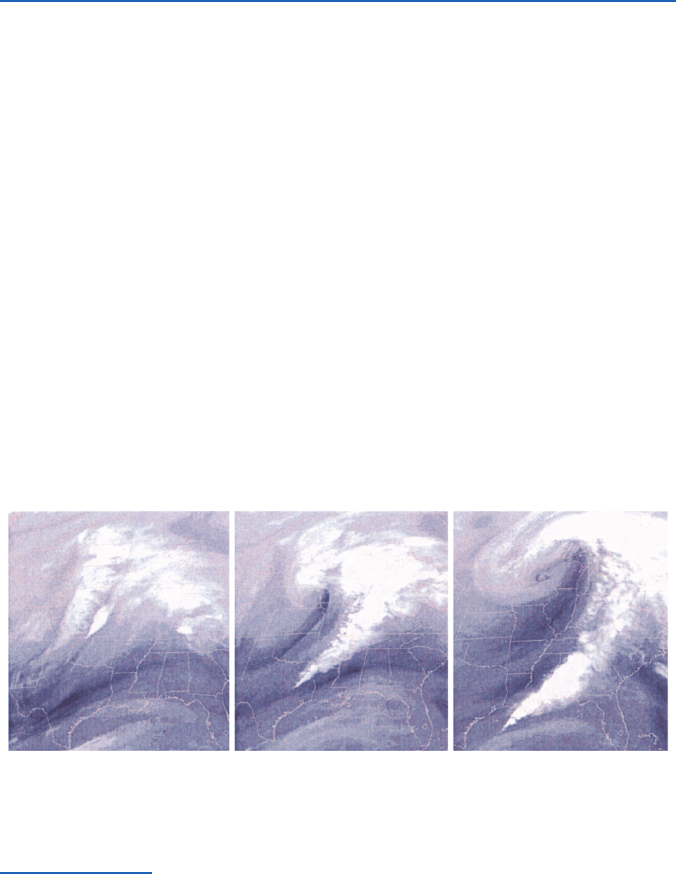
Satellite imagery for the water vapor channel,
shown in Fig. 8.18, yields additional insights into the
structure and evolution of this remarkable storm.
At 00 UTC (left) the deep convective clouds in the
northern segment of the line of convection along the
primary cold front over Kansas are clearly evident.
In this respect, this image and the image from the
2
The fabled “nor’easters” that bury the eastern seaboard of the United States in half-meter-deep snow from time to time exhibit a
structure much like this storm, with the heaviest snowfall in the northwest quadrant of the cyclone. Snowfall tends to be heavier in the
coastal storms than in the storm examined in this chapter because much of the ascending air originates over the warm surface waters of
the Gulf Stream (Fig. 2.5) where dew points are near 20 °C. The biggest snow producers are storms that slow down or execute tight
cyclonic loops during the wrapping-up (or occlusion) process, thereby prolonging the interval of heavy snowfall. For an in-depth discussion
of nor’easters, see P. J. Kocin and L. W. Uccellini, Northeast Snowstorms,Amer. Meteorol. Soc. (2004).
Fig. 8.18 Satellite imagery for 00, 19 and 18 UTC Nov. 10, 1998, based on the 6.7
m “water vapor channel.” The radiances
in this band provide a measure of the mid- and upper tropospheric humidity which, in turn, is determined by the air trajectories.
Air that has been rising tends to be moist, resulting in a high optical depth, a low equivalent blackbody temperature and a low
radiance, and vice versa. Low radiances, indicative of ascent are rendered by the lighter gray shades and high radiances, indica-
tive of subsidence, by the darker shades. The brightest features in the images are clouds with high, cold tops.
P732951-Ch08.qxd 9/12/05 7:46 PM Page 326
8.1 Extratropical Cyclones 327
10.7-
m channel, shown in the previous figure, are
similar. However, as one follows the front southward
through Oklahoma and into Texas, the shallower
clouds are masked by the overlying water vapor
distribution, which is indicative of a narrow band
of subsiding air almost directly above the front.
A prominent feature in the water imagery for the
water vapor channel is the so-called dry slot, which
first becomes apparent in the 09 UTC image and
subsequently expands as it wraps around the cyclone.
In some storm systems the dry slot is much more
prominent in the imagery for the water vapor chan-
nel than in that for the 10.7-
m channel. The light
gray shading over the Gulf of Mexico is indicative of
a deep layer of moist, subtropical air that becomes
entrained into the storm as it develops, fueling deep
convection along the cold front.
g. Radar imagery
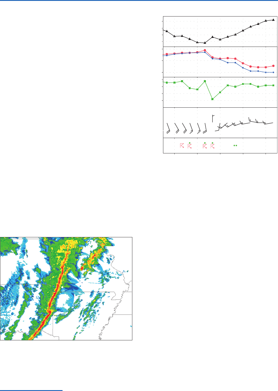
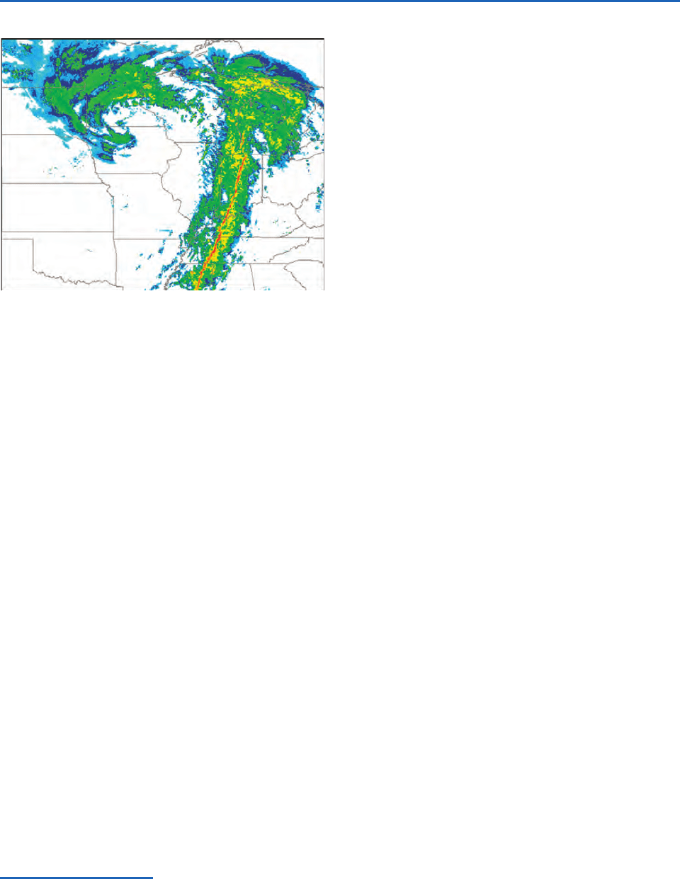
Composite radar imagery shown in Figs. 8.19 and
8.21 confirms the existence of a narrow, persistent
band of deep convection, a feature commonly
referred to as a squall line, which, in this storm, is
coincident with the advancing cold front.
3
Rainfall
rates are heaviest along the leading edge of the line
and trail off gradually behind it. Figure 8.20 shows
hourly surface reports for Springfield, Missouri,
located just to the east of the position of the squall
line at 0620 UTC, the time of Fig. 8.19. Springfield
reported thunder at 04 and 05 UTC and then again
at 07 and 08 UTC. The later event marks the pas-
sage of the squall line in Fig. 8.19. Some time
between the 07 and the 08 observations at
Springfield, the temperature dropped by 7 °C and
the pressure rose by nearly 4 hPa, signaling a strong
cold frontal passage. The most pronounced shift in
the wind (from SSW to WSW) did not occur at
Springfield until the passage of the secondary cold
front around 2 h later, between 09 and 10 UTC, and
it was not until that time that the barometer began
to rise unequivocally. The drop in temperature and
dew point did not resume until between 11 and 12
UTC, when another much weaker rain band passed
over the station. The narrow band of dry, subsiding
air aloft was also passing over Springfield around 09
UTC (Fig. 8.18, middle).
The second radar image shown in Fig. 8.21, based
on data taken about 9 h later, still exhibits a well-
defined, narrow band of heavy rainfall that is virtu-
ally coincident with the position of the primary cold
3
Squall lines are sometimes observed in the warm sector in advance of, and oriented parallel to, the cold front.
Fig. 8.20 Hourly surface reports for Springfield, Missouri
(KSGF in Fig. 8.36) showing the passage of the squall line and
primary cold front around 07–08 UTC. [Courtesy of Jennifer
Adams, COLAIGES.]
Fig. 8.19 Composite radar image for 0620 UTC Nov. 10,
1998. Estimated rainfall rates increase by about a factor of
five from the faintest echoes, rendered in blue, to the
strongest echoes, rendered in red. The white circle indicates
the location of Springfield, Missouri.
15 UTC12090603
10 Nov.
Wind speed (kt) Temperature (°C) Pressure (hPa)
Dew point (°C)
1008
1004
1000
996
20
10
0
20
15
10
5
P732951-Ch08.qxd 9/12/05 7:46 PM Page 327
328 Weather Systems
front. The major features in the distribution of radar
echoes mirror the patterns in the 18 UTC satellite
imagery, i.e., the comma-shaped cloud band emerging
from the southern tip of the squall line and wrapping
around the poleward flank of the cyclone and the
slot of dry, relatively cloud-free air intruding from the
west and wrapping around the equatorward and east-
ern flank of the cyclone. This “yin-yang”-like configu-
ration is the signature of intertwined ascending and
descending air currents in the vertical velocity field
shown in the right-hand side of Fig. 8.5.
8.1.3 Vertical Structure
This subsection examines the vertical structure of this
intense baroclinic wave using data formatted in three
different ways: upper level charts at selected pressure
levels, vertical soundings for selected radiosonde sta-
tions, and vertical cross sections.
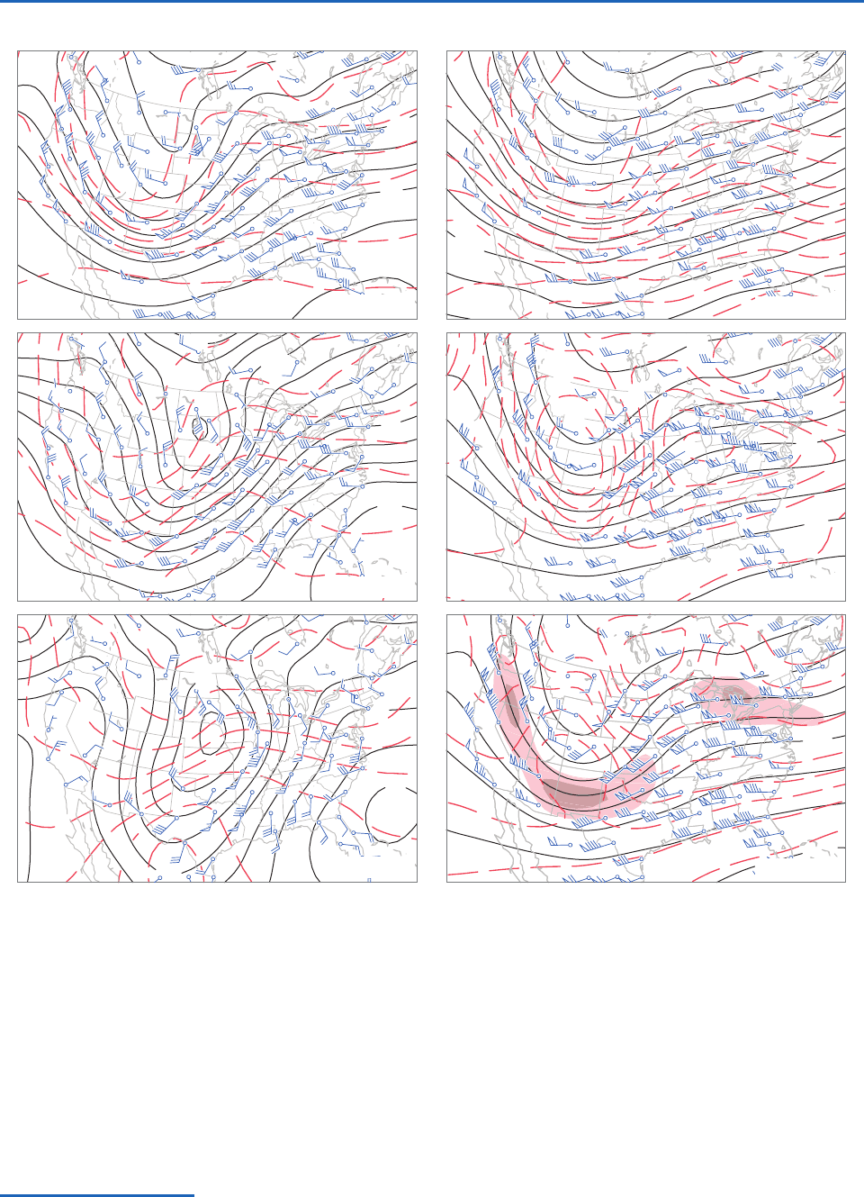
a. Upper level charts
Figure 8.22 shows a series of upper level charts for
00 UTC Nov. 10, around the time when the associ-
ated extratropical cyclone was beginning to deepen
rapidly. The corresponding sea level pressure and
surface air temperature patterns have already been
shown in Figs. 8.6 and 8.7. The 850-hPa height gra-
dients tend to be stronger than the gradients in
sea-level pressure (or 1000-hPa height) at the same
location.
4
Stronger height gradients are indicative of
higher geostrophic wind speeds. Comparing the
numbers of wind barbs on the shafts in Figs. 8.6 and
8.22, it is evident that the actual winds are stronger
at the 850-hPa level as well. Based on the thermal
wind equation (7.20) we know that the strengthen-
ing of the westerly component of the wind from the
surface to the 850-hPa level is consistent with the
prevailing meridional temperature gradient in this
layer, with colder air to the north. When the differ-
ences in contour intervals in the charts are taken
into account, it is readily verified that the geopoten-
tial height gradients and wind speeds increase con-
tinuously with height up to the 250-hPa level, which
corresponds to the level of the jet stream in Fig. 1.11.
From 250 to 100 hPa, the highest level shown, the
gradients and wind speeds decrease markedly with
height.
The 850-hPa isotherms tend to be concentrated
within the frontal zone extending from the Great
Plains eastward to the Atlantic seaboard and passing
through the surface low. To the east of the surface
low, southerly winds are advecting the frontal zone
northward, whereas to the south of the surface
low, westerly winds are advecting it eastward. The
frontal zone is particularly tight in the region of cold
advection to the south of the surface low, and the
temperature is remarkably uniform within a well-
defined warm sector to the southeast of the surface
low. The 850-hPa height contours that pass through
the frontal zone exhibit strong cyclonic curvature.
5
Over the Carolinas the warm frontal zone on the
850-hPa chart is positioned quite far to the north of
its counterpart on the surface charts. This northward
displacement reflects the shallowness of the layer of
trapped cool air to the east of the Appalachian
mountain range.
Proceeding upward from the 850-hPa to the
250-hPa level, the patterns exhibit notable changes.
4
From the hypsometric equation it is readily verified that the conventional 4-hPa contour interval for plotting sea-level pressure is
roughly comparable to the 30-m contour interval used for plotting the 850-hPa height. Hence, the relative strength of the pressure gradient
force (and the geostropic wind) at the two levels can be assessed qualitatively simply by comparing the spacing of the isobars and height
contours.
5
Frontal zones at any level are generally characterized by strong cyclonic vorticity. In stationary frontal zones the vorticity is manifested
in the form of shear rather than curvature.
Fig. 8.21 Composite radar image for 1535 UTC Nov. 10,
1998.
P732951-Ch08.qxd 9/12/05 7:46 PM Page 328
8.1 Extratropical Cyclones 329
As noted previously, the geopotential height gradi-
ents and the associated geostrophic winds generally
increase with height
6
and this tendency is mirrored in
the strength of the observed winds. The trough in the
geopotential height field tilts westward with height
by around 14 wavelength from the surface up to the
500-hPa level, but it exhibits relatively little vertical
tilt above that level.
500 hPa
558
576
700 hPa
850 hPa
100 hPa
250 hPa
540
–
28
–
16
–
8
8
0
138
153
159
8
16
147
–
8
–
16
–
8
294
306
318
285
1140
1628
1614
1590
1188
1224
996
1056
1020
1092
–
62
–
56
–
68
–
72
–
54
–
58
–
50
–
60
–
64
–
56
–
60
–
56
–
52
–
48
0
200 hPa
Fig. 8.22 Upper level charts for 00 UTC Nov. 10, 1998, showing geopotential height (black contours), temperature (red con-
tours), and observed winds. Contour interval 30 m for 850- and 700-hPa height, 60 m for 150-hPa height, 120 m for 250- and
200-hPa height, and 60 m for 100-hPa height. The contour interval for temperature is 4 °C in the left panels and 2 °C in the
right panels. The shading in the 250-hPa chart are isotachs defining the position of the jet stream. Conventions for plotting wind
vectors are shown in Fig. 8.1. [Courtesy of Jennifer Adams, COLAIGES.]
6
In visually comparing the pressure gradients at the various levels, bear in mind that the contour interval doubles from the 700- to the
500-hPa level and doubles again from the 500- to the 250-hPa level.
P732951-Ch08.qxd 9/12/05 7:46 PM Page 329
330 Weather Systems
The temperature contrast between the cold air
mass over western Canada and the warm air mass
over the subtropics gradually weakens with height.
The orientation of the isotherms is much the same at
the lowest three levels. Hence the expression of the
baroclinic wave in the temperature field does not tilt
westward with height. In most extratropical cyclones
the baroclinic zones weaken and become progres-
sively more diffuse as one ascends from the Earth’s
surface to the 500-hPa level. In this particular storm,
the warm frontal zone weakens with height but
the cold frontal zone remains quite strong up to the
500-hPa level. Upon close inspection it is evident that
both warm and cold frontal zones slope backward
toward the cold air with increasing height. The
horizontal temperature advection within the frontal
zones weakens with height as the wind vectors come
into alignment with the isotherms. In contrast to
the patterns at 850 and 700 hPa, which are highly
baroclinic, the structure at the higher levels is more
equivalent barotropic.
The temperature patterns in the lower strato-
sphere are weak and entirely different from those
in the troposphere. At these levels (Fig. 8.22, right)
the air in troughs in the geopotential height field
tends to be warmer than the surrounding air, and the
air in ridges tends to be cold. From the hypsometric
equation it follows that the amplitudes of the ridges
and troughs must decrease with height, consistent
with the observations. By the time one reaches the
100-hPa level the only vestige of the baroclinic wave
that remains is the weak trough over the western
United States.
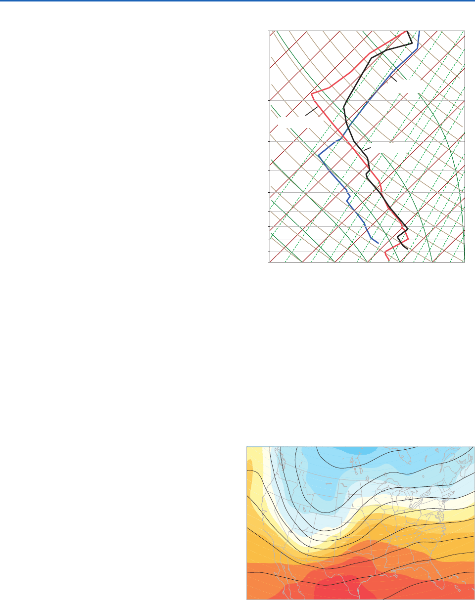
Now let us examine the structure of the tropopause
in this high amplitude baroclinic wave. Vertical tem-
perature profiles for stations in the trough and ridge
of the wave are contrasted in Fig. 8.23.The profile for
Denver, Colorado, which is located near the center of
the 250-hPa trough, is relatively cold throughout the
depth of the troposphere. The tropopause is marked
by a sharp discontinuity in lapse rate around the
350-hPa (8 km) level, with a transition to more
isothermal conditions above. In contrast, the profile
for Davenport, Iowa, which is located in the 250-hPa
ridge, exhibits a much colder and even sharper
tropopause 180 hPa (12.5 km).The tropopause tem-
perature at this time was 20 °C colder at Davenport
than at Denver. Stations such as Amarillo, Texas,
which lie close to the axis of the jet stream, exhibit a
more gradual decline in the lapse rate as one ascends
from the troposphere into the stratosphere. The
tropopause is not as well-defined in the Amarillo
sounding as it is in the other two soundings.
Figure 8.24 shows how the tropopause structure
relates to the lower tropospheric temperature
Davenport
Denver
Amarillo
100
200
300
400
500
600
700
800
900
1000
–
30
– 20
– 10
0
10
20
30
Fig. 8.23 Vertical temperature soundings for Denver,
Colorado (blue line), Amarillo, Texas (black line), and
Davenport, Iowa (red line) at 00 UTC Nov. 10, 1998, plotted
on a skew T – In p diagram. [Courtesy of Jennifer Adams,
COLAIGES.]
–53
–62
–67
–64
–69
–48
–52
–52
–52
300
350
350
350
320
200210
220
180
Fig. 8.24 Height contours for the 250-hPa surface superim-
posed on 1000- to 500-hPa thickness (indicated by colored
shading) as in Fig. 8.3 for 00 UTC Nov. 10, 1998. For selected
stations, tropopause temperatures (TT in °C) and pressures
(PPP in hPa) are plotted (TTPPP). [Courtesy of Jennifer
Adams, COLAIGES.]
P732951-Ch08.qxd 9/12/05 7:46 PM Page 330
8.1 Extratropical Cyclones 331
pattern and the flow at the jet stream level
(250 hPa). The ridge and trough in the 250-hPa
height pattern correspond, respectively, to the
axes of the warmest and coldest air in the 1000- to
500-hPa thickness pattern, and the jet streams
overlie the baroclinic zones, with colder air lying to
the left. The depression of the tropopause in the
vicinity of the 250-hPa trough, and directly above
the cold air mass in the lower troposphere, is
indicative of large-scale subsidence, as required by
the continuity of mass [Eq. (7.39), Fig. 7.18]; i.e.,
as the cold air mass in the lower troposphere
spreads out horizontally (as evidenced by the rapid
advance of the surface cold front), the air above
it must sink. The relatively high tropopause tem-
peratures observed at stations deep within the cold
air mass are due to the adiabatic warming of the
subsiding air. At the 250-hPa level, relative humidi-
ties at these stations (not shown) were in the
25–40% range, consistent with a recent history of
subsidence. In contrast, within the relatively warm,
ascending air stream over the northern Great
Plains, the tropopause is elevated; tropopause tem-
peratures are relatively cold, and relative humidi-
ties are 80%. Figure 8.24 also suggests a possible
explanation of why the tropopause in the Amarillo
sounding is not as clear as in the soundings for
the other two stations shown in Fig. 8.23. Note
that Amarillo lies along the axis of the jet stream,
where the tropopause is like a vertical wall, with
tropospheric air on the anticyclonic side and
stratospheric air on the cyclonic side.
b. Frontal soundings
This subsection examines vertical profiles of wind,
temperature, and dew point in the lower troposphere
at representative stations in different sectors of the
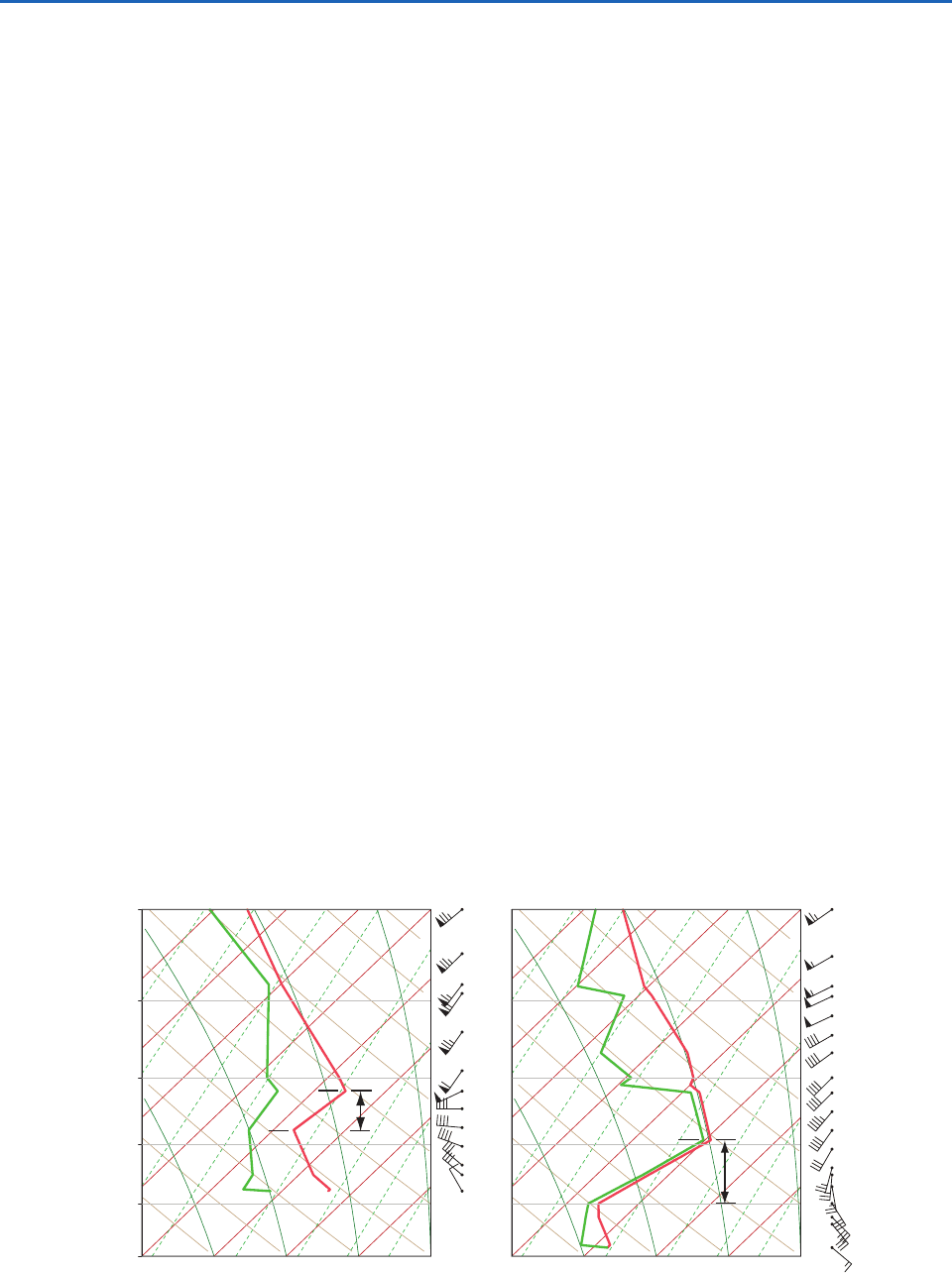
developing cyclone. Soundings for two stations within
the frontal zone are shown in Fig. 8.25. Amarillo lies
within the segment of the frontal zone to the south of
the surface low. In the Amarillo sounding the wind
backs (i.e., turns cyclonically) with increasing height
in the layer extending from the surface nearly up to
the 700-hPa level. The backing is strongest in the
inversion later extending from 780 to 720 hPa. Based
on the thermal wind equation [Eq. (7.20)], backing
implies cold advection. The layer of strong backing
thus corresponds to the cold frontal zone and the cold
front intersects the sounding at the top of the layer
of strong backing at 720 hPa. Davenport lies in
an analogous position within the frontal zone to the
east of the surface low, where the warm air is being
advected northward by the southerly component of
the wind. In the Davenport sounding the wind veers
(turns anticyclonically) with increasing height, indi-
cative of warm advection, from the surface up to
800 hPa, which marks the position of the warm front.
In both the soundings shown in Fig. 8.25, the frontal
zone corresponds to a layer of strong vertical wind
Amarillo Davenport
front
frontal
zone
front
frontal
zone
0
5
10
15
20
500
600
700
800
900
1000
0
5
10
15
20
Fig. 8.25 Soundings of wind, temperature (red lines), and dew point (green lines) at 00 UTC Nov. 10, 1998 at Amarillo,
Texas (left) in the cold frontal zone and Davenport, Iowa (right) in the warm frontal zone. [Courtesy of Jennifer Adams,
COLAIGES.]
P732951-Ch08.qxd 9/12/05 7:46 PM Page 331
332 Weather Systems
shear and high static stability, as evidenced by the
presence of temperature inversions.
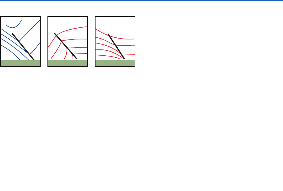
The idealized frontal cross sections shown in
Fig. 8.26 are helpful in interpreting the frontal
soundings. Consistent with the definition in Sec-
tion 8.1.2b, at any given level the front marks the
warm air boundary of the frontal zone. Consistent
with Fig. 8.22, the front slopes backward, toward
the colder air, with increasing height. Consistent with
Fig. 8.25 the front marks the top of the frontal zone;
it is characterized by high static stability and strong
vertical wind shear. The frontal zone is depicted as
being sharpest at the surface.
Soundings for stations located in the warm sector
of the developing cyclone (not shown) exhibit little
turning of wind with height other that the frictional
veering just above the surface, and relatively little
increase of wind speed with height. Stations in the
cold sector to the west or northwest of the surface low
exhibit relatively little turning of the wind with height,
but in some storms they reverse direction, from north-
easterly at low levels to southwesterly aloft.
c. Vertical cross sections
Vertical cross sections are the natural complement to
horizontal maps in revealing the three-dimensional
structure of weather systems. A generation ago, the
construction of cross sections was a labor-intensive
process that involved blending temperatures and
geostrophic winds derived from constant pressure
charts with wind and temperature data for interme-
diate levels extracted from soundings for stations
lying along the section. Interpolating fields in the
gaping holes between data points could be a formi-
dable challenge, even for the skilled analyst. With
today’s high-resolution gridded data sets generated
by sophisticated data assimilation schemes, all the
analyst need do to generate a section is to specify the
time and orientation and the fields to be included.
The two most widely used variables in vertical cross
sections are temperature (or potential temperature)
and geostrophic wind. The sections are usually oriented
normal to the jet stream in which case, isotachs of the
wind component normal to (or through) the section
reveal the location and strength of the jet stream where
it passes through the plane of the section, and they
often capture the zones of strongest vertical wind shear,
where patches of clear air turbulence tend to be con-
centrated. If the flow through the section is not strongly
curved, then the vertical shear of the geostrophic wind
component normal to the section and the horizontal
temperature gradient along the section are approxi-
mately related by the thermal wind equation
(8.1)
where V
n
is the geostrophic wind component into
the section and T
n
is temperature in the plane of the
section, with the horizontal coordinate s defined as
increasing toward the right. Hence, at any point in the
section the horizontal temperature gradient is directly
proportional to the vertical wind shear. It follows that
the horizontal spacing of the isotherms is directly
proportional to the vertical spacing of the isotachs
plotted in the section. For example, in regions of the
section in which the flow is barotropic, the isotherms
(or isentropes) are horizontal (i.e.,
T
s 0) and the
isotachs are vertical (i.e.,
V
n
p 0). These condi-
tions also apply locally in the core of a jet stream.
Near the tropopause, the vertical wind shear and the
horizontal temperature gradient both undergo a sign
reversal at the same level, at which point the isotachs
are vertical and the isotherms are horizontal.
The same relationships apply to vertical wind shear
and the horizontal gradient of potential temperature.
Vertical cross sections for temperature and potential
temperature tend to be somewhat different in appear-
ance because temperature in the troposphere usually
decreases with height, whereas potential temperature
increases with height, and in the stratosphere
p is
always strong and negative, whereas
T
p is often
weak and may be of either sign.
V
n
p
R
fp
T
n
s
Isotachs
+
Isotherms Isentropes
+
+
–
–
–
Fig. 8.26 Idealized representations of a sloping frontal zone
looking downwind at the jet stream level in the northern hemi-
sphere (or upwind in the southern hemisphere). (Left) The
wind component directed normal to the section: values into
the section are denoted as positive. (Middle) Temperature.
(Right) Potential temperature. Plus () and minus () signs
indicate the polarity of the gradients (e.g., in the left the wind
component into the section increases with height).
P732951-Ch08.qxd 9/12/05 7:46 PM Page 332
8.1 Extratropical Cyclones 333
Another variable that is frequently plotted in vertical
cross sections is isentropic potential vorticity,
(8.2)
as defined in Section 7.2.10. PV is a conservative
tracer that serves as a marker for intrusions of
stratospheric air into the troposphere in the vicinity
of the jet stream. Air that has resided in the strato-
sphere for any appreciable length of time acquires
high values of static stability
p by virtue of the
vertical gradient of diabatic heating at those levels.
Hence, the potential vorticity of stratospheric air
tends to be much higher than that of tropospheric
air. When a layer of stratospheric air is drawn down-
ward into the troposphere, columns are stretched
in the vertical, pulling the potential temperature
surfaces apart, thereby causing the static stability to
decrease. Conservation of potential vorticity requires
that the vorticity of the air within the layer becomes
more cyclonic as it is stretched in the vertical.
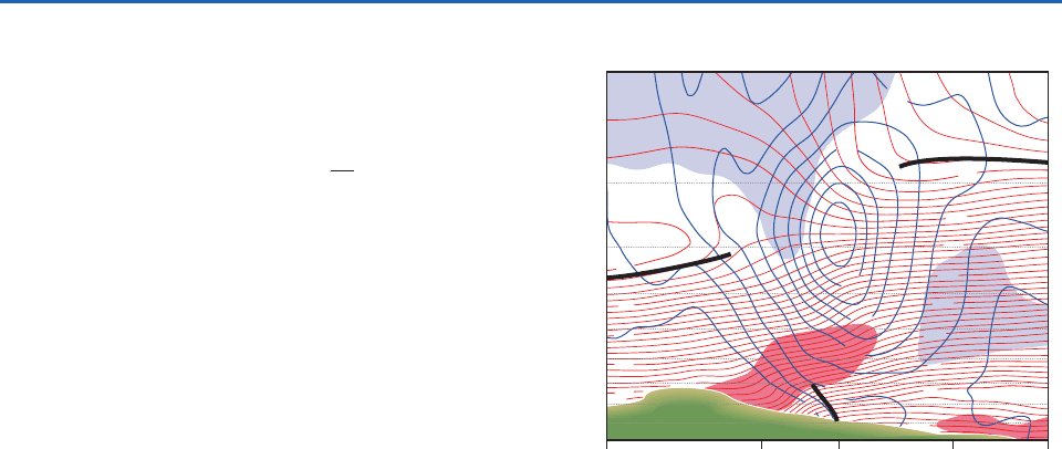
Now let us consider two examples of vertical cross
sections. The first example, shown in Fig. 8.27, is ori-
ented perpendicular to the cold front and jet stream
over the southern Great Plains at 00 UTC. The
viewer is looking downstream (i.e., northeastward):
the colder air is toward the left. In denoting positions
along the section, we will be referring to a series of
imaginary stations, indicated by letters A, B ...etc.
along the baseline of the section. The front at the
Earth’s surface is at C and the frontal zone is appar-
ent to the west of station C as a wedge of sloping
isotherms (i.e., the red contours) and strong vertical
wind shear, as indicated by the close spacing of the
isotachs (blue contours) in the vertical. Consistent
with the idealized depictions in Fig. 8.26, the front
(i.e., the warm air boundary of the frontal zone)
slopes backward, toward the cold air, with increasing
height. The front becomes less clearly defined at
levels above 700 hPa.The jet stream with a maximum
wind speed of nearly 50 m s
1
passes through the
section above station C at the 250-hPa level.
The tropopause is clearly evident in Fig. 8.27 as a
discontinuity in the vertical spacing of the isotherms:
in the troposphere the isotherms are closely spaced
in the vertical, indicative of strong lapse rates, while
in the stratosphere, they are widely spaced, indicative
of nearly isothermal lapse rates. Consistent with
Fig. 8.24, the tropopause is low and relatively warm
on the cyclonic (left) side of the jet stream and high
PV
(
f)
p
and cold on the anticyclonic (right) side. An aircraft
flying along the section at the jet stream (250-hPa)
level, passing from the warm side to the cold side of
the lower tropospheric frontal zone, would pass from
the upper troposphere to the lower stratosphere
while crossing the jet stream. Entry into the strato-
sphere would be marked by a sharp decrease in rela-
tive humidity and an increase in the mixing ratio of
ozone. One would also observe a marked increase in
the PV of the ambient air: a consequence of both the
increase in static stability
p (i.e., compare the
lapse rates at the 250-hPa level at stations D and B)
in combination with a transition from weak anticy-
clonic (negative) relative vorticity
on the equator-
ward flank of the jet stream to quite strong cyclonic
(positive) relative vorticity on the poleward flank.
Figure 8.28 shows a vertical cross section normal
to the frontal zone 12 h later. In this section the red
contours are isentropes (rather than isotherms), and
high values of PV, indicative of stratospheric air, are
indicated by shading. The jet stream is stronger in
this section than in the previous one, with peak wind
speeds of 60 m s
1
. Immediately beneath the jet
A B C D E
200–
300–
400–
500–
600–
700–
800–
900–
1000–
100–
J
–10
20
–60
–50
–40
–30
–20
–10
0
10
20
30
40
30
20
10
0
–20
–30
–40
–50
Fig. 8.27 Vertical cross section of wind and temperature for
00 UTC Nov. 10, 1998. This section extends from Riverton,
Wyoming to Lake Charles, Louisiana (KRIW to KLCH; see
Fig. 8.36). Temperature is indicated by red contours, and
isotachs of geostrophic wind speed normal to the section,
with positive values defined as southwesterly winds directed
into the section, are plotted in blue. Regions with relative
humidities in excess of 80% are shaded in red and below
20% in blue. Heavy black lines indicate positions of the
surface-based fronts and the tropopause. The orientation of
the section relative to the front is indicated in Fig. 8.36 at the
end of this section. [Courtesy of Jennifer Adams, COLAIGES.]
P732951-Ch08.qxd 9/12/05 7:46 PM Page 333
