Wallace J.M., Hobbs P.V. Atmospheric Science. An Introductory Survey
Подождите немного. Документ загружается.

314 Weather Systems
the other protrudes northward over Scandinavia.
Pronounced troughs (along which the contours bulge
equatorward) are evident over the Black Sea, Japan,
the central Pacific, and the United States Great
Plains, and several weaker troughs can be identified
at other locations. The typical distance between suc-
cessive troughs (counting the weaker ones) is 50° of
longitude or 4000 km, which corresponds to the theo-
retically predicted wavelength of baroclinic waves.
Time-lapse animations of weather charts like the
one shown in Fig. 8.2 reveal that baroclinic waves
move eastward at a rate of 10 m s
1
, which corre-
sponds to the wintertime climatological-mean zonal
wind speed around the 700-hPa level. Since the
strength of the westerlies generally increases with
height within the extratropical troposphere, air parcels
above this so-called steering level pass through the
waves from west to east, while air parcels below that
level are overtaken by the waves. Successive ridges
(or troughs) typically pass a fixed point on Earth at
intervals of roughly 4 days, but they may be only a
day or two apart if the steering flow is very strong.
T Wind speed (kt)
dd Wind direction
TT Temperature (C)
T
d
T
d
Dew point (C)
PPP Pressure
±ppa Pressure tendency
N Sky cover
ww Weather
RR 6h precipitation (in.)
Plotting model
WIND
SPEED
(T)
5101535 50120
WIND
DIRECTION
(dd)
Northeasterly
(45°)
Northerly
(from the north)
(0° or 360°)
Southeasterly
(135°)
Westerly
(270°)
SKY
COVER
(N)
Clear Scattered
clouds
Broken
clouds
Cloudy Sky obscured (outer
circle denotes calm wind)
WEATHER
(ww)
Light
continuous rain
Moderate
continuous snow
Rain
shower
Past
drizzle
Thunderstorm
Dense
fog
Sleet
or hail
Freezing
drizzle
Blowing
snow
]
TT
ff
ww
T
d
T
d
PPP
±ppa
RR
N
T 15
dd 320
TT 21
T
d
T
d
10
PPP 1024.7
±ppa 0.8 (rising, then steady)
N Clear
ww None
RR None
Example 1
21
10
247
+8
T Calm
dd —
TT –1
T
d
T
d
–1
PPP 1003.7
±ppa 1.8↓
N Sky obscured
ww None
RR 0.15
Example 2
–18\
–1
–1
037
.15
T 5
dd 070
TT 17
T
d
T
d
15
PPP 993.6
±ppa 3.0 (fall, then larger rise)
N Cloudy
ww Thunderstorm in past hour
RR Missing
Example 3
+30
17
15
936
M
]
dd
FRONTS
Cold
Warm
Stationary
Occluded
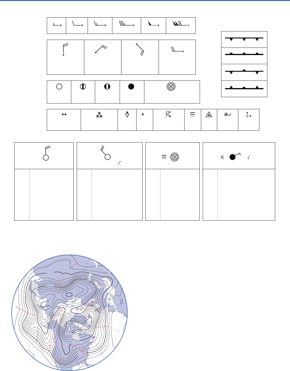
Fig. 8.1 Plotting convections used in synoptic charts.
Fig. 8.2 Hemispheric 500-hPa height chart for 00 UTC
Nov. 10, 1998. Contours at 60-m intervals. Contours labeled
in tens of meters (decameters, dkm). Solid red lines denote
the axes of ridges, and dashed red lines denote the axes of
troughs in the 500-hPa wave pattern. [Courtesy of Jennifer
Adams, COLAIGES.]
570
540
540
510
H
L
L
L
L
510
570
P732951-Ch08.qxd 9/12/05 7:46 PM Page 314
8.1 Extratropical Cyclones 315
Lapses of a week or longer may occur between wave
passages in the sectors of the hemisphere where the
westerlies aloft are blocked by strong ridges. The
direction of propagation tends to follow the steering
flow, which nearly always exhibits a strong eastward
component. Baroclinic waves are observed most
regularly and tend to be strongest over the oceans,
but they can develop over land, as in this case study.
Baroclinic wave activity tends to be most vigorous
during winter when the meridional temperature
gradient across midlatitudes is strongest.
A more detailed view of the 500-hPa height
pattern over the North American sector at 00 UTC
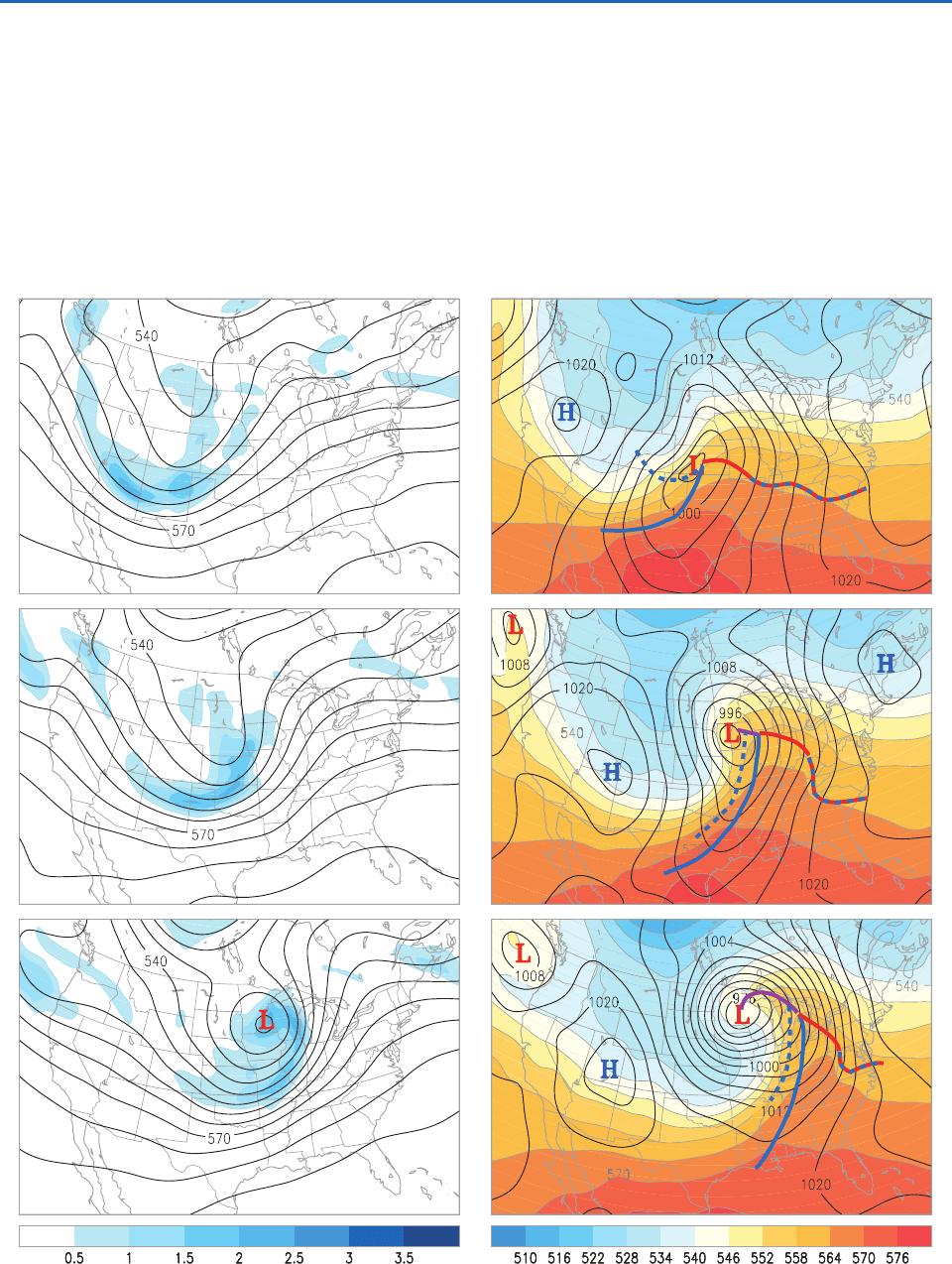
November 10 is shown in Fig. 8.3, and the charts for
Fig. 8.3 Synoptic charts at 00, 09, and 18 UTC Nov. 10, 1998. (Left) The 500-hPa height (contours at 60-m intervals; labels
in dkm) and relative vorticity (blue shading; scale on color bar in units of 10
4
s
1
). (Right) Sea-level pressure (contours
at 4-hPa intervals) and 1000- to 500-hPa thickness (colored shading: contour interval 60 m; labels in dkm). Surface frontal
positions, as defined by a skilled human analyst, are overlaid. [Courtesy of Jennifer Adams, COLAIGES.]
P732951-Ch08.qxd 9/12/05 7:46 PM Page 315

316 Weather Systems
9 and 18 h later are shown below it. Clearly evident
in this three-chart sequence is the eastward propaga-
tion and intensification of the trough that passes over
the United States Great Plains. In the third chart in
the sequence, the base of this trough splits off from
the westerlies to form a cutoff low (i.e., an isolated
minimum in the geopotential height field), implying
the existence of a closed cyclonic circulation. The
dramatic intensification of the winds encircling this
feature is reflected in the tightening of the spacing
between adjacent 500-hPa height contours.
The intensification of the trough at the 500-hPa
level is accompanied by the deepening of the corre-
sponding low pressure center in sea-level pressure
field, as shown in the right-hand panels of Fig. 8.3.
This surface low marks the center of a closed cyclonic
circulation referred to as an extratropical cyclone.
Also evident in the right-hand panels of Fig. 8.3 is
the amplification of the west-to-east gradient in the
1000- to 500-hPa thickness field, indicated by the col-
ored shading. In the first chart of the sequence the
developing surface low is located well to the east of
the corresponding trough in the 500-hPa height field,
but as these features amplify, they come into vertical
alignment in subsequent charts of the sequence.
Now let us examine this sequence of events in
greater detail. Embedded in the long-wave trough
over western North America in the first chart in
the sequence (Fig. 8.3, upper left panel) are several
smaller scale features, which show up clearly in the
vorticity field. The vorticity maxima along the coast
of British Columbia and over northern Arizona
correspond to short-wave troughs, in which the
horizontal flow exhibits both cyclonic curvature and
cyclonic shear. The shear is particularly strong in
the Arizona trough. Nine hours later (Fig. 8.3, middle
left panel) these vorticity maxima and their asso-
ciated troughs appear downstream of their previous
positions: the former is centered over the state of
Washington and the latter has evolved into an elon-
gated comma-shaped band trailing westward from
Kansas, across the Texas Panhandle and into New
Mexico. In the final chart of the sequence, the head
of the comma-shaped feature is centered over south-
eastern Minnesota.
In the corresponding sequence of surface charts
shown in the right-hand panel of Fig. 8.3, the central
pressure of the surface low, as analyzed in Fig. 8.3,
dropped from 998 hPa at 00 UTC Nov. 10 (top panel)
to 978 hPa at 18 UTC (bottom panel), and 968 hPa
at 00 UTC Nov. 11 (not shown), a deepening rate of
30 hPa per day, which is three times as rapid as
observed in a typical extratropical cyclone. At 00
UTC Nov. 10 (Fig. 8.3, top panel) the center of the
extratropical cyclone (as defined by the sea-level
pressure field) was located 14 wavelength down-
stream of the 500-hPa trough and just about directly
underneath the jet stream. In contrast, in the last of
the three charts the surface low was situated almost
directly beneath the cutoff low in the 500-hPa height
field, and on the poleward (cyclonic) side of the jet
stream.
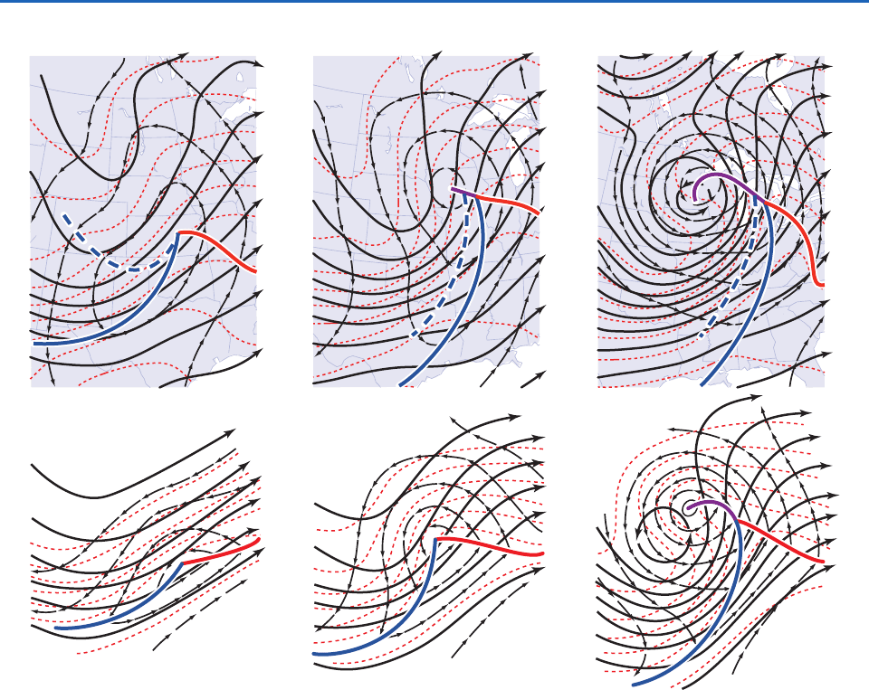
The top panel of Fig. 8.4 shows the same infor-
mation for the same three map times, depicted in a
slightly different way. In this case the geopotential
height field at the Earth’s surface is represented in
terms of the geopotential height of the 1000-hPa
surface. Contours of 1000-hPa height, 500-hPa height
and 1000- to 500-hPa thickness are superimposed on
the same set of charts, with the same (60-m) contour
interval. The lower panels of Fig. 8.4 show the evolv-
ing structure of a typical baroclinic wave, as depicted
in a synoptic meteorology textbook written over a
generation ago. The high degree of correspondence
between the real features observed in this case study
and the idealized features in the textbook representa-
tion establishes that the case study presented in this
section typifies many of the features of baroclinic
waves.
The amplification of the wave in the thickness field
is due to horizontal temperature advection by the
cyclonic circulation around the deepening surface
low. The southerly wind component to the east of the
low advects warm air northward while the northerly
component to the west of the low advects colder air
southward. The strengthening of the east–west tem-
perature contrasts in the lower tropospheric temper-
ature field leads to a weakening of the north–south
temperature gradient in the background field on
which the wave is growing. As the surface low inten-
sifies over the 9-h interval spanned by the first two
charts, the winds around it strengthen while the angle
between the geopotential height contours and the
thickness contours increases, resulting in a dramatic
increase in the horizontal temperature advection.
However, in the later stage of development during
the interval between the second and third charts, the
surface low comes into alignment with the 500-hPa
trough, and the 1000-hPa height, 500-hPa height, and
1000- to 500-hPa thickness contours come into align-
ment with each other, resulting in a weakening of the
horizontal temperature advection. In the language
P732951-Ch08.qxd 9/12/05 7:46 PM Page 316
8.1 Extratropical Cyclones 317
introduced in Section 7.2.7, the geostrophic wind
field evolves from a highly baroclinic pattern, with
strong turning of the geostrophic wind with height in
amplifying baroclinic waves, into a more equivalent
barotropic pattern, with much less directional shear
of the lower tropospheric geostrophic wind field in
fully developed baroclinic waves. This transition from
a highly baroclinic structure, with strong temperature
contrasts in the vicinity of the surface low, to a more
barotropic structure with strong winds but weaker
temperature gradients, marks the end of the intensifi-
cation phase in the life cycle of the cyclone.
The vertical velocity field also plays an import-
ant role in the development of baroclinic waves.
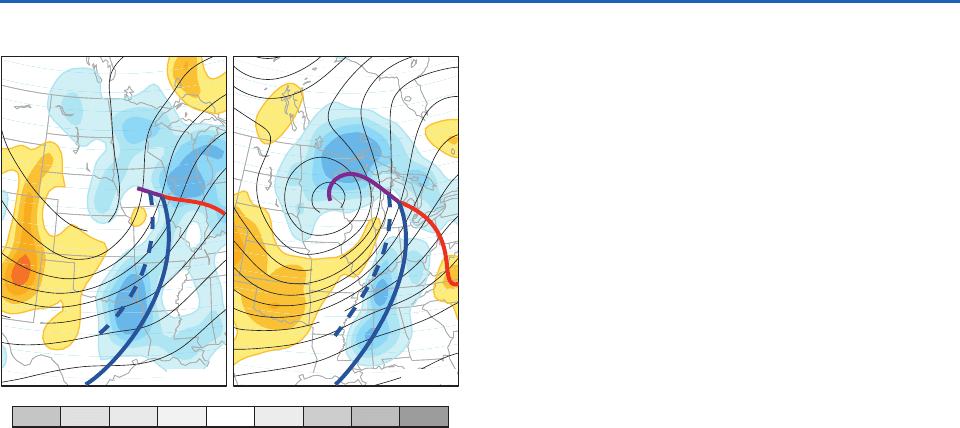
Figure 8.5 shows the vertical velocity field superim-
posed on the 500-hPa height field. In the left panel,
which corresponds to the time when the system is
developing most rapidly, the northward moving air
in the region of warm advection in advance of the
developing surface low is rising, while the southward
moving air in the region of cold advection to rear of
the cyclone is sinking. It is also apparent from the
right-hand panels of Fig. 8.3 that at any given latitude
the rising air to the east of the surface low is warmer
than the sinking air to the west of it. We recall from
Section 7.4.1 that the rising of warm air and sinking
of cold air is indicative of a conversion of potential
energy into kinetic energy. In the case of baroclinic
waves, the potential energy is associated with the
east–west temperature gradients and the kinetic
energy is primarily associated with the meridional
wind component.
Fig. 8.4 (Top) Fields of 500-hPa height (thick black contours) 1000-hPa height (thin black contours), and 1000- to 500-hPa
thickness (dashed red) at 00, 09, and 18 UTC Nov. 10, 1998; contour interval 60 m for all three fields. Arrows indicate the sense
of the geostrophic wind. (Bottom) Idealized depictions for a baroclinic wave and its attendant tropical extratropical cyclone in
its early (left), developing (center), and mature (right) stages. [Top panel courtesy of Jennifer Adams, COLAIGES. Bottom panel
adapted from Atmospheric Circulation Systems: Their Structure and Physical Interpretation, E. Palmén and C.W. Newton, p. 326,
Copyright (1969), with permission from Elsevier.]
P732951-Ch08.qxd 9/12/05 7:46 PM Page 317
318 Weather Systems
In the right-hand panel of Fig. 8.5 warmer air to
the east of the cyclone is still rising, but the region of
ascent wraps around the northern and western flanks
of the surface low. In a similar manner, the region of
subsidence to the west wraps around the southern
and eastern flanks of the cyclone. The juxtaposition
of these inward-spiraling rising and subsiding air cur-
rents, reminiscent of the “yin-yang pattern” in Asian
art, is influential in shaping the cloud and precipita-
tion patterns associated with extratropical cyclones,
as shown in the next subsection.
8.1.2 Fronts and Surface Weather
The previous subsection documented the broad out-
lines of an intense storm that developed over the
north central United States. Much of the significant
weather observed in association with such systems
tends to be concentrated within narrow bands called
frontal zones, which are marked by sharp horizontal
gradients and sometimes by outright discontinuities
in wind and temperature. The development of frontal
zones (frontogenesis, in the vernacular) is initiated
by the large-scale horizontal deformation field, as
discussed in Section 7.1.3. Mesoscale circulations in
the plane perpendicular to the fronts are instrumen-
tal in sharpening the temperature contrasts and in
organizing the distribution of precipitation into bands
oriented parallel to the fronts. This subsection docu-
ments the expressions of the November 10, 1998
storm and its attendant frontal zones in (a) wind
and pressure, (b) temperature, (c) moisture variables,
(d) surface weather, (e) the suite of hourly observa-
tions, (f) satellite imagery, and (g) radar imagery.
a. Wind and pressure
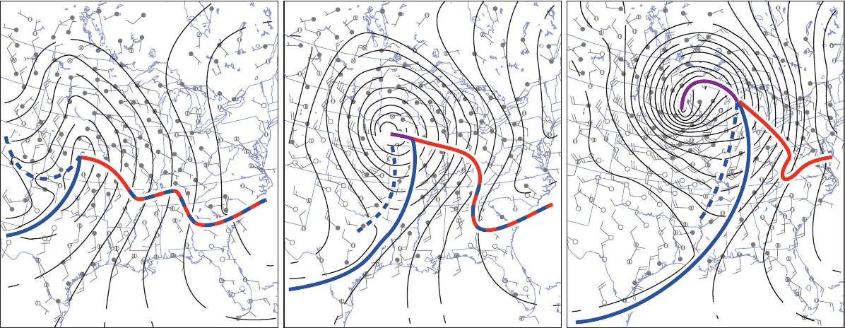
Figure 8.6 shows the sea-level pressure and surface
winds at 9-h intervals starting at 00 UTC Nov. 10
(note that the field of view is smaller than in the pre-
vious charts). At all three map times a pronounced
wind-shift line, the expression of the cold front in
the surface wind field, is evident to the south of the
surface low. To the west of the cold front the surface
winds exhibit a strong westerly component, whereas
to the east of it the southerly wind component is
dominant. The isobars bend sharply (and some
change direction abruptly or “kink”) along the front.
Hence, as the front passes, a fixed observer at the
Earth’s surface would experience a veering (i.e., shift-
ing in an anticyclonic sense) of the wind from
southerly to westerly, concurrent with a well-defined
minimum in sea-level pressure. Through the three-
chart sequence the cold front advances eastward,
keeping pace with and showing some tendency to
wrap around the surface low as it deepens and tracks
northeastward. It appears as though the front is being
advected by the intensifying cyclonic circulation.
The wind-shift line extending eastward from the sur-
face low, the expression of the warm front, is a more
subtle feature, the reality of which becomes clearly evi-
dent when the surface charts are analyzed in conjunc-
tion with hourly station data, as illustrated later in this
subsection. Like the cold front, the warm front shows
indications of being advected around the developing
surface low. When it passes a station the wind veers
from southeasterly to southerly. In the later stages of
the development of the cyclone, as represented in the
18 UTC panel in Fig. 8.6, the junction of the cold and
warm fronts becomes separated from the center of the
surface low and an occluded front extends from the
center of the surface low to a triple point where it
meets the junction of the warm and cold fronts. When
the occluded front passes a station the surface wind
veers from southeasterly to southwesterly.
A fourth wind-shift line, the expression of a
secondary cold front, rendered in dashed blue, also
appears on the charts for 00 and 09 UTC. In the 00
UTC chart the line curves eastward from the eastern
ω (Pa s
–1
)
–0.8 –0.6 –0.4 –0.2 0.2 0.4 0.6 0.8
540
540
570
570
522
L
L
09 UTC
18 UTC
Fig. 8.5 The 500-hPa height (in tens of meters) and vertical
velocity (in Pa s
1
) fields at the 700-hPa level at 09 and
18 UTC Nov. 10, 1998. Blue shading (negative
) indicates
ascent and tan shading indicates subsidence. [Courtesy of
Jennifer Adams, COLAIGES.]
P732951-Ch08.qxd 9/12/05 7:46 PM Page 318
L
L
L
00
00
04
08
08
12
16
16
20
08
08
08
00
92
84
80
12
12
16
20
16
16
12
08
04
96
88
80
72
16 20
24
24
20
16
24
24
Fig. 8.6 Sea-level pressure, surface winds and frontal positions at 00, 09, and 18 UTC 10 Nov. 1998. Frontal symbols and wind symbols are plotted in accor-
dance with Fig. 8.1. The dashed blue line denotes the secondary cold front. In this figure and in subsequent figures in this section, the frontal positions are defined
by a human analyst. The contour interval for sea-level pressure is 4 hPa. [Sea-level pressure and frontal analyses by Lynn McMurdie, figure Courtesy of Jennifer
Adams, COLA/IGES.]
P732951-Ch08.qxd 9/12/05 7:46 PM Page 319
320 Weather Systems
slope of the Colorado Rockies and then northeast-
ward into the center of the surface low. This feature
is also embedded in a trough in the sea-level pressure
field and causes the surface wind at a fixed station to
veer when it passes.
b. Temperature
Figure 8.7 shows the surface air temperatures at the
same three map times. The field is represented by
raw station data rather than by isotherms, and the
positions of the fronts are transcribed from the pre-
vious figure. In the southerly flow off the Gulf of
Mexico to the east of the cold front, temperatures
are relatively uniform, with values in excess of 20 °C
extending as far northward as southern Illinois at
09 UTC and values in the teens as far northward as
the Great Lakes at 18 UTC. This zone of relatively
uniform temperature to the southeast of the surface
low is referred to as the warm sector of a cyclone. The
cold front marks the leading edge of the advancing
colder air from the west. In this system, the cold front
is not a zero-order discontinuity in the temperature
field (i.e., a discontinuity of the temperature itself),
but a first-order discontinuity (i.e., a discontinuity in
the horizontal temperature gradient). To the east of
the cold front the temperatures are relatively homo-
geneous, while proceeding westward from the front,
temperatures drop by 10 °C or more within the first
few hundred kilometers. Hence, a cold front can be
defined as the warm-air boundary of a frontal zone
(or baroclinic zone) that is advancing in the direction
of the warmer air. The passage of a cold front at a
station marks the beginning of a period of falling
temperatures, heralded by a wind shift.
The November 10, 1998 storm had two cold fronts:
a primary cold front at the warm air boundary of
the frontal zone and a secondary cold front within
the frontal zone. The two cold fronts show up clearly
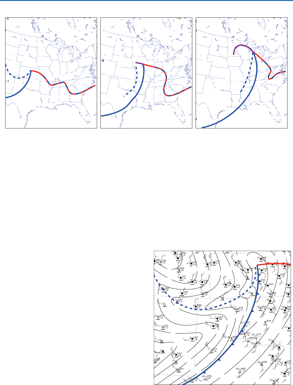
in the zoomed-in chart for 00 UTC, Nov. 10, 1998,
shown in Fig. 8.8. Both fronts are embedded within
19
13
–
2
–
2
–
2
–
2
–
2
–
2
–
2
–
2
–
2
–
2
–
2
– 2
–
2
–
2
–
2
–
2
–
2
–
2
–
2
–
2
–
2
–
6
–
6
–
3
–
3
–
3
–
8
–
3
–
3
– 3
–
3
–
2
–
3
–
2
–
3
–
1
–
1
–
1
–
1
–
1
–
1
–
1
–
1
–
1
–
12
–
1
–
1
–
2
–
2
–
2
–
3
–
4
–
4– 4
–
4
–
4
–
4
–
4
–
4
–
4
–
4
–
4
0
6
6
6
6
6
3
3
0
0
0
9
16
7
7
2
2
2
5
3
4
8
18
18
19
19
19
19
20
16
13
10
12
14
13
11
20
21
23
23
23
23
23
19
13
13
13
12
13
13
11
10
10
11
1
4
4
6
5
5
8
4
1
2
2
2
2
2
22
22
22
22
24
24
19
17
14
14
15
15
17
7
7
8
9
9
9
1
1
15
16
22
21
21
23
–
4
–
4
–
6
–
6
–
6
–
6
–
6
–
8
–
8
–
8
– 8
–
8
–
7
–
1
–
1
–
1
1
1
1
–
1
–
1
–
7
–
7
–
3
–
5
–
5
–
5
–
5
–
9
–
3
3
–
5
–
1
–
1
–
1
–
1
–
1
–
1
–
1
–
1
–
1
–
1
–
1
–
2
–
4
–
4
–
4
–
4
–
4
–
4
–
4
–
6
–
6
–
3
–
3
3
3
7
7
1
1
0
–
3
–
3
– 3
–
7
–
1
2
12
13
13
19
15
16
11
11
7
5
9
23
24
24
22
22
22
25
25
25
22
22
24
22
21
21
21
10
13
17
17
1
7
7
7
7
7
5
8
8
8
8
8
6
6
6
6
6
6
9
4
5
5
4
4
1
1
1
1
1
1
1
10
0
0
0
0
0
0
0
0
0
4
4
4
2
2
2
2
6
6
6
6
5
6
3
3
3
13
14
13
13
11
11
11
12
12
20
20
19
19
18
18
21
24
23 23
23
23
23
23
–
1
– 3
– 3
–
3
–
6
–
5
–
7
–
3
–
5
0
0
0
0
0
0
0
0
1
1
1
7
7
7
7
7
7
8
4
10
7
7
7
7
2
2
3
3
2
2
2
1
1
0
3
8
8
8
15
5
6
14
13
11
12
11
11
11
11
11
12
12
13
13
13
14
14
14
21
21
24
24
23
26
26
22
21
28
28
28
26
27
25
26
26
22
21
22
20
19
19
10
17
15
7
4
4
4
1
12
8
20
21
27
29
28
28
20
15
15
15
19
19
16
18
18
18
16
18
16
16
17
15
16
8
9
4
6
6
1
3
3
3
3
3
22
24
22
Fig. 8.7 Surface air temperature (in °C) and frontal positions at 00, 09, and 18 UTC 10 Nov. 1998. [Courtesy of Jennifer
Adams, COLAIGES.]
L
06
04
02
00
00
00
98
98
04
02
02
08
06
04
04
98
02
00
98
00
02
04
02
00
98
98
96
96
96
94
94
96
Fig. 8.8 Close-up of surface weather conditions over the
southern United States Great Plains at 00 UTC Nov. 10,
1998, showing data plotted using the conventional station
model illustrated in Fig. 8.1. [Courtesy of Lynn McMurdie.]
P732951-Ch08.qxd 9/12/05 7:46 PM Page 320

8.1 Extratropical Cyclones 321
troughs of low pressure and their passage is marked
by wind shifts. The passage of the primary cold front
marks the onset of the cooling and the passage of the
secondary front marks the beginning of an interval
of renewed cooling. The secondary cold front marks
the leading edge of a band of enhanced baroclinicity
(i.e., temperature gradient) within the more broadly
defined frontal zone. The passage of such a front
marks the onset of renewed cooling.
The more subtle warm front in Fig. 8.7 also marks the
warm-air boundary of a baroclinic zone, but in this case
the baroclinic zone is advancing northward, displacing
the colder air. The passage of a warm front at a fixed
station thus is preceded by an interval of rising tem-
peratures. Fronts that exhibit little movement in either
direction are labeled as stationary fronts and are indi-
cated on synoptic charts as dashed lines with alternat-
ing red and blue line segments, as in Figs. 8.6 and 8.7.
From an inspection of Fig. 8.4 it is evident that
in the early stages of cyclone development, the cold
and warm fronts mark the warm air boundary of
the same, continuous baroclinic zone. The cyclone
develops along the warm air boundary of the frontal
zone, but it subsequently moves away from it, in the
direction of the colder air. As this transition occurs,
air from within the frontal zone wraps around the
cyclone forming the occluded front. It is apparent
from Fig. 8.7 that as the occluded front, rendered in
purple, approaches a station, surface air temperature
rises, and after the front passes the station, the tem-
perature drops. From the standpoint of a stationary
observer, experiencing the passage of an occluded
front is like experiencing the passage of back-to-
back warm and cold fronts except that the temper-
ature changes are usually more subtle because the
observer does not experience temperatures as high
as those in the warm sector.
Fronts on surface maps are expressions of frontal
surfaces that extend upward to a height of several kilo-
meters, sloping backward toward the colder air.
Regardless which way the front is moving, air converges
toward the front at low levels and the warmer air tends
to be lifted up and over the frontal surface along slop-
ing trajectories, as depicted in Fig. 8.9. In the case of a
stationary front, warm air may be advancing aloft while
the frontal zone air trapped beneath the frontal surface
remains stationary. In the case of a cold front, the wind
component normal to the front may be in the opposite
direction below and above the frontal surface.
Fronts are sometimes pictured as material surfaces,
separating air masses characterized by different tem-
peratures andor humidities, that move about pas-
sively in the atmosphere, advected by the winds.
This simplistic description ignores the important role
of dynamical processes in forming and maintaining
fronts. The formation of fronts, a process referred to as
frontogenesis, involves two-steps. In the first step, the
broad, diffuse equator-to-pole temperature gradient
tends to be concentrated into frontal zones hundreds
of kilometers in width by the large-scale deformation
field, as discussed in Section 7.1.3. In the second step,
transverse circulations, like those depicted in Fig. 8.9,
collapse the low-level temperature gradients within
preexisting, still relatively broad frontal zones, down
to a scale of tens of kilometers or less.
Lest the role of fronts in mediating surface air
temperature be overemphasized, it should be noted
that other factors such as time of day, sky cover,
altitude of the station, and proximity to large bodies
of water can, at times, exert an equally important
influence on the temperature pattern. In fact, it is
sometimes difficult to locate fronts on the basis of
gradients of surface air temperature because
• Over the oceans, surface air temperature is
strongly influenced by the temperature of the
underlying water, especially in regions where the
atmospheric boundary layer is stably stratified.
• In mountainous terrain, large differences in
station elevation mask the temperature gradients
on horizontal surfaces.
• Unresolved features such as terrain effects, patchy
nocturnal inversions, convective storms, and
urban heat island effects can raise or lower the
temperature at a given station by several degrees
relative to that at neighboring stations.Apparent
temperature discontinuities associated with these
features are sometimes misinterpreted as fronts.
Warm front Stationary front Cold front
Fig. 8.9 Idealized cross sections through frontal zones show-
ing air motions relative to the ground in the plane transverse to
the front. Colored shading indicates the departure of the local
temperature from the mean temperature of the air at the same
level. (a) Warm front, (b) stationary front with overrunning
warm air, and (c) cold front. Heavy arrows at the bottom indi-
cate the sense of the frontal movements.
P732951-Ch08.qxd 9/12/05 7:46 PM Page 321

322 Weather Systems
c. Moisture
Frontal zones also tend to be marked by strong gradi-
ents in dew point and equivalent potential tempera-
ture, especially when the cold air is of continental origin
and the warmer air is of marine origin, as is often the
case over the eastern United States. In the case study
considered in this section, the distributions of tempera-
ture and dew point are generally similar. However, dur-
ing spring and summer, the moisture gradient is often a
more reliable indicator of frontal positions than the
gradient of surface air temperature because it is less
subject to the confounding influence of diurnal vari-
ability. For example, during summer over land, the diur-
nal temperature range at the ground tends to be larger
in cool, dry continental air masses than in warm, humid
air from off the Gulf of Mexico. Thus, during afternoon
it is not uncommon for surface temperatures well
behind the cold front to be as high as those on the
warm sector of the cyclone, even though there is con-
siderable thermal contrast 1–2 km above the ground. In
such situations, the front is more clearly defined in the
dew point field than in the temperature field.
Land–sea geometry and terrain features can some-
times give rise to fronts in the moisture field that
have no direct relation to extratropical cyclones.
For example, during summer, under conditions of
southerly low level flow, there often exists a sharp
contrast between humid air advected northward
from the Gulf of Mexico and much drier air that
has subsided along the eastern slopes of the Rockies.
The boundary between these marine and continental
air masses is referred to as the dry line.
d. Hourly observations
Now let us look at the expressions of fronts in hourly
surface observations. Hourly pressure, surface wind,
temperature, and dew point observations for Gage,
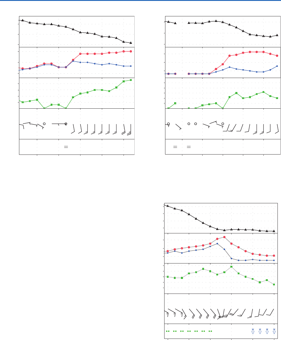
Oklahoma, shown in Fig. 8.10, confirm the passage of
the primary cold front at 22 UTC (16 LT) Nov. 9, as
evidenced by the strong veering of the wind and the
onset of an interval of falling temperature and rising
sea-level pressure. The passage of the secondary cold
front occurred around 03 UTC Nov. 10, when the
wind veered and strengthened, the sea-level pressure
exhibited a weak minimum, and temperature and
dew point began to drop more sharply after having
nearly leveled off for several hours.
The time series for Bowling Green, Kentucky,
shown in Fig. 8.11, are indicative of a well-defined
warm frontal passage around 05 UTC (23 LT), with a
wind shift from easterly to southerly and a leveling
off of the dew point after a prolonged rise. Surface air
temperature leveled off an hour later. Pressure con-
tinued to drop due to the approach and deepening of
the surface low, but the rate of change was smaller
than it had been prior to the passage of the front.
As the storm moved northeastward the band of
strongest baroclinicity (i.e., horizontal temperature
gradient) shifted northward into the Great Lakes and
the warm front became less distinct. To the east of
the Appalachian mountain range the advance of the
warm air was delayed by a persistent, topographically
induced easterly flow, evident at several of the sta-
tions in Fig. 8.6, which advected cooler air southward
through the Carolinas and Georgia. By 18 UTC
(Fig. 8.6 right panel) the intensifying southerly winds
in advance of the approaching cold front scoured out
this colder air, resulting in an abrupt northward shift
of the warm front at the Earth’s surface. Time series
of surface variables at Columbia, South Carolina, on
the eastern side of the Appalachians (Fig. 8.12) show
the warm frontal passage around 16 UTC (11 LT),
which was marked by a wind shift and a rapid rise in
temperature and dew point. On the west side of the
06 UTC0300
10 Nov.
2118
9 Nov.
Wind speed (kt) Temperature (°C) Pressure (hPa)
Dew point (°C)
1008
1004
1000
996
992
20
15
10
5
0
25
20
15
5
10
Fig. 8.10 Hourly surface observations at Gage, Oklahoma
(KGAG in Fig. 8.36) showing the passage of the primary and
secondary cold fronts. The locations of Gage and the other
stations for which time series of hourly station observations
are shown are indicated in Fig. 8.36 at the end of Section 8.2.
[Courtesy of Jennifer Adams, COLAIGES.]
P732951-Ch08.qxd 9/12/05 7:46 PM Page 322
8.1 Extratropical Cyclones 323
Appalachians the northward advance of the warm air
occurred 12–18 h earlier.
The time series for Marquette, Michigan (Fig. 8.13)
provides an example of the passage of an occluded
front. The frontal passage, which occurred around
20 UTC Nov. 20 was attended by a leveling off of
the pressure after reaching a remarkably low value
of 975 hPa, an abrupt transition from rising to falling
temperatures, and a more gradual veering of the
wind, from southeasterly to southwesterly. Precipita-
tion ended 3 h before the passage of the front and
resumed, in the form of snow showers, 3 h after the
frontal passage.
The movement and deepening of the surface low
and the advance of the fronts are clearly evident
in charts of the 3-h pressure tendency. The example
shown in Fig. 8.14 is for the 3-h ending 09 UTC
Nov. 10, the time of the middle chart in Figs. 8.6
and 8.7. The falling pressure centered over Iowa
reflects both the approach and the deepening of
the surface low. The pressure rises behind the
cold front reflect the higher density of the colder air
that was advancing into territory that was formerly a
part of the warm sector of the cyclone. The pressure
was falling rapidly ahead of the occluded front,
while the pressure was steady behind it, the rising
tendency induced by low level cold advection nearly
12 UTC09060300
10 Nov.
Wind speed (kt) Temperature (°C) Pressure (hPa)
Dew point (°C)
1016
1012
1008
20
15
10
20
15
5
10
Fig. 8.11 Hourly surface observations at Bowling Green,
Kentucky (KBWG in Fig. 8.36) showing the passage of the
warm front. [Courtesy of Jennifer Adams, COLAIGES.]
21 UTC18151209
10 Nov.
Wind speed (kt) Temperature (°C) Pressure (hPa)
Dew point (°C)
1024
1020
1016
25
20
15
25
20
15
10
5
Fig. 8.12 Hourly surface observations at Columbia, South
Carolina (KCAE in Fig. 8.36) showing the delayed passage of
the warm front. [Courtesy of Jennifer Adams, COLAIGES.]
03 UTC2118
10 Nov.
1512
10 Nov.
00
11 Nov.
Wind speed (kt) Temperature (°C) Pressure (hPa)
Dew point (°C)
1000
992
984
976
10
5
0
25
20
15
5
10
Fig. 8.13 Hourly surface observations at Marquette, Michigan
(KMQT in Fig. 8.36) showing the passage of the occluded front.
[Courtesy of Jennifer Adams, COLAIGES.]
balanced by the falling tendency induced by the
deepening of the low as it passed to the northwest of
the station.
P732951-Ch08.qxd 9/12/05 7:46 PM Page 323
