Saltzman B. (editor) Anomalous Atmospheric Flows and Blocking
Подождите немного. Документ загружается.

384
CARLOS R. MECHOSO
ET
AL.
DAYS
6-10
DAYS
6-10
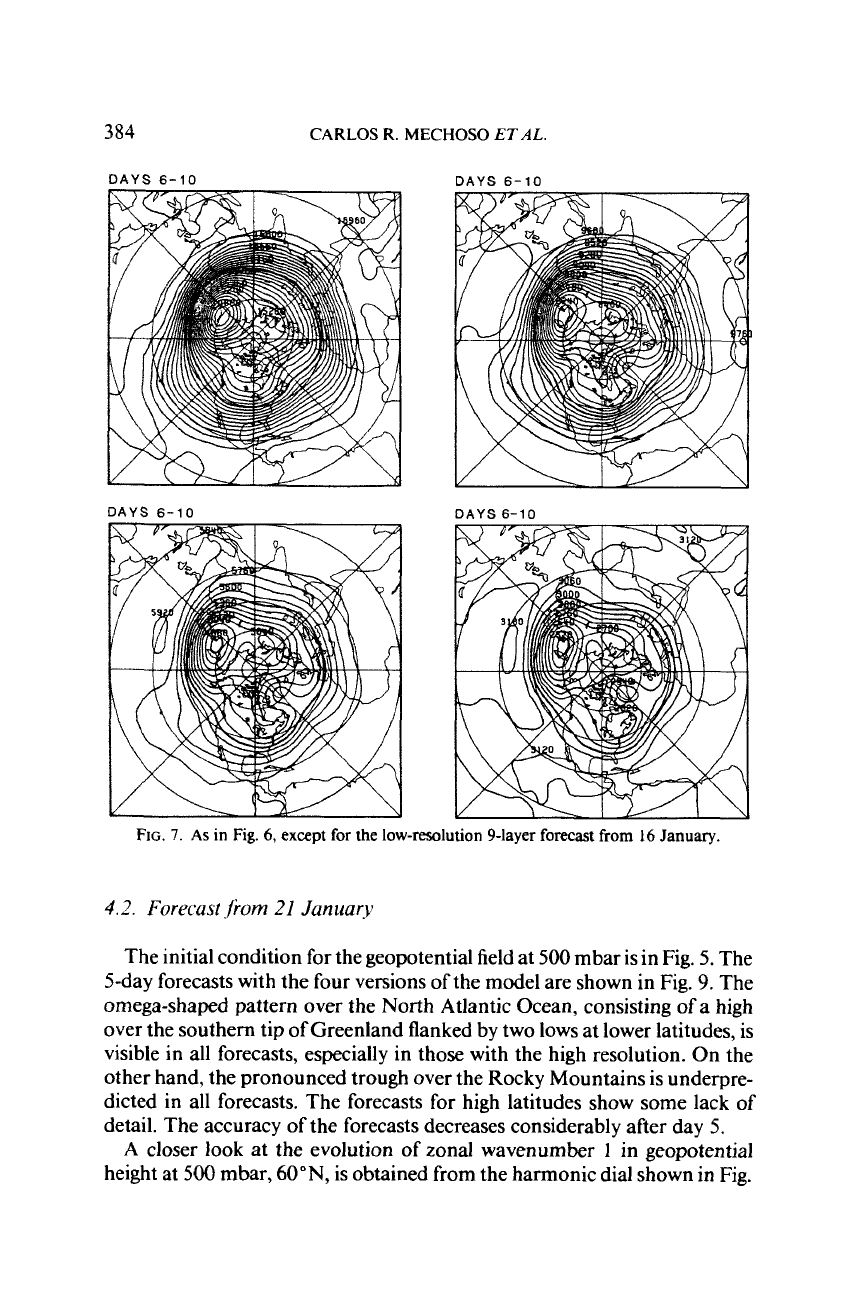
FIG.
7.
As
in
Fig.
6,
except
for
the
low-resolution 9-layer forecast from
16
January.
4.2.
Forecast
Jrom
21
January
The initial condition for the geopotential field at
500
mbar is in Fig.
5.
The
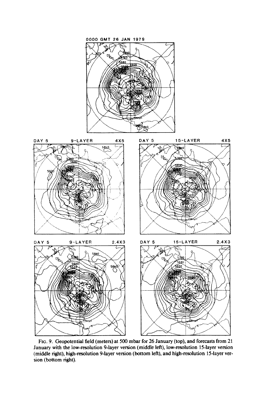
5-day forecasts with the four versions of the model are shown in Fig.
9.
The
omega-shaped pattern over the North Atlantic Ocean, consisting of a high
over the southern tip of Greenland flanked by two lows at lower latitudes, is
visible in all forecasts, especially in those with the high resolution. On the
other hand, the pronounced trough over the Rocky Mountains is underpre-
dieted
in
all forecasts. The forecasts for high latitudes show some lack of
detail. The accuracy
of
the forecasts decreases considerably after day
5.
A
closer
look
at
the evolution
of
zonal wavenumber
1
in geopotential
height at
500
mbar,
60"N,
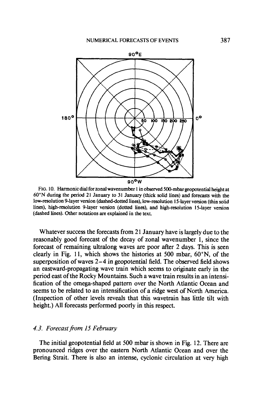
is obtained from the harmonic dial shown in Fig.
DAYS
6-10
NUMERICAL FORECASTS OF EVENTS
385
DAYS
6-10
DAYS
6-10
DAYS
6-10
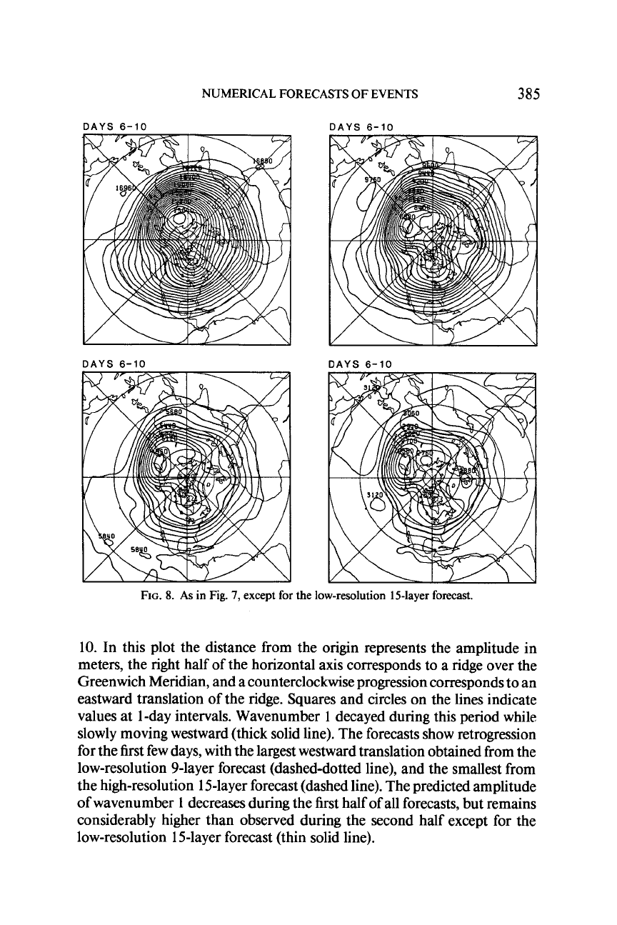
FIG.
8.
As in Fig.
7,
except for the low-resolution 15-layer forecast.
10. In this plot the distance from the origin represents the amplitude in
meters, the right half of the horizontal axis corresponds to a ridge over the
Greenwich Meridian, and a counterclockwise progression corresponds to an
eastward translation of the ridge. Squares and circles on the lines indicate
values at
1
-day intervals. Wavenumber
1
decayed during this period while
slowly moving westward (thick solid line). The forecasts show retrogression
for the first few days, with the largest westward translation obtained from the
low-resolution 9-layer forecast (dashed-dotted line), and the smallest from
the high-resolution
1
5-layer forecast (dashed line). The predicted amplitude
of wavenumber
1
decreases during the first half of all forecasts, but remains
considerably higher than observed during the second half except for the
low-resolution
1
5-layer forecast (thin solid line).
DAY
5
9-LAYER
4x5
DAY
5
15-LAYER
4x5
DAY 5 9-LAYER
2.4X3
DAY
5
15-LAYER
2.4X3
FIG.
9. Geopotential field (meters) at 500 mbar
for
26
January (top), and
forecasts
from
21
January with the low-resolution 9-layer version (middle left), low-resolution 15-layer version
(middle right), high-resolution 9-layer version (bottom left), and high-resolution 15-layer ver-
sion
(bottom right).
NUMERICAL FORECASTS OF EVENTS
387
QOOE
180'
QOOW
FIG.
10.
Harmonic dial for zonal wavenumber
1
in
observed
500-mbar popotential
height at
60"N
during the period
21
January to
31
January (thick solid lines) and forecasts with the
low-resolution 9-layer version (dasheddotted lines), low-resolution 15-layer version (thin solid
lines), high-resolution 9-layer version (dotted lines), and high-resolution 15-layer version
(dashed lines). Other notations
are
explained in the text.
Whatever success the forecasts from
2
1
January have is largely due to the
reasonably good forecast of the decay of zonal wavenumber
1,
since the
forecast of remaining ultralong waves are poor after
2
days. This is seen
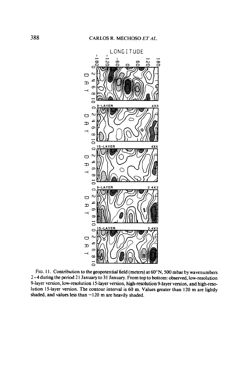
clearly in Fig.
11,
which shows the histories at
500
mbar, 60"N, of the
superposition of waves
2-4
in geopotential field. The observed field shows
an eastward-propagating wave train which seems to originate early in the
period east of the Rocky Mountains. Such a wave train results in an intensi-
fication of the omega-shaped pattern over the North Atlantic Ocean and
seems to
be
related to an intensification of a ridge west
of
North America.
(Inspection of other levels reveals that this wavetrain has little tilt with
height.) All forecasts performed poorly in this respect.
4.3.
Forecast
fiom
If
February
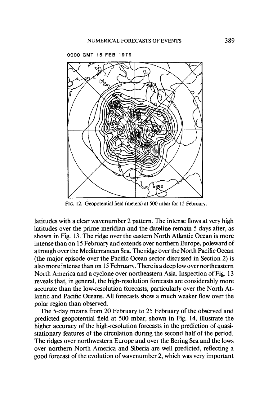
The initial geopotential field at
500
mbar is shown in Fig.
12.
There are
pronounced ridges over the eastern North Atlantic Ocean and over the
Bering Strait. There is also an intense, cyclonic circulation at very high
388
CARLOS
R.
MECHOSO
ETAL
LONG
I
TUDE
I1
-*I
*-
ODnJQ)
m'vw
oo
0
0
0
0
0
0
ow
c
m
D
4
a
-
0
0
o'v
DG
m
+
OD
0
0
L
ow
c
0
OD
0
0
D
*
-
o'v
,I=
m
OD
D
-(
-
FIG.
1 1.
Contribution to the geopotential field (meters) at
60"N.
500
mbar by wavenumbers
2
-4
during the
period
2
I
January
to
3
1
January. From top to bottom: observed, low-resolution
9-layer version, low-resolution 15-layer version, high-resolution 9-layer version, and high-reso-
lution 15-layer version. The contour interval is
60
m.
Values
greater than
120
m are lightly
shaded, and values less than
-120
m
are
heady shaded.
NUMERICAL FORECASTS OF EVENTS
389
0000
GMT
15
FEB
1979
FIG.
12.
Geopotential field (meters) at
500
mbar
for
15
February.
latitudes with a clear wavenumber
2
pattern. The intense flows at very high
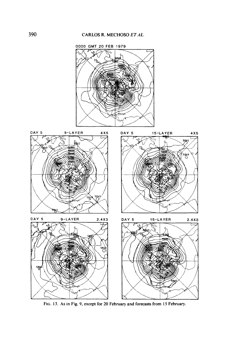
latitudes over the prime meridian and the dateline remain
5
days after, as
shown in Fig. 13. The ridge over the eastern North Atlantic Ocean is more
intense than on 15 February and extends over northern Europe, poleward of
a trough over the Mediterranean Sea. The ridge over the North Pacific Ocean
(the major episode over the Pacific Ocean sector discussed in Section
2)
is
also more intense than on 15 February. There is a deep low over northeastern
North America and a cyclone over northeastern Asia. Inspection of Fig. 13
reveals that, in general, the high-resolution forecasts are considerably more
accurate than the low-resolution forecasts, particularly over the North At-
lantic and Pacific Oceans. All forecasts show a much weaker flow over the
polar region than observed.
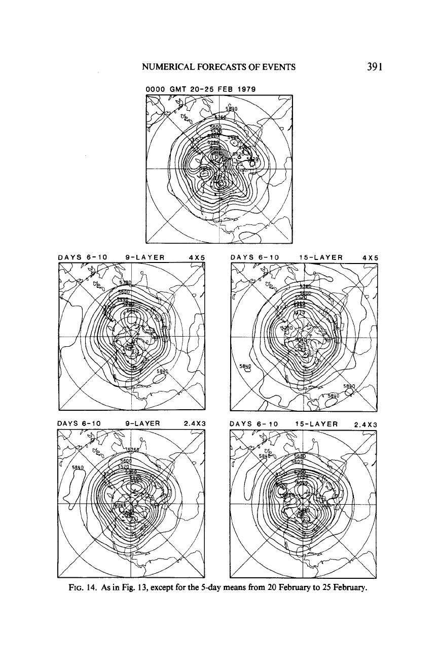
The 5-day means from 20 February to
25
February of the observed and
predicted geopotential field at
500
mbar, shown in Fig. 14, illustrate the
higher accuracy of the high-resolution forecasts in the prediction of quasi-
stationary features of the circulation during the second half of the period.
The ridges over northwestern Europe and over the Bering Sea and the lows
over northern North America and Siberia are well predicted, reflecting a
good forecast of the evolution of wavenumber
2,
which was very important
390
CARLOS R. MECHOSO
ET
AL
0000
GMT
20
FEB
1979
DAY
5
15-LAYER
4x5
DAY
5
9-LAYER
2.4X3
DAY
5
15-LAYER
2.4X3
FIG.
13.
As
in
Fig.
9,
except
for
20
February and
forecasts
from
I5
February.
NUMERICAL FORECASTS OF EVENTS
0000
GMT
20-25
FEB 1979
39
1
DAYS 6-10 9-LAYER
4x5
DAYS 6-10 15-LAYER
4X
DAYS 6-10 9-LAYER
2.4X3
DAYS
6-10
15-LAYER
2.4X3
FIG.
14.
As in Fig.
13,
except
for
the
5-day
means
from
20
February
to
25
February.
392
CARLOS
R.
MECHOSO
ET
AL
OOOOGMT
17
FEB
1979
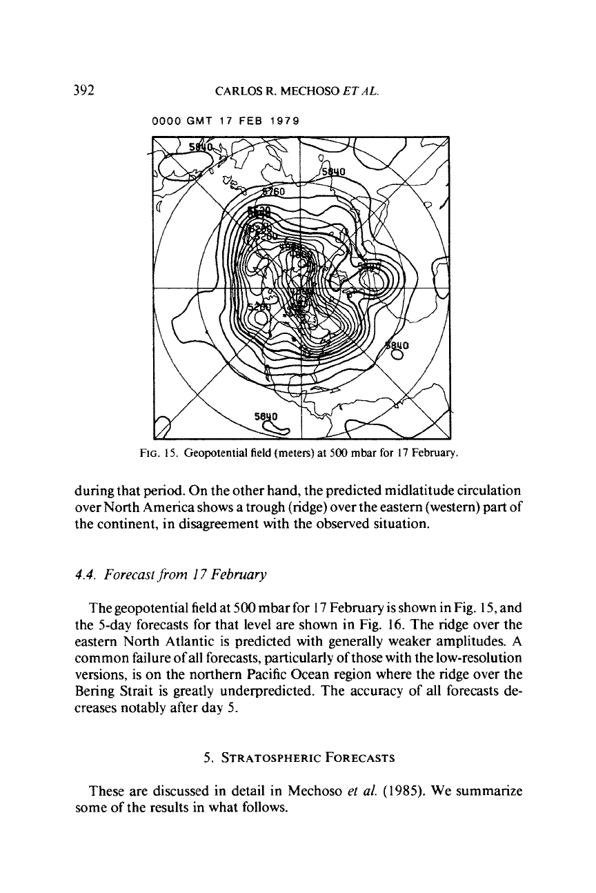
FIG.
IS.
Geopotential field (meters) at
500
mbar for
17
February.
during that period. On the other hand, the predicted midlatitude circulation
over North America shows a trough (ridge) over the eastern (western) part of
the continent, in disagreement with the observed situation.
4.4.
Forecast
jrom
I7
February
The geopotential field at
500
mbar for
17
February is shown in Fig.
15,
and
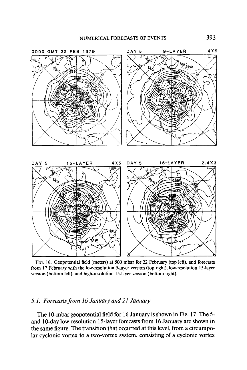
the 5-day forecasts for that level are shown in Fig.
16.
The ridge over the
eastern North Atlantic is predicted with generally weaker amplitudes.
A
common failure
of
all forecasts, particularly of those with the low-resolution
versions, is on the northern Pacific Ocean region where the ridge over the
Bering Strait is greatly underpredicted. The accuracy of all forecasts de-
creases notably after day
5.
5.
STRATOSPHERIC FORECASTS
These are discussed in detail in Mechoso
et al.
(1985).
We summarize
some of the results in what follows.
NUMERICAL FORECASTS
OF
EVENTS
393
0000
GMT
22 FEB
1979
DAY 5 9-LAYER 4x5
DAY
5
15-LAYER 4x5
FIG.
16.
Geopotential field (meters) at 500 mbar for
22
February (top left), and forecasts
from
17
February with the low-resolution 9-layer version (top
right),
low-resolution 15-layer
version (bottom left), and high-resolution 15-layer version (bottom right).
5.1.
Forecastsfrom
16
January and
21
January
The
1
0-mbar geopotential field for 16 January is shown in Fig.
17.
The 5-
and 10-day low-resolution 15-layer forecasts from 16 January are shown in
the same figure. The transition that occurred at this level, from a circumpo-
lar cyclonic vortex to a two-vortex system, consisting of a cyclonic vortex
