Saltzman B. (editor) Anomalous Atmospheric Flows and Blocking
Подождите немного. Документ загружается.

394
CARLOS
R.
MECHOSO
ET
AL.
0000
GMT
21
JAN
1979
0000
GMT
26
JAN
1979
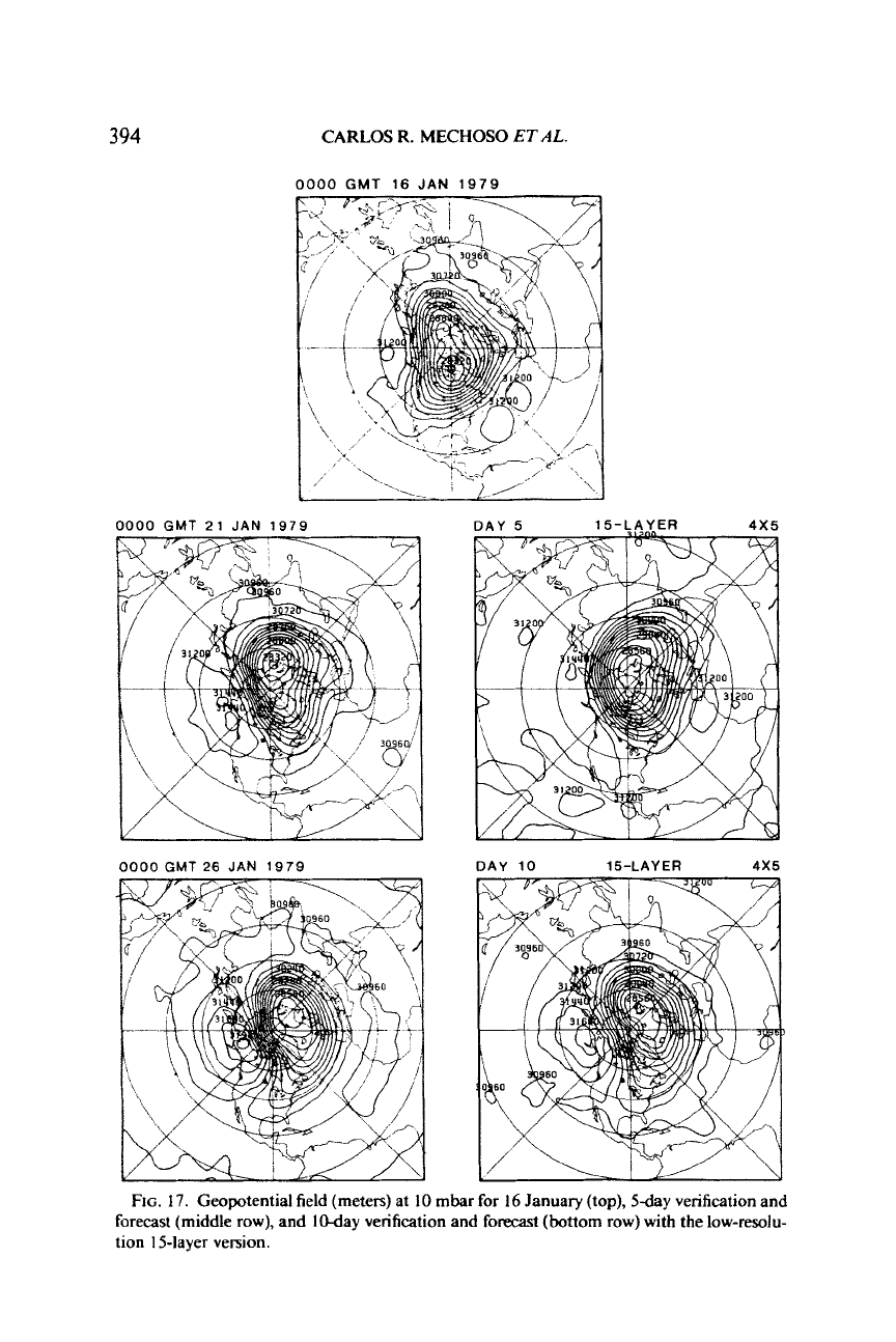
FIG.
17.
Geopotential field (meters) at
10
mbar
for
16
January (top), 5day verification and
forecast (middle
row),
and I0-day verification and
forecast
(bottom row) with the low-resolu-
tion 15-layer version.
NUMERICAL FORECASTS OF EVENTS
395
2.4X3
0
2
4
6
810
DAY
DAY
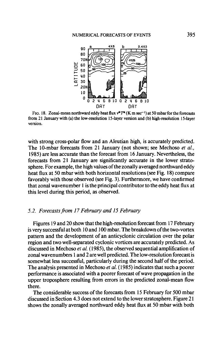
FIG.
18.
Zonal-mean northward eddy heat
flux
v*T*
(K
m
sec-')
at
50
mbar for the forecasts
from 21 January with (a) the low-resolution 15-layer version and (b) high-resolution 15-layer
version.
with strong cross-polar flow and an Aleutian high, is accurately predicted.
The 10-mbar forecasts from 21 January (not shown; see Mechoso
et al.,
1985)
are less accurate than the forecast from 16 January. Nevertheless, the
forecasts from
21
January are significantly accurate in the lower strato-
sphere. For example, the high values of the zonally averaged northward eddy
heat flux at
50
mbar with both horizontal resolutions
(see
Fig.
18)
compare
favorably with those observed (see Fig.
3).
Furthermore, we have confirmed
that zonal wavenumber
1
is
the principal contributor to the eddy heat flux at
this level during this period, as observed.
5.2.
Forecastsfrom
17
February and
15
February
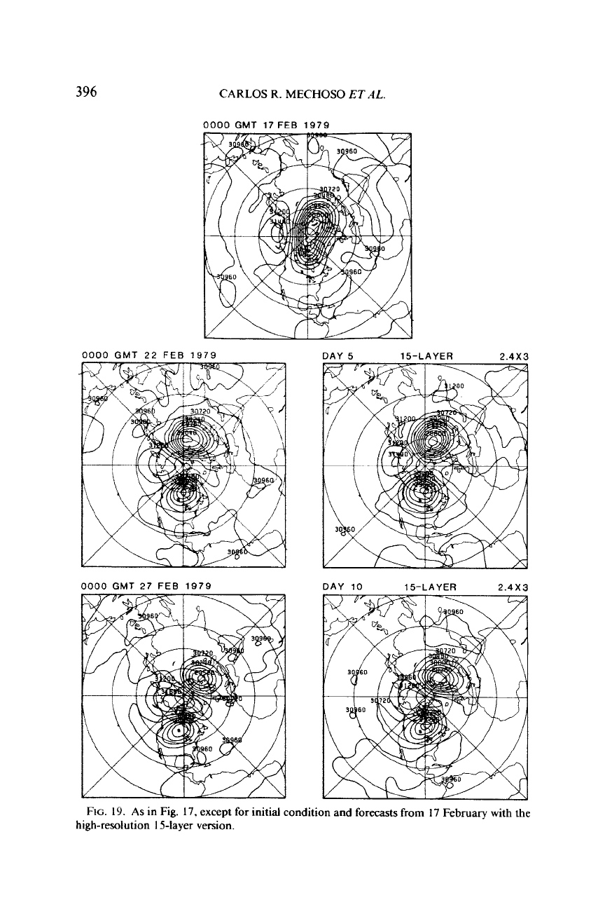
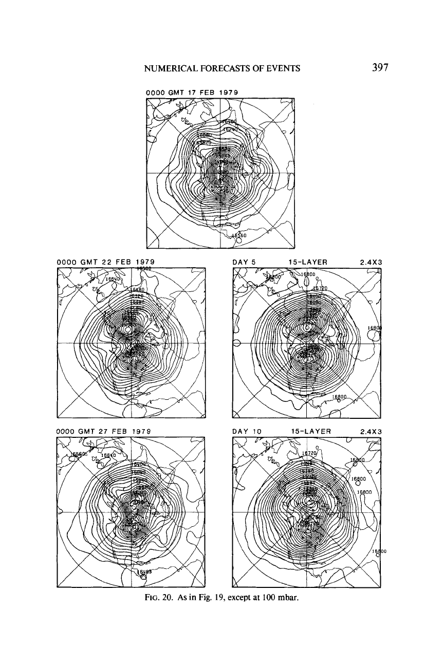
Figures 19 and
20
show that the high-resolution forecast from 17 February
is very successful at both
10
and
100
mbar. The breakdown ofthe two-vortex
pattern and the development of an anticyclonic circulation over the polar
region and two well-separated cyclonic vortices are accurately predicted.
As
discussed in Mechoso
et al.
(1985),
the observed sequential amplification of
zonal wavenumbers
1
and 2 are well predicted. The low-resolution forecast is
somewhat less successful, particularly during the second half of the period.
The analysis presented in Mechoso
et al.
(1 985) indicates that such a poorer
performance is associated with a poorer forecast
of
wave propagation in the
upper troposphere resulting from errors in the predicted zonal-mean
flow
there.
The considerable success of the forecasts from 15 February for
500
mbar
discussed in Section
4.3
does not extend to the lower stratosphere. Figure
2
1
shows the zonally averaged northward eddy heat flux at
50
mbar with both
396
CARLOS R.
MECHOSO
ET
AL.
0000
GMT
22
FEE
1979
0000
GMT
27
FEB 1979
DAY 10 15-LAYER
2.4X3
FIG.
19.
As
in Fig.
17,
except
for
initial condition and
forecasts
from
17
February with
the
high-resolution
1
Slayer version.
NUMERICAL FORECASTS OF EVENTS
0000
GMT
17
FEB
1979
397
0000
GMT
22
FEB 1979
DAY
5
15-LAYER
2.4X3
FIG.
20.
As in Fig.
19,
except
at
100
mbar.
398
CARLOS
R.
MECHOSO
ET
AL.
4x5
b
2.4X3
'0
2
rl
6
8100
2
U
6
810
DRY
DRY
FIG.
2
I.
As
in
Fig.
18,
except
for
the
forecasts
from
I5
February.
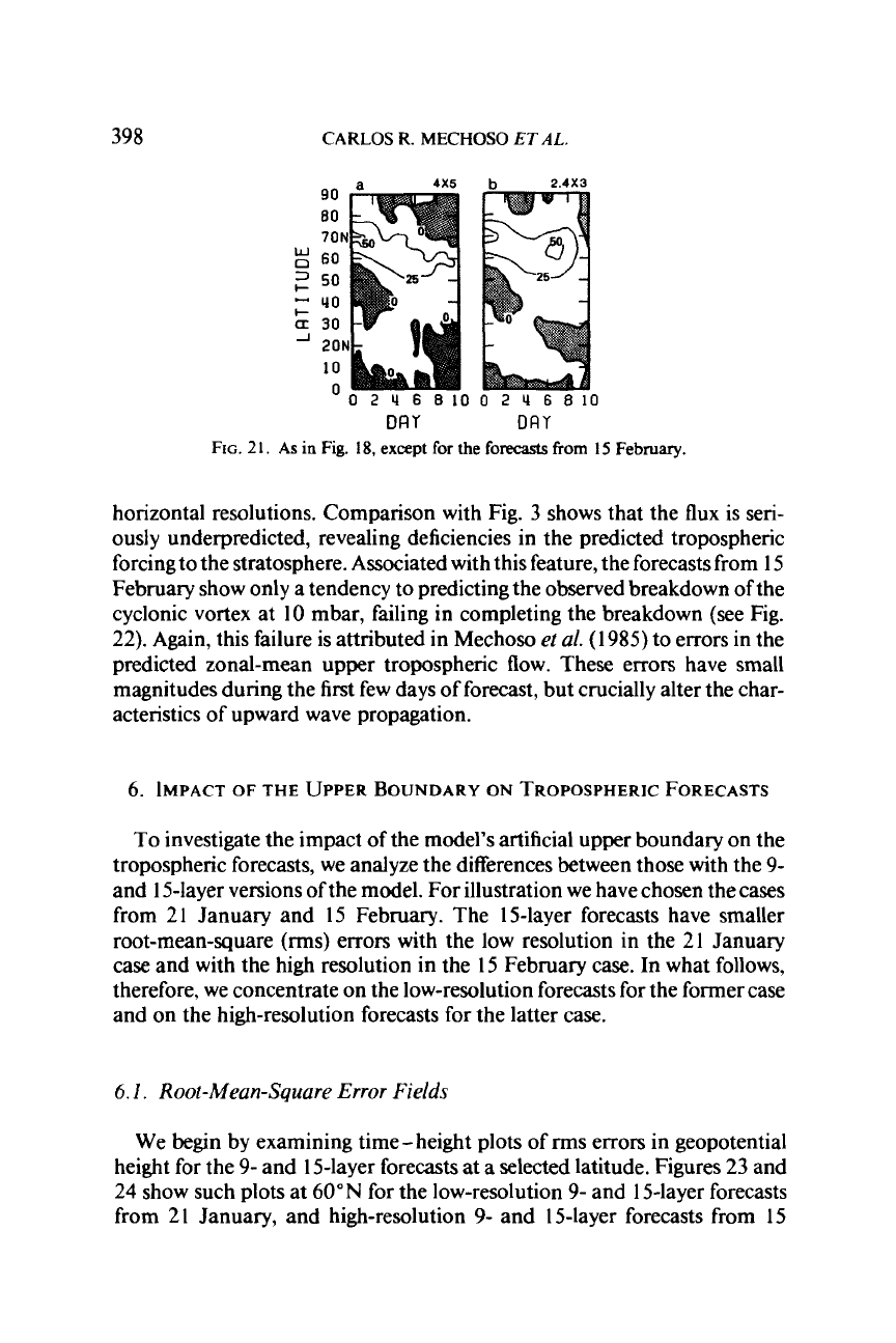
horizontal resolutions. Comparison with Fig.
3
shows that the flux is seri-
ously underpredicted, revealing deficiencies in the predicted tropospheric
forcing to the stratosphere. Associated with this feature, the forecasts from
15
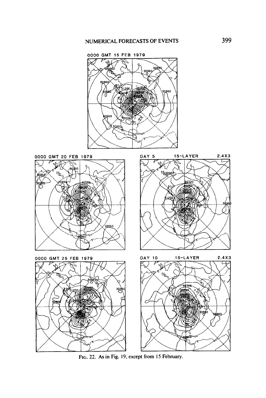
February show only a tendency to predicting the observed breakdown of the
cyclonic vortex at 10 mbar, failing
in
completing the breakdown (see Fig.
22). Again, this failure is attributed in Mechoso
ez
a!.
(1
985)
to errors in the
predicted zonal-mean upper tropospheric flow. These errors have small
magnitudes during the first few days of forecast, but crucially alter the char-
acteristics of upward wave propagation.
6.
IMPACT
OF
THE UPPER
BOUNDARY
ON
TROPOSPHERIC
FORECASTS
To
investigate the impact of the model's artificial upper boundary on the
tropospheric forecasts, we analyze the differences between those with the
9-
and
1
5-layer versions of the model. For illustration we have chosen the cases
from 21 January and 15 February. The 15-layer forecasts have smaller
root-mean-square
(rms)
errors with the low resolution in the 21 January
case and with the high resolution in the
I5
February case. In what follows,
therefore, we concentrate on the low-resolution forecasts for the former case
and on the high-resolution forecasts for the latter case.
6.
I.
Root-Mean-Square Error Fields
We begin by examining time-height plots of
rms
errors in geopotential
height for the
9-
and 15-layer forecasts at
a
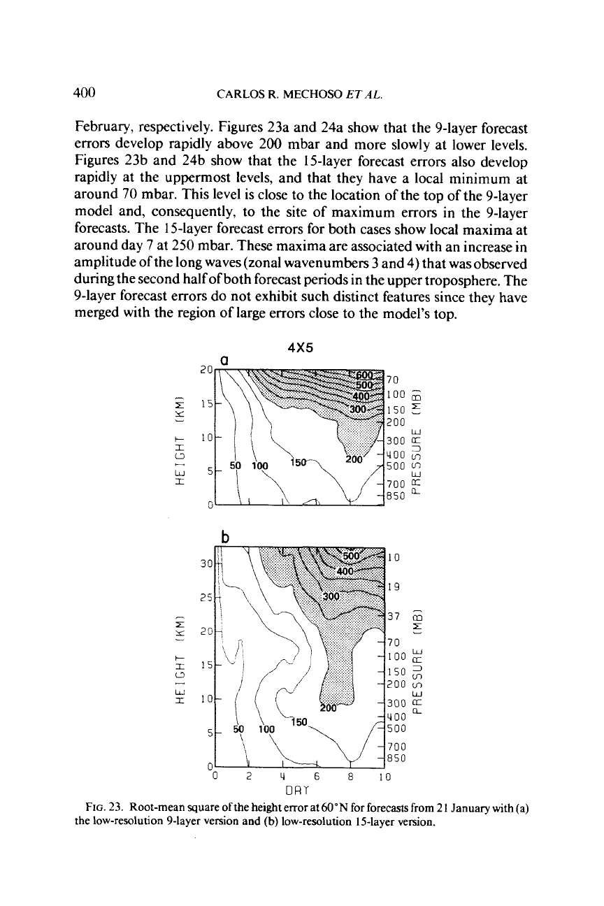
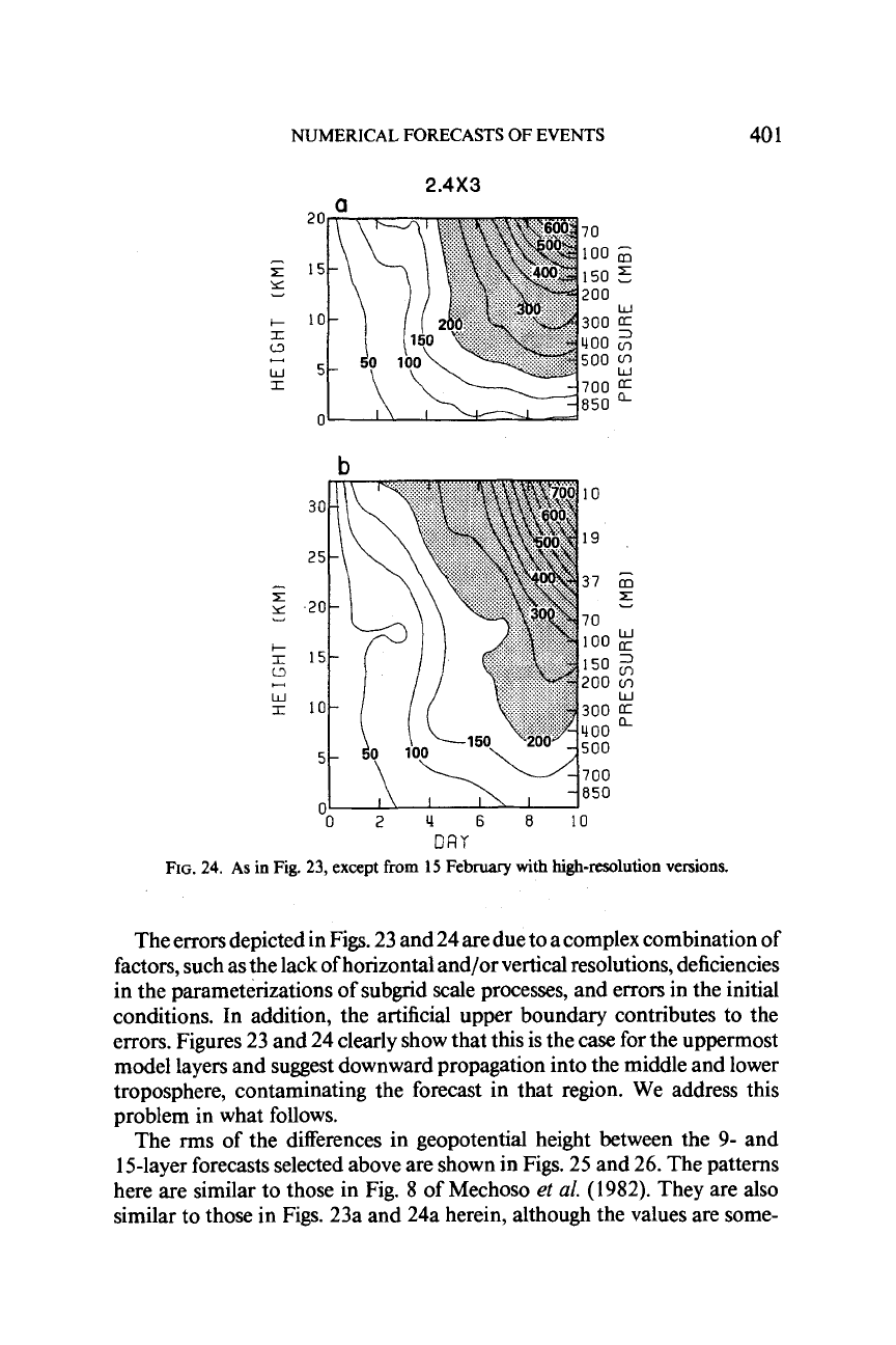
selected latitude. Figures
23
and
24
show such plots at
60"N
for the low-resolution
9-
and 15-layer forecasts
from
2
1
January, and high-resolution
9-
and 15-layer forecasts from
15
NUMERICAL FORECASTS OF EVENTS
399
15-LAYER
2.4X3
DAY 10 15-LAYER
2.4X3
FIG.
22.
As
in
Fig.
19,
except
from
15
February.
400
CARLOS
R.
MECHOSO
ET
AL
February, respectively. Figures 23a and 24a show that the 9-layer forecast
errors develop rapidly above
200
mbar and more slowly at lower levels.
Figures 23b and 24b show that the 15-layer forecast errors also develop
rapidly at the uppermost levels, and that they have a local minimum at
around
70
mbar. This level
is
close to the location of the top of the 9-layer
model and, consequently, to the site
of
maximum errors in the 9-layer
forecasts. The 15-layer forecast errors for both cases show local maxima at
around day
7
at 250 mbar. These maxima are associated with an increase in
amplitude
of
the long waves (zonal wavenumbers
3
and
4)
that was observed
during the second half ofboth forecast periods in the upper troposphere. The
9-layer forecast errors do not exhibit such distinct features since they have
merged with the region of large errors close to the model's top.
4x5
a
20
70
-
100
;;;
150
5
E
15
200
Y
b-
10
300
0
400
v,
500
w5
700
850
W
r
+-.
1
G
b
10
19
37
G
z
'O
w
150
2
100
200
cn
300
400
500
700
850
W
0
2
4
6
8
10
DRY
FIG.
23. Root-mean square ofthe height error at
60"N
for forecasts from
2
1
January
with
(a)
the low-resolution 9-layer version and
(b)
low-resolution 15-layer version.
NUMERICAL FORECASTS OF EVENTS
40
1
2.4X3
a
20
70
150
6
10
300
1100
+-..
500
w5
X
700
850
0
-
100
Y
200
E
15
r
w
-
m
5
W
a
3
cn
cn
W
a
Q
-
m
z
Y
W
3
m
cn
W
a.
a
a
DRY
FIG.
24.
As
in Fig.
23,
except
from
15
February
with
high-resolution
versions.
The errors depicted in Figs. 23 and 24 are due to a complex combination of
factors, such as the lack of horizontal and/or vertical resolutions, deficiencies
in the parameterizations
of
subgrid scale processes, and errors in the initial
conditions. In addition, the artificial upper boundary contributes
to
the
errors. Figures 23 and 24 clearly show that this is the case for the uppermost
model layers and suggest downward propagation into the middle and lower
troposphere, contaminating the forecast in that region. We address this
problem in what follows.
The rms of the differences in geopotential height between the 9- and
15-layer forecasts selected above are shown in Figs. 25 and 26. The patterns
here are similar to those in Fig.
8
of
Mechoso
et
al.
(1982). They are also
similar to those in Figs. 23a and 24a herein, although the values are some-
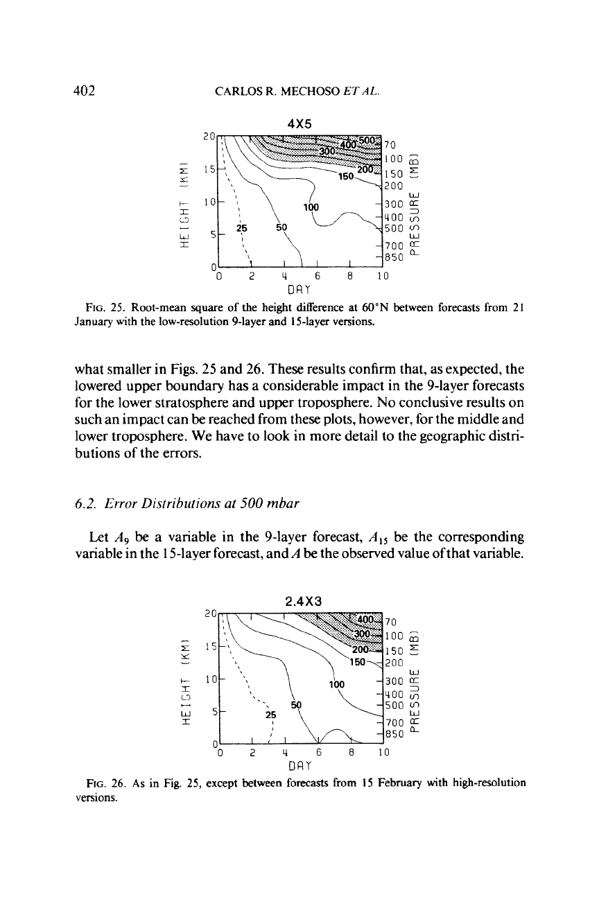
402
CARLOS R.
MECHOSO
ETAL.
4x5
70
150
5
200
300
400
v,
500
700
a
850
(L
100
6
W
02U6810
DRY
FIG.
25.
Root-mean square of the height difference at
60"N
between forecasts from
21
January with the low-resolution 9-layer and 15-layer versions.
what smaller in Figs.
25
and
26.
These results confirm that, as expected, the
lowered upper boundary has
a
considerable impact in the 9-layer forecasts
for
the lower stratosphere and upper troposphere.
No
conclusive results on
such an impact can
be
reached from these plots, however, for the middle and
lower troposphere. We have to look in more detail to the geographic distri-
butions of the errors.
6.2.
Error Distributions at
500
mbar
Let
A9
be
a variable in the 9-layer forecast,
A,,
be the corresponding
variable in the 15-layer forecast, and
A
be
the observed value ofthat variable.
2.4X3
c
I
0
w
I
-
0
2
4
6
8
10
20
70
100
150
E
15
500
700
850
0
2
4
6
8
10
DRY
FIG.
26.
As
in Fig. 25, except between forecasts
from
15 February with high-resolution
versions.
NUMERICAL FORECASTS OF EVENTS
403
FIG.
27.
The terms in
Eq.
(1)
for geopotential height at
500
mbar for the
5-day
forecast from
21
January with low-resolution versions. Term
(I),
left; term
(II),
middle; and term
(111),
right.
The contour interval is
60
m and negative values
are
shaded.
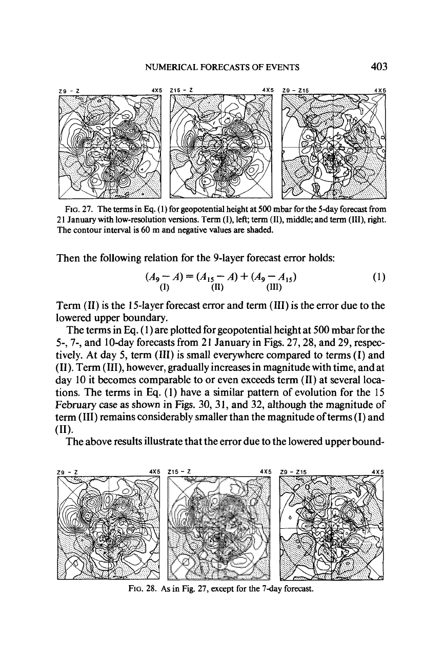
Then the following relation for the 9-layer forecast error holds:
(449
-
4
=
(4415
-
4
+
(449
-4415)
(1)
(11)
(111)
Term
(11)
is the 15-layer forecast error and term
(HI)
is
the error due to the
lowered upper boundary.
The terms in
Eq.
(
1)
are plotted for geopotential height at 500 mbar for the
5-,
7-,
and 10-day forecasts from 21 January in Figs.
27,28,
and 29, respec-
tively. At day 5, term
(111)
is small everywhere compared to terms
(I)
and
(11).
Term
(111),
however, gradually increases in magnitude with time, and at
day
10
it becomes comparable to or even exceeds term
(11)
at several loca-
tions. The terms in
Eq.
(1) have a similar pattern
of
evolution for the 15
February
case
as
shown
in Figs.
30,3
1, and
32,
although the magnitude of
term
(111)
remains considerably smaller than the magnitude of terms
(I)
and
The above results illustrate that the error due to the lowered upper bound-
(1)
(11).
FIG.
28.
As
in Fig.
27,
except for the
7day
forecast.
