Saltzman B. (editor) Anomalous Atmospheric Flows and Blocking
Подождите немного. Документ загружается.

324
1
c
0
.-
-
+G
0.0
s
E
z
a6
-
m
5
0.4
4-
.-
2
L
m
n
E
0.2
0
3
A.
J.
SIMMONS
I
I
I I
I I
I
I
I
0
12
3
4
5
6
7
8
9
10
Days
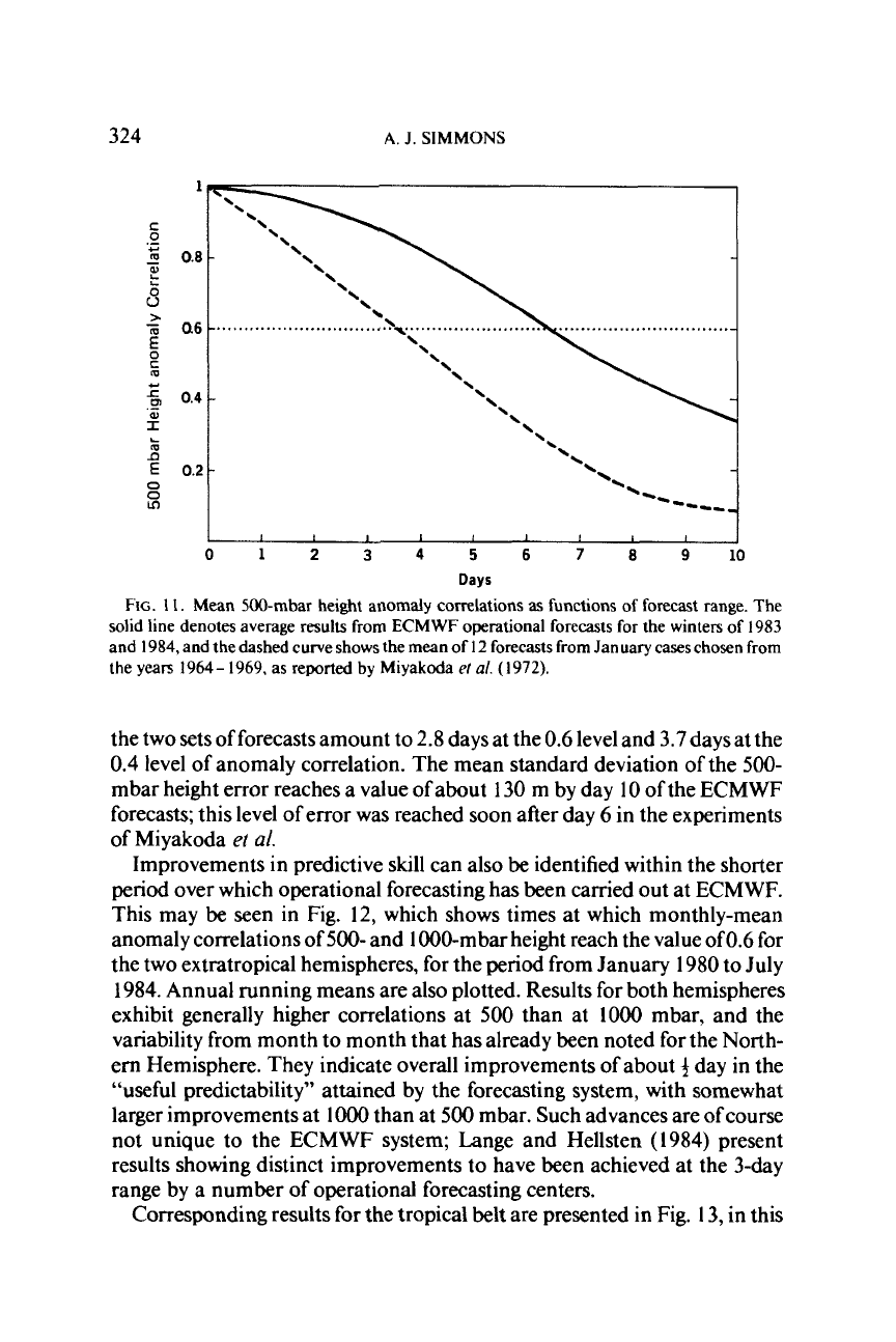
FIG.
1
1.
Mean 500-mbar height anomaly correlations
as
functions of forecast range. The
solid
line denotes average results from ECMWF operational forecasts for the winters of 1983
and 1984, and the dashed curve
shows
the mean of
I2
forecasts from January cases chosen from
the years 1964- 1969, as reported
by
Miyakoda
e/
a/.
(1972).
the two sets of forecasts amount to 2.8 days at the
0.6
level and 3.7 days at the
0.4
level of anomaly correlation. The mean standard deviation of the
500-
mbar height error reaches a value
of
about
130
m by day
10
of the ECMWF
forecasts; this level of error was reached soon after day
6
in the experiments
of Miyakoda
et
al.
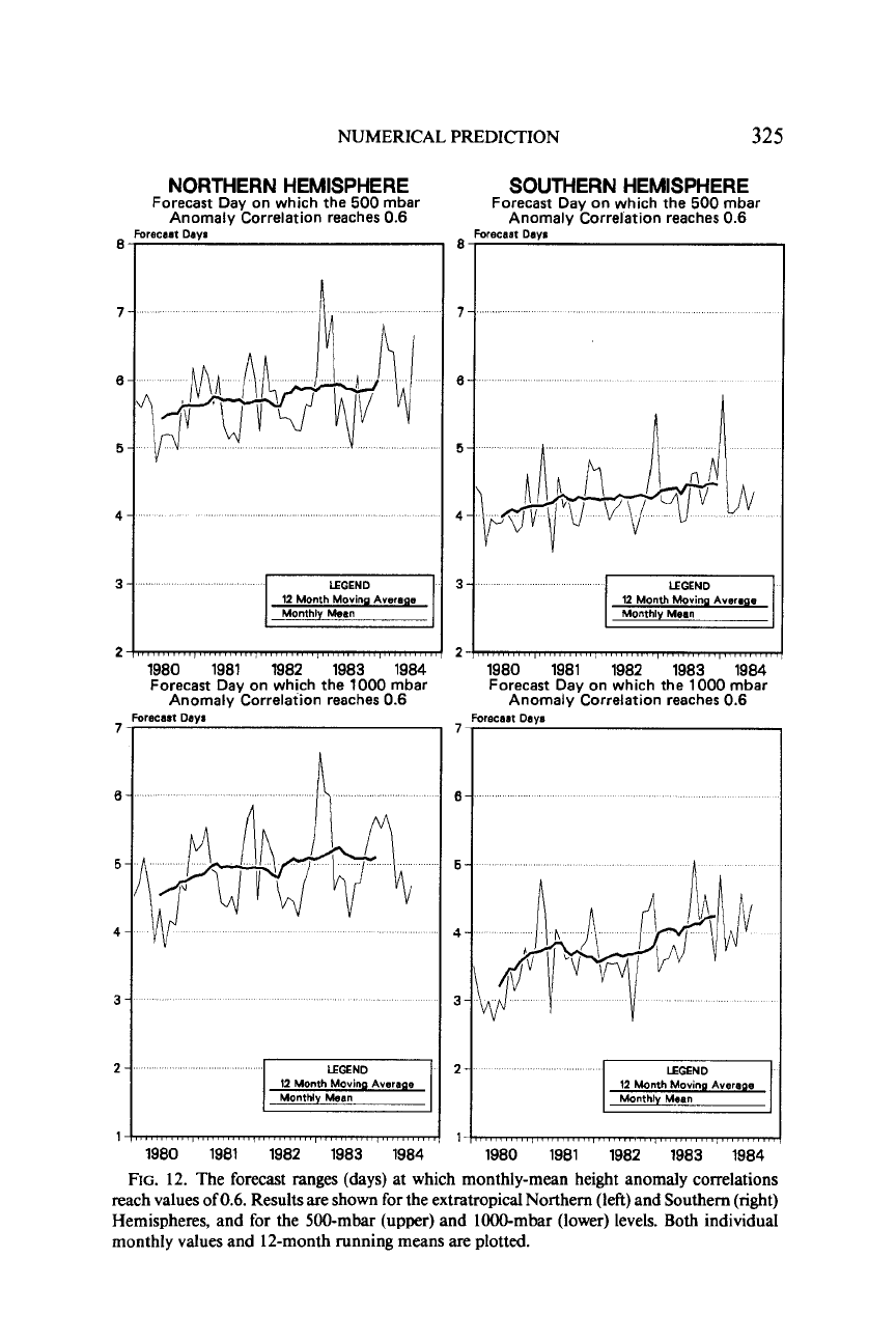
Improvements in predictive skill can also be identified within the shorter
period over which operational forecasting has been carried out at ECMWF.
This may
be
seen in Fig. 12, which shows times at which monthly-mean
anomaly correlations of
500-
and 1000-mbar height reach the value of0.6 for
the two extratropical hemispheres, for the period from January 1980 to July
1984. Annual running means are also plotted. Results for both hemispheres
exhibit generally higher correlations at
500
than at
1000
mbar, and the
variability from month to month that has already been noted for the North-
ern Hemisphere. They indicate overall improvements
of
about
+
day in the
“useful predictability” attained by the forecasting system, with somewhat
larger improvements at
lo00
than at
500
mbar. Such advances are ofcourse
not unique to the ECMWF system; Lange and Hellsten (1984) present
results showing distinct improvements to have been achieved at the 3-day
range by a number of operational forecasting centers.
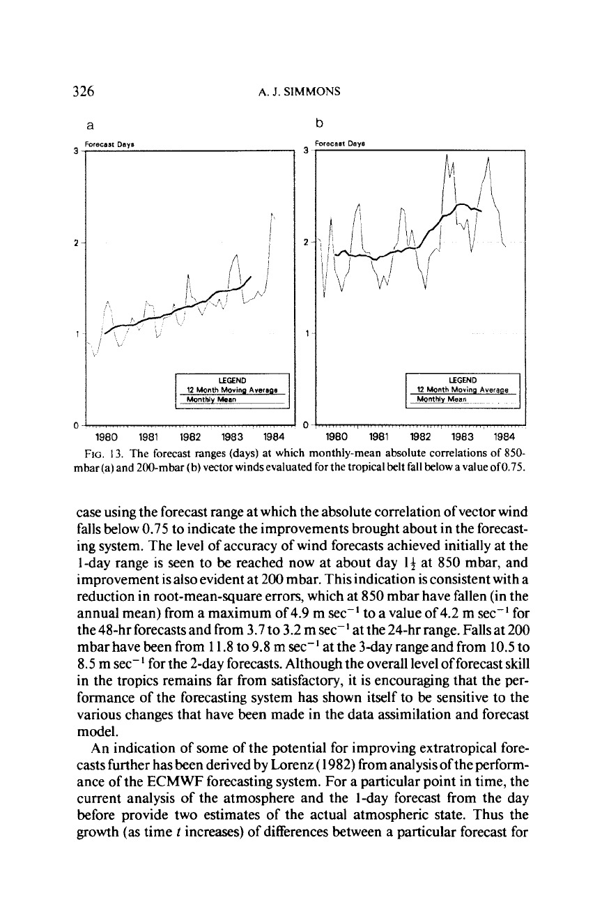
Corresponding results for the tropical belt are presented in Fig. 13, in this
NUMERICAL PREDICTION
325
NORTHERN
HEMISPHERE
Forecast Day on which the
500
mbar
Anomaly Correlation reaches
0.6
'1
'1
LEGEND
12 Month
Moviw Average
21
1980 1981 1982 1983 1984
Forecast Day on which the
1000
mbar
Anomaly Correlation reaches
0.6
'1
3
I
LEGEND
II
2
12 Month
Movina Averaoe
1
Monthly Mean
1m1
1980 1981 1982 1983 1984
SOUTHERN
HEMISPHERE
Forecast Day on which the
500
mbar
Anomaly Correlation reaches
0.6
recast
Dayr
LEGEND
I
12 Month
Moving Average
1980 1981 1982 1983 1984
Forecast Day on which the
1000
mbar
Anomaly Correlation reaches
0.6
Forecast
Diva
LEGEND
12 Month
Moving
Average
Monthly Mean
1980 1981 1982 1983 1984
FIG.
12. The forecast ranges (days) at which monthly-mean height anomaly correlations
reach values of
0.6.
Results are shown for the extratropical Northern (left) and Southern (right)
Hemispheres, and for the 500-mbar (upper) and 1000-mbar (lower) levels. Both individual
monthly values and 12-month running means are plotted.
326
A.
J.
SIMMONS
a
recast
Days
12
Month
Movinq
Averape
1980 1981 1982 1983 1984
b
weca~t
Days
12
Month
Movmg
Average
-
,,
,,,
/.
,.
-,,~
,.,,,,,,,
1980 1981 1982 1983 1984
FIG.
13.
The forecast ranges (days) at which monthly-mean absolute correlations
of
850-
mbar (a) and 200-mbar (b)
vector
winds evaluated for the tropical belt fall below a value
of0.75.
case using the forecast range at which the absolute correlation of vector wind
falls below 0.75
to
indicate the improvements brought about in the forecast-
ing system. The level of accuracy of wind forecasts achieved initially at the
1-day range is seen to be reached now at about day
14
at 850 mbar, and
improvement is also evident at 200 mbar. This indication is consistent with a
reduction in root-mean-square errors, which at 850 mbar have fallen (in the
annual mean) from a maximum of
4.9
m sec-I to a value of 4.2 m sec-I for
the 48-hr forecasts and from 3.7 to 3.2 m sec-' at the 24-hr range. Fallsat
200
mbar have been from
1
1.8 to 9.8 m sec-' at the 3-day range and from
10.5
to
8.5
m sec-l for the 2-day forecasts. Although the overall level of forecast skill
in the tropics remains far from satisfactory, it is encouraging that the per-
formance of the forecasting system has shown itself to be sensitive to the
various changes that have been made in the data assimilation and forecast
model.
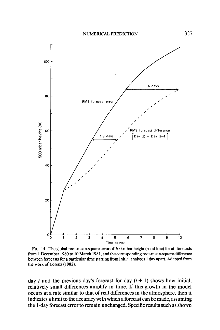
An indication of some
of
the potential for improving extratropical fore-
casts further has been derived by Lorenz
(
1982) from analysis of the perform-
ance of the ECMWF forecasting system. For a particular point in time, the
current analysis
of
the atmosphere and the 1-day forecast from the day
before provide two estimates
of
the actual atmospheric state. Thus the
growth (as time
t
increases)
of
differences between a particular forecast for
NUMERICAL PREDICTION
327
100
80
-
E
-
60
.-
0
A=
L
4
5:
E
0
40
20
0
.
.
0
,
RMS
forecast error
0
,
,
I
RMS
forecast dlfference
1
9
days
/
'
[Day (t)
-
Day (t-1)
I
I
1
I
I
I
I
I
01
2
3
4
5
6
7
8
9
10
Time
(days)
FIG.
14.
The global root-mean-square error of 500-mbar height (solid line) for
all
forecasts
from
1
December
1980
to
10
March
I98
1,
and the corresponding root-mean-square difference
between forecasts for a particular time starting from initial analyses
1
day apart. Adapted from
the
work
of Lorenz
(
1982).
day
t
and the previous day's forecast for day
(t
+
1)
shows how initial,
relatively small differences amplify in time. If this growth in the model
occurs at a rate similar to that of real differences in the atmosphere, then it
indicates a limit to the accuracy with which a forecast can be made, assuming
the
1
-day forecast error to remain unchanged. Specific results such as shown
328
A.
J.
SIMMONS
in Fig. 14 suggest a maximum possible improvement of about
2
days at the
level of predictability currently reached at day 3, and about
4
days at the level
now reached at day 6. Further improvements would result from increased
accuracy of the lday forecast and Lorenz argues that halving the 1-day
root-mean-square error should add 2 days to the range of predictability.
To
put such a reduction in context, present ECMWF results for winter indicate a
1
-day error which is
40%
of the value reported by Miyakoda
et
al.
(
1972).
Thus an average limit of deterministic predictability of the order of
2
weeks
or more is indicated, a result in general agreement with earlier estimates
discussed by Charney
et
al.
(
1966) and Smagorinsky
(
1969).
7.
THE REPRESENTATION
OF
MONTHLY-MEAN ANOMALIES
Some results of relevance to the longer-rage prediction of large-scale
anomalies may
be
obtained by examining the extent to which observed
monthly-mean deviations from climatology are present in the day
10
fore-
cast fields. For example, Bengtsson and Simmons (1983) illustrate how the
mean
of
all ECMWF forecasts for
10
days ahead produced daily during July
1980 succeeded in representing the temperature anomaly associated with a
major heat wave and drought over southeastern North America. Such an
anomaly was,
of
course, present in the initial conditions for the predictions,
but the forecast model (which used a number ofclimatological initial surface
conditions) was evidently capable of maintaining the strength of the anom-
aly over at least a 10-day period.
A
brief examination of the treatment of Northern Hemispheric 500-mbar
height anomalies during the winter months of 1980/1981 and 1981/1982
has been camed out and some objective verification of day
10
forecasts is
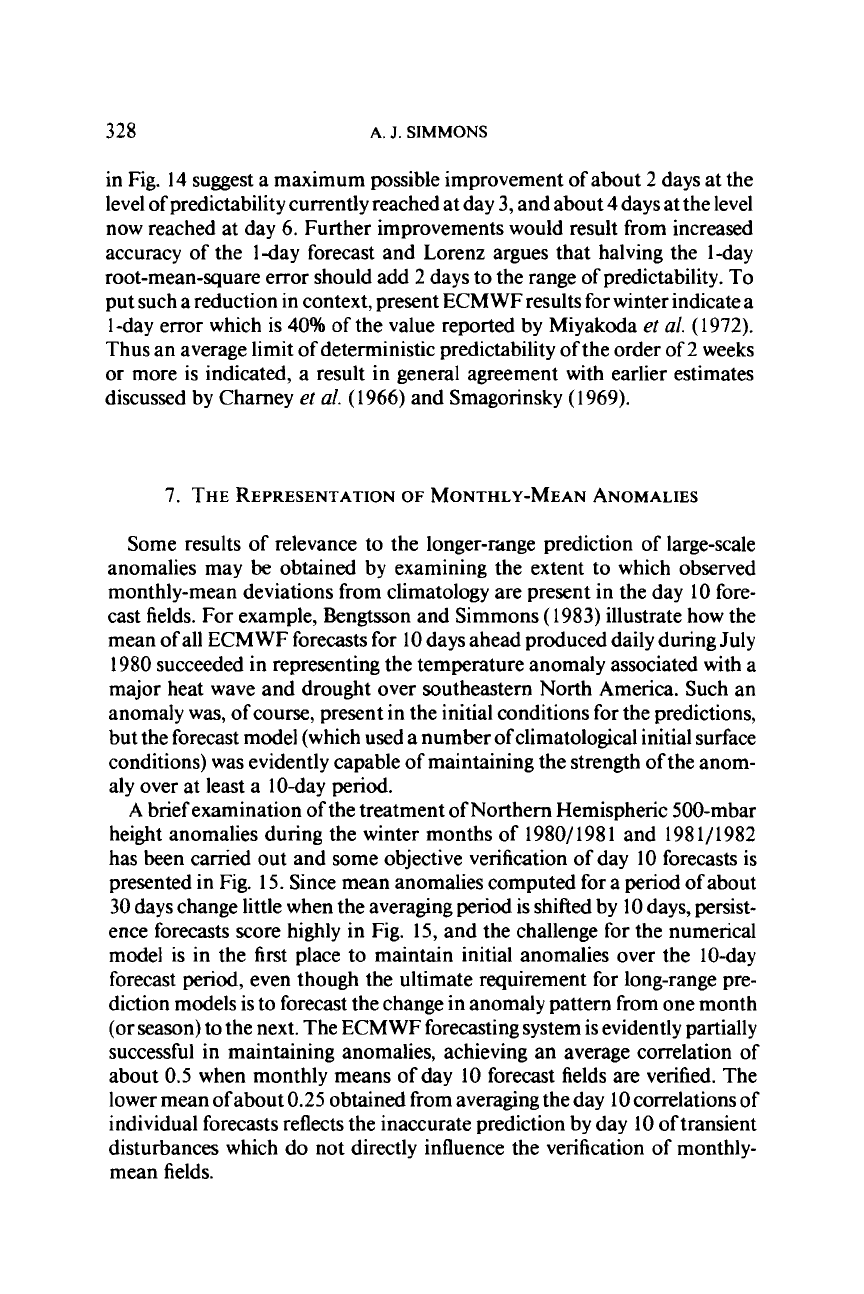
presented in Fig. 15. Since mean anomalies computed for a
period
of about
30
days
change little when the averaging period is shifted
by
10
days, persist-
ence forecasts score highly in Fig. 15, and the challenge for the numerical
model is in the first place to maintain initial anomalies over the 10-day
forecast period, even though the ultimate requirement for long-range pre-
diction models is to forecast the change in anomaly pattern from one month
(or season) to the next. The ECMWF forecasting system is evidently partially
successful in maintaining anomalies, achieving an average correlation
of
about
0.5
when monthly means of day
10
forecast fields are verified. The
lower mean
of
about
0.25
obtained from averaging the day
10
correlations of
individual forecasts reflects the inaccurate prediction by day 10 of transient
disturbances which do not directly influence the verification of monthly-
mean fields.
NUMERICAL
PREDICTION
329
i
c
0
+.'
m
.-
-
0.75
8
.. ..
....a*
*'I
*..
.
.:
,.
,\
*'
I
I
I\
I
I
I
I
I I I
I
I
NDJ
F
M'
'
NDJ
FM
1980 1981 1982
FIG.
15.
Monthly-mean 500-mbar height anomaly correlations
for
the extratropical
North-
em Hemisphere.
(-)
Mean
of
anomaly correlations
of
day
10 forecasts;
(---)
anomaly
correlation
of
mean
of
day
10
forecasts;
(
-
-
)
anomaly correlation
of
mean
of
day
10
persist-
ence
forecasts.
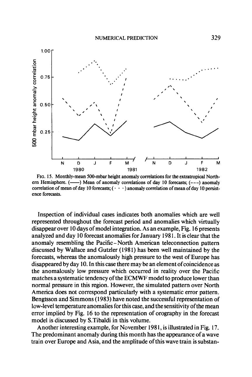
Inspection of individual cases indicates both anomalies which are well
represented throughout the forecast period and anomalies which virtually
disappear over 10 days of model integration. As an example, Fig. 16 presents
analyzed and day 10 forecast anomalies for January 198
I.
It is clear that the
anomaly resembling the Pacific- North American teleconnection pattern
discussed by Wallace and Gutzler (1981) has been well maintained by the
forecasts, whereas the anomalously high pressure to the west
of
Europe has
disappeared by day
10.
In this case there may
be
an element of coincidence as
the anomalously low pressure which occurred
in
reality over the Pacific
matches a systematic tendency of the ECMWF model to produce lower than
normal pressure in this region. However, the simulated pattern over North
America does not correspond particularly with a systematic error pattern.
Bengtsson and Simmons (1 983) have noted the successful representation of
low-level temperature anomalies for this case, and the sensitivity of the mean
error implied by Fig.
16
to the representation of orography in the forecast
model is discussed by S.Tibaldi in this volume.
Another interesting example, for November 198
1,
is illustrated in Fig. 17.
The predominant anomaly during this month has the appearance of a wave
train over Europe and Asia, and the amplitude of this wave train is substan-
ANALYSIS
FORECAST
Iyh
1-
15C-C
.....
..
I.
i
1.
...
\.
~ d.,
..........
FIG.
16.
The mean deviation of the 500-mbar height from climatology
for
January
1981
(upper), and the corresponding anomaly computed
from
all day
10
forecasts verifying within
this month (lower). The zero contour is dotted, and negative contours dashed. The contour
interval is
4
dam.
NUMERICAL PREDICTION
ANALYSIS
33
1
FORECAST
FIG.
17.
As
in
Fig.
16,
but
for
November
198
1.
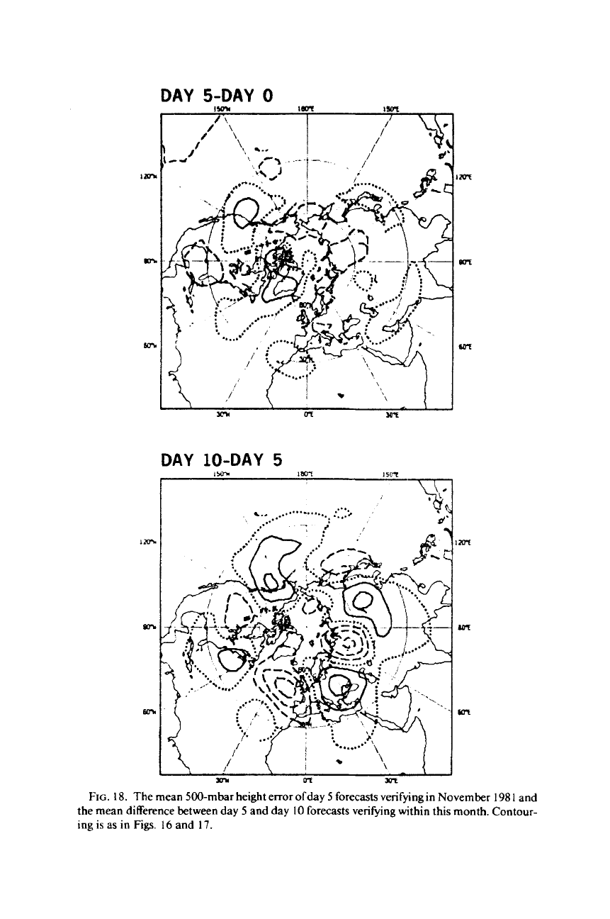
DAY 5-DAY
0
1981
and
Contour-
FIG.
18.
The mean 500-mbar height error ofday
5
forecasts verifying in November
198
I
and
the mean difference between day
5
and day
10
forecasts verifying within this month. Contour-
ing
is as
in
Figs.
16
and
17.
NUMERICAL PREDICTION
333
tially weakened over all but its easternward limit in the mean of the day
10
forecasts. A wave train of smaller amplitude extending over North America
from the Pacific to the Atlantic can also
be
seen to decay over the forecast
period. Figure
18
shows that almost all of the weakening of the monthly-
mean anomaly pattern occurs in the second half of the forecast period.
Further diagnosis would
be
required to determine the reason for this result,
but it could, for example,
be
that the model misrepresents a localized remote
forcing or propagation which does not influence middle latitudes until day
5
or later. In any case,
it
would appear from these examples that the archived
results from operational medium-range prediction form a valuable data
source which may
be
diagnosed to further the understanding and numerical
modeling of short-term climatic anomalies.
8.
SYSTEMATIC
MODEL
ERRORS
Examination of monthly-mean maps such as discussed in the preceding
section shows a tendency for certain errors to recur. These “systematic
errors” characteristically grow in amplitude throughout the forecast period,
and their general similarity to errors in the model climatology revealed by
integration over extended periods indicates that their growth represents a
gradual drift from the climate of the atmosphere
(as
represented by the
average of many initid states) to the climate of the model. The rate of this
drift is found to vary from case to case, but the overall nature of the errors
appears to
be
independent of the initial data. The errors can be recognized in
substantial distortions of the flow pattern within individual forecasts toward
the end of the 10-day range, and for longer range prediction they may act to
destroy predictability by, for example, causing an erroneous response to
anomalous surface forcing which cannot
be
corrected in a simple statistical
way.
A
particularly important error of the ECMWF forecast model, and indeed
of a number of other prediction and climate models
(as
discussed, for exam-
ple, by Wallace
et
al.,
1983,
or Simmons and Bengtsson,
1984),
occurs in the
representation of the large-scale quasi-stationary wave patterns of the extra-
tropical hemispheres. At the surface, centers of erroneously low pressure are
characteristically found over the eastern Atlantic and Pacific Oceans, with
too zonal
a
flow over North America and Europe. Stationary wave patterns
in the middle and upper troposphere are typically weakened in both hemi-
spheres. Over Europe this appears as a southward shift of the jetstream over
the northern part of the continent, with a related erroneous track oftransient
disturbances, and an eastward shift of the mean trough over the eastern
Mediterranean.
A
manifestation of the latter within an individual forecast