Richards J.A., Jia X. Remote Sensing Digital Image Analysis: An Introduction
Подождите немного. Документ загружается.


152 6 Multispectral Transformations of Image Data
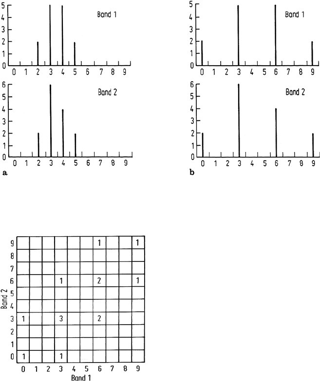
Fig. 6.9. a Individual histograms for the image with the two dimensional histogram of Fig. 6.8;
b The individual histograms after a simple linear contrast stretch over all available brightness
values
Fig. 6.10. Histogram of a two dimensional im-
age after simple linear contrast stretch of the
components individually
is still present and that if component 1 is displayed as red and component 2 as green,
no highly saturated reds or greens will be evident in the enhanced image, although
brighter yellows will be more obvious than in the original data. It is a direct result
of the correlation in the image that the highly saturated colour primaries are not dis-
played. The situation is even worse for display of three dimensional correlated image
data. Simple contrast enhancement of each component independently will yield an
image without highly saturated reds, blues and greens but also without saturated yel-
lows, cyans and magentas. The procedure recommended by Taylor overcomes this,
as demonstrated now. This fills the available colour space on the display more fully.
6.1 The Principal Components Transformation 153
Let x be the vector of brightness values of the pixels in the original image and y
be the corresponding vector of intensities after principal components transformation,
such that y = Gx. G is the principal components transformation matrix, composed
of transposed eigenvectors of the original covariance matrix Σ
x
. The covariance
matrix which describes the scatter of pixel points in the principal components (y)
vector space is a diagonal matrix of eigenvalues which, for three dimensional data,
is of the form
Σ
y
=
⎡
⎣
λ
1
00
0 λ
2
0
00λ
3
⎤
⎦
Suppose now the individual principal components are enhanced in contrast such that
they each cover the corresponding range of brightness values and, in addition, have
the same variances; in other words the histograms of the principal components are
matched, for example, to a Gaussian histogram that has the same variance in all
dimensions. The new covariance matrix will therefore be of the form
Σ
y
=
⎡
⎣
σ
2
00
0 σ
2
0
00σ
2
⎤
⎦
= σ
2
I
where I is the identity matrix. Since the principal components are uncorrelated, en-
hancement of the components independently yields an image with good utilisation
of the available colour space, with all hues possible. The axes in the colour space
however are principal components axes and, as noted in the previous section, are not
as desirable for photointerpretation as having a colour space based upon the original
components of the image. It would be of particular value therefore if the image data
could be returned to the original x space to give a one-to-one mapping between the
display colours and image components. Let the contrast enhanced principal compo-
nents be represented by the vector y
. These can be transformed back to the original
axes for the image by using the inverse of the principal components transformation
matrix G
−1
. Since G is orthogonal its inverse is simply its transpose, which is readily
available. The new covariance matrix of the data back in the original image domain is
Σ
x
= G
t
E{(y
− E(y
))(y
− E(y
))}
t
G
where x
= G
t
y
, is the modified pixel vector in the original space. Consequently
Σ
x
=G
t
E{(y
− E(y
))(y
− E(y
))}
t
G
=G
t
Σ
y
G
=G
t
σ
2
IG
i.e. Σ
x
=σ
2
I.
Thus the covariance matrix of the enhanced principal components data is preserved
on transformation back to the original image space. No correlation is introduced
and the data shows good utilisation of the colour space using the original image
data components. In practice, one problem encountered with the Taylor procedure
is the noise introduced into the final results by the contrast enhanced third principal
154 6 Multispectral Transformations of Image Data
component. Should all possible brightness values be available in the components this
would not occur. However because most image analysis software treats image data in
integer format in the range 0 to 255, rounding of intermediate results to integer form
produces the noise. One possible remedy is to filter the noisy components before the
inverse transform is carried out.
It will be appreciated from the foregoing discussion that colour composite princi-
pal component imagery will appear more colourful than a colour composite product
formed from original image bands. This is a direct result of the ability to fill the colour
space completely by contrast enhancing the uncorrelated components, by compar-
ison to the poor utilization of colour by the original correlated data, as seen in the
illustration of Fig. 6.10 and as demonstrated in Fig. 6.6c.
6.1.7
Other Applications of Principal Components Analysis
Owing to the information compression properties of the principal components trans-
formation it lends itself to reduced representation of image data for storage or trans-
mission. In such a situation only the uppermost significant components are retained
as a representation of an image, with the information content so lost being indicated
by the sum of the eigenvalues corresponding to the components ignored. Thereafter
if the original image is to be restored, either on reception through a communications
channel or on retrieval from memory, then the inverse of the transformation ma-
trix is used to reconstruct the image from the reduced set of components. Since the
matrix is orthogonal its inverse is simply its transpose. This technique is known as
bandwidth compression in the field of telecommunications. Until recently it had not
found great application in satellite remote sensing image processing, because hith-
erto image transmission has not been a consideration and available memory has not
placed stringent limits on image storage. With increasing use of imaging spectrom-
etry data however (Sect. 1.2), bandwidth compression has become more important,
as discussed in Sect. 13.8.
An interesting application of principal components analysis is in the detection of
features that change with time between images of the same region. This is described
by example in Chap. 11.
6.2
Noise Adjusted Principal Components Transformation
In the example of Fig. 6.6 it is apparent that any noise present in the original image
has been concentrated in the later principal components. Ordinarily that is what
would be expected: ie. that the components would become progressively noisier as
their eigenvalues decrease. In practice, however, that is not always the case. It is
found, sometimes, that earlier components are noisier than those with the smallest
eigenvalues. The noise adjusted transformation overcomes that problem (Lee et al,
1990).

6.2 Noise Adjusted Principal Components Transformation 155
Let
y = Gx = D
t
x (6.10)
be a transformation that will achieve what we want. As with the principal components
transformation, if Σ
x
is the covariance of the data in the original (as recorded) co-
ordinate system, then the covariance matrix after transformation will be
Σ
y
= D
t
Σ
x
D (6.11)
To find the value for the transformation matrix D
t
that will order the noise by com-
ponent we start by defining the noise fraction
γ =
v
n
v
(6.12)
where v
n
is the noise variance along a particular axis (i.e. in a given band) and
v is the total variance along that axis (in that band), consisting of the sum of the
signal (wanted) variance and the noise variance, assuming the signal and noise are
uncorrelated. The total noise variance over all bands in the recorded data can be
expressed as a noise covariance matrix Σ
n
x
so that after transformation according to
(6.10) the noise covariance matrix will be
Σ
n
y
= D
t
Σ
n
x
D (6.13)
Along one particular axis (g) the noise and total variances are then
v
n
=d
t
Σ
n
x
d
v =d
t
Σ
x
d
so that (6.12) becomes
γ =
d
t
Σ
n
x
d
d
t
Σ
x
d
(6.14)
We now want to find that new coordinate direction g = d
t
that minimises γ .Todo
so, we take the first derivative of γ with respect to d zero.
Noting that
∂
∂x
{x
t
Ax}=2Ax then we have from (6.14)
∂γ
∂d
=2Σ
n
x
d{d
t
Σ
x
d}
−1
− 2Σ
x
d{d
t
Σ
x
d}
−2
{d
t
Σ
n
x
d}
=0
which, after simplification, leads to
Σ
n
x
d − Σ
x
d
d
t
Σ
n
x
d
d
t
Σ
x
d
= 0
or (Σ
n
x
− Σ
x
γ)d = 0
so that (Σ
n
x
Σ
−1
x
− γI)d = 0 (6.15)
Thus the γ are the eigenvalues of Σ
n
x
Σ
−1
x
and d are the associated eigenvectors.
If we rank the eigenvalues in increasing order, then the image components will be
ranked from that with the lowest noise variance to that with the highest, as required.
156 6 Multispectral Transformations of Image Data
Suppose now the noise covariance can be transformed to the identity matrix I
(we will see how to do that below), then (6.15) becomes
(Σ
−1
x
− γI)d = 0
Also, since Σ
n
x
= I then γ = v
−1
, so that the last expression can be written, after
multiplying throughout by Σ
x
,
(Σ
x
− vI)d = 0
which is the standard eigenvalue equation associated with the usual principal compo-
nents transformation. Note, as expected that v, the eigenvalue, is now explicitly the
image variance in the relevant band, as might be expected. Therefore we now have
a simple way to apply the noise adjusted principal components transformation – ie
to ensure that the transformed images are ranked in increasing order of noise vari-
ance: first we transform the original data such that its noise covariance is the identity
matrix, and then we apply the standard principal components procedure.
The only outstanding step is to know how to transform the data so it has a unity
noise covariance. That can be achieved in the following manner.
From Appendix D we see that a diagonal form for Σ
n
x
is
= E
−1
Σ
n
x
E
in which is the diagonal matrix of its eigenvalues and E is the matrix of its
eigenvectors. However, we want the diagonal form to be the identity matrix. To
generate that we pre-multiply the last expression by
−1/2t
and post-multiply it by
−1/2
so that we end up with
I =
(−1/2)t
E
−1
Σ
n
x
E
−1/2
If we define F = E
−1/2
, so that
I = F
t
Σ
n
x
F
we recognise y = F
t
x as the transformation of the original data that will yield a new
data set in which the noise covariance matrix is unity. Provided this transformation is
carried out first (which involves finding or estimating the noise covariance, and then
finding its eigenvalues and eigenvectors) then the standard principal components
transformation can be applied.
There are several ways the noise content of an image can be estimated. Many
are based on examining the local properties of an image in segments thought to
represent homogeneous regions on the ground. For those areas the residual data
created by subtracting a smoothed version of the image from the original is assumed
to represent noise. Olsen (1993) provides an overview of noise estimation methods.
6.3
The Kauth-Thomas Tasseled Cap Transformation
The principal components transformation treated in Sects. 6.1 and 6.2 yields a new
co-ordinate description of multispectral remote sensing image data by establishing a

6.3 The Kauth-Thomas Tasseled Cap Transformation 157
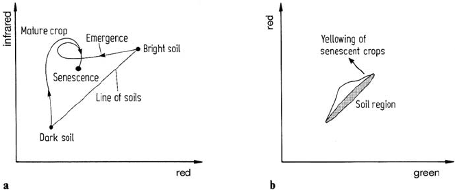
Fig. 6.11. a Infrared versus red subspace showing trajectories of crop development; b Red
versus green subspace also depicting crop development
diagonal form of the global covariance matrix. The new co-ordinates (components)
are linear combinations of the original spectral bands. Other linear transformations
are of course possible. One is a procedure referred to as canonical analysis, treated
in Chap. 10. Another, to be developed below, is application-specific in that the new
axes in which data are described have been devised to maximise information of
importance, in this case, to agriculture. Other similar special transformations would
also be possible.
The so-called “tasseled cap” transformation (Crist and Kauth, 1986) developed by
Kauth and Thomas (1976) is a means for highlighting the most important (spectrally
observable) phenomena of crop development in a way that allows discrimination
of specific crops, and crops from other vegetative cover, in Landsat multitemporal,
multispectral imagery. Its basis originally lies in an observation of crop trajectories
in band 6 versus band 5, and band 5 versus band 4 subspaces. Consider the former
as shown in Fig. 6.11a.
A first observation that can be made is that the variety of soil types on which
specific crops might be planted appear as points along a diagonal in an infrared, red
space as shown. This is well-known and can be assessed from an observation of the
spectral reflectance characteristics for soils. (See for example Chap. 5 of Swain and
Davis, 1978.) Darker soils lie nearer the origin and lighter soils at higher values in
both bands. The actual slope of this line of soils will depend upon global external
variables such as atmospheric haze and soil moisture effects. If the transformation
to be derived is to be used quantitatively these effects need to be modelled and the
data calibrated or corrected beforehand.
Consider now the trajectories followed in infrared versus red subspace for crop
pixels corresponding to growth on different soils – in this case take the extreme light
and dark soils as depicted in Fig. 6.11a. For both regions at planting the multispectral
response is dominated by soil types, as expected. As the crops emerge the shadows
cast over the soil dominate any green matter response.As a result there is considerable
darkening of the response of the lighter soil crop field and only a slight darkening

158 6 Multispectral Transformations of Image Data
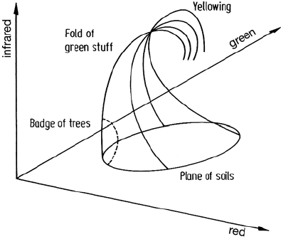
Fig. 6.12. Crop trajectories in a
green, red, infrared space, having
the appearance of a tasseled cap
of that on dark soil. When both crops reach maturity their trajectories come together
implying closure of the crop canopy over the soil. The response is then dominated
by the green biomass, being in a high infrared and low red region, as is well known.
When the crops senesce and turn yellow their trajectories remain together and move
away from the green biomass point in the manner depicted in the diagram. However
whereas the development to maturity takes place almost totally in the same plane,
the yellowing development in fact moves out of this plane, as can be assessed by
how the trajectories develop in the red versus green subspace during senescence as
illustrated in Fig. 6.11b.
Should the crops then be harvested, the trajectories beyond senescence move, in
principle, back towards their original soil positions.
Having made these observations, the two diagrams of Fig. 6.11 can now be
combined into a single three dimensional version in which the stages of the crop
trajectories can be described according to the parts of a cap, with tassels, from which
the name of the subsequent transformation is derived. This is shown in Fig. 6.12. The
first point to note is that the line of soils used in Fig. 6.11a is shown now as a plane
of soils. Its maximum spread is along the three dimensional diagonal as indicated;
however it has a scatter about this line consistent with the spread in red versus green
as shown in Fig. 6.11b. Kauth and Thomas note that this plane of soils forms the brim
and base of the cap. As crops develop on any soil type their trajectories converge
essentially towards the crown of the cap at maturity whereupon they fold over and
continue to yellowing as indicated. Thereafter they break up to return ultimately to
various soil positions, forming tassels on the cap as shown.
The behaviour observable in Fig. 6.12 led Kauth and Thomas to consider the
development of a linear transformation that would be useful in crop discrimination.
As with the principal components transform, this transformation will yield four or-
thogonal axes. However the axis directions are chosen according to the behaviour
seen in Fig. 6.12.
6.3 The Kauth-Thomas Tasseled Cap Transformation 159
Three major orthogonal directions of significance in agriculture can be identi-
fied. The first is the principal diagonal along which soils are distributed. This was
chosen by Kauth and Thomas as the first axis in the tasseled cap transformation.
The development of green biomass as crops move towards maturity appears to occur
orthogonal to the soil major axis. This direction was then chosen as the second axis,
with the intention of providing a greeness indicator. Crop yellowing takes place in
a different plane to maturity. Consequently choosing a third axis orthogonal to the
soil line and greeness axis will give a yellowness measure. Finally a fourth axis is
required to account for data variance not substantially associated with differences in
soil brightness or vegetative greeness or yellowness. Again this needs to be orthogo-
nal to the previous three. It was called “non-such” by Kauth and Thomas in contrast
to the names “soil brightness”, “green-stuff” and “yellow-stuff” they applied to the
previous three.
The transformation that produces the new description of the data may be ex-
pressed as
u = Rx + c (6.16)
where x is the original Landsat vector, and u is the vector of transformed brightness
values. This has soil brightness as its first component, greeness as its second and
yellowness as its third. These can therefore be used as indices, respectively. R is the
transformation matrix and c is a constant vector chosen (arbitrarily) to avoid negative
values in u.
The transformation matrix R is the transposed matrix of column unit vectors along
each of the transformed axes (compare with the principal components transformation
matrix). For a particular agricultural region Kauth and Thomas chose the first unit
vector as a line of best fit through a set of soil classes. The subsequent unit vectors were
generated by using a Gram-Schmidt orthogonalization procedure in the directions
required. The transformation matrix generated for Landsat MSS data was
R =
⎡
⎢
⎢
⎣
0.433 0.632 0.586 0.264
−0.290 −0.562 0.600 0.491
−0.829 0.522 −0.039 0.194
0.223 0.012 −0.543 0.810
⎤
⎥
⎥
⎦
From this it can be seen, at least for the region investigated by Kauth and Thomas,
that the soil brightness is a weighted sum of the original four Landsat bands with
approximately equal emphasis. The greeness measure is the difference between the
infrared and visible responses. In a sense therefore this is more a biomass index.
The yellowness measure can be seen to be substantially the difference between the
Landsat visible red and green bands.
Just as new images can be synthesised to correspond to various principal compo-
nents so can the actual transformed images be created for this approach. By applying
(6.16) to every pixel in a Landsat multispectral scanner image, soil brightness, gree-
ness, yellowness and non-such images can be produced. These can then be used to
assess stages in crop development. The method can also be applied to other sensors.

160 6 Multispectral Transformations of Image Data
6.4
Image Arithmetic, Band Ratios and Vegetation Indices
Addition, subtraction, multiplication and division of the pixel brightnesses from two
bands of image data to form a new image are particularly simple transformations to
apply. Multiplication seems not to be as useful as the others, band differences and
ratios being most common.
Differences can be used to highlight regions of change between two images
of the same area. This requires that the images be registered using the techniques
of Chap. 2 beforehand. The resultant difference image must be scaled to remove
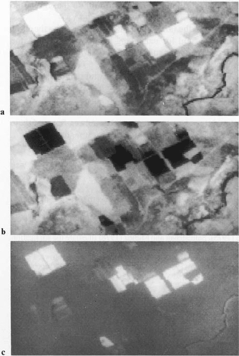
Fig. 6.13. Landsat multispectral scanner band 7 a and band 5, b images of an arid region
containing irrigated crop fields. The ratio of these two images c shows vegetated regions as
bright, soils as mid to dark grey and water as black
References for Chapter 6 161
negative brightness values. Normally this is done so that regions of no change appear
mid-grey, with changes shown as brighter or duller than mid-grey according to the
sign of the difference.
Ratios of different spectral bands from the same image find use in reducing the
effect of topography, as a vegetation index, and for enhancing subtle differences in
the spectral reflectance characteristics for rocks and soils. As an illustration of the
value of band ratios for providing a single vegetation index image, Fig. 6.13 shows
Landsat multispectral scanner band 5 and band 7 images of an agricultural region
along with the band 7/band 5 ratio. As seen, healthy vegetated areas are bright, soils
are mid to dark grey, and water is black. These shades are readily understood from an
examination of the corresponding spectral reflectance curves. Variations on simple
arithmetic operations between bands are also sometimes used as indices. Some of
these are treated in Sect. 10.4.6. Note that band ratioing is not a linear transformation.
References for Chapter 6
An easily read treatment of the principal components transformation has been given by Jensen
and Waltz (1979), although the degree of mathematical detail has been kept to a minimum.
Theoretical treatments can be found in many books on pattern recognition, image analysis
and data analysis, although often under the alternative titles of Karhunen-Loève and Hotelling
transforms. Treatments of this type that could be consulted include Andrews (1972), Gonzalez
and Woods (1992) and Ahmed and Rao (1975). Santisteban and Muñoz (1978) illustrate
the application of the technique. The transformation has also been looked at as a method
for detecting changes between successive images of the same region. This is illustrated in
Sect. 11.7 and covered more fully in the papers by Byrne, Crapper and Mayo (1980), Howarth
and Boasson (1983), Ingebritsen and Lyon (1985) and Richards (1984).
N. Ahmed and K.R. Rao, 1975: Orthogonal Transforms for Digital Signal Processing, Berlin,
Springer-Verlag
H.C. Andrews, 1972: Introduction to Mathematical Techniques in Pattern Recognition, New
York, Wiley.
E.F. Byrne, P.F. Crapper and K.K. Mayo, 1980: Monitoring Land-Cover Change by Principal
Components Analysis of Multitemporal Landsat Data. Remote Sensing of Environment,
10, 175–184.
N.A. Campbell, 1996: The Decorrelation Stretch Transformation. Int. J. Remote Sensing, 17,
1939–1949.
E.P. Crist and R.T. Kauth, 1986: The Tasseled Cap De-Mystified. Photogrammetric Engineer-
ing and Remote Sensing, 52, 81–86.
R.C. Gonzalez and R.E. Woods, 1992: Digital Image Processing, Mass., Addison-Wesley.
P.J. Howarth and E. Boasson, 1983: Landsat Digital Enhancements for Change Detection in
Urban Environments. Remote Sensing of Environment, 13, 149–160.
S.E. Ingebritsen and R.J.P. Lyon, 1985: Principal Components Analysis of Multitemporal
Image Pairs. Int. J. Remote Sensing, 6, 687–696.
S.K. Jensen and F.A. Waltz, 1979: Principal Components Analysis and Canonical Analysis in
Remote Sensing. Proc. American Photogrammetric Soc. 45th Ann. Meeting, 337–348.
