Potter T.D., Colman B.R. (co-chief editors). The handbook of weather, climate, and water: dynamics, climate physical meteorology, weather systems, and measurements
Подождите немного. Документ загружается.

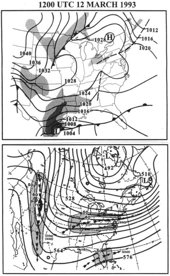
Figure 2 (a) Sea-level pressure (solid, interval of 4 hPa) for 1200 UTC, March 12, 1993.
(b) Heights (solid, interval of 6 dam) for 1200 UTC, March 12, 1993. (From Kocin et al.,
1995; reprinted by permission of AMS.)
546
WINTER WEATHER SYSTEMS
An extreme example of North American cyclogenesis occurred in March 1993.
The stage was set with a cold-air outbreak covering most of eastern North America
southward into the Gulf of Mexico (Fig. 2a). Rapid cyclogenesis in the Gul f of
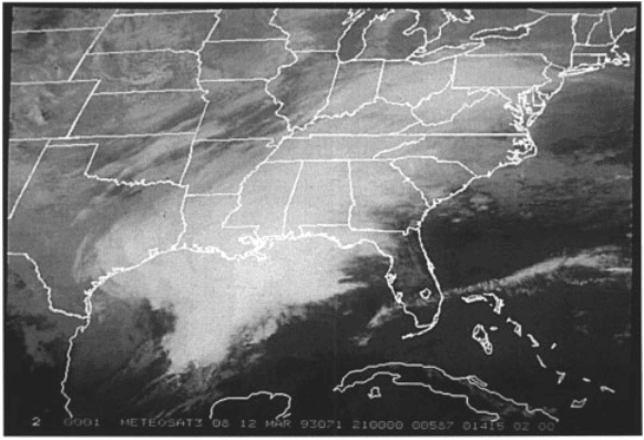
Mexico occurred in response to multiple interactions with upper-tropospheric mobile
troughs approaching from the west and northwest (Figs. 2b and 3). Additional
intensification was associated with the latent heat release in embedded thunder-
storms. Explosive intensification of 30 hPa during the next 24 h produced an unpre-
cedented 968-hPa cyclone in central Georgia by 1200 Universal Time Coordinated
(UTC), March 13 (Fig. 4a). At this time, the unusually large horizontal scale of the
cyclonic circulation extended from the Caribbean Sea northward into New England
and westward to the Mississippi River. The system continued to deepen to its
minimum pressure of 962 hPa during the next 12 h, in a favorable location for
interactions with the upper trough (Fig. 4b).
This Storm of the Century produced record low pressures at several locations
along the North American coast, blizzard conditions to the north and west of its
track, and a storm surge, comparable to that seen in hurricanes, along the Gulf of
Mexico coast of 3 to 4 m. Its development was triggered by multiple troughs aloft,
but the influence of topography was also substantial. First, the presence of the
anomalously warm Gulf of Mexico in association with a cold-air outbreak destabi-
lized the air. This destabilization enhanced the cyclogenesis by enhancing the inter-
actions with upper-level troughs. Second, the warming and moistening of the air
mass provided a favorable environment for the heavy thunderstor m activity occur-
ring near the cyclone center. This enhanced thunderstorm activity aided the cyclo-
genesis through the addition of latent heat of condensation.
Figure 3 Infrared satellite image for 2100 UTC, March 12, 1993.
3 WIND 547
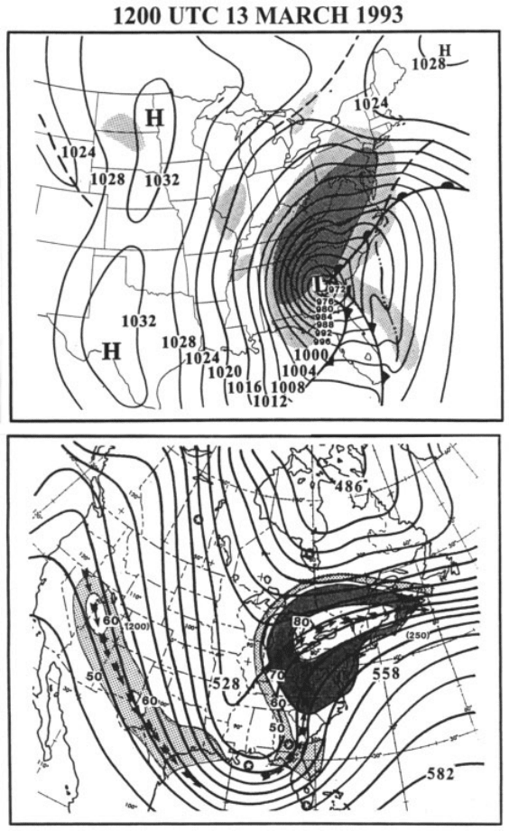
Figure 4 As for Fig. 2, except for 1200 UTC, March 13, 1993. (From Kocin et al., 1995;
reprinted by permission of AMS).
548
WINTER WEATHER SYSTEMS
Strong winds also can occur during the cold season in the lee of mountain ranges.
These wind storms, typically termed chinook winds, may contain hurricane-force
wind speeds and produce extensive property damage. Klemp and Lilly (1975)
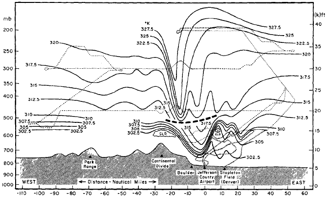
studied a case that occurred in Boulder, Colorado, in which the phenomenon is
found to be the surface signal of a standing g ravity wave with a wavelength of
60 km and an upwind tem perature inversion approximately 60 hPa above the
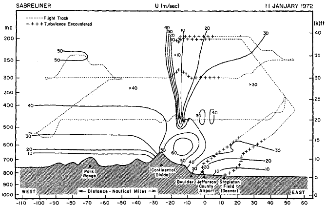
Continental Divide (Fig. 5). This extreme event was associated with surface wind
gusts of 50 m=s and extensive property damage. The vertical cross section of wind
speeds (Fig. 6) shows the core of extreme wind located 20 km to the east of the
Divide. Generally, similar events with gusts in excess of hurricane force occur each
winter. Such events occur when the westerlies are strong, the inversion above the
mountains is also strong, and in the lee of where the westerlies arrive at the Divide
unimpeded by upstream mountains.
4 PRECIPITATION
One of the more common synoptic-scale structures associated with cold-season
precipitation along the west coast of North America is the so-called pineapple
express. The synoptic-scale structure o f this event is similar to that observed for
most substantive cold-season rainfall events along the west coast of North America.
Figure 5 Cross section of potential temperature (K) along an east–west line through
Boulder, as obtained from analysis of aircraft data on January 11, 1972. The isentropes are
excellent indicators of streamlines for steady, adiabatic flow. Flight tracks are indicated by
light dashed lines, with the heavy dashed line separating the tracks of the different research
aircraft. (From Klemp and Lilly, 1975; reprinted by permission of AMS).
4 PRECIPITATION 549
The dominant lifting mechanism is the effect of cyclonic thermal vorticity advection,
in addition to anomalously large precipitable water amounts. Large amounts of water
vapor are transpor ted into the region from subtropica l maritime regions near Hawaii
by anomalously strong southwesterly tropospheric flow. These events can produce
large amounts of precipitation, induce flooding and landslides, and generally
produce great economic damage.
The meteorological effects of the pineapple express are amplified by the existence
of the north–south oriented mountain ranges that exist along the west coastal regions
of North America. The orographic lifting and cooling of the eastward-traveling
moisture-laden subtropical air enhances the precipitation rates on the windward
slopes of these mountains. The largest measured seasonal snowfalls in the world
occur in these areas. Washington State’s Paradise Ranger Station, at 1654 m on
Mount Rainier in the Cascades, averages 1733 cm (682.4 in.) of snowfall each
year. The Mount Baker ski resort, at 1286 m in the north Cascades of Washington,
recorded a single-season total snowfall of 2896 cm (1140 in.) during 1998–1999,
establishing a new world record [previously held by Paradise Ranger Station with
2850 cm (1122 in.) during 1971–1972].
The leeward regions to the east of the Cas cades, in contrast, receive relatively
small amounts of precipitation. This rain shadow effect is due to the compressional
warming of the easterly traveling air as it subsides on the lee slopes of the moun-
tains. A comparison of annual precipitation amounts illustrates this effect. Tacoma,
Washington, at an elevation of 89 m, receives 939.8 mm (37.0 in.), whereas Coulee
Figure 6 Horizontal velocity (m=s) contours along the cross section as in Fig. 5 and derived
from research aircraft obser vations. (From Klemp and Lilly, 1975; reprinted by permission of
AMS).
550
WINTER WEATHER SYSTEMS
Dam, to the east of the Cascades at an elevation of 518 m, receives only 274.3 mm
(10.8 in.).
An example of the synoptic pattern relating to events in western Washington and
Oregon is shown in Fig. 7 (Lackmann and Gyakum, 1999). The 46-case composite
corresponds to days in which at least 12.5 mm of precipitation falls on each of the
four stations shown in Fig. 7d, and in which the maximum temperature exceeded
10
C for each of the lowland stations and 5
C for Stampede Pass. The southwesterly
geostrophic flow in the region of the precipitation exists from the surface to 500 hPa.
The composite surface low in the Gulf of Alaska has an upper-level counterpart with
a planetary-scale trough that extends throughout the Pacific Ocean. Figure 8 shows
anomalously strong 500-hPa southwesterly flow prior, during, and after the event.
This strong flow extends from the subtropical regions of the Pacific to Oregon,
Washington, and British Columbia.
An extreme case of heavy rains along the western Nor th American coast in late
1996 was par t of a 2-week regime in which 250 to 1000 mm of rain fell, with
economic damage of up to $3 billion. The large-scale SLP and 1000–500-hPa
layer mean temperature fields for 1200 UTC, December 31, 1996 (Fig. 9), appear
very similar to those shown in Figure 7, with a deep planetary-scale trough covering
much of the south-central North Pacific Basin. The coldest tropospheric anomaly
corresponds to the stratospheric intrusion of high-PV (potential vorticity) air seen as
the dark region extending southwestward from the comma cloud of Figure 10. This
long plume of large PV provides forcing for the 960-hPa surfa ce cyclone seen in
Figure 9. As pointed out by Lackmann and Gyakum (1999), these cyclonic distur-
bances are responsible for transporting the subtropical water vapor from marine
areas near Hawaii directly toward the west coast of North America.
Snowfall may occur in ascending regions of surface cyclones and regions of
frontogenesis. However, especially large snows are strongly affected by topography.
One example o f such a strong topographic influence on snowfall is that of the lake
effect snowfalls. The most prominent region of North America that is affected by
these snowfalls is that of the Great Lakes. However, any comparably large body of
water in extratropical latitudes exerts a similar influence on the surrounding region.
The Great Salt Lake in Utah and James Bay in Quebec are two other examples of
North American lake effect regions.
Figure 11, derived from Eichenlaub’s (1979) work and in turn printed in the
review article by Niziol et al. (1995), shows the mean annual snowfall climatology
for the Great Lakes. The amounts vary from less than 50 cm in the southern region to
nearly 500 cm in regions east and south of Lake Superior. The existence of both the
Great Lakes and orography controls the variability of these climatological snowfalls.
The lake effect snowfall of December 17–19, 1985, which affected the Buffalo, New
York, area, was typical of the associated large-scale conditions. The environment
was characterized by a deep surface cyclone that traveled well to the north and east
of the affected region (Fig. 12), in this case a 968-hPa low located between Green-
land and Labrador. This low, combined with a 1040 surface anticyclone over the
Dakotas, advected bitterly cold air directly over the Great Lakes. The 1000–500-hPa
mean temperature over Lakes Superior, Michigan, and Huron was about 20
C colder
4 PRECIPITATION 551
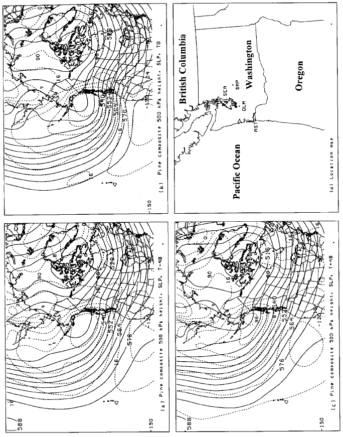
Figure 7 Pineapple Express composite of 500-hPa height (solid, interval of 6 dam) and sea-level pressure (dashed,
interval of 4 hPa) of 46 cold-season cases for (a) 48 h prior, (b) the day of, and (c) 48 h after the event. Geographical
references are displayed in (d), including Astoria, OR (AST); Olympia, WA (OLM); Seattle-Tacoma airport, WA (SEA);
and Stampede Pass, WA (SMP). (From Lackmann and Gyakum, 1999; reprinted by permission of AMS.)
552
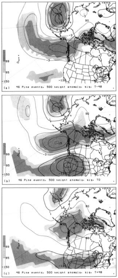
Figure 8 Composite 500-hPa geopotential height anomaly [contour interval 3 dam, positive
(negative) values solid (dashed), zero contour omitted] and statistical significance determined
from a two-sided Student’s t-test (shading intervals correspond to 95 and 99% confidence
limits as shown in legend at left of panels): (a) 48 h prior, (b) the day of, and (c) 48 h after the
event. The light (dark) shading denotes regions where there exists a greater than 95% (99%)
probability that the composite belongs to a population distinct from that of climatology. (From
Lackmann and Gyakum, 1999; reprinted by permission of AMS).
4 PRECIPITATION 553
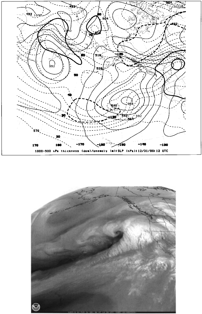
Figure 9 As for Fig. 1, except 1200 UTC, December 31, 1996.
Figure 10 Water vapor image for 1430 UTC, December 31, 1996. (Courtesy of NOAA).
554
WINTER WEATHER SYSTEMS
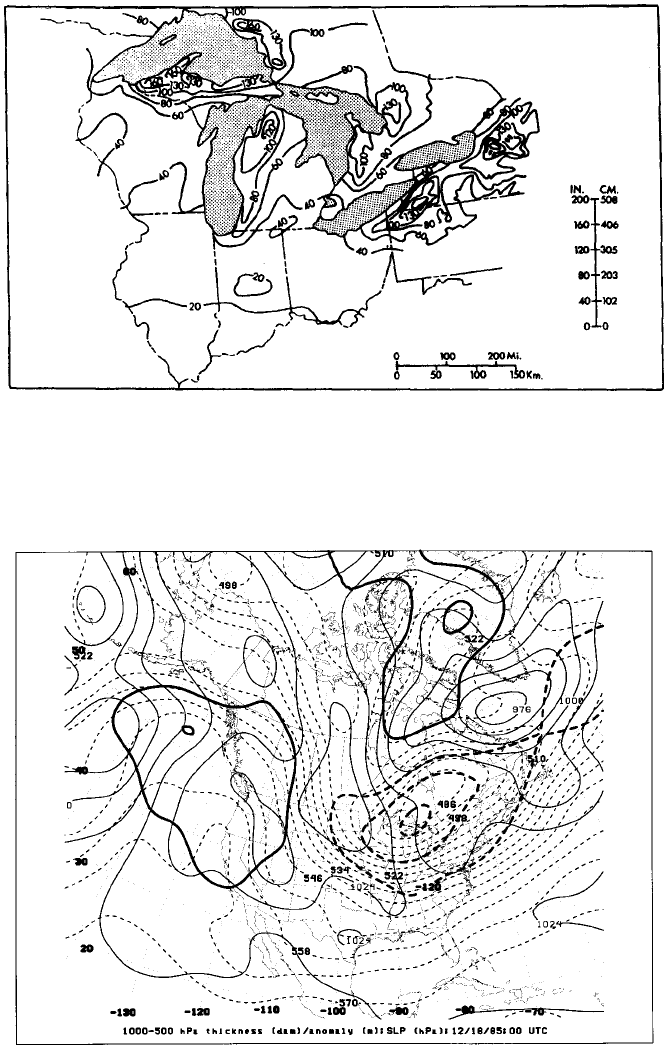
Figure 11 Mean annual snowfall (in.) for the Great Lakes region. (From Niziol et al., 1995;
in turn from Eichenlaub, 1979; reprinted by permission of AMS).
Figure 12 As for Fig. 1, except 0000 UTC, December 18, 1985.
4 PRECIPITATION 555
