Potter T.D., Colman B.R. (co-chief editors). The handbook of weather, climate, and water: dynamics, climate physical meteorology, weather systems, and measurements
Подождите немного. Документ загружается.

than the climatological average. The tropospheric air was about 12
C colder than the
mean in Buffalo. Despite the fact that the most substantial synoptic-scale ascent
typically is located to the north and east of a developing surface low, owing to a
favorable combination of warm advection and cyclonic vorticity effects, extremely
large snowfall rates in excess of 5 cm=h were observed in the Buffalo area. Several
factors contributed to such an extreme snowfall rate. These include large-scale
ascent associated with a strong upper-level trough. Within this environment, several
crucial mesoscale conditions amplify the response to this advection. First, the cold
air traveling over the relatively warm waters will hydrostatically destabilize the air.
Second, the evaporation of water vapor from the lakes wi ll saturate the air, so that the
effective hydrostatic stability will be reduced even further.
Additional physical processes are respon sible for enhancing the snow. These
include the development of a surface trough (Fig. 12) that provides the larger-
scale ascent necessary to trigger moist convection in the presence of instability.
The existence of sensible heat transfer from the unfrozen lakes to the atmosphere
contributes to ascent. Additionally, the differential roughness between the lakes and
the surrounding land will creat e low-level convergence areas with accompanying
ascent. Often, as in the case of the December 17–19, 1985, event, mesoscale bands
of heavy snow will develop (Fig. 13), and a key forecast problem is to predict the
existence and movement of such band(s).
Freezing rain events can have devastating impacts on economic infrastructure.
The synoptic environment of freezi ng rain is characterize d typically by a surface
extratropical cyclone advecting warm, moist air above relat ively shallow, cold air
masses. Areas that experience persistent shallow, cold air are therefore prone to
freezing rain. Especially susceptible regions include larger valleys and basins.
Cortinas (2000) has documented the mean synoptic conditions for freezing rain
events in the Great Lakes region. Figure 14 illustrates that freezing rain occurs to the
northeast of a surface cyclone that advects warm, moist air poleward from either the
Gulf of Mexico or the Atlantic Ocean. Typically, the air to the northeast of the low
had been associated with a prior cold-air outbreak. The temperature stratification
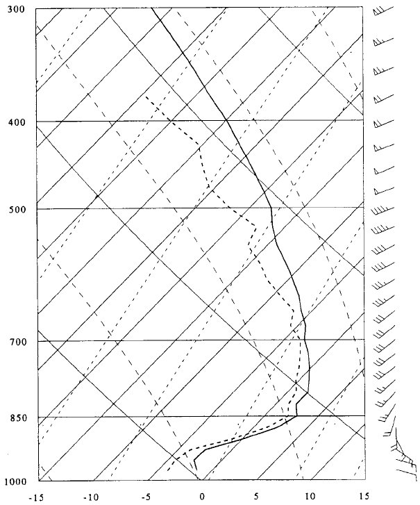
becomes very stable (Fig. 15), as the warm, moist air travels above the relatively cold
dense near-surface air. As Figure 15 shows, the lowest layer during a freezing rain
event is characterized by an inversion with near-surface air that is less than 0
C, with
a deep layer of air aloft that is greater than 0
C. The strong inversion helps to prevent
any turbulent mixing of the warm air aloft down to the surface. Furthermore, the
stratification decreases markedly above the inversion, to the extent that nearly moist
adiabatic conditions in the free atmosphere may exist. The implication for precipita-
tion amounts is that substantial ascent, or even convection, may occur in these upper
weakly stratified layers. The lowest-layer air is typically from the east or northeast,
and this reinforces the inversion with cold-temperature advection from the down-
shear polar air mass. The wi nds at the top of the inversion are typically warm and
moist and blowing from the southwest. Therefore the vertical wind shear reinforces
the temperature inversion.
An extreme example of such an event occurred during January 5–9, 1998, when
an ice storm deposited greater than 100 mm of predominantly freezing rain in south-
556 WINTER WEATHER SYSTEMS
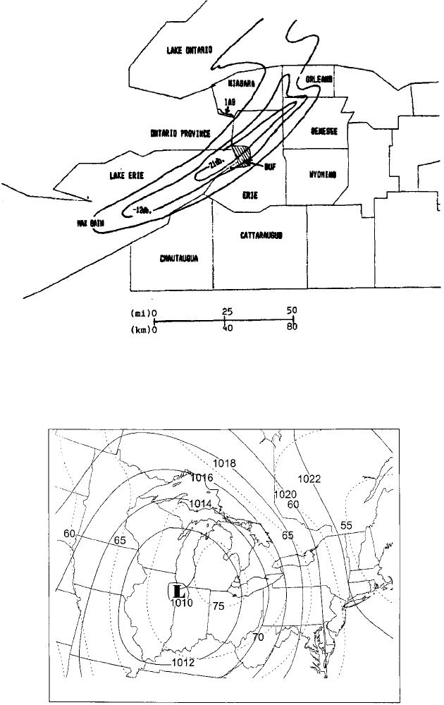
Figure 13 Precipitation echoes from the WSR-57 radar at Buffalo for the Lake Erie
snowstorm on 2330 UTC, December 17, 1985. Snowfall intensities are contoured for local
use, with linear attenuation, to depict the areas of heaviest snowfall more accurately. (From
Niziol, 1987; reprinted by permission of AMS).
Figure 14 Mean sea-level pressure (hPa, solid line) and 1000–666-hPa relative humidity
(%, dashed line) during freezing rain events over the central Great Lakes for the period
1976–1990. (From Cortinas, 2000; reprinted by permission of AMS).
4 PRECIPITATION 557
ern Quebec and upstate New York. Approximately 44 fatalities and damages in
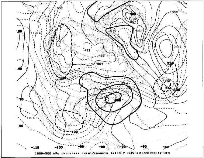
excess of $4 billion occurred (NOAA, 2000). The synoptic conditions at 1200
UTC, January, 8, 1998 (Fig. 16), were typical for the event. The freezing rain
occurred in a strong geostrophic deformation zone that extended northeast of a
surface low from upstate New York into New England. Surface temperatures
during the event ranged from 5to1
C in extremely large 1000–500-hPa thick-
nesses of 552 dam or greater. The anomalously strong Bermuda anticyclone assisted
Figure 15 Median values of dry-bulb temperature (
C, dark solid line) and dewpoint
temperature (
C, dark dashed line) from a distribution of freezing rain soundings at Flint,
Michigan. Data are plotted on a skew T–log p diagram, with pressure (vertical axis) given in
hPa and winds shown by full barb ¼5m=s and half barb ¼2.5 m=s. (From Cortinas, 2000;
reprinted by permission of AMS).
558
WINTER WEATHER SYSTEMS
the tropospheric warming of the affected regions with northward transports of warm
and moist air from the Caribbean Sea. Surface winds advected cold air from the
northeast along the Saint Lawrence River Valley. These surface winds occurred
along the southern flank of a bitterly cold 1044-hPa surface anticyclone centered
in the Canadian Northwest Territories. While the instantaneous synoptic-scale
features were unusually strong for a freezing rain event, the factor that produced
such an extreme event was the persistence for 5 days of this freezing rain–producing
pattern.
5 SUMMARY
We have discussed several meteorological phenomena associated with winter
weather. These events, associated with extreme cold, wind, and precipitation, have
the potential to produce substantial economic impact (NOAA, 2000). We have
described these events in terms of the larger-scale meteorological patterns that are
conducive to their existence. Additionally, we have seen how these events are
produced by the modulation of larger-scale atmospheric patterns by interesting
topographic features, such as mountains, lakes, and oceans. Although we have
focused our attention on North American phenomena, similar events exist in other
Figure 16 As for Fig. 1, except for 1200 UTC, January 8, 1998.
5 SUMMARY 559
regions of the world, where similar interactions exist between the atmospheric flows
and topography.
REFERENCES
Cortinas, J., Jr. (2000). A climatology of freezing rain in the Great Lakes region of North
America, Mon. Wea. Rev. 128, 3574–3588.
Eichenlaub, V. L. (1979). Weather and Climate of the Great Lakes Region, Notre Dame, IN,
University of Notre Dame Press.
Kalnay, E., M. Kanamitsu, R. Kistler, W. Collins, D. Deaven, L. Gandin, M. Iredell, S. Saha,
G. White, J. Woollen, Y. Zhu, A. Leetmaa, B. Reynolds, M. Chelliah, W. Ebisuzaki,
W. Higgins, J. Janowiak, K. C. Mo, C. Ropelewski, J. Wang, R. Jenne, and D. Joseph
(1996). The NCEP=NCAR 40-year reanalysis project, Bull. Am. Meteor. Soc. 77, 437–471.
Klemp, J. B., and D. K. Lilly (1975). The dynamics of wave-induced downslope winds,
J. Atmos. Sci. 32, 320–339.
Kocin, P. J., P. N. Schumacher, R. F. Morales, Jr., and L. W. Uccellini (1995). Overview of the
12–14 March 1993 superstorm, Bull. Am. Meteor. Soc. 76, 165–182.
Lackmann, G. M., and J. R. Gyakum (1999). Heavy cold-season precipitation in the north-
western United States: Synoptic climatology and an analysis of the flood of 17–18 January
1986, Wea. Forecasting 14, 687–700.
NOAA (2000). Billion Dollar US. Weather Disasters, 1980–2000 (available on the World Wide
Web at http:==www.ncdc.noaa.gov=ol=reports=billionz.html).
Niziol, T. A. (1987). Operational forecasting of lake effect snowfall in western and central
New York, Wea. Forecasting 2, 310–321.
Niziol, T. A., W. R. Snyder, and J. S. Waldstreicher (1995). Winter weather forecasting
throughout the Eastern United States. Part IV: Lake effect snow, Wea. Forecasting 10,
61–77.
Quiroz, R. S. (1984). The climate of the 1983–84 winter—a season of strong blocking and
severe cold in North America, Mon. Wea. Rev. 112, 1894–1912.
560
WINTER WEATHER SYSTEMS

CHAPTER 28
TERRAIN-FORCED MESOSCALE
CIRCULATIONS
JOHN HOREL
1 INTRODUCTION
The characteristics of the Earth’s surface affect climate and weather on all spatial
scales (Barry, 1992). However, many weather phenomena that are influenced by
surface inhomogeneities in elevation, moisture, temperature, snow cover, vegetation,
or roughness are organized on the mesoscale, which spans the range from 2 to
200 km. According to Pielke (1984), weather systems on the mesoscale can be
divided into two general categories: those that are forced primarily by instabil ities
in traveling large-scale disturbances (e.g., squall lines or mesoscale convective
complexes) and those that are forced by surface inhomogeneities (e.g., mountain=
valley circulations, sea breezes, or urban circulations).
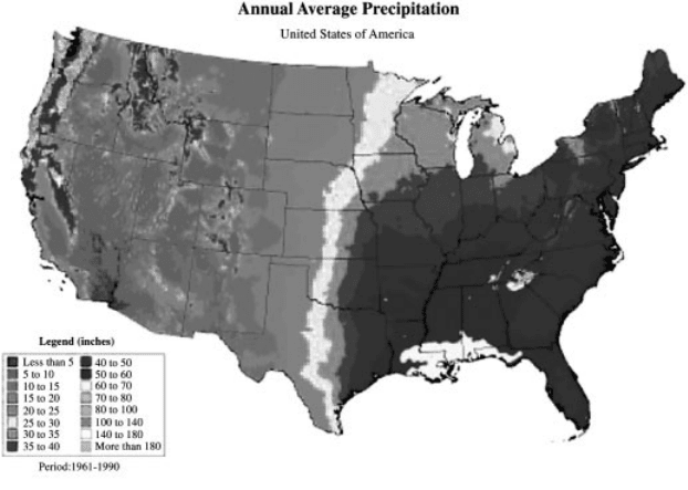
The impact of mesoscale variations in the underlying land surface is evident in an
estimate of the average annual precipitation over the United States (Fig. 1). As a
general rule, precipitation increases locally as terrain height increases, for example
over the Appalachians and the mountain ranges of the western United States.
A further general rule is that precipitation is higher near the coasts, where moisture
is more abundant, than further inland.
This section emphasizes mesoscale weather phenomena that are strongly modu-
lated by the characteristics of the underlying surface. After discussion of thermally
driven and mechanically driven flows, the impact of terrain upon precipitation
processes will be presented. The influence of other variations in surface properties
Handbook of Weather, Climate, and Water: Dynamics, Climate, Physical Meteorology, Weather Systems,
and Measurements, Edited by Thomas D. Potter and Bradley R. Colman.
ISBN 0-471-21490-6 # 2003 John Wiley & Sons, Inc.
561
upon mesoscale circulations is followed by discussion of the predictability of
terrain-forced mesoscale circulations.
2 IMPACT OF TERRAIN UPON WIND
Thermally Driven Flows
Mesoscale wind circulations are produced frequently by temperature contrasts that
develop as a result of terrain variations. As noted by Pielke and Segal (1986) , the
general nature of diurnal sea and land breezes was well understood in ancient times:
‘‘southward goes the wind, then turns to the north; it turns and turns again’’ (Eccle-
siastes 1:6). Sea (or lake) and land breezes are driven by horizontal tem perature
contrasts that develop between water bodies and adjacent land surfaces (Whiteman,
2000). As shown in Figure 2 for the Great Salt Lake (the largest body of water in the
continental United States to the west of the Great Lakes), differences in air tempera-
ture develop over the water and land surfaces as a result of the higher heat capacity
of the water relative to that of the surrounding land. In the case of the Great Salt
Lake during summer, the air over the lake is roughly 1
C warmer than the air over
the surrounding land at night and 4
C cooler during the day. These temperature
Figure 1 (see color insert) Average annual precipitation in inches, as determined from the
Parameter-elevation Regression on Independent Slopes (PRISM) model by Chris Daly, based
on 1961–1990 normals from National Oceanic and Atmospheric Administration (NOAA)
cooperative stations and Natural Resources Conservation Service (NRCS) SNOwpack
TELemetry (SNOTEL) sites. Modeling sponsored by USDA-NRCS Water and Climate
Center, Portland, Oregon. Available from George Taylor, Oregon State Climatologist,
Oregon Climate Service. See ftp site for color image.
562
TERRAIN-FORCED MESOSCALE CIRCULATIONS
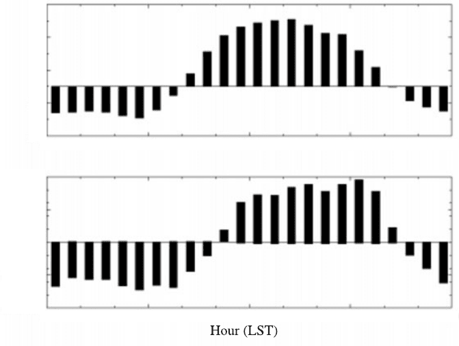
differences drive the air from over the water to over the land during the day (lake
breeze) and drive the air from over the land to over the water at night (land breeze).
The resulting convergence of the surface winds at night over the Great Salt Lake and
divergence during the day are evident in Figure 2.
Mountain–valley circulations arise as a result of differential heating between the
ground in regions of complex terrain and the free atmosphere at the same elevation.
There are two broad categories for mountain–valley circulations: slope flows and
along-valley winds (Whiteman, 1990, 2000). Typically, slope flows are driven by
horizontal temperature contrasts between the air over the valley sidewalls and the air
over the center of the valley. Since a larger diurnal temperature variation occurs near
the ground, the higher terrain above the valley serves as a heat source during the day
and a heat sink at night. These temperature differences between the slope and free air
over the valley drive cold, dense air flowing down the slope at night and warm, light
air surging up the slope during the day. Upslope flows tend to be deeper than
the shallow nocturnal drainage flows as a result of strong turbulent mixing during
the day.
3
5
1
–1
–3
0.0 6.0
12.0 18.0 0.0
0.0 6.0 12.0 18.0 0.0
1.0e–04
5.0e–05
0.0e–00
–5.0e–05
–1.0e–04
Figure 2 Top panel: Diurnal variation in the difference in air temperature (
C) over the land
surrounding the Great Salt Lake, Utah, versus the air over the lake during August 1999. The
air over the lake is warmer than the air over the land during the night. Bottom panel: Diurnal
variation in surface wind divergence (s
1
) over the Great Salt Lake. The air converges over the
lake at night and diverges away from the lake during the day (a similar diurnal variation in
surface wind divergence is evident over Lake Ontario; Chen, 1977).
2 IMPACT OF TERRAIN UPON WIND 563
Along-valley winds develop as a result of variations in the strength of slope flows
within the valley or differences in temperature between the air in the valley and that
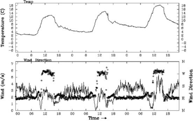
found over the adjacent lowlands. As an example of along-valley circulations,
Figure 3 shows the evolution of wind and temperature at a station located roughly
midway along the length of the Big Cottonwood Canyon in the Wasatch Mountains
of northern Utah. During this 3-day period, a warming trend was underway and the
skies remained clear; further, the station location within this narrow, steep canyon
was shaded during the morning and late afternoon. The diurnal temperature swing of
roughly 10
C drove a reversal in the wind from downvalley at night (from the east)
to upvalley during the day (from the west). The sudden onsets of the wind reversals
were particu larly striking during these 3 days.
Dynamically Driven Flows
As summarized by Whiteman (2000), the degree to which a hill or mountain affects
the air flow depends upon the characteristics of the terrain feature (e.g., height,
width, roughness, orientation relative to flow direction) and the upstream speed
and stability of the air. Since the speed and stability of the flow can vary significantly
with height, the impact of the terrain upon the flow can change from one
atmospheric layer to another (Fig. 4).
Figure 3 Diurnal mountain–valley circulation in Big Cottonwood canyon in the Wasatch
Mountains of northern Utah. Top panel: temperature (
C) from midnight local standard time
(LST) October 15 to midnight October 18, 2000. Bottom panel: wind speed (solid line in m=s)
and wind direction (circles) for the same period. The weather station is located where the
canyon is oriented east–west.
564
TERRAIN-FORCED MESOSCALE CIRCULATIONS
Whether an obstacle significantly obstructs the flow depends upon whether or
not the approaching air has enough kinetic energy to lift the air over it. The non-
dimensional Froude number (defined as Fr ¼u=Nh, where u is the speed of the
upstream flow, N is the Brunt–Vaisala frequency, a measure of stability, and h is
the height of the terrain) provides a conceptual framework to assess the impact of
terrain height and flow speed and stability. If the flow approaching a relatively low
obstacle has strong winds and weak stability (Froude number greater than 1), then
there is sufficient kinetic energy to cross the obstacle. On the other hand, if the flow
approaches a relatively high barrier with weak winds and strong stability (Froude
number less than 1), then there is not enough kinetic energy to force the air over the
obstacle and the flow is either channeled through gaps in the terrain or forced to
travel laterally around the obstacle. For example, Figure 5 shows fog spilling through
a gap in the coastal mountains of northern California as a result of strong stability at
crest level. The flow is more likely to be blocked and required to travel around
obstacles if the barrier has a relatively short lateral extent or the flow impinging upon
the mountain range is very shallow.
As stable air flows across a mountain barrier (with Froude number less than 1),
mountain gravity waves are often created over or in the lee of the barrier (Durran,
1990). The structure of the mountain waves exhibited at any particular time depends
upon the charateristics of the barrier (e.g., height, width, mul tiple ridges) as well as
the stability, orientation of the flow relative to the ridge crest, and vertical change of
wind with height. If sufficient moisture is present, the uppermost portion of the wave
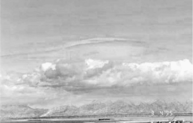
Figure 4 (see color insert) Cumulus clouds, indicative of shallow instability, above the
Wasatch Mountains in northern Utah are capped by lenticular wave clouds, indicative of stable
air flowing across the mountain barrier (photo by J. Horel). See ftp site for color image.
2 IMPACT OF TERRAIN UPON WIND 565
