Potter T.D., Colman B.R. (co-chief editors). The handbook of weather, climate, and water: dynamics, climate physical meteorology, weather systems, and measurements
Подождите немного. Документ загружается.

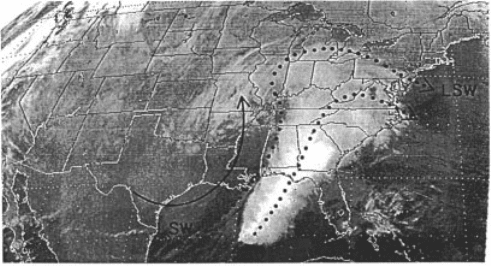
of high cloud with a sharp western edge. This cloud band represents the so-called
warm conveyor belt, within which air from relatively warm latitudes is carried
northward and upward through the storm roughly parallel to the cold front before
curving anticyclonically beyond the warm front (Fig. 11). Precipitation beneath this
conveyor belt may be convective, stratiform, or nonexistent. If the cyclone is suffi-
ciently strong, the conveyor belt cloud band may curve cyclonically around the
approximate position of the low center (as in Fig. 7b), or a separate cloud mass
known as the cold conveyor belt may be present (as in Fig. 8b over the Dakotas and
Fig. 10b over the Great Lakes and upper Midwest). This conveyor belt consists of air
originating north of the warm front and ascending ahead of and on the poleward side
of the cyclone before spreading northward or wrapping around the cyclone center. A
third upper-tropospheric airstream, consi sting of air descending behind the cyclone
and curving cyclonically to the nor theast, is known as the dry airstream and is
indicated in Figure 11.
These cloud structures may be used to diagnose the location and intensity of the
extratropical cyclone center, but they are most directly related to the horizontal and
vertical wind fields in the upper troposphere and the distribution of precipitation.
Because surface pressure features tend to be strongly modified by orography, the
structure of the surface cyclone can be inferred reliably from cloud structures only
over water. Notice the superficial similarity of Figures 7 b ,8b, and 10b despite the
wildly different low-level wind and pressure fields.
Statistical Climatology
The climatological distribution of extratropical cyclones reflects the influence of
orography (Fig. 12). Cyclones are most common over the oceans between latitudes
of 30
N and 60
N. In contrast, extratropical cyclones are rare over high orography.
Figure 11 Infrared satellite images showing the location of the warm conveyor belt (dotted
streamlines) and the dry airstream (solid streamline). ‘‘LSW’’ marks the leftmost streamline in
the warm conveyor belt, which is known as the ‘‘limiting streamline’’ and typically is
manifested as a sharp cloud boundary in satellite imagery. (From Carlson, 1991).
526
LARGE-SCALE ATMOSPHERIC SYSTEMS
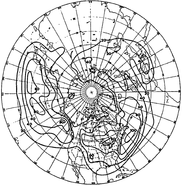
Given the general tendency of cyclones to move toward the east or northeast, one can
infer from Figure 12 the general distribution of cyclogenesis (formation and inten-
sification of extratropical cyclones) and cyclolysis (weakening and dissipation of
extratropical cyclones). Cyclones tend to form downstream of major mountain
barriers such as the Rocky Mountains and the Alps, as well as over the midlatitude
oceans. Semipermanent large-scale cyclones may be found in the extreme North
Atlantic (the Icelandic low) and North Pacific (the Aleutian low). These lows are
periodically reinvigorated as strong extratropical cyclones migrate northwestward
across the jet and merge with them. At higher latitudes, small-scale intense extra-
tropical cyclones known as polar lows sometimes form near the sea ice boundary.
These polar lows are partly driven by deep convection as air masses are destabilized
by the underlying warmer ocean surface, and share some of the characteristics of
hurricanes.
The midlatitude extratropical cyclones that become particularly intense typically
do so by deepening rapidly. Such explosively deepening cyclones, known a s bombs,
Figure 12 Distribution of total number of cyclones passing through 5 5 latitude–longitude
boxes during 20 Januarys, 1958–1977. (From Whittaker and Horn, 1984).
6 EXTRATROPICAL CYCLONES 527
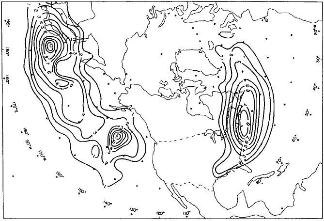
develop almost exclusively over the oceans, preferentially near the eastern edge of
continents (Fig. 13). Conditions favoring explosive deepening include a strong
upper-level disturbance, a strong low-level horizontal temperature gradient, and a
source of warm, moist air. The Kuroshio current (in the Pacific) and the Gulf Stream
(in the Atlantic) help provide the latter two conditions by influencing the distribution
of heat and moisture in the overlying atmosphere.
Vertical Structure and Dynamics of Extratropical Cyclones
For development, extratropical cyclones require vertical shear. This means that
cyclones will typically develop beneath an upper-tropospheric jet stream. Since
balanced vertical shear implies a horizontal temperature gradient, cyclones therefore
develop withi n a large-scale temperature gradient or along a frontal zone. Discussing
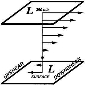
the vertical structure of extratropical cyclones requires the introduction of the terms
upshear, meaning in the direction opposite the vertical shear vector (typically, the
direction opposite the upper-tropospheric jet stream), and downshear, meaning in the
same direction as the vertical shear vector (typically, downwind relative to the upper
troposphere). These concepts are illustrated in Figure 14.
Figure 13 Distribution of the locations at which rapidly deepening extratropical cyclones
undergo their most rapid intensification, expressed as total number within each
5 5 latitude–longitude box (normalized by latitude) for the period 1976–1982. (From
Roebber, 1984).
528
LARGE-SCALE ATMOSPHERIC SYSTEMS
An intensifying extratropical cyclone, as defined by the height and pressure
distribution, typically tilts upshear with height. This means that the trough in the
upper troposphere will be located upshear of the surface cyclone. The temperat ure
distribution is tilted in the opposite sense, so that the warmest temperatures at the
surface are just downshear of the surface cyclone position and the warmest tempera-
tures in the upper troposphere are well downshear of the surface cyclone position.
The largest variations in pressure and temperature are located in the upper tropo-
sphere and at the surface but are substantial at all levels in between. This pressure
and temperature distribution is entirely consistent with thermal wind balance, so this
particular pressure distribution implies this particular temperature distribution and
vice versa. Winds, being in approximate geostrophic balance, vary in tandem with
pressure.
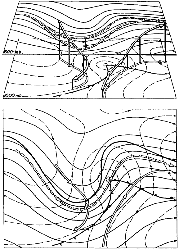
The vertical motion is an integral part of the extratropical cyclone structure
because without vertical motion cyclones would not intensify. Cyclone intensifica-
tion can be thought of a s an increase in the circulation about the cyclone center and,
for large-scale frictionless flow, the fractional rate of increase of total circulation
(including the circulation associated with Earth’s rotation, which is essentially
constant) is proportional to the horizontal convergence of the wind. Mass conserva-
tion implies upward motion in the middle troposphere wherever there is low-level
convergence (excluding exotic effects associated with a sloping lower boundary), so
vertical motion is not just a consequence of cyclogenesis; it is a necessary compo -
nent of cyclogenesis. Since the stratosphere inhibits vertical motion, upper-
tropospheric convergence (and intensification of the upper-tropospheric part of the
cyclone) implies midtropospheric downward motion. In a typical intensifying
cyclone, there is midtropospheric upward motion (with the associated clouds and
precipitation) ahead of and over the surface cyclone, and downward motion beneath
and behind the upper-tropospheric troug h (Fig. 15).
Figure 14 Schematic showing the definition of upshear and downshear for a simple, typical
vertical distribution of horizontal wind. The low-pressure system in the figure tilts upshear
with height.
6 EXTRATROPICAL CYCLONES 529
To diagnose and predict extratropical cyclogenesis, meteorologists use a relation-
ship between the structure of the large-scale balanced winds and temperatures and
the vertical motion known as the omega equation. The omega equation is a three-
dimensional analog to the Sawyer–Eliassen equation and is based on the same
Figure 15 Distribution of upward and downward motion in an idealized extratropical
cyclone. Depicted are a perspective view (top) and two-dimensional view (bottom) of
height contours at 1000 mb (dashed) and 600 mb (thin solid), surface fronts, and ascending
and descending airstreams (wide arrows) with their projections onto the 1000-mb or 600-mb
surfaces. (From Palmen and Newton, 1969).
530
LARGE-SCALE ATMOSPHERIC SYSTEMS
dynamical principles of continuous adjustment to preserve nearly balanced flow. The
forcing, the wind and temperature patterns that imply upward motion, is rather
complicated when expressed mathematically, and several versions of the equation,
some involving simplifying assumptions, are in use. The most common qualitative
application roughly equates upward motion with the sum of two terms, one propor-
tional to the vertical derivative of vorticity advection and the other proportional to
the temperature advection. The first term tends to dominate in the upper troposphere
and implies upward motion ahead of an upper-level trough and downward motion
behind it. The second term tends to dominate in the lower troposphere and implies
upward motion ahead of the surface cyclone (where warm advection is typically
found) and downward motion behind it. Between the upper-level trough and the
surface cyclone, it will be noted that the two terms are of opposite sign, leading to
difficulty in inferring the vertical motion field there using this method. With the
increasing use of computers, many of these simplifying assumptions are being
discarded in favor of explicit mathematical calculation of the vertical motion forcing,
but the qualitative interpretation is still essential for relating the vertical motion field
to the large-scale features in the lower and upper troposphere.
In contrast to the simultaneous treatment of winds, temperatures, and vertical
motion, cyclogenesis can also be understood from a dynamical point of view in
terms of potential vorticity. Indeed, the basic theoretical paradigm for cyclogenesis,
known as baroclinic instability, requires a potential vorticity gradient aloft opposite
in orientation to the surface potential temperature gradient as a necessary condition
for instability. Cyclogenesis itself, by any mechanism, requires an increase in the
integrated perturbation potential vorticity and=or surface perturbation potent ial
temperature in the vicinity of the surface cyclone. Baroclinic instability accom-
plishes this by having two waves exist simultaneously, one on the surface potential
temperature gradient and the other on the upper-tropospheric potential vorticity
gradient; if the two waves are of large enough horizontal scale and the upper one
is upshear of the lower one, the circulation associated with each wave causes the
other wave to intensify. Other mechanisms for growth that do not involve instability
include rearrangement (specifically, compaction) of potential vorticity by horizontal
shear, and a decrease in the vertical tilt between the upper and lower perturbations.
Using the electrostatics analogy, the instability mechanism involves increasing the
electric charge, while the other two mechanisms involve rearranging the electric
charge into a compact area. The potential vorticity approach and the omega equation
approach are mutually consistent and complementary.
7 UPPER-TROPOSPHERIC JETS AND TROUGHS
A meteorologist looks at the surface weather map to see the current weather but
looks at an upper-tropospheric map to understand the current weather. The up per-
tropospheric map, generally the 500-mb constant-pressure surface or above, shows
the meteorologist the upper-level featu res associated with the current vertical motion
7 UPPER-TROPOSPHERIC JETS AND TROUGHS 531
field, the current motion of the upper-level features and related surface features, and
the potential for intensification of surface cyclones and anticyclones. By examining
the large-scale height fie ld at or near jet stream level, the meteorologist can infer the
likely distribution of surface temperatures and the likely path of any storms that
might develop.
Jet Streams and Jet Streaks
The jet stream is often described as a band of strong winds in the upper troposphere
(8 to 12 km above sea level) encircling the globe. Typically, however, the location of
the jet stream is not so simple. There may be two or more jet streams at a given
longitude, or the Northern Hemisphere jet stream may originate in the subtropical
Atlantic, cross southern Asia, pass over the Pacific Ocean at about 35
N and the
Atlantic at 45
N, and eventually weaken over northern Asia. Three examples of the
wintertime Northern Hemisphere jet stream and one of the wintertime Southern
Hemisphere jet stream are shown in Figure 16.
The first example (Fig. 16a) possesses many features common to the Northern
Hemisphere wintertime circulation. The strongest jet is over the Pacific Ocean,
although it is unusually far south in this example. Consistent with this departure
from normal is an unusual northward displacement of the jet over North America;
long-term departures from the average circulation tend to have wavelengths of about
8000 km. Over the Atlantic Ocean and over Asia there are at least two jets. The
southern jet is called the subtropical jet and the northern jet is called the polar jet.
The second example (Fig. 16b) is unusual because the jet over the Atlantic is
stronger than the jet over the Pacific. This unusually strong Atlantic jet corresponds
to a location where the polar and subtropical jet streams appear to merge. Over the
extreme northeastern Atlantic and northern Europe is a northward displacement of
the jet stream known as a block, because weather disturbanc es are carried northward
around the block rather than from west to east as would be normal. This particular
block is known as an omega block because of the resemblance of the jet stream
pattern to the Greek letter O.
The third example (Fig. 16c) occurred during an El Nin
˜
o year and is also quite
unusual. It features a subtropical jet that is essentially continuous around the globe,
with a weaker polar jet that is nearly continuous except for its merger with the
subtropical jet over the Pacific. Some resemblance may be found to the wintertime
jet pattern over the Souther n Hemisphere (Fig. 16d), which also features two nearly
continuous jets. As a general rule, because the topographic and sea surface tem pera-
ture variations in the Southern Hemisphere are comparatively small, the planetary-
scale waves in the jet stream tend to be weaker there. Also (not shown), the jet
streams actually tend to be stronger during the summer in the Southern Hemisphere
than during the winter because the pole-to-subtropics temperature contr ast increases
during the summer season. In the Northern Hemisphere, temperatures are much
more uniform during the summer and the upper-tropospher ic jet speeds are corre-
spondingly weaker.
532 LARGE-SCALE ATMOSPHERIC SYSTEMS
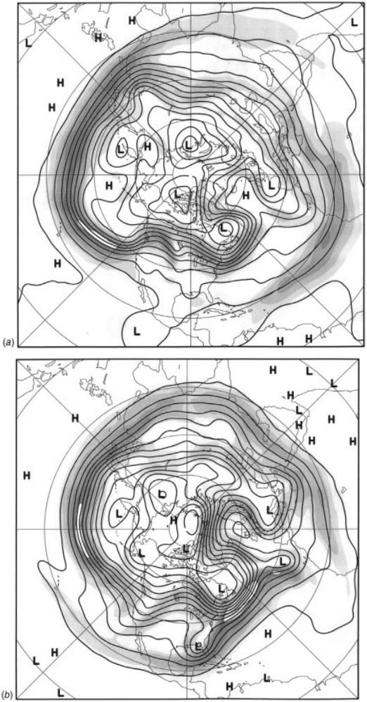
Figure 16 Wind speed (shaded, 10 m=s interval, beginning at 20 m=s) and height (solid,
120-m interval) at 250 mb for four wintertime hemispheres. (a) 0000 UTC Jan. 1, 1997. (b)
1200 UTC Dec. 15, 1997. (c) 0000 UTC Feb. 1, 1998. (d) 0000 UTC July 1, 1997.
7 UPPER-TROPOSPHERIC JETS AND TROUGHS 533
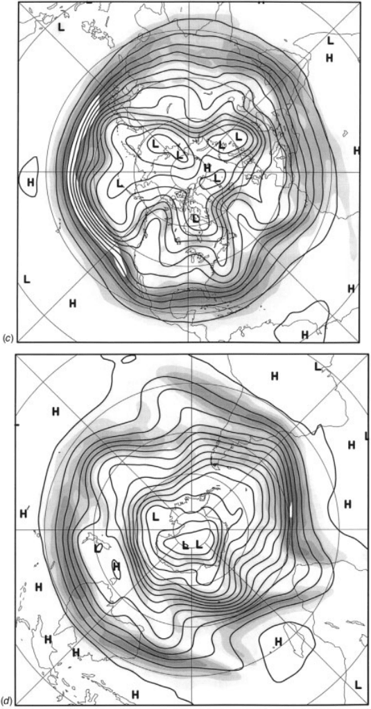
Figure 16 (continued )
534 LARGE-SCALE ATMOSPHERIC SYSTEMS
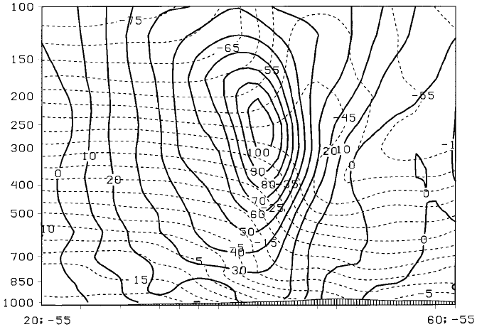
In a cross section through a jet stream (Fig. 17), the close relationship between the
horizontal derivative of tem perature and the vertical derivative of wind speed is
apparent. Beneath the jet is a strong horizontal temperature gradient, and the wind
speed increases with height; above the jet the opposite is true. At jet steam level, the
vertical derivative of wind speed is (by definition) zero and, to the extent that the
airflow is balanced, the horizontal derivative of temperature is zero too. The height of
the tropopause (marked by the transition between a rapid decrease of temperature
with height and nearly uniform temperatures with height) also varies across the jet
stream, being low on the poleward side and high on the equatorward side. Since
potential vorticity is much higher in the stratosphere than the troposphere, a strong
potential vorticity gradient would also be found in the vicinity of the jet.
A jet streak is essentially a local wind maximum within a jet stream. Being of
smaller scale than a jet stream, air parcels frequently undergo rapid accelerations as
they enter and exit a jet streak, implying strong ageostrophi c winds and the like-
lihood of patterns of divergence and convergence. For example, as an air parcel
enters a jet streak, it experiences a stronger pressure (or height) gradient than before,
and accelerates to its left in the direction of lower heights. This downgradient-
directed ageostrophic wind then implies a Coriolis force directed in the original
direction of motion, causing the air parcel to speed up and ultimately approach
balance with the height gradient. In terms of the ageostrophic wind, one expects a
Figure 17 Vertical section taken through the strong Atlantic jet shown in Fig. 16c along
55
W. South is to the left. Solid contours show the component of wind into the page (m=s) and
dashed contours show temperature (
C).
7 UPPER-TROPOSPHERIC JETS AND TROUGHS 535
