Potter T.D., Colman B.R. (co-chief editors). The handbook of weather, climate, and water: dynamics, climate physical meteorology, weather systems, and measurements
Подождите немного. Документ загружается.


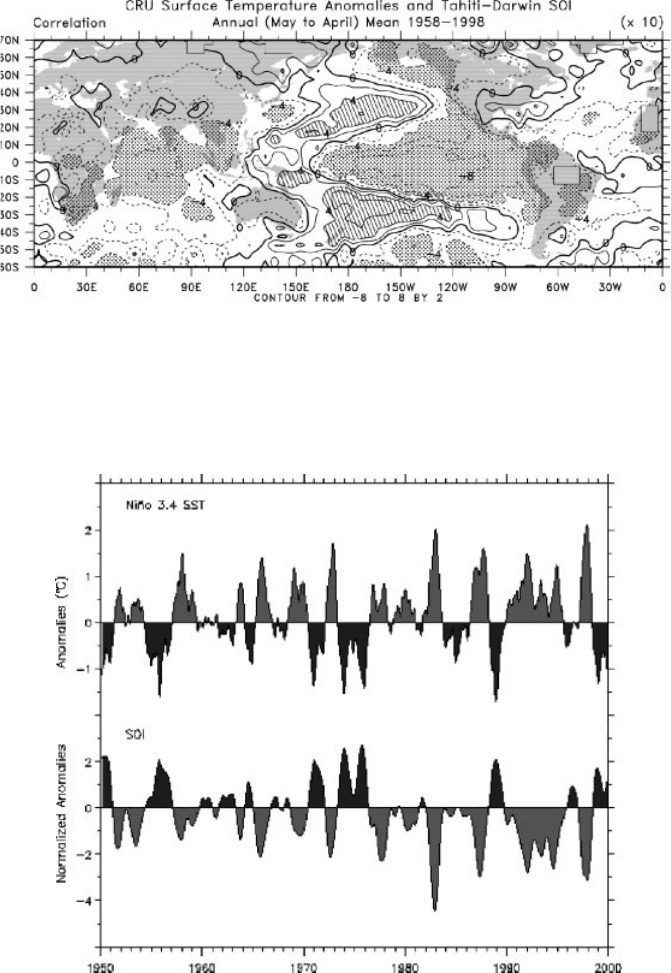
Figure 1 (see color insert) Correlation coefficients of the SOI with sea surface temperature
seasonal anomalies for Januar y 1958 to December 1998. It can be interpreted as the sea
surface temperature patterns that accompany a La Nin
˜
a event, or as an El Nin
˜
o event with
signs reversed. Values in the central tropical Pacific correspond to anomalies of about 1.5
C
[From Trenberth and Caron, 2000]. See ftp site for color image.
Figure 2 (see color insert) Time series of areas of sea surface temperature anomalies from
1950 through 2000 relative to the means of 1950–79 for the region most involved in ENSO 5
N–5
S, 170
E –120
W (top) and for the Southern Oscillation Index. El Nin
˜
o events are in
grey and La Nin
˜
a events in black. See ftp site for color image.
166
THE EL NIN
˜
O–SOUTHERN OSCILLATION (ENSO) SYSTEM

with less rainfall, while lower than normal pressures are identified with ‘‘bad’’
weather, more storminess, and rainfall. So it is with the SO. Thus for El Nin
˜
o
conditions, higher than normal pressures over Australia, Indonesia, southeast
Asia, and the Philippines signal drier conditions or even droughts. Dry conditions
also prevail at Hawaii, parts of Africa, and extend to the northeast part of Brazil and
Colombia. On the other end of the seesaw, excessive rains prevail over the central
and eastern Pacific, along the west coast of South America, parts of South America
near Uruguay, and southern parts of the United States in winter (Fig. 4). In the
winters of 1992–1993, 1994–1 995, and 1997–1998 this included excessive rains
in southern California, but in other years (e.g., 1986–1987 and 1987–1988 winters)
California is more at risk for droughts. Because of the enhanced activity in the
central Pacific and the changes in atmospheric circulation throughout the tropics,
there is a decrease in the number of tropical storms and hurricanes in the tropical
Atlantic during El Nin
˜
o.
The SO has global impacts; however, the connections to higher latitudes (known
as teleconnections) tend to be strongest in the winter of each hemisphere and feature
alternatin g sequences of high and low pressures accompanied by distinctive wave
patterns in the jet stream and storm tracks in midlatitudes. For Califor nia, all of the
winter seasons noted above were influenced by El Nin
˜
os, but their character differed
and the teleconnections to higher latitudes were not identical. Although warming is
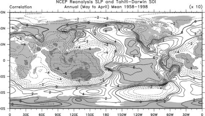
Figure 3 (see color insert) Map of correlation coefficients (10) of the annual mean sea
level pressures (based on the year May to April) with the SOI showing the Southern
Oscillation pattern in the phase corresponding to La Nin
˜
a events. During El Nin
˜
o events
the sign is reversed [From Trenberth and Caron, 2000]. See ftp site for color image.
3 INTERANNUAL VARIATIONS IN CLI MATE 167

generally associated with El Nin
˜
o events in the Pacific and extends, for instance, into
western Canada, cool conditions typically prevail over the North and South Pacific
Oceans. To a first approximation, reverse patterns occur during the opposite La Nin
˜
a
phase of the phenomenon. However, the latter is more like an extreme case of the
normal pattern with a cold tongue of water along the equator.
The prominence of the SO has varied throughout this century. Very slow long-
term (decadal) variations are present; for instance, SOI values are mostly below the
long-term mean after 1976. This accompanies the generally above normal sea
surface temperatures in the western Pacific along the equato r (Fig. 2). The prolonged
warm ENSO event from 1990–1995 is very unusual and the 1997–1998 event is the
biggest on record in terms of sea surface temperature anomalies. The decadal atmos-
pheric and oceanic variations are even more pronounced in the North Pacific and
across North America than in the tropics and also present in the South Pacific, with
evidence sugges ting they are at least in part forced from the tropics. It is possible that
climate change associated with increasing greenhouse gases in the atmosphere,
which contribute to global warming, may be changing ENSO, perhaps by expanding
the west Pacific warm pool.
Changes associated with ENSO produce large variations in weather and climate
around the world from year to year, and often these have a profound impact on
humanity and society because of droughts, floods, heat waves, and other changes
that can severely disrupt agriculture, fisheries, the environment, health, energy
demand, and air quality and also change the risks of fire. Changes in oceanic
conditions can have disastrous consequences for fish and sea birds and thus for
the fishing and guano industries along the South American coast. Other marine
creatures may benefit so that unexpected harvests of shrimp or scallops occur in
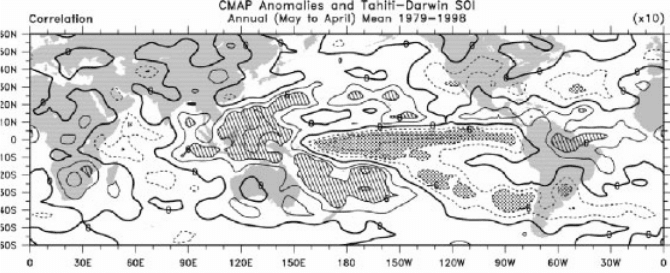
Figure 4 Correlations of annual mean precipitation with the SOI for 1979–1998. The
pattern has the phase corresponding to La Nin
˜
a events, and during El Nin
˜
o events the sign is
reversed, i.e., the stippled areas are wetter and hatched areas drier in El Nin
˜
o events [From
Trenberth and Caron, 2000]. See ftp site for color image.
168
THE EL NIN
˜
O–SOUTHERN OSCILLATION (ENSO) SYSTEM
some places. Rainfalls over Peru and Ecuador can transform barren desert into lush
growth and benefit some crops but can also be accompanied by swarms of grass-
hoppers and increases in the populations of toads and insects. Human health is
affected by mosquito-borne diseases such as malaria, dengue, and viral encephalitis
and by water-borne diseases such as cholera. Economic impacts can be large, with
losses typically overshadowing gains. This is also true in La Nin
˜
a events and arises
because of the extremes in flooding, drought, fires, and so on that are outside the
normal range.
4 MECHANISMS OF ENSO
During El Nin
˜
o, the trade winds weaken, causing the thermocline to become shal-
lower in the west and deeper in the eastern tropical Pacific (Fig. 5), while sea level
falls in the west and rises in the east by as much as 25 cm as warm waters surge
eastward along the equator. Equatorial upwelling decreases or ceases and so the cold
tongue weakens or disappears and the nutrients for the food chain are substantially
reduced. The resulting increase in sea temperatures warms and moistens the over-
lying air so that convection breaks out and the convergence zones and associated
rainfall move to a new location with a resulting change in the atmospheric circula-
tion. A further weakening of the surface trade winds completes the positive feedback
cycle leading to an ENSO event. The shift in the location of the organized rainfall in
the tropics and the latent heat released alters the heating patterns of the atmosphere.
Somewhat like a rock in a stream of water, the anomalous heating sets up waves in
the atmosphere that extend into midlatitudes, altering the winds and changing the jet
stream and storm track s.
Although the El Nin
˜
os and La Nin
˜
as are often referred to as ‘‘events’’ that last a
year or so, they are somewhat oscillatory in nature. The ocean is a source of
moisture, and its enormous heat capacity acts as the flywheel that drives the
system through its memory of the past, resulting in an essentially self-sustained
sequence in which the ocean is never in equilibrium with the atmosphere. The
amount of warm water in the tropics builds up prior to and is then depleted
during ENSO. During the cold phase with relatively clear skies, solar radiation
heats up the tropical Pacific Ocean, the heat is redistributed by currents, with
most of it being stored in the deep warm pool in the west or off the equator.
During El Nin
˜
o heat is transported out of the tropics within the ocean toward
higher latitudes in response to the changing currents, and increased heat is released
into the atmosphere mainly in the form of increased evaporation, thereby cooling the
ocean. Added rainfall contributes to a general warming of the global atmosphere
that peaks a few months after a strong El Nin
˜
o event. It has therefore been suggested
that the time scale of ENSO is determined by the time required for an accumulation
of warm water in the tropics to essentially recharge the system, plus the time for the
El Nin
˜
o itself to evolve. Thus a major part of the onset and evolution of the events is
determined by the histor y of what has occurred 1 to 2 years previously. This also
means that the future evolution is predictable for several seasons in advance.
4 MECHANISMS OF ENSO 169

5 OBSERVING ENS O
In the early 1980s, the observing system for weather and climate revolved around
requirements for weather forecasting, and there was little routine monitoring of
ocean conditions. Oceanographic observations were mostly made on research
cruises, and often these were not available to the community at large until
months or years later. Satellite observations of the ocean surface and atmosphere
provided some information on sea surface temperatures and clouds, but processing
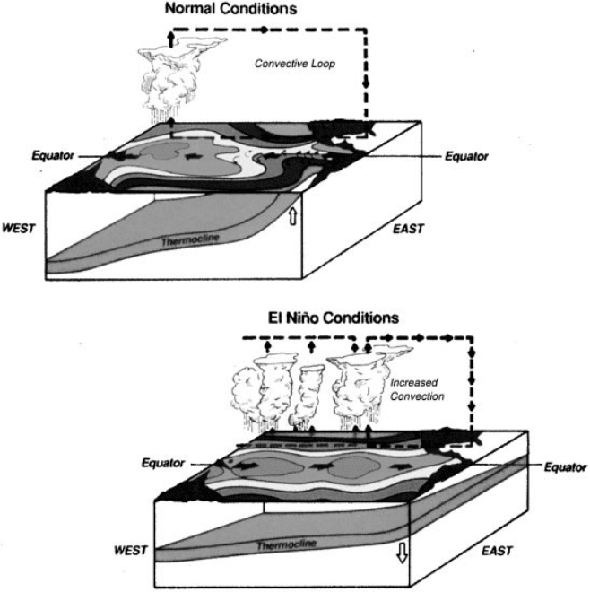
Figure 5 (see color insert) Schematic cross section of the Pacific Basin with Australia at
lower left and the Americas at right depicting normal and El Nin
˜
o conditions. Total sea surface
temperatures exceeding 29
C are in gold and the colors change every 1
C. Regions of
convection and overturning in the atmosphere are indicated. The thermocline in the ocean is
shown in blue. Changes in ocean currents are shown by the black ar rows. (Copyright
University Corporation for Atmospheric Research. Reprinted by permission). See ftp site
for color image.
170
THE EL NIN
˜
O–SOUTHERN OSCILLATION (ENSO) SYSTEM
of all the relevant information for ENSO was not routinely available. This meant
that in 1982–1983, during the largest El Nin
˜
o seen to that point, the tropical
Pacific was so poorly observed that the El Nin
˜
o was not detected until it was
well underway. A research program called Tropical Oceans–Global Atmosph ere
(TOGA) was begun in 1985 until 1994 to explore ENSO and to build a system to
observe and perhaps predict it. The understanding of ENSO outlined above has
developed largely as a result of the TOGA program and an observing system has
been put in place.
The ENSO observing system has developed gradually and was fully in place at
the end of 1994, so the benefits from it and experience with it are somewhat limited.
A centerpiece of this observing system is an array of buoys in the tropical Pacific
moored to the ocean bottom known as the TAO (Tropical Atmosphere–Ocean) array.
The latter is maintained by a multinational group spearheaded in the United States
by the National Oceanic and Atmospheric Administration’s (NOAA’s) Pacific Marine
Environmental Laboratory (PMEL). This array measures the quantities believed to
be most important for understanding and predicting ENSO. Each buoy has a seri es
of temperature measurements on a sensor cable on the upper 500 m of the mooring,
and on the buoy itself are sensors for surface wind, sea surface temperature (SST),
surface air temperature, humidity, and a transmitter to a satellite. Some buoys also
measure ocean currents down to 250 m depth. Observations are continually made,
averaged into hourly values, and transmitted via satellite to centers around the world
for prompt processing. Tapes of data are recovered when the buoys are serviced
about every 6 months by ships.
Other key components of the ENSO observing system include surface drifting
buoys, which have drogues attached so that the buoy drifts with the currents in the
upper ocean and not the surface wind. In this way, displacements of the buoy provide
measurements of the upper ocean currents. These buoys are also instrumented to
measure sea surface temperatures and, outside of the tropics, surface pressure. These
observations are also telemetered by satellite links for immediate use.
Observations are also taken from all kinds of ships, referred to as ‘‘volunteer
observing ships.’’ As well as making regular observations of all surface meteorological
observations, some of these ships are recruited to do expendable bathythermograph
(XBT) observations of the temperatures of the upper 400 m of the ocean along regular
ship lines. Another valuable part of the observing system is the network of sea level
stations. Changes in heat content in the ocean are reflected in changes in sea level. New
measurements from satellite-borne altimeters are providing much more comprehen-
sive views of how sea level changes during ENSO.
Considerable prospects exist for satel lite-based remote sensing, including obser-
vations of SSTs, atmospheric winds, water vapor, precipitation, aerosol and cloud
properties, ocean color, sea level, sea ice, snow cover, and land vegetation. Conti-
nuity of consistent calibrated observations from space continues to be an issue for
climate monitoring because of the limited lifetimes of satellites (a few years);
replacement satellites usually have somewhat different orbits and orbits decay
with time. All the ship, buoy, and satellite observations are used together to provide
analyses, for instance, of the surface and subsurface temperature structure.
5 OBSERVING ENSO 171
6 ENSO AND SEASONAL PREDICTIONS
The main features of ENSO have be en captured in models that predict the anomalies
in sea surfa ce temperatures. Lead times for predictions in the tropics of up to about a
year have been shown to be practicable. It is already apparent that reliable prediction
of tropical Pacific SST anomalies can lead to useful skill in forecasting rainfall
anomalies in parts of the tropics, notably those areas featured in Figure 4. While
there are certain common aspects to all ENSO events in the tropics, the effects at
higher latitudes are more variable. One difficulty is the vigor of weather systems in
the extratropics, which can override relat ively modest ENSO influences. Neverthe-
less, systematic changes in the jet stream and storm tracks do occur on average,
thereby allowing useful predictions to be made in some regions, although with some
uncertainty inherent.
Skillful season al predictions of temperatures and rainfalls have the potential for
huge benefits for society. However, because the predictability is somewhat limited,
a major challenge is to utilize the uncertain forecast information in the best way
possible throughout different sectors of society (e.g., crop production, forestry
resources, fisheries, ecosys tems, water resources, transportation, energy use).
Considerations in using a forecast include how decisions are made and whether
they can be affected by new information. The implication of an incorrect forecast
if acted upon must be carefully considered and factored into decisions along with
estimates of the value of taking actions. A database of historical analogs (of past
societal behavior under similar circumstances) can be used to support decision
making. While skillful predictions should positively impact the quality of life in
many areas, conflicts among different users of information (such as hydroelectric
power versus fish resources in water management) can make possibly useful
actions the subject of considerable debate. The utility of a forecast may vary
considerably according to whether the user is an individual versus a group or
country. An individual may find great benefits if the rest of the community ignores
the information, but if the whole community adjusts (e.g., by growing a different
crop), then supply and market prices will change, and the strategy for the best crop
yield may differ substanti ally from the strategy for the best monetary retur n. On
the other hand, the individual may be more prone to small-scale vagaries in
weather that are not predictable. Vulnerability of individuals will also vary accord-
ing to the diversity of the operation, whether there is irrigation available, whether
the farmer has insurance, and whether he or she can work off the farm to help out
in times of adversity.
ACKNOWLEDGMENTS
This research was partially sponsored by NOAA Office of Global Programs grant
NA56GP0247 and the joint NOAA=NASA grant NA87GP0105.
172 THE EL NIN
˜
O–SOUTHERN OSCILLATION (ENSO) SYSTEM
BIBLIOGRAPHY
Chen, D., S. E. Zebiak, A. J. Busalacchi, and M. A. Cane (1995). An improved procedure for El
Nino forecasting: Implications for predictability, Science 269, 1699–1702.
Glantz, M. H. (1996). Currents of Change. El Nino’s Impact on Climate and Society,
Cambridge University Press, Cambridge, New York.
Glantz, M. H., R. W. Katz, and N. Nicholls (Ed.) (1991). Teleconnections Linking Worldwide
Climate Anomalies, Cambridge University Press, Cambridge, New York.
Kumar, A., A. Leetmaa, and M. Ji (1994). Simulations of atmospheric variability induced by
sea surface temperatures and implications for global warming, Science 266, 632–634.
McPhaden, M. J. (1995). The Tropical Atmosphere–Ocean Array is completed, Bull. Am.
Meteor. Soc. 76, 739–741.
Monastersky, R. (1993). The long view of the weather, Science News 144, 328–330.
National Research Council (1996). Learning to Predict Climate Variations Associated with El
Nino and the Southern Oscillation: Accomplishments and Legacies of the TOGA Program,
National Academy Press, Washington D.C.
Patz, J. A., P. R. Epstein, T. A. Burke, and J. M. Balbus (1996). Global climate change and
emerging infectious diseases, J. Am. Med. Assoc., 275, 217–223.
Philander, S. G. H. (1990). El Nino, La Nina, and the Southern Oscillation, Academic Press,
San Diego, CA.
Suplee, C. (1999). El Nino=La Nina, National Geographic, March, pp. 72–95.
Time (1983). Australia’s ‘‘Great Dry,’’ Cover story, March 28, pp. 6–13.
Trenberth, K. E. (1997a). Short-term climate variations: Recent accomplishments and issues
for future progress, Bull. Am. Met. Soc. 78, 1081–1096.
Trenberth, K. E. (1997b). The definition of El Nino, Bull. Am. Met. Soc. 78, 2771–2777.
Trenberth, K. E. (1999). The extreme weather events of 1997 and 1998, Consequences 5(1),
2–15, (http:==www.gcrio.org=CONSEQUENCES=vol5no1=extreme.html).
Trenberth, K. E., and J. M. Caron (2000). The Southern Oscillation revisited: Sea level
pressures, surface temperatures and precipitation, J. Climate, 13, 4358–4365.
BIBLIOGRAPHY 173

SECTION 3
PHYSICAL METEOROLOGY
Contributing Editor: Gregory Tripoli
