Morris & Fan. Reservoir Sedimentation Handbook
Подождите немного. Документ загружается.

CASE STUDY: SANMENXIA RESERVOIR 24.16
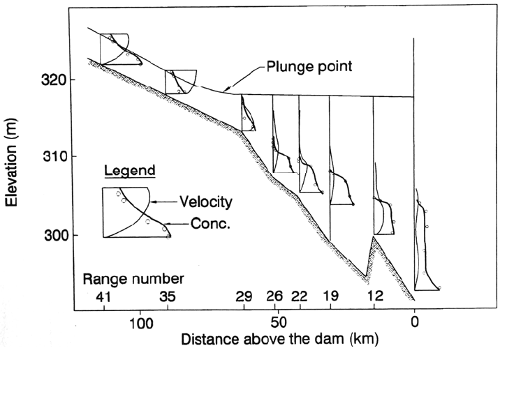
FIGURE 24.12 Turbidity current along the 65-km impounded reach downstream of Range 29
during August 16-18. 1961 (Shaanxi Provincial Institute of Hydraulic Research and Qinghu
a
University, 1978).
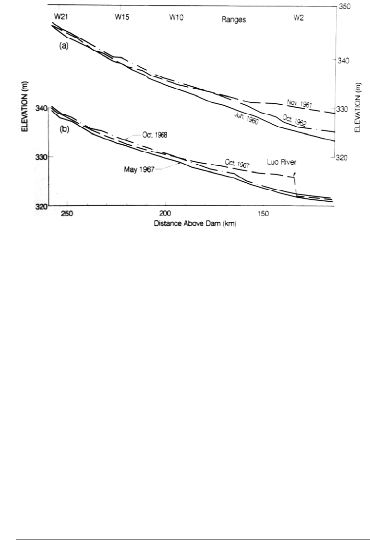
by comparing the June 1960 pre-impoundment profile along Wei River against the
November 1961 profile (Figure 24.13a). The next measurement in October
1962 showed that, although the level near the mouth of the Wei River had
lowered, deposition remained in the river channel as far as 250 km upstream.
24.7.2 Local Deposition from Luo River
Submerged deposits may be formed in two areas along the lower Wei River:
upstream of the confluence with the Yellow River or at the tributary Luo River located
19 km upstream of the Yellow River confluence. Deposits created by the intrusion
of sediment-laden water from the Yellow River upstream along the Wei River can be
eroded quickly by subsequent discharge from the Wei River, but deposits farther
upstream created by deposition from the Luo River require much longer to remove.
Serious deposition from the Luo River occurred during August and September
1967, when high water levels (above 330 m) were maintained at Tongguan by
five flood periods of 5000 m/s along the Yellow River. During this period, both the
Wei and Luo Rivers had low discharges, but the Luo River discharge was
hyperconcentrated, with a monthly mean concentration of 538 kg/m
3
. The
resulting sand bar in the Wei River channel is shown in Fig. 24.13b. The
subsequent October 1968 measurement along the Wei River showed that the Luo
River bar had been mostly washed out of the lower river reach, but upstream of about
km 190, the bed levels in 1968 were even higher than they had been in 1967 when the
mouth bar was formed. This illustrates the lag times involved in sediment profile
adjustments, which may result in the continuing accumulation of sediment in an
upstream reach at the same time the downstream reach is eroding. In 1961-1962 and
again in 1968-1969, the zone of channel deposition moved upstream along
CASE STUDY: SANMENXIA RESERVOIR 24.17
FIGURE 24.13 Longitudinal deposition in river channel with retrogressive deposition in the
Lower Reach of Wei River, (a) 1960-1962 and (b) 1967-1969, in terms of water level
at Q = 200 m
3
/s (Zhang and Long, 1980).
the Wei River (retrogressive deposition). The upstream movement of the deposit limit,
and the downward erosion through previous deposits, were at different times observed to
occur simultaneously or alternately.
24.7.3 Turbidity Current from Yellow River
High flows in the Yellow River that create backwater conditions upstream of Tongguan
can cause turbid water in the Yellow River to plunge and flow upstream along the Wei
River. Some of the velocity profiles measured during these events showed surface
water from the Wei River flowing downstream while silt-laden bottom water from the
Yellow River traveled upstream. Deposition from the turbidity current moving
upstream along the Wei River causes bottom sediment to be sorted from coarse to
fine proceeding upstream, opposite to the sorting direction imposed by normal flow.
More complex deposition patterns occur when hyperconcentrated flow from the Luo
River also plunges beneath the Wei River. Prior to dam construction, the Yellow
River flowed upstream into the Wei River and formed a river-mouth bar at intervals
of about 10 years: in 1932, 1942, 1954, and 1959. The greater the flood of the
Yellow River relative to the discharge of the Wei River, the more serious the
deposition. Backwater effects from dam construction caused flow reversal to occur
more frequently.
24.8 RETROGRESSIVE EROSION
When bottom outlets are opened and a reservoir is emptied for flushing, the area in
front of the bottom outlets will typically be scoured first. This creates steep-gradient,
CASE STUDY: SANMENXIA RESERVOIR 24.18
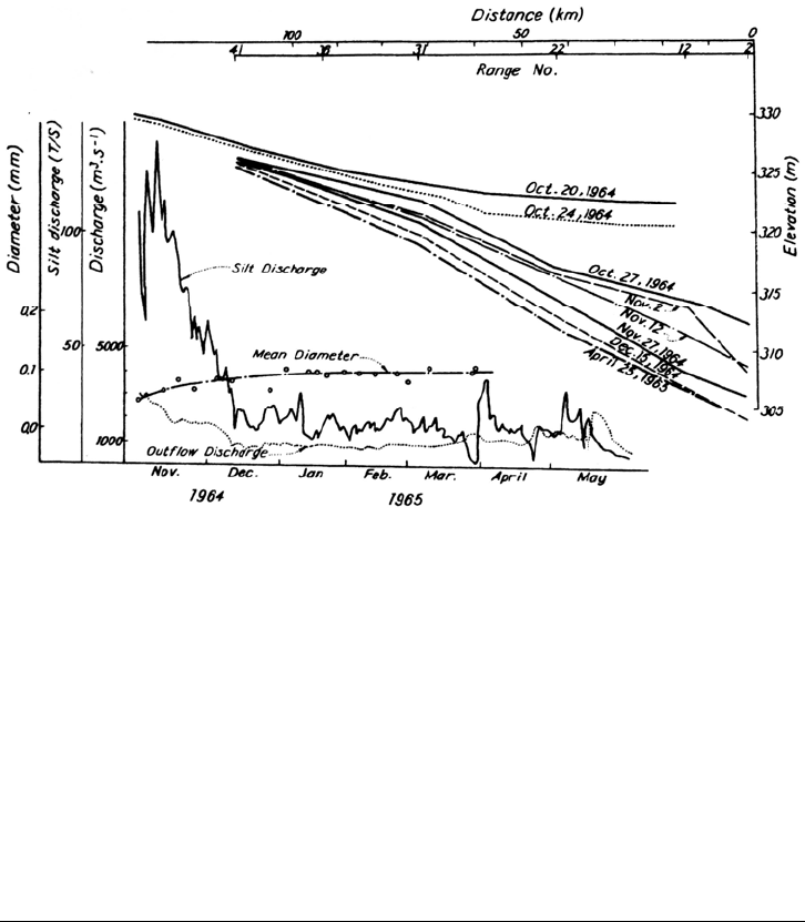
FIGURE 24.14 Development of retrogressive erosion by flushing in Sanmenxia Reservoir as
indicated by the sequence of reservoir water-level profiles (Fan, 1985).
super-critical flow, and a zone of extremely active erosion which moves
upstream as the eroded material is carried away. During the 1964 flushing event,
retrogressive erosion was observed to begin near Sanmenxia Dam and eventually
extended more than 100 km upstream, the greatest length of retrogressive erosion
documented in a reservoir. Development of the longitudinal erosion pattern is in-
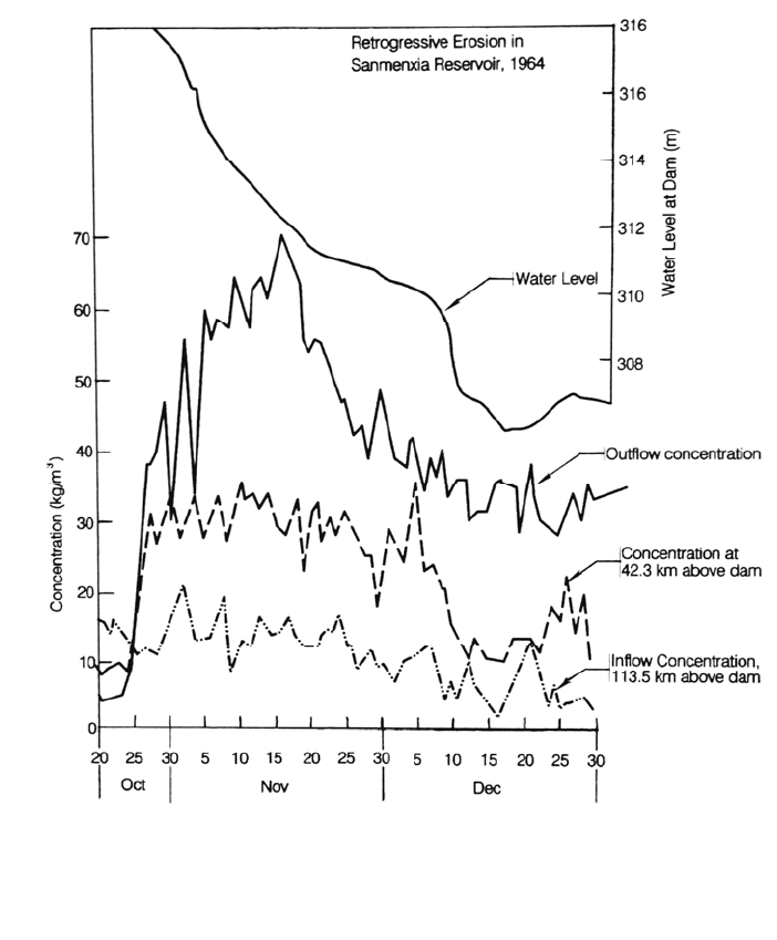
dicated by the sequence of reservoir water level profiles given in Fig. 24.14. The time-
wise variation in water level and sediment concentration at various points during retro-
gressive erosion are illustrated in Fig. 24.15. Outflow sediment concentration increased
rapidly as soon as drawdown was initiated and declined gradually thereafter. Most of the
net increase in sediment concentration occurred between km 42.3 and the dam.
24.9 SEDIMENT DISCHARGE DOWNSTREAM
Below Sanmenxia Dam, the Yellow River emerges from the 130-km-long gorge
reach at Mengin and flows 858 km across an alluvial plain to the sea. These alluvial
plains, the traditional heartland of the Chinese civilization, have been the site of
catastrophic floods for millennia, and records of major flood control efforts date
back over 2000 years. Effective flood control measures in the form of an immense
system of dikes have been constructed only since the 1950s. Because of the
continuous accumulation of sediment along the alluvial riverbed contained within
flood-control levees, the base elevation of the river has gradually risen and now
stands above the adjacent floodplains.
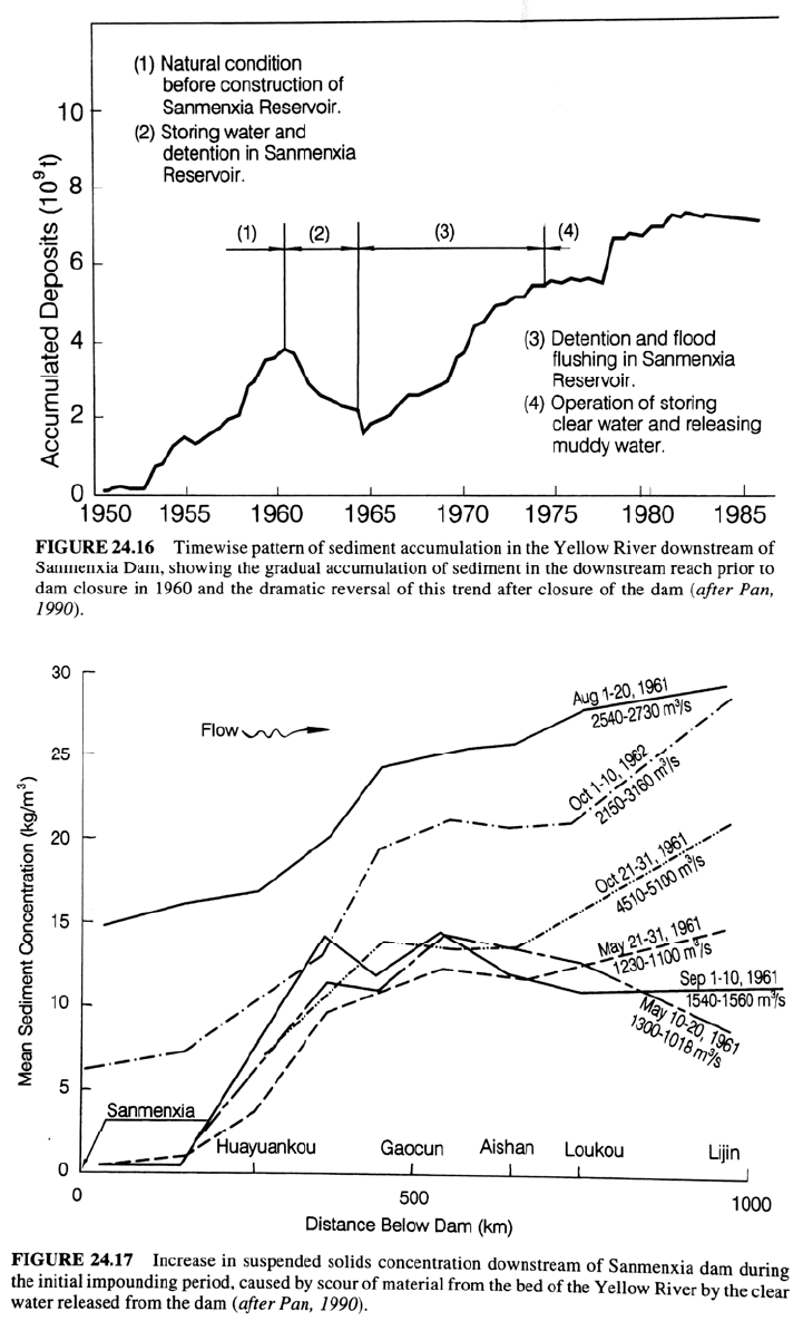
Figure 24.16 illustrates the timewise pattern of sediment accumulation in the Yellow
River downstream of Sanmenxia dam, showing the gradual accumulation of
sediment in the downstream reach prior to dam closure in 1960. During 1960-1964
the reservoir operated at a high trap efficiency and released clear water, causing a net
erosion of sediments from the Lower Yellow River. This erosion posed danger to
the earthen dikes because more constant, clear water discharges produced
CASE STUDY: SANMENXIA RESERVOIR 24.19
prolonged and concentrated scour in some areas, creating danger of bank collapse. In
contrast, the irregular sediment-laden flows prior to dam closure caused areas of
maximum scour to shift and be dissipated over longer sections of dike. Scour
depth decreased moving downstream along the Yellow River as the entrainment of
sediment from the river bed and banks gradually brought transport capacity into
balance with the available supply. This adjustment is evident from the longitudinal
variation in sediment concentration for different dates, shown in Fig. 24.17.
FIGURE 24.15 Timewise variation in water level and sediment concentration at various
points during retrogressive erosion (Shaanxi Provincial Institute of Hydraulic Research an
d
Qinghua University, 1978).
During the period of dam reconstruction, from 1964 through 1973, the reservoir
was operated for flood detention and sediment flushing with outlets open all year.
However, the limited flood discharge capacity of the outlets also limited sediment
transport capacity. During this period, high-concentration, low-discharge releases
from the dam exceeded the transport capacity in the downstream channel, and the
years 1965 through 1973 were characterized by serious sediment deposition along the
reach 300 to 400 km downstream of the dam. During this period 67 percent of the
CASE STUDY: SANMENXIA RESERVOIR 24.20

CASE STUDY: SANMENXIA RESERVOIR 24.21
deposition occurred in the channel of the Yellow River and only 33 percent on the
floodplain. Siltation in the main channel of the Lower Yellow River has serious flood
control consequences, and prevention of deposition in the main channel is the key
problem of river regulation and flood protection along the lower reach. Only after
reopening of the eight bottom outlets at 280 m, opening of two tunnels at 290 m, and
reconstruction of four penstocks could both sediment and water be discharged at the rates
required to better stabilize conditions downstream of the dam, as occurred after 1973.
Between March 1973 and October 1985, more than 90 percent of the sediment
deposition downstream of the dam occurred on the floodplain, and erosion occurred in
the channel, which is generally beneficial from the standpoint of flood protection along
the Lower Yellow River. However, channel deposition continues to occur at low river
discharge, and sediment regulation in the Lower Yellow River is still a problem that is
not fully solved.
24.10 CLOSURE
The Sanmenxia case study illustrates the potential complexity of sediment management
issues both upstream and downstream of a dam, and the use of an incremental approach
to solve difficult problems. The sediment problem was not sufficiently understood to
enable effective management until after years of intensive research and practical
experience had been gained. The knowledge gained at Sanmenxia formed the basis for
the design and management of subsequent reservoirs where sedimentation has been
considered from the early design stage, including the Shiaolongdi and Three Gorges
Projects in China.
It is also important to note that at Sanmenxia sediment management was not merely
an issue of achieving a sediment balance across the storage reach to preserve reservoir
capacity. It also required achievement of a sediment balance in the upper backwater
reach above Tongguan, and along the downstream reach extending to the ocean, to
prevent flooding due to sediment deposition. In all, Sanmenxia Dam seriously affected the
sediment balance and flooding problems along some 1300 km of the Yellow River and
its tributary, the Wei River, from the ocean upstream to the vicinity of Xian.

CHAPTER 25
CASE STUDY: HEISONGLIN
RESERVOIR, CHINA
25.1 OVERVIEW
Prior to the revolution in 1949 there were very few reservoirs in China. With chronic
food shortages, high population, and limited arable land, one of the first tasks of the new
government was to undertake widespread water resource development, giving heavy
emphasis to the construction of reservoirs for irrigation and flood control. The middle and
late 1950s saw the construction of numerous reservoirs, but in the highly erodible loess
region of northern China, the area drained by the Yellow River, these reservoirs rapidly
began filling with sediment. In some cases the rate of siltation was astounding. The Xinghe
Reservoir in Shaanxi Province required 2 years to construct but only one year to fill with
sediment, and the 21.8-Mm
3
Laoying Reservoir in Shaanxi Province silted up before the
irrigation canal was completed. It was quickly evident that water could not be managed
without simultaneously managing sediment (Xia, 1984). As a result of the severe reservoir
sedimentation problems, during 1960-1961 engineers and officials in Shaanxi Province
evaluated the situation at all reservoirs in the province. It was decided to utilize Heisonglin
Reservoir as an experimental site to intensely study the sedimentation phenomena and develop
sediment management techniques which could then be applied to other reservoirs within
the region.
Results at Heisonglin have been impressive: the reservoir capacity is stabilized with a
capacity:inflow ratio of approximately 0.20, and 100 percent of the inflow can be
diverted to irrigation use. At Heisonglin Reservoir, a combination of seasonal drawdown,
flushing, and turbidity current venting is used, and it was at this site that the lateral erosion
technique was first developed. The primary operational focus is on sediment routing, but
because of limited discharge capacity, flood retention periods up to several days' duration,
and heavy inflowing sediment loads, a significant part of the inflowing sediment is
temporarily deposited within the main channel and the hydrographs are typical of flushing
operations. The Chinese have classified Heisonglin as a flushing operation. This case
study is based on a site visit and discussions with Xia Mai-ding and operational personnel
at the reservoir in 1987 and subsequent written communication, in addition to the cited
literature.
25.2 SITE DESCRIPTION
Heisonglin Reservoir occupies a valley with a slope of about 1 percent, located in a hilly
region on the upstream reach of the Yeyu River, a tributary of the Wei River. The earth
dam, completed in May 1959, impounds water for irrigation and flood protection. Water

CASE STUDY: HEISONGLIN RESERVOIR, CHINA 25.2
deliveries are made to the river below the dam through a single 2 x 1.5 m low-level outlet
installed on the right side of the dam with a discharge capacity of 10 m
3
/s. The outlet is
controlled by two vertical sluices arranged in series in an intake tower. Irrigators
withdraw water from the river downstream of the dam using high-capacity river
diversions which were in use long before dam construction, and were thus sized to divert high
discharges of sediment-laden water produced by the intermittent summer storms
characteristic of the region.
A hydrologic station 7.5 km upstream of the dam was established in 1961; it gages
286 km
2
(77 percent) of the 370 km
2
watershed tributary to the reservoir. The inflowing
sediment load consists mostly of noncohesive silts with a d
50
of 0.025 mm. General
characteristics of the reservoir are presented in Table 25.1 and the general layout is
given in Fig. 25.1.
TABLE 25.1 Summary Characteristics of Heisonglin Reservoir
Parameter
Value
Total reservoir volume at 764.5 m spillway crest 8.6 × 10
6
m
3
Dead pool 0.7 × 10
6
m
3
Mean annual inflow (1961-1972) 14.2 × 10
6
m
3
Mean annual sediment inflow (1961-1972) 0.71 × 10
6
tons
Mean annual sediment yield (1961-1972) 2475 ton/km
2
Sediment size (d
50
) 0.025 mm
Watershed area 370 km
2
Source: Ren (1986); Xia and Ren (1980).
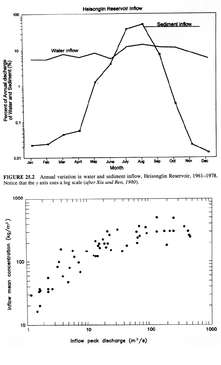
The mean sediment concentration at the inflow gage station is 50 g/L and peak
inflowing sediment concentrations exceed 800 g/L (Zhang et al., 1976). Sediment
discharge is both irregular and highly concentrated in time: 87 percent of the annual
sediment load enters the reservoir during July and August, yet these same 2 months
contribute only 25 percent of average annual runoff (Fig. 25.2). Summer flood events at
Heisonglin are caused by short intense summer rainstorms having steep rising and
falling hydrographs and durations on the order of several hours. These events produce
extremely high rates of gully erosion in the hilly loessal soils. The relationship between
peak flood discharge and the average suspended-sediment concentration at the inflow
gage station during flood events is shown in Fig. 25.3.
Between May 1959 and June 1962, the first 3 years following construction when the
reservoir was operated in continuous impounding mode, 1.62 Mm
3
of sediment
accumulated in the reservoir, representing a storage loss of 6 percent per year and a trap
efficiency estimated at 76 percent on the basis of long-term sediment inflow of 0.71
Mt/yr. At this rate the reservoir would become completely silted up after 16 years of
operation. Starting in 1962, reservoir operation was changed to incorporate seasonal
emptying during the flood season while continuing to impound water during nonflood
season when sediment loads were smaller by employing the strategy, "Store the clear
water and discharge the muddy water." Turbid density currents were also released. These
measures reduced trap efficiency to about 15 percent but the reservoir continued to lose
capacity. As a result of additional work, the lateral erosion technique was developed and
first implemented at this site in 1980 by Xia Mai-Ding and coworkers (Xia, 1986). This
technique was found to be capable of arresting sediment accumulation and recovering a
CASE STUDY: HEISONGLIN RESERVOIR, CHINA 25.3
Distance (m)
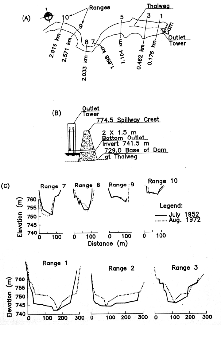
FIGURE 25.1 Geometry of Heisonglin Dam and Reservoir, Shaanxi Province, China. (a) Plan
view showing range locations; (b) sketch of dam cross section; (c) selected ranges (after Ren,
1986).
CASE STUDY: HEISONGLIN RESERVOIR, CHINA 25.4
FIGURE 25.3 Mean suspended-sediment concentration in inflowing floods versus peak discharge,
Heisonglin Reservoir (after Northwest Institute of Hydraulic Research et al., 1983).