Morris & Fan. Reservoir Sedimentation Handbook
Подождите немного. Документ загружается.

DECOMMISSIONING OF DAMS 17.14
facility to ensure that flood management benefits historically provided by the dam
continue to be offered. The owner may also be required to monitor sediment
deposition at the upstream limit of the pool and to amend the flood management
operation as required to minimize flood hazard to communities upstream of the pool
in the reach affected by streambed aggradation. Should the decommissioning plan
call for partial or complete darn removal, with sediment release that results in
morphological changes in the river reach below the dam site, a flood management
plan may call for monitoring and improvements to levee and related flood
control systems downstream if downstream bed aggradation is anticipated.
17.4.5 Aquatic Habitat and Life
Depending on the size of the project and the sensitivity of the downstream river reach,
intensive biological studies may be required to determine the impact of changes in water
quality on aquatic life along the fluvial system affected by the dam. The
decommissioning and removal of a dam will influence the fluvial environment in a
number of ways, including changes in benthos, flow duration, and peak discharge.
Effects on the environment include changes in temperature, turbidity, and
degradation of spawning gravel due to deposition of fine sediments.
Should reservoirs having significant effects on turbidity or temperature be removed
by decommissioning, the downstream ecosystem will be affected. Similarly,
reduction in the turbidity of water can affect a variety of processes, including
photosynthesis, and the predominance of certain kinds of predators. Reduced
turbidity will favor sight predators, and can have a significant impact on the
balance of aquatic life. Should turbidity increase after decommissioning, it will change
both the ability of sight predators to prey on other fish and will also affect plant life.
However, these impacts may be offset by many environmental benefits, such as the
restoration of the stream migration corridor by elimination of the barrier imposed by
the dam.
17.4.6 Social Effects
Social effects of dam decommissioning include the impacts of reduced efficiency of
flood protection, impacts on cultural resources and impacts to shoreline properties.
17.4.7 Legal Issues
Legal issues involving sedimentation can be wide and varied. In the United States the
taking issue is among the more relevant. It relates to the taking of property, or rendering
it unusable, by reason of increased flood hazard, the effects of erosion and
sedimentation, obstruction of land drainage, and impairment or loss of water rights.
These issues are covered by case law and the Tucker Act, which allows legal action
against the United States government for damages caused by improvements built by
the government.
17.4.8 Cost
Cost is a major factor determining the feasibility of dam decommissioning and
selection of the appropriate sediment management plan. Generally, dams are more costly

DECOMMISSIONING OF DAMS 17.15
to remove than to construct, and sediment management is one of the major cost
components of decommissioning.
17.5 EXAMPLES
Decommissioning with concurrent dam removal is a relatively new topic, and dam
removal in particular is controversial. In cases where owners decide that decommis-
sioning with concurrent dam removal makes economic sense, decommissioning and
removal is likely to take place on a voluntary basis. In other cases, for example,
when agencies such as the Federal Energy Regulatory Commission demand dam
removal, owners may be less willing to comply. This section first briefly contrasts
the responses of Edwards Manufacturing Co.. Inc. and of Consumers Power
Company to a FERC request for dam removal. While many reasons for the
differences in response may exist, one of the obvious differences is that the
hydroelectric plant owned by Edwards Manufacturing was still operating at the
time of request for dam removal, whereas the Consumers Power Company
hydroelectric facilities at Stronach Dam had already been decommissioned for many
years and dam removal was the only remaining decommissioning issue. The second
part of this section contrasts sediment removal issues at the urban North Avenue
Dam in downtown Milwaukee, with the issues at the Elwha and Glines Canyon
dams on the Olympic Peninsula in Washington state.
17.5.1 Edwards Manufacturing
Edwards Manufacturing (FERC, 1995) owns a hydroelectric facility on the
Kennebec River near Augusta, Maine. Upon application for project relicensing, resource
agencies and the Kennebec Coalition (an environmental group) argued that fish
passage at the site was inadequate. This resulted in a demand for decommissioning of
the project and dam removal. Edwards Manufacturing wishes to continue operation
of the plant and proposed alternatives for fish passage, such as installation of fish
ladders. FERC is currently issuing annual licenses that allow Edwards Manufactur-
ing to continue operation of the plant, a process which will continue until the
property is taken over or a new license is issued. The owner has not developed any
plans for decommissioning and dam removal, and the case is the subject of a
continuing legal battle.
17.5.2 Stronach Dam
Stronach Dam, owned by the Consumers Power Company, is located in the Pine
River, within the Manistee National Forest in Manistee County, Michigan. The dam
consists of an earth embankment approximately 10 m high with a concrete core. The
original project was constructed in 1911 and 1912. The dam is located at the foot
of the rapids over which the Pine River descends from the high valley banks to the
river bottom. The Pine River is characterized by a high sediment load, and by
1930 the pond above Stronach Dam was almost completely filled with sediment.
Conditions worsened because of continued sediment accumulation, and in 1953 the
hydroelectric plant was retired and the generators and auxiliary equipment were
removed. The trash racks were blocked and most of the flashboards were removed to
reduce the headwater elevation.
No removal of sediment occurred since decommissioning of the hydroelectric
equipment, and by 1996 the original surface area of 27 ha had tilled almost entirely with
DECOMMISSIONING OF DAMS 17.16
sediment. Both the dam owners and resource agencies agreed that removal of the dam
structure would have significant ecological, recreational, scenic, and aesthetic benefits,
and the owner subsequently requested permission from FERC to remove the
structure (FERC, 1996). FERC issued a new license for operation of the Tippy
Project, of which Stronach Dam is a part, while at the same time approving a
settlement agreement to remove Stronach Dam. The major components of the
Stronach Dam removal project are structural modification to allow staged drawdown
and removal of sediment by natural erosion, dam removal, stream stabilization, site
restoration, monitoring of wetland habitat, and studies of fisheries on the Pine River.
The dam removal plan submitted by Consumers Power Company consists of three
stages: (1) construction of a temporary water drawdown structure; (2) pond
drawdown, and (3) demolition of selected structures and restoration of the Pine River.
During stage 1, a steel A-frame structure equipped with stoplogs will be erected
concurrently with removal of part of the powerhouse through which flow will he
discharged. Construction is expected to require 6 months. Stage 2 of the project will
last 6.5 years and will entail the staged removal of stoplogs at a rate of 0.15 m
every three months. The objective is to achieve a gradual release of sediment from
the pond by natural erosion, at a rate that minimizes detrimental effects in the river
reach below the dam. Stage 3 of the project entails removing the temporary A-frame
structure, the embankment, and concrete core wall of the dam to create a channel through
which the river can flow, as well as the remaining appurtenant structures. The new
river channel through the deposits will be protected against continued erosion in
appropriate locations by riprap.
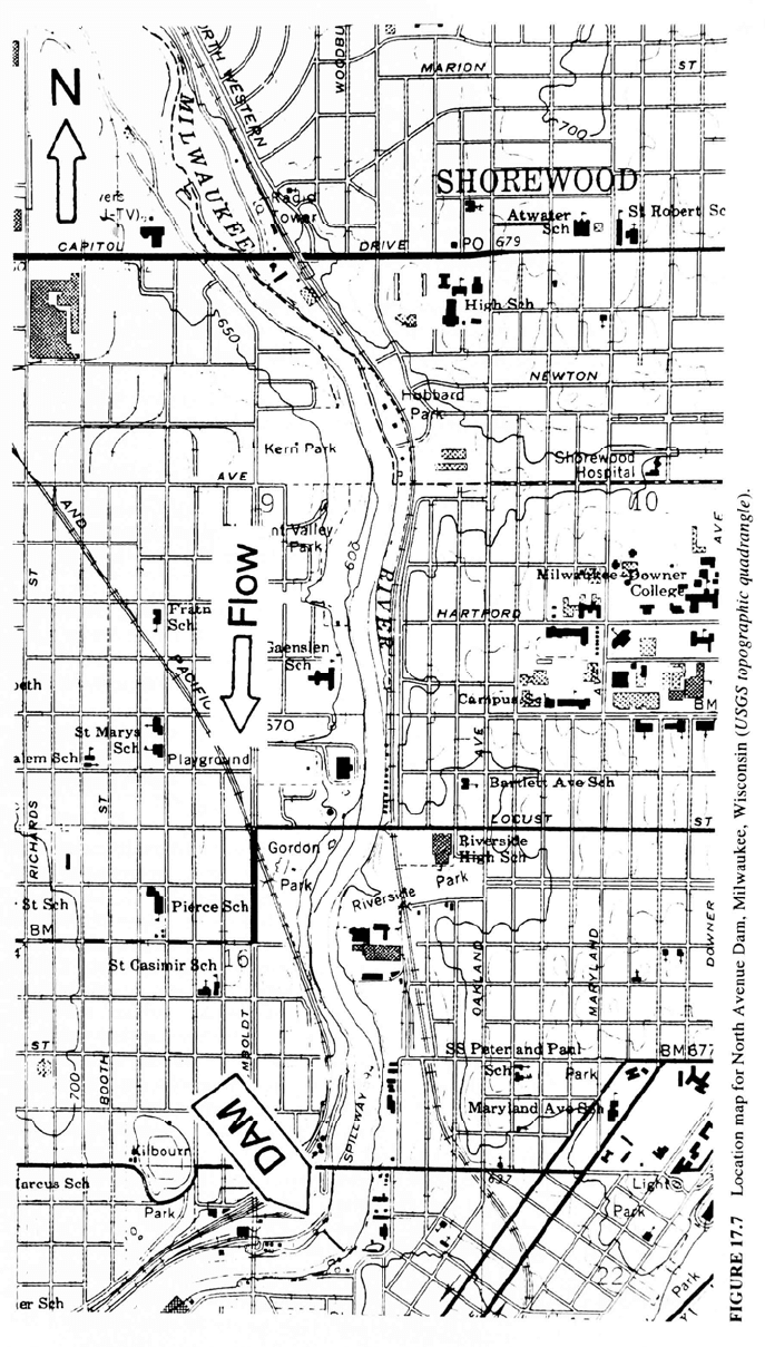
17.5.3 North Avenue Dam, Milwaukee, Wisconsin
The 5 m tall North Avenue Dam is located on the Milwaukee River about 5 km upstream
of Lake Michigan, and passes through downtown Milwaukee (Fig. 17.7). The dam
creates a small (33 ha) impoundment that is about 3.7 km long and averages only 87
m in width. Maximum water depth is about 3 m. The Milwaukee River was first dammed
in 1835 near the site of the present dam, to control water levels in the Milwaukee
River for a canal scheme which was never completed. The current dam forms an
artificial boundary between the river and the Milwaukee River Estuary, which was first
dredged in 1857 to allow large vessels to enter the river. Subsequent dredging
allowed vessels to reach an area just below the existing dam.
Despite the dam's small size, complex issues are associated with its management
(Woodward-Clyde Consultants, 1994). Surface water quality within the impound-
ment is seriously degraded by low dissolved oxygen, high heavy metal concentra-
tions, high turbidity, high temperature, and high populations of algae and bacteria.
Fish kills have occurred within the impoundment. The dam constitutes a migration
barrier to fish and the sediments represent a source of contaminates which impair
water quality and recreational use of the river. After many decades of trapping
sediments and contaminants, today's sediment deposits are contaminated with
heavy metals, polychlorinated biphenyls (PCBs), polycyclic aromatic hydrocarbons
( PAHs), and a variety of oxygen- demanding materials.
The dam's gates had previously been opened to temporarily draw down the
reservoir in 1954, 1970, and 1985. In 1990 the dam's gates were opened and the
reservoir was drawn down to replace a water main and a bridge. When the gates were
opened the river ran along its original course, exposing about 18 ha (45 acres) of
contaminated sediment deposits along either side, an area that was called the
sediment flats. About 20 m
3
of urban debris such as auto parts and building
materials, plus more than 2000 tires, were removed from the sediment flats. which
were then revegetated to control erosion. After the impoundment was drawn down,
DECOMMISSIONING OF DAMS 17.17
DECOMMISSIONING OF DAMS 17.18
the Wisconsin Dept. of Natural Resources recommended that the reservoir's gates
remain open until completing a study to determine the potential effects on the
Milwaukee River of either keeping the impoundment or removing the dam.
Among the issues of importance at this site was that of contaminated sediment
ownership, due to the potential environmental liabilities and long-term management
costs. It was determined that the riparian property owners were also owners of the
sediment, whether it was submerged by the impoundment or exposed as a result of
opening gates or removing the dam.
Five management alternatives were considered, with capital costs ranging from
$114,000 to $15.8 million. Annual operation costs under all alternatives were
similar, between $138,000 and $253,000. Each of the five alternatives are briefly
described below, and the capital costs are indicated.
1. Close the dam's gates to impound water, submerging sediment flats, with no
additional remedial action other than minor repairs ($114,000).
2. Leave the dam's gates open, exposing the sediment flats, with no additional
remedial action other than minor repairs ($114,000).
3. Close the dam's gates to impound water, but remedial actions would be taken
to cap the submerged contaminated sediments to minimize health and
environmental risks ($15.8 million).
4. Remove the gated portion of the dam to the level of the original river channel
and remove portions of the spillway on either side of the gates to create a
trapezoidal cross section. Portions of the dam would remain in place to hold
upstream sediments in place. Sediment management activities would include
sediment consolidation, bank and channel stabilization, and revegetation
($5.7 million).
5. Completely remove the dam. This would expose a 4 m tall "wall" of
sediments, which would be graded back to a stable angle and protected with
geomembrane and riprap. Other sediment management activities would include
sediment consolidation, bank and channel stabilization, and revegetation ($6.5
million).
Alternatives involving drawdown of the impoundment also included modification to
an existing industrial water supply intake dewatered by the drawdown, protection of a
utility crossing, and activities for wildlife and recreational enhancement.
Each alternative was evaluated with respect to its effect on the following
resource parameters: water quality (dissolved oxygen, bacteria, and toxins); stream
hydraulics and flooding; sediment quality; recreational use (canoeing/kayaking,
sculling, hiking, disabled access, fishing access, birding, and view aesthetics); land
use, value and ownership; aquatic and riparian wildlife; utilities and infrastructure;
cultural resources; groundwater; and cost. The first two alternatives were discarded
because they would not meet the project's water quality objectives; contaminants
would continue to be released from the sediments. The fourth alternative, which was
recommended for implementation, was not only the least costly of the alternatives
considered acceptable from the standpoint of water quality, but would also provide
enhanced public recreational access because the revegetated and stabilized sediment
flats would become public property. It would provide a more diverse ecological
environment and improve water quality. Partial removal of the dam would also
eliminate a barrier to fish migration and allow recreational navigation through the
breached dam by canoe and kayak.
The riparian land along the length of the reservoir consists of a number of
different public and private properties, and the privately owned parcels tend to restrict
recreational access to the river and reservoir. It was recommended that private
landowners cede their ownership of contaminated sediment flats to the State. It was

DECOMMISSIONING OF DAMS 17.19
further recommended that both the City and County of Milwaukee, who are also
riparian landowners, perform sediment management work on their sediment flats
plus privately owned sediment flats, once the suitable deeds or easements were in
hand. Upon completion of remediation, all sediment flats would be deeded to the State
so that it would fall under unified ownership and operation and would provide
unrestricted public access. However, Milwaukee County would continue to own
upland areas, where it would maintain park and recreational facilities.
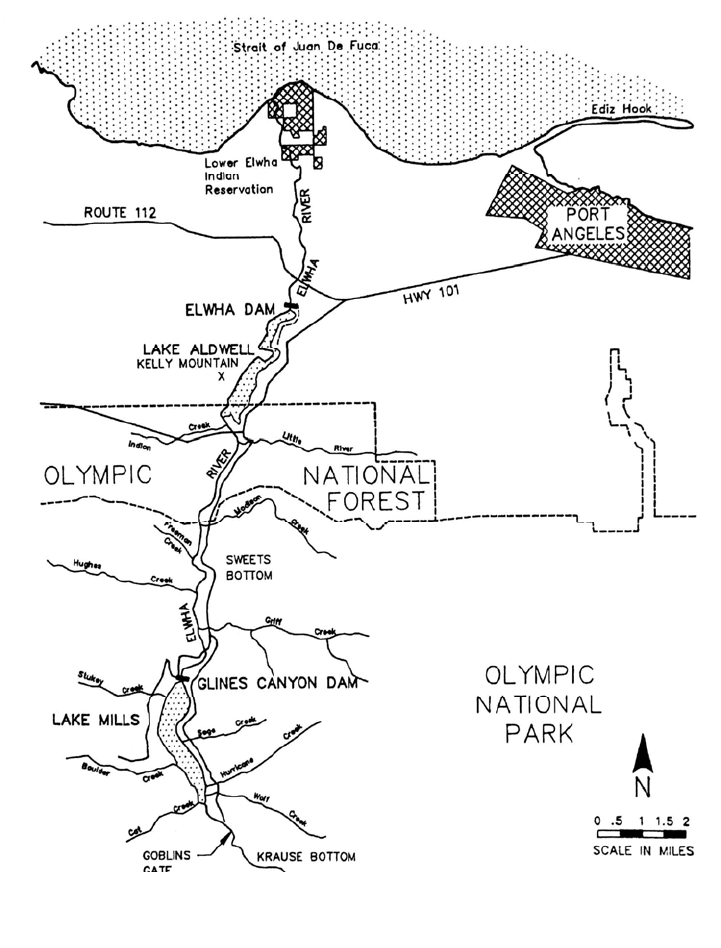
17.5.4 Glines Canyon and Elwha Hydroelectric Dams, Washington
State
The Elwha and Glines Canyon hydropower dams are located on the Elwha River on
Washington's Olympic Peninsula. Summary characteristics are given in Table 17.1. Pool
TABLE 17.1 Summary Characteristics of Darns on Elwha River.
E
lwha Glines Canyon
Year completed 1912 1927
Dam height (m) 32 64
Crest length (m) 137 82
Reservoir name Lake Aldwell Lake Mills
Source: FERC (1991).
levels vary little and both dams are operated essentially as run-of-river facilities. Upper
portions of the Elwha River are within Olympic National Park and represent some of the
most outstanding scenic and ecological resources in the United States. It is also designat-
ed a world biosphere reserve and a World Heritage Park by UNESCO. Glines Canyon
Dam and its reservoir, Lake Mills, lie entirely within Olympic National Park (Fig. 17.8).
Res
ervoir surface area (ha) 108 168
Original reservoir volume (10
6
m
3
) 10.0 49.4
Accumulated sediment in 1989 (10
6
m
3
) 3..2 8.3
Installed hydropower capacity (MW) 14.8 13.1
Average gross energy production (GWh/yr) 70 102
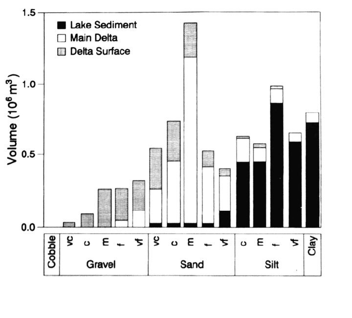
The generalized variation in grain size within the deposits above Glines Canyon Dam
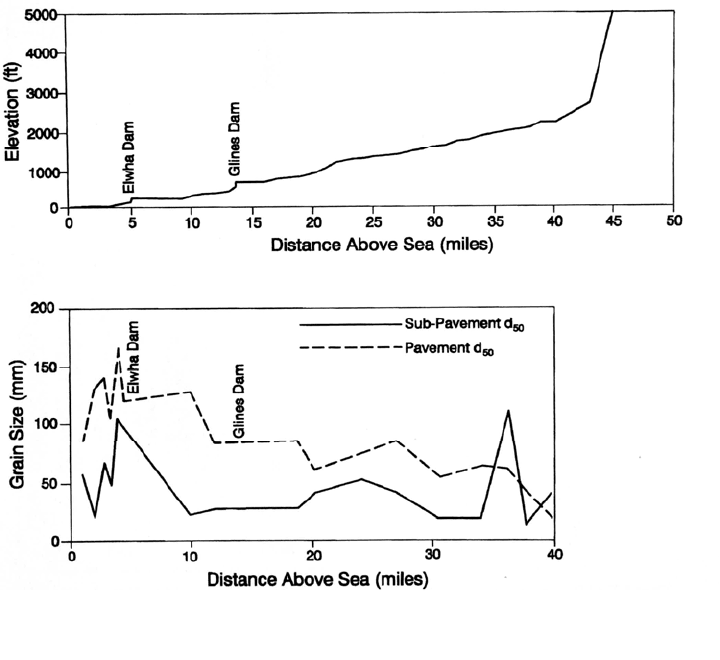
is presented in Fig. 17.9. Trapping of bed material within the reservoirs has caused
significant coarsening of the riverbed below the dams (Fig. 17.10), and dam construction
has also contributed to coastal erosion. Prior to the dams, the Elwha delivered about
30,000 m
3
/yr of coarse sediment to its delta. Longshore currents subsequently transported
this sediment eastward to Ediz Hook, with a travel time on the order of 10 years between
the delta and Ediz Hook (see location map in Fig. 17.8). Erosion in the area of the river
delta due to reduced sediment supply was first noticed in the period from 1926 to 1940,
and has also contributed significantly to subsequent shoreline erosion along the western
end of Ediz Hook.
Anadromous fish are those that migrate from freshwater to saltwater and then
return. In the Elwha the principal anadromous fish of historical significance are coho,
chinook, pink, and chum salmon, and steelhead trout. The Elwha fisheries were
generally described as prolific until dam construction began in 1910, but declined
DECOMMISSIONING OF DAMS 17.20
FIGURE 17.8 Location map for Elwha and Glines Canyon Dams and adjacent areas
(FERC, 1991).
d
ramatically thereafter. In addition to physically blocking migration, coarsening of the
below-dam riverbed has also made this zone less suitable for spawning.
The Lower Elwha Klallam Tribe has a reservation along the lower river, and has
repeatedly stressed the importance of the river and its anadromous fish resource as the
most significant single aspect of their cultural identity. For the aboriginal Klallam, the
DECOMMISSIONING OF DAMS 17.21
FIGURE 17.9 Grain size variation of sediment trapped above Glines Canyon Dam, as a
function of location within the reservoir (after FERC, 1991).
anadromous fishery was the most important source of food, both for immediate
consumption and long-term storage. In 1855 the United States Government granted fish
harvest rights to the Klallams and other signatories of the Point No Point Treaty, in
exchange for territorial claims. Subsistence and commercial fishing continued to
be their primary activity until dam construction, which decimated the fishery.
Removal of the dams would increase fisheries and help to restore these rights, as
well as provide more species and locally increased populations for both commercial
and sport fishing.
Environmental benefits of fisheries restoration will also extend to many other
species. Salmon die after spawning, and following removal of both dams it was
expected that over 400,000 kg/yr of salmon carcasses would be returned to the river
system for consumption by other wildlife. At least 22 different bird and mammal
species have been documented to feed on the carcasses of coho salmon.
Additionally, the increased population of fry and juvenile salmon will support
other predators.
Both dams were submitted to the Federal Energy Regulatory Commission
(FERC) for relicensing, which has been opposed by the Elwha Klallam Tribe and
environmental interests favoring restoring the Elwha's natural habitat. The draft
environmental impact statement (EIS) prepared by FERC (1991) to address the
relicensing issue provides the information used in this example. The EIS evaluated
the applicant's proposal for continued operation of the dams, with mitigation
measures to provide fish passage for some species, against alternatives incorporat-
ing the removal of either or both dams.
DECOMMISSIONING OF DAMS 17.22
FIGURE 17.10 Longitudinal profiles for Elwha River Showing (top) elevation profile, and
(bottom) d
50
grain size of bed material (after FERC, 1991).
Three primary resources objectives in this case were: (1) restoration of wild, self-
sustaining runs of anadromous fish; (2) restoration of natural conditions within Olympic
National Park, and (3) provision of renewable hydroelectric power. The restoration of
wild, self-sustaining runs of anadromous fish is a principal resource objective in the
Elwha River because the Elwah watershed provides unique opportunities for such
restoration, and because restoration of anadromous docks is a regional priority. FERC’s
analysis revealed the hydropower production and environmental enhancement objectives
to be mutually exclusive.
Four alternatives were considered: (1) the applicant’s proposed modification of both
dams to facilitate fish passage, (2) removal of Glines Canyon Dam only, (3) removal of
Elwha Dam only, and (4) removal of both dams. At the Elwha Dam the applicant
proposed the installation of fish ladders for upstream passage, screening of intakes, and
provision of a bypass system to facilitate the outmigration of juveniles to the ocean. At
the taller Glines Canyon Dam fish passage would be accomplished using a fish barrio
weir and a trap-and-haul system. However, these techniques would increase the
populations of only 2 of the 5 anadromous fish species affected by the dams.
While removal of the dams was greatly preferred from the environmental standpoint,
it represents a large cost in terms of foregone electrical power production. The value of
foregone power associated with dam removal was computed as the difference between

DECOMMISSIONING OF DAMS 17.23
TABLE 17.2 Economic Analysis Summary, Net Present Value Cost of the Alternatives.
Incremental costs
(thousand
s of 1996 dollars)*
Capita
l and
O&M Cost
Value of lost
Generation †
Total
Cost
Alternative
Applicant's dam retention proposal $ 35,583 $ 3,530 $ 39,113
Removal of both dams 80,855 164,221 245,076
Glines Canyon removal with retention of Elwha 84,383 99,960 184,343
Elwha removal with retention of Glines Canyon 35,088 67,881 102,969
*Present value of costs occurring over the 50-year period of analysis.
†Lost generation valued at the 50-year levelized cost of the region's long-term marginal generating resource.
Source: FERC, 1991.
the cost of hydropower production at the two dams, and the cost of producing a
comparable amount of power from a coal-fired power plant. The power cost was twice as
large as the cost of dam removal itself (Table 17.2).
Management of the accumulated sediment is a key issue associated with dam
removal. Because the watershed is in pristine condition and has never been logged, there
are no issues related to sediment contamination. However, the release of nutrients and
organic matter associated primarily with fine sediments could have deleterious
water quality effects downstream, including decreased oxygen levels and
increased nutrient levels. Fine sediments and organics may cause water quality
problems at drinking water intakes and at the fish hatchery intake. Ranney collector
wells installed 20 m below the bed of the Elwha River and used to supply the
City of Port Angeles could also be clogged by fine sediment and require
backflushing.
Both reservoirs have sizable delta deposits of coarse sediment, which must also
be managed. While it is desired to reestablish the transport of coarse material
along the river system, it is not desired to release these sediments rapidly. This could
smother spawning areas below the dam, cause downstream flooding, and interfere
with intakes.
The proposed strategy is to excavate a new river channel through the existing
sediment deposits, and to store the excavated sediment on top of the existing
sediment deposits in other areas of the reservoir. Drawdown and sediment stabilization
activities would be performed during periods of lower flow, March to October. Delta
sediments, consisting mostly sands and gravels, would be placed in terraces
located within the existing upper reservoir area but away from the future river
channel. A dragline operating from the surface of the delta would excavate the channel
along which the river will flow within the dewatered reservoir. This channel alignment is
illustrated in Fig. 17.11. Once substantial surfaces are exposed by drawdown,
conventional earthmoving equipment would be used. Trucks would haul
excavated material to the terrace surfaces, where it would be deposited at slopes
of about 4.5:1 (horizontal:vertical).
Most coarse material that washed further downstream in the reservoir during the
progressive drawdown would continue to be trapped in the lowered pool, from which it
could be excavated as levels continue to drop. However, most of the fines which
are eroded are expected to be flushed through the system and into the ocean as wash
load. Silt present on the reservoir bottom in the area near the dam would not be
moved by mechanical means. Instead, the silt that remains trapped outside the