Middleton G.V. (Ed.) Encyclopedia of Sediments and Sedimentary Rocks
Подождите немного. Документ загружается.

GEOTHERMIC CHARACTERISTICS OF SEDIMENTS AND SEDIMENTARY ROCKS 315
Table G6 Average heat-production values of some igneous rocks
(from Haenel, Ryback, and Stegena, 1988, p. 136)
Table C8 Thermal conductivities of some sedimentary rocks (from
Blackwell and Steele, 1992; lessop, 1990)
Rock type Heat production Rock type Conductivity range (W/mK)
Granite
Granodiorite/dacite
Diorite, quartzdiorite/andesite
Gabbro/basalt
Peridotite
Dunite
Table G7 Representative heat generation units (HGUs) for sediments/
sedimentary rocks (Haenel, Rybach, and Stegena, 1988, p. 136)
2.45
1.48
1.08
0.309
0.012
0.002
Limestone
Dolomite
Sandstone
Clay and siltstone
Shale
Anhydrite
Basalt
Granite
2.50-3.10
3.75-6.30
2.50-4.20
0.80-1.25
1.05-1.45
4.80-5.80
4.80-6.05
1.69-1.96
307-3.50
Rock type Heat production
Limestone
Dolomite
Quartzitic sandstone
Arkose
Graywacke
Shale and siltstone
Black shale
Salt
Anhydrite
0.62
0.36
0.32
0.84
0.99
1.80
5.50
0.012
0.090
The heat (H), partly generated by the radioactive isotopes of
Uranium (U), Thorium (Th), or Potassium (K), is dissipated
through the crust and overlying sediments or sedimentary
rocks and is measured in |iWm~". The heat is transmitted by
conduction, convection, or radiation. The amount of heat,
timing, and cause of heating is of prime importance to many
geological applications such as understanding cratonic sedi-
mentary basin development, generation and migration of
petroleum, emplacement of ore deposits, and sedimentary
diagenesis.
Igneous and metamorphic rocks which constitute the
Earth's crust are naturally radioactive and have different
heat-production rates. For example, granites usually contain
more radioactive elements than gabbros and basalts. Some
representative values are given in Table G6.
Some heat may be generated by radioactive elements within
the sediments themselves (Table G7). For example, black
shales may be highly radioactive, but other rock types such as
limestones and sandstone contain few radioactive elements,
except in special conditions, and, therefore, their heat
generation unit (HGUs) values are small. Evaporites essen-
tially are devoid of any radioactive elements and therefore the
HGUs are extremely small or nil. The radioactive sediments,
of course, contribute to the overall heat flow, but generally this
contribution is small (because of the thinness of the
sedimentary package) relative to the basement rocks (= crust),
which constitute infinitely more mass.
The heat flow in sedimentary basins, for the most part, is
computed from temperatures measured in boreholes, usually
drilled for purposes other than measuring temperature. A vast
amount of these data are available as bottomhole temperatures
(BHTs) or temperatures taken in drillstem tests (DSTs) during
logging of commercial wells drilled in search of petroleum, ore
deposits, or water. Temperatures also may be recorded in well
bores by conventional continuous temperature logging tech-
niques or by the new Distributed Optical-Fibre Temperature
Sensing technique (DTS). Temperatures measured during well
logging may be of questionable value depending on the
circumstances and conditions during their recording and
collection. If certain conditions are known and controlled,
then the values can be corrected to obtain a 'true' temperature.
Topography
In lowland areas or areas with little topographic
relief,
a
correction for topographic irregularities is not needed. In other
areas with considerable topographic
relief,
however, a correc-
tion factor needs to be applied.
Rock type and conductivity
Different rock types exhibit different thermal conductivities
and these values have been measured carefully in laboratories
under controlled conditions. A summary of values is presented
in Table G8.
Porosity and contained fluid or gas
The type of fluid or gas contained in pores of a rock affect their
conductivity and thus the computation of any value dependent
on the thermal conductivity (Table G8). Water, oil, or natural
gas all have different conductivities and alter the overall rock
conductivity, but usually the interporosity substance is known
and can be considered in the computations.
Past climatic conditions
This factor affects only the upper hundred meters or so of the
subsurface and the effect can be determined from any reliable
temperature log taken in a borehole. The correction for the
climatic change is relatively small, but could be important,
especially in areas of permafrost.
The computed heat-flow values, then, can be compared
from one location to another, plotted on a map, and contoured
for further interpretation (see for example Blackwell and
Steele, 1992; Cermak and Hurtig, 1979; Hamza and Munoz,
1996).
For reference, the average heat flow on continents is
approximately 62 mWm^ and for oceanic areas, it is slightly
higher at about 80 mWm^ (Jessop, 1990, p. 205).
Daniel F. Merriam
316
GLACIAL SEDIMENTS: PROCESSES, ENVIRONMENTS AND FACIES
Bibliography
Blackwell, D.D., and Steele, J.L. (eds.), 1992. Geothermal map of
North America.
Geological
Society of America, Map CSM007; scale:
1:5,000,000.
Cermak, V., and Hurtig, E., 1979. Heat flow map of Europe. In
Cermak, V., and Rybach, L., (eds.). Terrestrial Heat
Flow in
Europe.
Springer-Verlag, pp. 3-40.
Haenel, R., Rybach, L., and Stegena, L., 1988. Handbook of Terrestrial
Heat-flow Density Determination. Kluwer Academic Publishers.
Hamza, V., and Munoz, M., 1996, Heat flow map of South America.
Geothermics, 25(6): 599-646.
Jessop, A.M., 1990. Thermal
Geophysics.
Elsevier.
GLACIAL SEDIMENTS: PROCESSES,
ENVIRONMENTS AND FACIES
Introduction
Significance of glacial deposits
The importance of glacial sediments can be gauged from the
fact that 10 percent of the Earth's land surface currently is
covered by glacier ice, a figure that exceeded 30 percent during
the Quaternary glaciations of the last 2 Ma. Glacier ice has left
a complex, often patchy, record of deposition on land, and
offshore has contributed substantially to the build up of
continental shelves. In earlier geological history, the Earth
experienced several continental-scale glaciations, some of them
even more extensive than those of the Quaternary Period.
Glacial deposition is intimately associated with a wide range
of other processes, including fluvial, mass flowage, eolian,
lacustrine, and marine. The resulting facies associations are
highly variable, and without detailed investigation can be
subject to a wide range of interpretations. It is only within the
last three decades that studies of glacial processes in modern
settings have made it possible to develop plausible models of
past glacial depositional environments.
Understanding the nature of Quaternary glacial sediments
and their associated landforms is vital in glaciated areas of
North America and Europe, where sand and gravel extraction
is essential for construction purposes, and for sensible
management of water resources and waste disposal. Ancient
glacial deposits and associated facies are also economically
important; in some regions, since they control the presence of
petroleum resources, as for example in the Permo-Carbonifer-
ous and Neoproterozoic sequences of the Middle East and
South America.
Historical background
Today, it is common knowledge that the Earth experienced a
series of ice ages but, when the concept was first mooted in the
early 19"' century, it met with fierce opposition, as most of the
unconsolidated deposits {drift) that are familiar to geologists
were attributed to Noah's flood of the Old Testament, often
with the proviso that larger boulders ("erratics") were
deposited from icebergs (Hambrey 1994, Chapter
1
for review).
The Swiss natural historian, Agassiz, became the chief
protagonist of the "Ice Age Theory", and when he delivered
his ideas in 1837, they had a Europe-wide impact. In the
following decades, through Agassiz's influence, geologists in
the UK and North America gradually accepted the theory as
being applicable to their areas. In the second half of the 19"'
century, "ancient" glacial deposits (tillites) were recognized in
many parts of the world. However, even in the second half of
the 20"^ century, the glacial origin of supposed tillites was
challenged, notably those of Neoproterozoic age. It has taken
systematic sedimentological investigations, coupled with an
appreciation of modern glacial processes, to settle these
debates.
Extent of glacier ice today
The areal extent of glacier ice today has been documented by
the World Glacier Monitoring Service (1989) (Table G9). By
far the greatest expanses of ice are the ice sheets of Antarctica
(85.7 percent of area) and Greenland (10.9 percent). However,
it is the remaining 3.4 percent that impinges directly on human
civilization, and most detailed sedimentological studies have
focused on these smaller ice masses. The potential contribution
of the Antarctic ice sheet to sea level rise is 56 m, with the
Greenland ice sheet adding a further
7
m. The remaining
glaciers account for a mere fraction of
this.
Fluctuations of the
world's ice masses continue to affect global sea levels,
providing on-going eustatic controls on the sedimentary
processes on continental shelves.
Characteristics of glaciers
Mass balance
The state of health of a glacier is a reflection of the balance
between accumulation and ablation over periods of decades to
hundreds of years, or thousands of years in the case of the
polar ice sheets. The difference between accumulation and
ablation in any one year is referred to as mass balance, which is
positive if accumulation exceeds ablation and negative if the
reverse. Accumulation mainly takes the form of snow, which is
transformed or metamorphosed by burial, through firn, to
glacier ice. Ablation is largely accomplished by melting on
temperate glaciers, while in some regions calving from ice
masses into the sea accounts for the bulk of ice losses. Glaciers
are typically subdivided into an accumulation zone and an
ablation zone, separated by an equilibrium line where there is
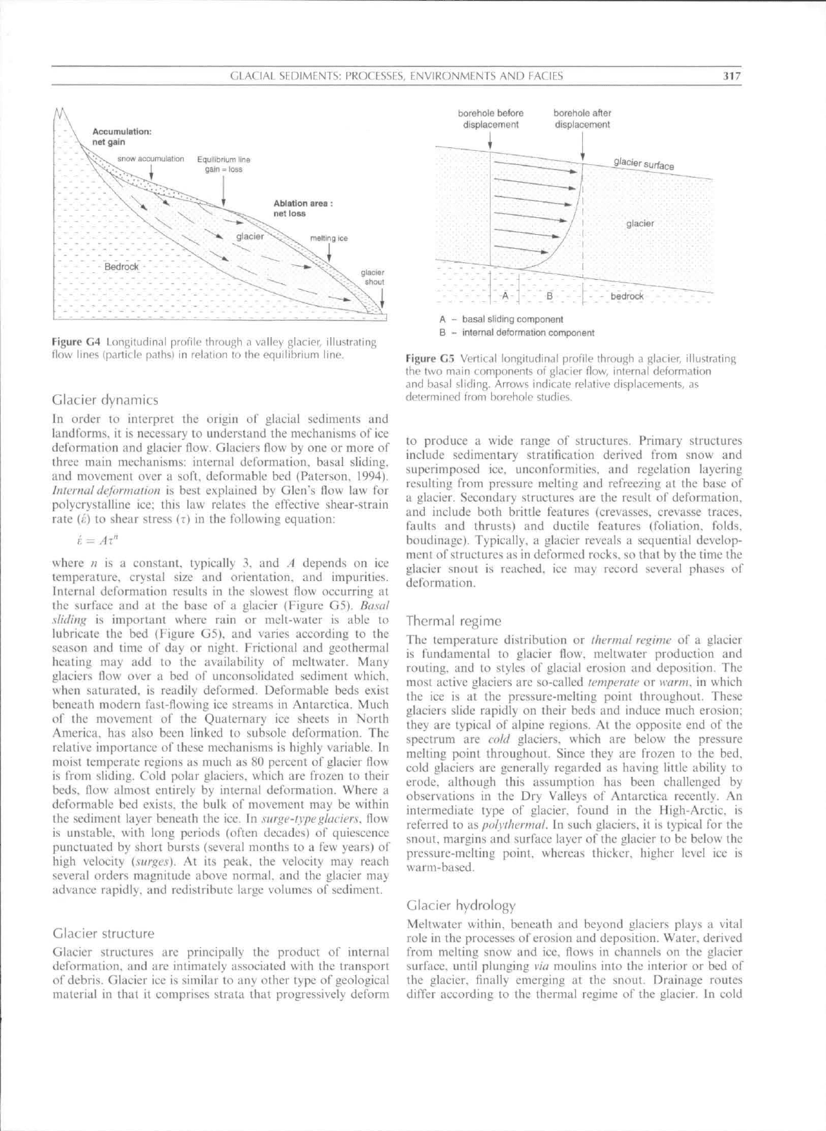
no net gain or loss of mass (Figure G4).
Table G9 Distribution of glacierized areas of the world
(World Glacier Monitoring Service, 1989)
Region
Africa
Antarctica
Asia and Eastern Europe
Australasia (i.e.. New Zealand)
Europe (Western)
Greenland
North America excluding Greenland
South America
World total
Area (km^)
10
13,593,310
185,211
860
53,967
1,726,400
276,100
25,908
15,861,766
GLACIAL SEDIMENTS: PROCFSSES, ENVIRONMENTS AND EACIES
317
borehoie before
displacement
borehole atler
displacemenl
snow accumulation Equlllbfium line
Ablation area
V
"^
'**':>-
net
loss
meiting ice
Bedrock ' ^ ^ - v- -.
giacier
shout
Figure C4 Longitudinal profile through a valley glacier, illustrating
flow lines (particle paths) in relation to the equilibrium line.
Glacier dynamics
In order to interpret the origin of glacial sediments and
landfonns. it is necessary to understand the mechanisms of ice
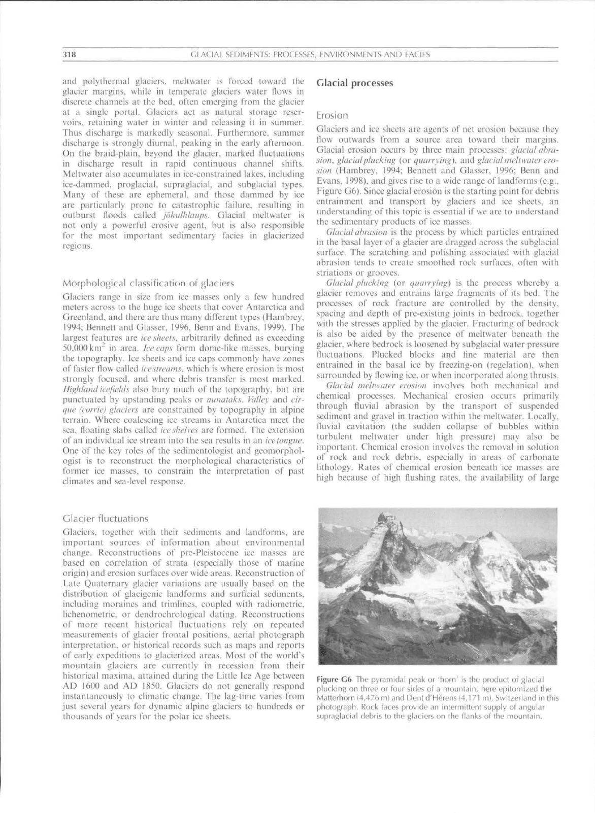
derorniation and glacier flow. Glaciers flow by one or more of
three main mechanisms: internal delormation, basal sliding,
and movcmenl over a soft, deformablc bed (Patcrson. 1994).
inlcniiil lUjornuitioii is best explained by Glen"s flow law for
poiyerystalline ice; this law relates the effective shear-strain
rate
(J:)
to shear stress
(T)
in the following equation:
J: = Ax"
where n is a eonstant, typically 3. and A depends on ice
temperature, erystal size and orientation, and impurities.
Internal deformation results in the slowest llow occurring at
ihe surface and at the base of a glacier (Figure G5). Basal
s/idiiiy is important where rain or melt-water is able to
lubricate the bed (Figure G5), and varies according to the
season and time of day or night. Frictional and geothermal
heating may add to the availability of meltwater. Many
glaciers flow over a bed of unconsolidated sediment which,
when saturated, is readily deformed. Deformable beds exist
beneath modern fast-flowing ice streams in Antarctica. Much
of ihe movement of the Quaternary ice sheets in North
America, has also been linked to subsole deformation. The
relative importance of these mechanisms is highly variable. In
moist temperate regions as much as 80 percent of glacier flow
is from sliding. Cold polar glaciers, which are frozen to their
beds,
flow almost entirely by internal deformation. Where a
deformable bed exists, the bulk of movetneni may be within
the sediment layer beneath the ice. In surgc-ivpeglaciers, flow
is unstable, uith long periods (often decades) of quiescence
punctuated by short bursts (several months to a few years) of
high velocity {surges). At its peak, the velocity may reach
several orders magnitude above normal, and the glacier may
advance rapidly, and redistribute large volumes of sediment.
Glacier structure
Glacier structures are principally the product of internal
deformation, and are intimately associated with the transport
of debris. Glacier ice is similar to any other type of geological
material in that it comprises strata that progressively deform
A
-
basal sliding component
B
-
inlernal deformation component
Figure G5 Vertical longitudinal profile through a glacier, illustrating
tht.' two miiin components of f}M ier flow, internal deform.iti()n
and basal sliding. Arrows indicate relative displacements, as
determined from borehole studies.
to produce a wide range of structures. Primary structures
include sedimentary stratification derived from snow and
superimposed ice, unconformities, and regelation layering
resulting from pressure melting and refreezing at the base of
a glacier. Secondary structures are the result of deformation,
and include both brittle features (crevasses, crevasse traces,
faults and thrusts) and ductile features (foliation, folds,
boudinage). Typically, a glacier reveals a sequential develop-
ment of structures as in deformed rocks, so that by the time the
glacier snout is reaehed. ice may reeord several phases of
deformation.
Thermal regime
The temperature distribution or ifwrmal regime of a glacier
is fundamental to glacier llow, meltwater production and
routing, and to styles of glacial erosion and deposition. The
most active glaciers are so-called it'mperiilf or warm, in which
the ice is at the pressure-melting point throughout. These
glaeiers slide rapidly on their beds and induce much erosion;
they are typical of alpine regions. At the opposite end of the
spectrum are cokl glaciers, which are below the pressure
melting point throughout. Since they are frozen to the bed,
cold glaciers are generally regarded as having little ability to
erode, although this assumption has been challenged by
observations in the Dry Valleys of Antarctica recently. An
intermediate type of glacier, found in the High-Arctic, is
referred to as pa/yihermal. In sueh glaciers, it is typieal for the
snout, margins and surface layer of the glacier to be below the
pressure-melting point, whereas thicker, higher level ice is
warm-based.
Glacier hydrology
Meltwater within, beneath and beyond glaeiers plays a vital
role in the processes of erosion and deposition. Water, derived
from melting snow and ice, flows in channels on the glacier
surface, until plunging via moulins into {he interior or bed of
the glacier, finally emerging at the snout. Drainage routes
differ according to the thermal regime of the glacier. In cold
318
C;LACIAL
SEDIMENTS: PROCESSES, ENVIRONMENTS AND EACIES
and polythermal glaciers, meltwatcr is forced toward the
glacier margins, while in temperate glaciers water flows in
discrete channels at the bed. often emerging from the glacier
at a single portal. Glaeiers act as natural storage reser-
voirs,
retaining water in winter and releasing it in sitmiiier.
Thus discharge is markedly seasonal. Furthermore, summer
diseharge is strongly diurnal, peaking in the early afternoon.
On the braid-plain, beyond the glacier, marked fluctuations
in discharge result in rapid continuous channel shifts.
Mcltwater also accumulates in ice-const rained lakes, including
ice-dammed. proglaciaL supraglacial, and subglacial types.
Many of these are ephemeral, and those dammed by iee
are particularly prone to catastrophic failure, resulting in
outburst floods ealled joktilhlaups. Glacial meltwater is
not only a powerful erosive agent, but is also responsible
for the most important sedimentary facies in glacierized
regions.
Morphological classification of glaciers
Glaciers range in size from ice masses only a few hundred
meters across to the huge ice sheets that eover Antarctica and
Greenland, and there are thus many different types (Hanibrey,
1994;
Bennett and Glasser, 1996, Benn and Evans, 1999). The
largest features are keslwets. arbitrarily defined as exceeding
50,n00knr in area. Icecaps form dome-like masses, burying
the topography. Ice sheets and ice caps commonly have zones
of faster flow ealled iccsircams. which is where erosion is most
strongly focused, and where debris transfer is most marked.
IliiihUindiccfifUis also bury much of the topography, but are
punctuated by upstanding peaks or minataks. Valley and cir-
que (corrie) glaciers are constrained by topography in alpine
terrain. Where eoaleseing ice streams in Antaretica meet the
sea. floating slabs called
ice shelves
are formed. The extension
of an individual ice stream into the sea results in an iccioiiguc.
One of the key roles of the sedimentologist and geomorphol-
ogist is to reconstruct the morphological characteristics of
former ice masses, to constrain the interpretation of past
climates and sea-level response.
Glacial processes
Erosion
Glaciers and ice sheets are agents of net erosion because they
flow outwards from a source area toward their margins.
Glacial erosion occurs by three main processes: glacial ahra-
sion.
glacial plucking (or iiuarrying). and glacial mclimiier ero-
sion (Hambrey. 1994; Bennett and Glasser. 1996; Benn and
Evans. 1998). and gives rise to a wide range of landtbrms (e,g..
Figure G6). Since glacial erosion is the starting point for debris
entrainmeni and transport by glaciers and ice sheets, an
understanding of (his topic is essential if we are to understand
the sedimentary products of ice masses.
Glacial
abrasion is the process by which particles entrained
in the basal layer of a glacier are dragged across the subglacial
surface. The scratching and polishing associated with glacial
abrasion tends to create smoothed rock surfaces, often with
striations or grooves.
Glacial plucking (or quarrying) is the process whereby a
glacier removes and entrains large fragments of its bed. The
processes of rock fracture are eonlrolled by the density,
spacing and depth of pre-existing joints in bedrock, together
with the stresses applied by the glacier. Fracturing o\' bedrock
is also be aided by the presence of meltwater beneath the
glacier, where bedroek is loosened by subglacial water pressure
fluctuations. Plucked blocks and fine material are then
entrained in the basal ice by freezing-on (regelation). when
surrounded by flowing ice. or when incorporated along thrusts.
Glacial meliwaler erosion involves both meehanical and
chemical processes. Meehanical erosion occurs primarily
through fluvial abrasion by the transport of suspended
sediment and gravel in traction within the meltwater. Loeally.
fluvial cavitation (the sudden collapse of bubbles within
turbulent meltwater under high pressure) may also be
important. Chemical erosion involves the removal in solution
of rock and rock debris, especially in areas of carbonate
lithology. Rates of chemical erosion beneath ice masses are
high because of high flushing rates, the availability oi large
Glacier fluctuations
Glaciers, together with their sediments and landforms, are
important sources of information about environmental
change. Reconstructions of pre-Pleistocene ice masses are
based on correlation of strata (espeeially those of marine
origin) and erosion surfaees over wide areas. Reconstruction of
Late Quaternary glacier variations are usually based on the
distribution of glacigenic landforms and surficial sediments,
including moraines and trimlines, coupled with radiometric.
lichenomctric, or dcndrochrological dating. Reconstructions
of more recent historical iUictuations rely on repeated
measurements oT glacier fiontal positions, aerial photograph
interpretation, or historical records such as maps and reports
of early expeditions to glacierized areas. Most of the world's
mountain glaciers are currently in recession from their
historical maxima, attained during the Little Ice Age between
AD 1600 and AD 1850. Glaciers do not generally respond
instantaneously to climatic change. The lag-time varies from
just several years for dynamic alpine glaciers to hundreds or
thousands of years for the polar ice sheets.
Figure G6 The |j}i"diiiiiljl peak ur
iiorn'
ib llic produti ol gljuJdl
plu(
kirij^
on three or four sides of
<i
mountain, here epitomized the
Malterhorn (4,476 ni) and Dent d'Herens
(4,1 71
m|, Switzerland in this
phulugraph. Ruck foces provide an intermittent supply of angular
lidl debris to the fjLiciers on the flanks of the mountain.
GLACIAL SEDIMENTS: PKOCES.SES, ENVIRONMENTS AND EACIES
319
amounts of chemically-reactive rock flour, and the enhanced
solubility of CO: iit low temperatures.
To these three main processes we may add a fourth: the
relatively poorly understood process of suhglacial sctlinicni
dcformalion. Sediment deformation beneath ice sheets con-
tributes to glacial erosion wherever there is a net removal o\
material from the bed durina sediment deformation (Boulton,
1996).
Debris entrainmeni and transport
It is widely recognized that debris is incorporated mainly at the
bed and on the surface of a glacier, and that the transport
paths and textural character of glacial sediments are related to
ihe dynamic and thermal characteristics of the glaeier. In
general terms, polythermal glaciers tend to carry a high basal
debris load, and ihcir surfaces rarely have a substantial cover
of debris. In contrast, temperate glaciers, especially those in
alpine terrain, nortnally carry little debris at the bed. but their
surfaces commonly have extensive areas of supraglacial debiis.
The resulting sedimentary products can thus be used to infer
the thermal and topographic regimes of the glacier.
The entrainment of debris at the bed, by a combination of
pressure melting and refree/ing (regelation). to create a basal
debris layer is well-known from studies of both temperate and
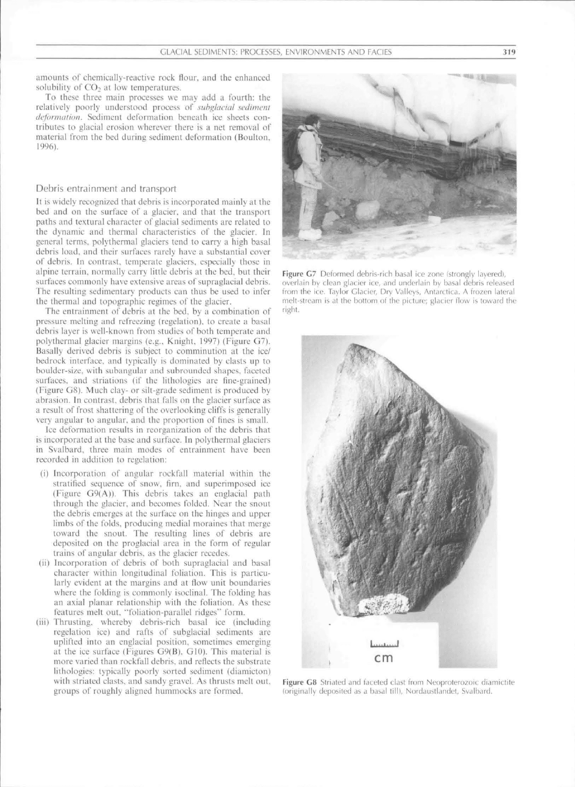
polythermal glacier margins (e.g,. Knight. 1997) (Figure G7).
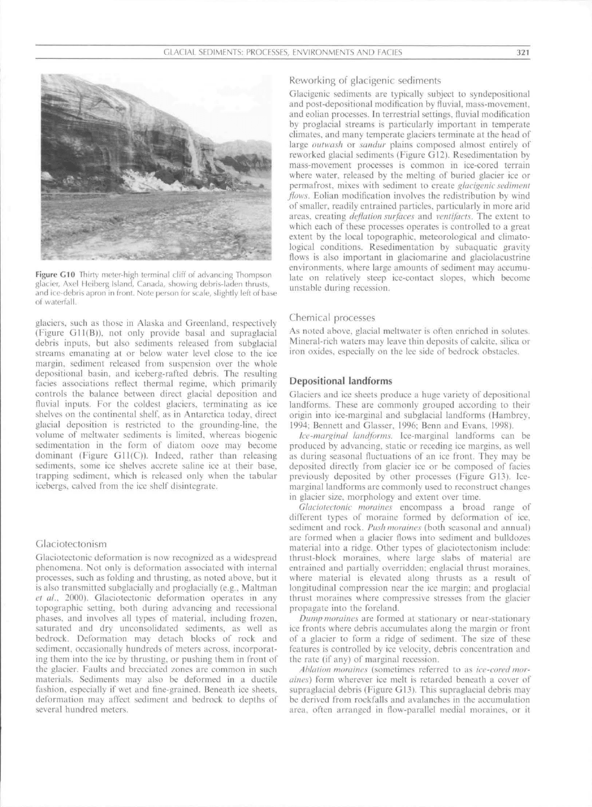
Basally derived debris is subject to comminution at the ice/
bedroek interfaee, and typieally is dominated by clasts up to
boulder-size, with subangular and subrounded shapes, faeeted
surfaces, and striations (if the lithologies are fine-grained)
(Figure G8). Much clay- or silt-grade sediment is produced by
abrasion. In contrast, debris that falls on the glacier surface as
a result of frost shattering of the overlooking cliffs is generally
very angular to angular, and the proportion of fmes is small.
Ice deformation results in reorganization of the debris that
is incorporated at the base and surfaee. In polythermal glaciers
in Svalbard, three main modes of entrainment have been
recorded in addition to regelation:
(i) Incorporation of angular rockfall material within the
stratified sequence of snow, firn, and superimposed ice
(Figure G9(A)). This debris takes an englacial path
through the glacier, and becomes folded. Near the snout
the debris emerges at the surface on the hinges and upper
limbs of the folds, producing medial moraines that merge
toward the snout. The resulting lines of debris are
deposited on the proglacial area in the form of regular
trains of angular debris, as the glaeier recedes.
(ii) Incorporation of debris of both supraglacial and basal
character within longitudinal foliation. This is particu-
larly evident at the margins and at flow unit boundaries
where the folding is commonly isoclinal. The folding has
an axial planar relationship with the foliation. As these
features melt out. "foliation-parallel ridges"" form.
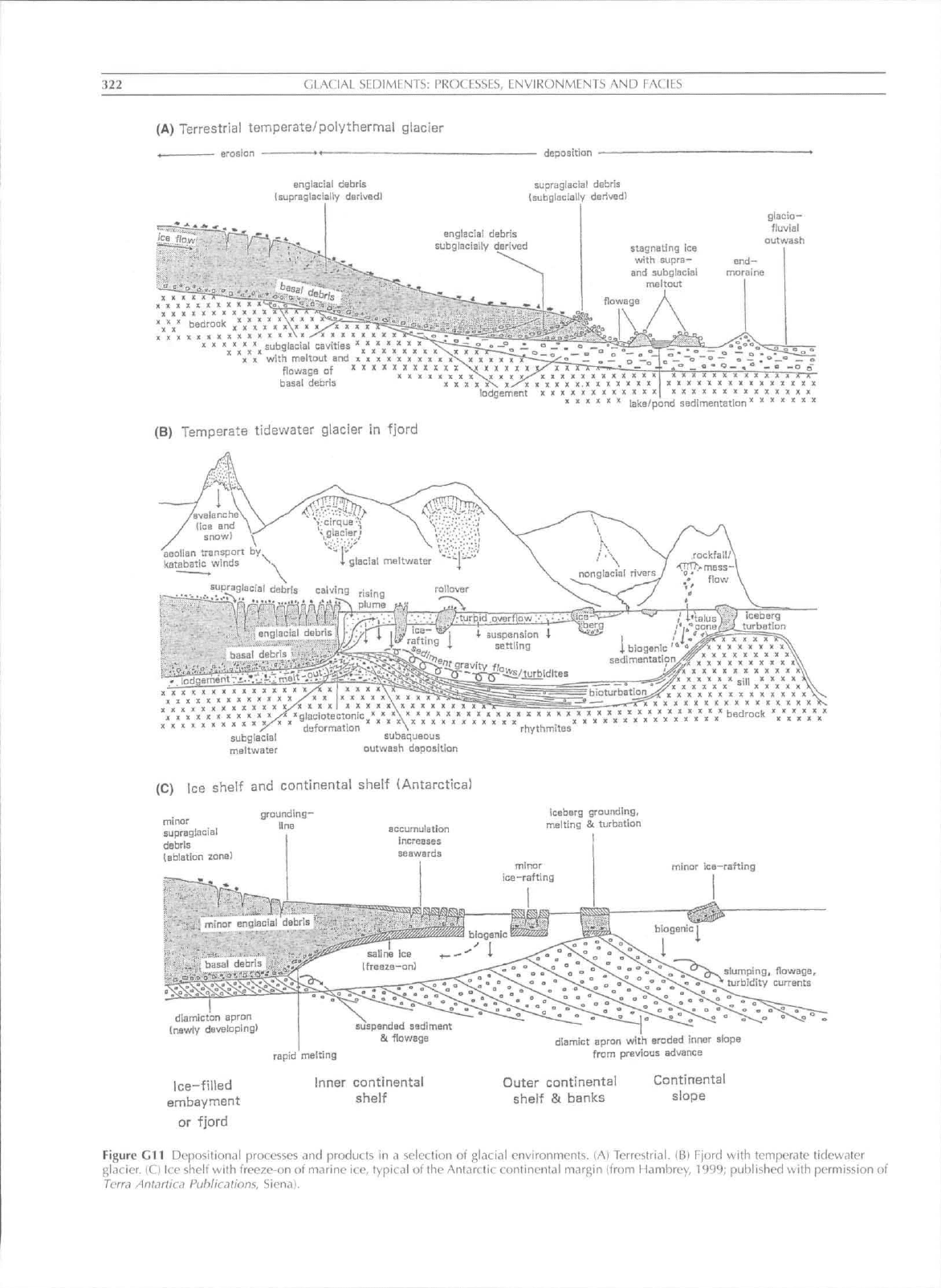
(iii) Thrusting, whereby debris-rich basal ice (including
regelation ice) and rafts of subglacial sediments are
uplifted into an englacial position, sometimes emerging
at the ice surface (Figures G9(B), GIO). This material is
more varied than rockfall debris, and reflects the substrate
lithologies: typically poorly sorted sediment (diamicton)
with striated clasts, and sandy gravel. As thrusts melt out,
groups
ci\'
roughly aligned hummocks are formed.
Figure C7 Deformed debris-rich basal ice zone (strongly layered),
overlain by clean glacier ice, and underlain by basal debris released
from the ice, Taylor Glacier, Dry Valleys, Antarctica. A frozen lateral
melt-stream is at the bottom of the picture; f^Jacier flow is lovvard the
right.
cm
Figure GS Striated and faceted clast from Neoproterozoic diamictite
{originally deposited as a basal
lilll,
Nordaustl.indet. Svalbard.

320 GLACIAL SEDIMENTS; PROCESSES, ENVIRONMFNTS AND FACIES
PUN
CROSS - SECTION
stratification witli/without
rockfall debris
supragiaciai debris
debris layer
from rockfall
basal debris
supragiacial debris
(medial moraines)
(B)
snout
Cross-section of snout area
basally-derived
supragiacial
debris \
sandy diamicton
gravel
i
basal d§collement
proglacial landform/
sediment assemblage
basal
debris
englacial landform/
sedinnent assemblage
(T) = thrust
Figure G9 Conceptual models of debris enlrtiinment. lA) Folding ot supraglatial debris wilh stratified ice and of basal debris as a result of
converging flow from multiple accumulation basins (simplified from FHambrey e(
nL,
1999). (B) Thrusting of basal, subglactal, and proglacial
debris in a polythermal glacier as found in the maritime High-Arttic (aficr Hambrey et
al.,
1997).
Of these mechanisms, only thrusting is well-known from
temperate glaciers, but usually the amount of debris involved is
insufficient to leave a landform imprint. The other mechanisms
are likely to exist in temperate glaciers, but have not yet been
documented, although it is well-known that shearing at the
margins of alpine valley glaciers, and at the confluenees of two
flow
units,
incorporate debris.
Deposition
Glacial deposition involves the release of debris that has been
transported on or within glacier ice. Debris is modified during
transport primarily by basal processes (e.g.. abrasion and
quarrying during intra-clast eollision. subglaeia! sediment
deformation), and by water in subglacial. englacial. and
supragiacial stream channels. Debris that follows a passive
transport path (supraglaeially or cnglacially) tends to retain its
primary characteristics.
Sediment may be deposited direetly beneath the glacier or at
its margins, or it can be transported significant distances from
the glacier itself by other agents such as rivers or by iceberg
calving. During release from the ice. numerous glacier-related
processes, including reworking in marginal streams and lakes,
debris flows and eolian activity, may modify sediment. Many
glaeigenic sediments may be related to specific glacial
environments. For example, the temperate terrestrial glacier
system is commonly regarded as being dotninated by a mixture
of basal (actively transported} and supragiacial (passively
transported) sediment, with a strong element of giaciofiuvia!
modification upon release (Figure Gll(A)), Glaciers termin-
ating in iiords produce a facies association that is also
dependent on thermal regime. Temperate and polythermal
GLACIAL SEDIMENTS; PKOCFSSES, FNVIRONMFNTS AND FACIES
321
Figure GIO Ihirty mfler-high terminal cliff of advancing Thompson
gkicier, Axel I leiberj; Isl.mrl, Canada, showing debris-laden thrusts,
and ictf-dt'bris ^ipron in
Ironl.
Note person for
scale,
slightly left of base
of waterfall.
glaciers, such as those in Alaska and Greenland, respectively
(Figure Gll(B)). not only provide basal and supraglacia!
debris inputs, but also sediments released from subglacial
streams emanating at or below water level close to the ice
margin, sediment released from suspension over the whole
depositional basin, and iceberg-rafted debris. The resulting
lacies associations relicct thermal regime, which primarily
controls the balance between direct glacial deposition and
lluvia! inputs. For the coldest glaciers, terminating as ice
shelves on the continental
shelf,
as in Antarctica today, direct
glacial deposition is restricted to the grounding-line, the
volume of meltwater sediments is limited, whereas biogenic
sedimentation in the form of diatom ooze may become
dominant (Figure Gll(C)). Indeed, rather than releasing
sediments, some ice shelves accrete saline ice at iheir base,
trapping sediment, which is released only when the tabular
icebergs, calved from the ice shelf disintegrate.
Glaciotectonism
Glaciotectonic deformation is now recognized as a widespread
phenomena. Not only is deformation associated with internal
processes, such as folding and thrusting, as noted above, but it
is also transmitted subglacially and proglacially (e.g.. Maltman
ct ai. 2000). Glaciotectonic deformation operates in any
topographic setting, both during advancing and recessional
phases, and involves all types of material, including frozen,
saturated and dry unconsolidated sediments, as well as
bedrock. Deformation may detach blocks of rock and
sediment, occasionally hundreds of meters across, incorporat-
ing them into the ice by thrusting, or pushing them in front of
the glacier. Faults and brecciated zones are common in such
materials. Sediments may also be deformed in a ductile
fashion, especially if wet and fine-grained. Beneath ice sheets,
deformation may affect sediment and bedrock to depths of
several hundred meters.
Reworking of glaeigenic sediments
Glaeigenic sediments are typically subject to syndepositional
and post-depositional modification by tluvial. mass-movement,
and eolian processes. In terrestrial settings, tluvial modification
by proglacial streams is particularly important in temperate
climates, and many temperate glaeiers terminate at the head of
large ouiwash or sandur plains composed almost entirely of
reworked glacial sediments (Figure GI2). Reseditnentation by
mass-movement processes is common in ice-cored terrain
where water, released by the melting o'i buried glacier ice or
permafrost, mixes with sediment to create
i^hicigenic
sediment
flaws. Eolian modification involves the redistribution by wind
of smaller, readily entrained particles, particularly in more arid
areas,
creating i/eflaiion surfaces and ventijiicis. The extent to
which each of these processes operates is controlled to a great
extent by the local topographic, meteorological and climato-
logicai conditions. Resedimentation by subaquatic gravity
flows is also important in glaciomarine and glaciolacustrine
environments, where large amounts of sediment may accumu-
late on relatively steep ice-contact slopes, which become
unstable during recession.
Chemical processes
As noted above, glacial meltwater is often enriched in solutes.
Mineral-rich waters may leave thin deposits of calcitc, silica or
iron oxides, especially on the Ice side of bedrock obstacles.
Depositional landforms
Glaciers and ice sheets produee a huge variety of depositional
landlbrms. These are commonly grouped according to their
origin into ice-marginal and subglacial landfonns (Hambrey.
1994:
Bennett and Glasser. 19%; Benn and Evans. 1998).
lee-marginal landforms. Ice-marginal landforms can be
produced by advancing, static or receding ice margins, as well
as during seasonal fiuctuations of an ice front. They may be
deposited directly from glacier ice or be composed o\' facies
previously deposited by other processes (Figure G13). Ice-
marginal landforms are commonly used to reconstruct changes
in glacier size, morphology and extent over time.
Glaciolcctonlc moraines encompass a broad range of
different types of moraine formed by deformation of ice,
sediment and rock. PushnnmiiiK's (both seasonal and annual)
are formed when a glacier flows into sediment and bulldozes
material into a ridge. Other types of glaciotectonism include:
thrust-block moraines, where large slabs of material are
entrained and partially overridden: englacial thrust moraines,
where material is elevated along thrusts as a result of
longitudinal compression near the ice margin; and proglacial
thrust moraines where comprcssive stresses from the glacier
propagate into the foreland.
Dump moraines are formed at stationary or near-stationary
ice fronts where debris accumulates along the margin or front
of a glacier to fortn a ridge of seditnent. The size of these
features is controlled by ice velocity, debris concentration and
the rate (if any) of marginal recession.
Ablation moraines (sometimes referred to as ice-cored mor-
aines) form wherever ice melt is retarded beneath a cover of
supragiacial debris (Figure G13). This supragiacial debris may
be derived from rockfalls and avalanches in the accumulation
area, often arranged in flow-parallel medial moraines, or it
322
GLACIAL SEDIMFNTS: PROCESSES, ENVIRONMENTS AND FACIFS
(A) Terrestrial temperate/polythermal glacier
deposition
englaclal debris
(supraglaclaliy derived)
supragiacial debris
Isubniaciaily derived)
englaciai debris
subglacially derived
stagnating
ice
with supra-
end—
and subglacial moraine
me
I
tout
glacio-
tluvial
out wash
^
" \\ X
X
="'^3'^'^'^'
"^'*'^^
X X X X X X X x\x X
X
X
with meltout
and
nxxxxxxxxx
flo\Aiaga
of
basal debris
(B) Temperate tidewater glacier
in
fjord
lodgement
lake/pond sedimentation
X
X X X X X X
X
X « S
X
« X I I <
XXKXXXXXXX
XXXIXXXXXX
subaqueous
outwash deposition
(C) Ice shelf and continental shelf (Antarctica)
iceberg grounding,
melting
5
turbation
slumping,
flowage
turbidity currents
dl.
(newly developing!
ice-filled
embay ment
or fjord
rapid melting
diamict apron with eroded inner slope
from previous advance
Inner continental
shelf
Outer continental
shelf
a
banks
Continental
slope
Figure
Gil
Depositional processes and products
in a
selection
of
glacial environments.
lA)
Terrestrial.
(B)
Fjord with temperate tidewater
glacier.
IC) ke
shelf with treeze-on
of
marine ice, typical
of
the Antarctic conlinentcal marj;in (from Hambrey, 1999; published with permission
of
Terra Antartic<i
Fuhlicjtions, Siena).

GLACIAL SFDIMKNTS: PROChSSFS, HNVIKONMENTS AND FACIES
323
Figure G12 lir,3irled river system emanating from debris-tovered Casement Glacier
(leitl,
southern Aldskj. Small pits on the outwash
.ire kettle holes iirising trom slow meltinj^ ot' buried ite blocks.
Figure C13 ttemar^innl l.incltorms, espet iaily altldtion niordirie, toniprising
.1
mixture' ot'
Vadret cUi Mortertitsch, SwitzerUnd.
itilly ^ind basdily derived deljris,
324
GLACIAL SEDIMENTS: PROCESSES, ENVIRONMENTS AND EACIES
may be composed of subglacial or englacial debris elevated to
the ice suriace by folding, thrusting or upward-directed flow
lines in the ablation urea. If the cover of insulating debris is
irregular, as is commonly the case, irregular ridges and
mounds of debris, often known as hummocky momiiu's, will
develop as ablation proceeds. Although initially large and with
a pronounced morphology, ablation moraines reduce drama-
tically in size as the ice-core melts and material is subject to
debris flowage.
Ouiwash funs and outwa.Hhplains (or saiuhir. plur: saiulur.
sing.) are formed as glacial meitwater emerges from the glacier
and sediment is deposited at or beyond the ice margin.
Outwash fans form at stationary ice margins where mellwater
is concentrated at a particular point for a length of time.
Outwash plains are much larger features, formed where
individual fans merge away from the glacier to create a
braided river facies association (Figure GI2). Characteristics
of the glaciofluvial environment are braided river channels
with rapidly migrating bars, terraees, frequent ehannel
avulsions and the formation of kellle holes where sediment is
deposited over buried ice.
Kame terraces are Ibrmed when sediment is deposited by
meltwater flowing laterally along an iee margin. Kumes are
more fragmentary features, formed in a similar manner, but
often in iee-walled tunnels and against steep valley sides.
Kcimi'-anii-keitle lopogiaphy is the term used to describe the
landform-sediment assemblage often found on glacier fore-
fields where there was formerly a high proportion of buried ice.
Suhglacidl
Iciniljorins
(sometimes referred to as suhglcicial
hedforms) are produced beneath actively flowing iee. They
provide information about former subglaeial conditions,
including ice-flow directions, thermal regime and paleohydrol-
ogy. The most common of these is a family of ice-molded
iandlbrms, all ol which are parallel to ice-flow. Fluies are low
(typically <3m), narrow (<3m). regularly spaced ridges that
are rarely continuous for less than lOOni. Megtifluics are taller
(>5ml. broader and longer (>l()()m) than flutes. Mcga-scale
lineaiiiiiis are much larger (tens of kilometers in length and
hundreds of meters in width) that are often only visible when
viewed on satellite imagery. Drumlins are typically smooth,
oval-shaped or elliptical hills composed of a variety of
glacigenic sediments. They are generally between
5
m and
5()ni high and lOm to 3,000m in length. Drumlins normally
have lengih-to-width ratios of less than 50. Their steeper, blunt
end often faces up-ice and they are often found in large groups
known as dnimlin
.swarms.
The origin of drumlins is unclear.
but they have been ascribed to subglacial deformation, to
lodgement, to the melt out of debris-rich basal ice and to
subglacial sheet floods.
Rihhedmoraines (also known as Rogen moraines) are large,
regularly and closely spaced moraine ridges eonsisting of
glaeigenie sediment. They are often curved or anastomosing,
but their general orientation is transverse to ice flow. They
often show drumlinoid elements or superimposed fluting.
Ribbed moraines may represent the fracturing of
a
pre-existing
subglacial till sheet at the transition from cold- to warm-based,
presumably during deglaciation.
Geometric ridge networks and crexasse-fill ridges are sub-
glacial landforms that arc not generally ice-molded. These
features, composed of subglacia! material, are low (l-3m
high) ridges that, when viewed in plan, show a distinct
geometric pattern. The traditional explanation for these
features is that they form by the squeezing of subglacial
material into basal crevasses or former subglacial ttinnels,
eommonly during surges. Alternatively, geometric-ridge net-
works also form beneath glaciers as a result of the intersection
of foliation-parallel ridges and englacial thrusts.
Eskers are glaciofluvial landforms created by the flow of
meltwater in subglaeial. englacial or supragiacial channels.
They are usually sinuous in plan and composed of sand and
gravel. Some eskers are single-crested, whilst others are
braided in plan. Concertina eskers are deformed eskers, created
by compression beneath overriding ice.
Bathymetric forms resulting from glacial processes
Erosional forms
Various erosional phenomena, mainly associated with
grounded ice or subglacial meltwater are found in marine
settings. The larger scale forms arc tilled by sediment and may
be recognizable in seismic profiles (e.g., Anderson. 1999).
Suhnuirine troughs are found on continental shelves, and are
genetically equivalent to fiords and other glacial troughs, but
are generally much broader. The largest occur in Antarctica
where they attain dimensions of over 400 km in length, 200 km
in width and 1.100 m in depth. They are formed by ice streams
and, where two streams merge, an
ice-.srream
boundary
ridge
is
formed. Steep-sided channels a few kilometers wide, carved
out by subglacial meltwater and subsequently tilled by
sediment, are known as tunnel
valleys.
These are well-known
from the NW European continental shelf around Britain, the
Scotian Shelf off Canada, and in Antarctica. Icebergs can also
cause eonsiderable erosion as they become grounded on the
seafloor. Large tabular bergs ean seour the bed of the sea for
several tens of kilometers, leaving impressions up to lOOm
wide and several meters deep. Slope valleys are groups of
gullies forming a dendritic pattern, and develop just beyond
the ice margin, on the continental slope, as a result of erosion
by sediment gravity flows emanating from sediment that
accumulated at the ice margin. On continental shelf areas.
where the iee repeatedly becomes grounded, and then releases
a large amount of rain-out sediment, alternations of diamicton
and boulder pavements may be observed. The pavements build
up by accretion of boulders around an obstaele, by subglacial
erosion, or as a lag deposit from winnowing by bottom
currents.
Depositional forms
The morphology and sediment composition of subaquatic
features, particularly in fjords and on continental shelves are
less well-known than their terrestrial counterparts, but major
strides have been made in identifying such features in the last
two decades. As on land, depositional assemblages reflect the
interaction of a wide range of processes.
Ice-contact features form when a glacier terminus remains
quasi-stationary in water, particularly in tiords (Powell and
Alley. 1997) (Figure G14). Morainal hanks form by a
combination of lodgement, meltout, dumping, push and
squeeze processes, combined with glaciofluvial discharge:
poorly sorted deposits arc typical of such features. Ground-
ing-line fans extend from a subglacial tunnel that discharges
meltwater and sediment into the sea. and are typically
composed of sand and gravel. Developing out of grounding-
line tans are ice-eontact deltas that form when the terminus