Marjoribanks R. Geological Methods in Mineral Exploration and Mining
Подождите немного. Документ загружается.


88 6 Rotary Percussion and Auger Drilling
greywacke, etc.) can be recorded in a separate column of the log sheet. Other
attributes commonly recorded are percentage quartz or sulphide, degree and type
of alteration, structures seen within the chips such as foliation, degree of oxidation,
depth to water table and so on. A separate column s hould also be provided on the
log sheet for verbal comments.
The detailed rock description refers only to the larger fragments recovered from
the hole. Since these represent only the harder and more competent parts of the
section drilled, it is important that a separate column record the estimated percentage
of washed cuttings to fines. Thus 50% quartz vein fragments observed in the coarse
washed portion of an interval where 50% of the total recovered cuttings consisted
of fines, will probably equate to only 25% quartz vein material intersected in that
interval.
The spread-sheet logging form can be readily created in a standard software pro-
gram, such as Excel. The observations can then be entered directly, as they are made,
into a battery-powered notebook or palmtop computer at the drill site.
2
The full
range of possible observations in each descriptive category can be pre-printed along
with a bar code on to standard laminated sheets. Data entry with a bar-code reader
is then quick and simple. At the end of the day, or the end of the programme, the
completed logs can then be downloaded from the field computer to a desk-top PC
for storage, handling and plotting on section by one of the many exploration data
software programs that are commercially available. It should be emphasized, how-
ever, that even where data are recorded electronically in this way, the geologist still
needs to hand-plot the geology of the hole on to a section as drilling proceeds, as
described above.
RC holes can deviate substantially from their starting azimuth and inclination.
Holes that are targeted on ore, and are much more than 50 m deep, need to be
surveyed as described in Sect. 7.9.
6.1.1.2 Display and Storage of Cuttings
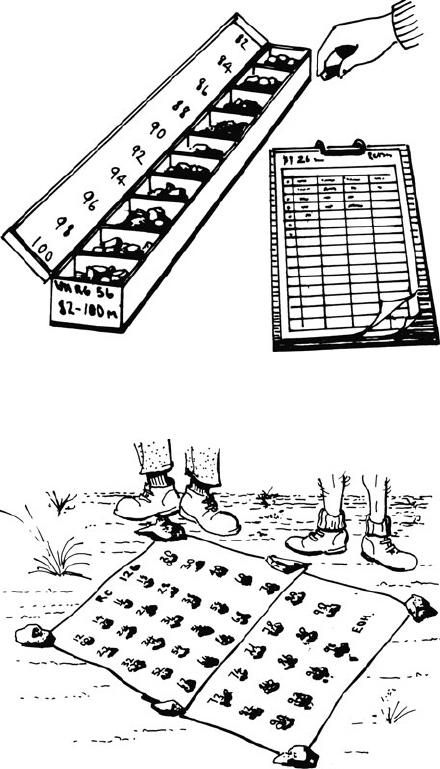
The washed and sieved drill cuttings should be permanently stored in segmented,
plastic cuttings boxes for later, more leisurely examination, should that prove
necessary (Fig. 6.2).
In addition to this permanent storage, it is often a good idea to lay out samples
of the washed cuttings from the entire hole on to a plastic sheet (a large sample
bag is ideal) spread on the ground beside the collar of the drill hole (Fig. 6.3). The
sequence of rocks through the entire hole can then be seen at a glance, and it is easy
to spot progressive down hole changes. If the samples are left on display like this
for the duration of the drilling programme, comparing intersections and establishing
correlations between adjacent holes is made very much easier.
2
Waterproof and dustproof protective covers are available for palm-top computers and make this
system very practical.
6.1 Rotary Percussion Drilling 89
Fig. 6.2 Permanent storage of washed drill cuttings in a compartmented cuttings box
Fig. 6.3 Temporary field display of washed cuttings. Samples from each interval are laid out on
a plastic sheet (sample bags) near the drill collar. This aids in identifying down-hole changes and
permits quick and easy comparisons between adjacent holes in the course of a drilling program
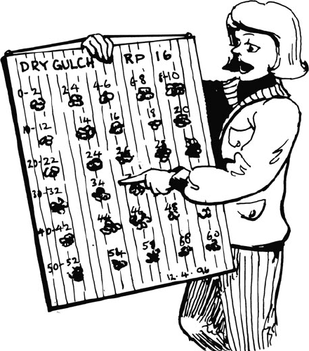
With particular holes that are considered to be representative of a geological
environment, the washed cuttings can be glued on to a suitably labelled cuttings
board (Fig. 6.4). When displayed in this manner, it is easy to carry the board to
site to act as a reference for future logging. A cuttings board is also invaluable
for communicating the results of a drilling programme, and for helping to train
geologists coming into an established project to ensure consistency of geological
description.
90 6 Rotary Percussion and Auger Drilling
Fig. 6.4 A permanent display of washed cuttings. Cuttings from a typical hole or section are glued
to suitably labelled board. The board can then be used as a reference for future logging, to maintain
consistency of description between geologists, or for presentations
6.1.1.3 Sampling
The total amount of cuttings from each drilled interval is collected from the cyclone
in a large polythene or polyweave bag (Fig. 6.1). Despite all precautions, it is usually
impossible to avoid some sample loss – often fine dust or mud.
Conversely, in some cases, because the hole can locally “chamber out” below the
ground, some intervals drilled will yield more sample volume than would otherwise
be expected. Such variations affect the usefulness of the assay for that interval, and
while this may not matter too much in reconnaissance drilling, it is obviously a
serious problem in drilling out any mineralization. In detailed drilling, where sample
loss (or gain) is suspected, the total material from each metre of advance should be
routinely weighed and the weight recorded on the log form. Assays from intervals
with significant sample loss or gain from the standard will obviously need to be
treated with caution.
Cuttings from a one metre interval will normally weigh 25–30 kg. A represen-
tative split of the cuttings will therefore have to be made in the field to provide
a sample for assay. Two methods of collecting this sample are commonly used
(Barnes, 1987):
6.1 Rotary Percussion Drilling 91
1. Pipe sampling: The bag of cuttings is thoroughly mixed by rolling and agitating
the bag. Collecting a sample from the bag is done with a plastic pipe approxi-
mately 80 cm long, an internal diameter of around 6 cm and cut at an angle at
one end. With the bag on its side, the pipe is inserted lengthways and rotated as
it is pushed in (take care not to punch a hole in the bag!). Three pipe samples are
collected parallel to the long axis of the bag, and two pipe samples diagonally
across the bag. The five pipe samples are then combined to form the combined
sample to be sent for assay. After collecting the combined sample, the pipe is
thoroughly cleaned, both inside and outside, with a rag.
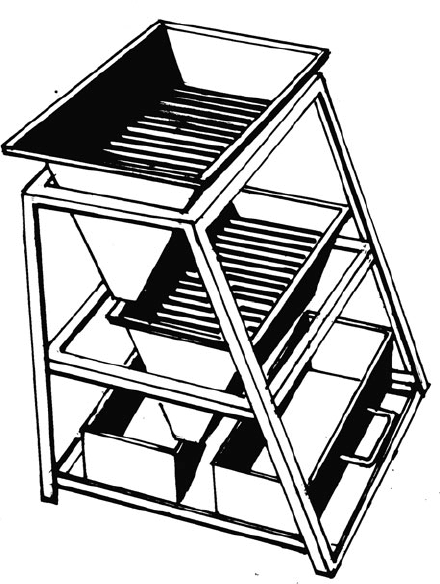
2. Splitting: Riffle splitters, such as that illustrated in Fig. 6.5, provide probably
the most effective split of a sample but the procedure is more laborious and time
consuming than the pipe sampling described above. Effectively cleaning a multi-
stage riffle splitter between each sample can also be a tedious process, especially
if the sample is damp. A compressed air line (if available from the drill rig)
Fig. 6.5 A two-stage riffler splitter. This model will split a large volume RC drill sample in the
ratio 3:1. The small portion is sent for assay. The large portion is bagged and retained for possible
future check assays

92 6 Rotary Percussion and Auger Drilling
provides the most effective way of cleaning the splitter between samples. For
accurate sampling within a mineralized zone, especially in gold prospects where
nugget problems are suspected, the use of a riffle splitter is mandated.
3
3. Checking: For effective quantification of error both in s ampling and laboratory,
the routine use of duplicate and standard samples is recommended. It is good
practice to include at least one duplicate and one standard sample (i.e. one whose
metal content is known within a certain specified range): such samples with var-
ious assay ranges for different elements can be purchased – in every batch of 20
samples sent to the laboratory.
6.1.1.4 Sampling Below the Water Table
An RC rig can provide a useful sample from below the water table, provided the
water flow is not too high. However, some contamination of the sample is inevitable,
and for this reason RC drilling should not be considered in these conditions when
detailed drilling is being undertaken to establish ore reserves.
For drilling below the water table, it is necessary to use a large rig with high air
pressure, a sealed hole and a face-sampling bit.
4
The recovered sample will be wet
and so generally cannot immediately be split for assay. It is recommended that the
sample be collected in a large calico or polyweave bag (say 80 × 50 cm) that is left
open. In 3 or 4 days of dry weather, most of the water will have evaporated through
the weave and pipe sampling can then be carried out as described above. If large
amounts of water are present, it may be necessary to collect the wet slurry sample
into large plastic buckets (100 l garbage bins have been used) and allow it to settle.
The settling of fine material can be speeded up by the addition of a flocculant. This
procedure is undoubtedly tedious but, as the only other alternative to collecting a
useable sample in these conditions is diamond drilling, it may be worth considering
in some cases.
For assessment of mineralization below the water table, the appropriate technique
is to use diamond drilling, particularly diamond tails on the end of the RC holes.
6.1.1.5 Capping and Marking the Hole Collar
All drill holes must be sealed and permanently marked at the completion of the
drill program. Sealing holes is particularly important for large diameter RC holes. It
ensures that dirt and stones cannot fall down the hole (you might want to return with
3
Some drilling companies provide a multi-stage splitter, attached directly to the cyclone, that pro-
duces a 1/8–7/8 split for assay sample and retained cuttings. These splitters are designed to be
quickly and simply cleaned by a built-in vibrator and compressed air hose. This set up can offer
quick convenient sampling, but needs to be checked constantly for the effectiveness of the cleaning
process.
4
With a face sampling bit the cuttings pass into the inner tube through a hole in the face of the drill
bit. With normal bits (such as illustrated in Fig. 5.2) the cuttings pass into the inner tube through
openings (called a cross-over sub) located immediately behind the drill bit.

6.1 Rotary Percussion Drilling 93
a rig and re-enter one day) and animals cannot be injured. A prominent permanent
marker also means that the hole collar can be easily relocated and identified, even
after many years. RC hole collars should be sealed and marked in the same way as
described for diamond drill collars (see Sect. 7.12 and Fig. 7.25).
6.1.2 Air Core Drilling
Air core is a specialized RC drill procedure where a small annular bit is used to cut
a solid core of rock from relatively soft or easily broken material. The bit produces
short sections of core which are recovered, along with broken rock chips, up the cen-
tre of the drill stem in the manner of a standard RC rig. The system is often capable
of penetrating and coring soft sticky clays which might bind a normal blade bit.
6.1.3 Rotary Air Blast (RAB) Drilling
6.1.3.1 Drilling Technique
RAB drill rigs are light weight truck mounted rotary percussion machines that
recover cuttings to surface through pumping compressed air down the centre of
the drill stem. Cuttings pass to the surface up the outside of the rods and spill onto
the surface where they are usually collected in a tray notched to fit around the drill
stem, although a cyclone may be employed for collection in the same manner as an
RC rig. The rigs are used as a geochemical sampling tool to quickly drill shallow
holes (up to 60 m depth) in weathered rocks.
To obtain high-quality geochemical samples with as little environmental dis-
turbance as possible, it is recommended that the following basic procedures be
followed:
• The driller should ensure that the air pressure used is just sufficient to lift the
cuttings from the hole and not blow them into the air.
• The air used can be moistened to reduce the dust levels.
• The driller should clear the cuttings from the drill stem between samples and on
each rod change by means of blowback.
• All holes should be capped on completion. Plastic seals, which can be inserted
into the hole to retain a plug of earth that is tamped down on top of them, are
available commercially.
5
5
But you can make your own: a wedge-shaped concrete plug can be easily made using a plastic
garden flower pot as a mould. A short length of garden hose or black poly pipe inserted i nto
the wet concrete provides a convenient handle for the solidified plug. Making a supply of such
plugs is a useful occupation for technical assistants during the inevitable “flat” spots of exploration
programmes – such as a rig break down or the arrival of the wet season.

94 6 Rotary Percussion and Auger Drilling
6.1.3.2 Geological Logging
A limited amount of geological information can be obtained from RAB cuttings
and they should be routinely logged. Because of the speed with which drilling can
sometimes take place (over 1,000 m a day is not uncommon when drilling shallow,
close-spaced holes), detailed logging is often not possible. However, it is important
to record the weathering profile down each hole so as to understand the significance
of the geochemical results, and a bedrock lithology identification helps build up a
subsurface geological map. A description of the vertical profile through the regolith
section and a bottom-of-hole bedrock lithology descriptor should therefore, as a
minimum, be made routinely for each hole.
As with other types of drilling, the geologist should attempt to keep up with the
drill rig in his or her logging, and although there may not always be enough time
to plot results on to a map or section as drilling proceeds, it is still important to be
aware of the geology being defined by the drilling as it proceeds. In some cases this
may lead to a decision to modify the planned programme or to ideas being generated
which will lead to particular features being sought in the cuttings.
Recording the observations is similar to RC drill logging. The log sheet is drawn
up in to rows representing the metre advances, and columns for each attribute that
it is desired to record. When describing vertical profiles through the regolith, the
colour, grain size and texture of the cuttings are important descriptors. Make use
of Munsell
R
soil colour charts
6
for scientifically defined colour words, and avoid
such subjective terms as “chocolate brown”, “brick red”, “khaki” etc. (chocolates,
bricks and khakis, after all, come in many shades).
Many of the attributes of the cuttings can be recorded by a system of abbrevia-
tions, or by code numbers and letters. The identification of the rock chip – if one
can be made – should be kept for a separate entry on the log.
The rows and columns of the log sheet represent a spread-sheet and can be cre-
ated on standard spread-sheet software. The logging can then be done directly into
a suitably protected notebook or palm-top computer at the drill site. Data can be
entered by key-stroke or by using a bar-code reader (Sect. 6.1.1). When convenient,
the data can then be downloaded to a larger PC for storage, processing or plotting
with one of the many exploration data software packages that are available.
The bottom-of-hole washed sample should be stored in plastic cuttings boxes
(Fig. 6.2). As described in the section on RC drilling, display of representa-
tive cuttings from the hole either on plastic sheets laid on the ground beside the
hole (Fig. 6.3), or by gluing to a cuttings board (Fig. 6.4), can greatly facilitate
establishing correlations between holes. More detailed logging of the cuttings can
subsequently be made from the stored sample if necessary.
6
Munsell
R
soil and rock charts are a commercial system for objective, repeatable scientific colour
description in terms of three attributes – value (lightness/darkness), hue (colour) and chroma
(strength). The charts allow matching the sample to a series of printed colours that cover the range
of normal soils and rocks.
6.1 Rotary Percussion Drilling 95
6.1.3.3 Sampling
In the past, a common method of sampling was to grab sample the cuttings from
the hole where it intersected bedrock. The danger of this procedure was that the
bottom-of-hole sample could have come from a zone of metal depletion. However,
sampling every drilled interval can often be prohibitively expensive. For reconnais-
sance drilling of gold prospects in weathered terrain, it is therefore recommended
that the entire drill hole be sampled by means of composite sampling. Composite
sampling takes advantage of the ability of modern assay methods to detect very
low levels of gold, and the enhanced concentrations of gold and related indicator
elements that can occur in different parts of the weathering profile.
Composite sampling can be accomplished by means of either grab sampling or
pipe sampling.
With grab sampling, cuttings for each advance of the drill (usually 2 m) are
placed on the ground and a sample is taken by running a trowel lengthways through
the spoil heap. Samples from several spoil heaps constitute the composite sample.
The main advantages of this method are that it is quick and relatively cheap and
the cuttings can be laid directly on to the ground without bagging. The main dis-
advantage is that the heaps rapidly coalesce and disperse, especially if subjected
to rain, and it can sometimes be difficult or impossible to subsequently carry out a
more detailed sampling of the hole. It is also easy when sampling in this manner to
contaminate the sample with surface material, and, of course, the reverse can also
be true. For environmental reasons it is usually important to ensure that the surface
material is not contaminated by the sample.
An alternative method is to bag all the cuttings for an advance of the drill, and to
sample the bag using pipe sampling in the manner more fully described under RC
drilling (Sect. 6.1.1). In composite sampling of RAB cuttings, one pipe sample is
taken diagonally through each bag of spoil. This determines the largest practical size
of composite sample – a composited sample from five spoil bags (each representing
a 2 m advance) will weigh around 4–5 kg. For this type of composite sampling, it
is only necessary to clean the pipe between each composite interval. Pipe sampling
is extremely rapid and one experienced field technician can easily keep up with the
RAB drill.
Since composite sampling is aimed at detecting low element concentrations in
weathered rocks, low detection levels must be specified for assaying the composite
sample (in the case of gold, at ppb – part per billion – level). Any anomalies detected
by composite sampling, no matter how low, should be immediately checked by sep-
arately resampling each 2 m interval from the plastic bags of stored cuttings or from
the spoil heaps on the ground.
When using a RAB drill to test known mineralisation or a well-defined anomaly,
each 2 m advance of the drill through the mineralized zone would normally be
bagged and separately sampled and assayed.
For effective quantification of error both in sampling and laboratory, the use of
duplicates and standards should be routinely used. It is good practice to include at
least one duplicate and one standard sample in every batch of 20 samples sent to the
laboratory.
96 6 Rotary Percussion and Auger Drilling
6.2 Auger Drilling
In this drilling system, rock is cut and broken with a simple blade bit mounted on the
end of a rotating string of rods. As the drill advances, extra rod sections are added
to the top of the drill string. The broken rock can be collected in two ways. In the
bucket auger, the rock is collected in a small barrel behind the bit which, when full,
is simply pulled from the ground to be emptied. The hand auger is an example of
a small bucket auger. In the other system, called a screw auger, the broken rock is
passed to the surface by a spiral screw thread along the rod string (see Fig. 5.1).
Power augers are usually a simple petrol-engine driven screw auger, with a blade
bit at the end, mounted on the back of a s mall trailer or truck. The Archimedean
screw along the rods lifts the sample to surface. Some small power augers can
also be hand held. Machines used in exploration range from simple post-hole dig-
gers to drills designed specifically for mineral exploration. They are capable of
drilling a few metres to a few tens of metres into weathered or poorly consolidated
material.
Rock and soil cuttings obtained from the screw auger as drilling proceeds spill
on to the surface, or into a circular sample collection box that is slotted to allow it
to be placed around the drill collar. The cuttings may be contaminated with material
from the walls of the hole, and it is difficult to know from what exact depth any
particular observed geological feature or geochemical sample is derived. Allowing
the machine to run for a few minutes to clear the rods before resuming the advance
will produce a cleaner sample but some contamination is still possible. When the
rods are pulled, a bottom sample from around the bit and lowermost auger flight can
be collected. These base-of-hole cuttings are usually reasonably uncontaminated
and can provide an adequate geochemical sample.
Augers are a useful tool for quickly and cheaply collecting geochemical sam-
ples from below shallow overburden, or where some surface contamination might
be suspected (e.g. down-wind from old mine tailings). They are not capable of
penetrating hard or consolidated rock. Hand augers have proved useful in remote
areas to pinpoint the source of stream-sediment geochemical anomalies. They are
invaluable for collecting ridge and spur geochemical samples in rugged or remote
terrain.
Hand augers offer the ultimate in portability and permit taking a sample from
the top few metres of unconsolidated surface material. The sample in hand augers is
collected from the barrel on the lower flight that is pulled directly out of the ground
(Fig. 5.1); it is therefore uncontaminated and is a potentially effective geochemical
sample. Hand augers work only in soft, poorly consolidated materials and will be
stopped immediately by any rock fragments or heavy clay.
Hand augers are used extensively as a geochemical tool for collecting C-horizon
soil samples from below shallow overburden, particularly in rugged, inaccessible or
rain-forest terrain. Even if the C-horizon is too deep to be accessed by hand auger,
the tool permits, at the very least, taking a sample of weathered bedrock from below
the surface layer of humus and leaf-litter. Hand augers are also widely used as a
reconnaissance tool in heavy-mineral sand exploration.
Reference 97
Reference
Barnes JFH (1987) Practical methods of drill hole sampling. Bulletin/Australian Institute of
Geoscientists 7: Meaningful sampling in gold exploration. Papers presented at Seminar No.
5, Perth, Sydney, 26 Oct 1987.