Indian National Committee on Large Dams. Design and Construction Features of Selected Dams in India
Подождите немного. Документ загружается.

Nug
ari
aroJr,sug
Jlr
IDun
1.
flistory
and
Description
1.1 The Giant
among
the
Masonry
Dams
Nagarjunasagar
Dam
across River
Krishna
in
Andhra
Pradesh
State, with
a
maximum
height
of
124.66
m
(409
ft) above
the deepest
foundation
level
and with
a
total
volume
of
5.61
million
cu
m
(199
million
cu
ft),
is the
highest
and
largest
rubble
masonry
dam in
the
worid
built
by
the
largest
manual
labour
ever
engaged on
the
con-
struction
of
any
dam
in
the
world,
the
maximum
labour
engaged
being of the
order
of
60,000, coun-
ting men, women
and
children,
skilled
and
unskilled,
put
together.
The
reservoir
formed
upstream
of the dam,
with
a
waterspread
area of
285 sq
km
(110
sq
miles)
and
a
gross
storage
capacity
of 1.20
million- ha
m
(9.7
M.
acre-ft)
is
again the
largest
man-made
lake
in
the country
and
the third largest
in
the
world.
L.2
Earlier
History
of the Project
The
first
proposals
for
utilizing
the
waters
of the
River
Krishna
for
irrigating areas
South
of
the
river
at a
cost of
about
Rs.
8.34 crores.
This
project
was
also
dropped
in
preference
to
the
Cauvery-
Mettur
Project.
Proposals
for
constructing
dams in
Part
tr-fntrodaetion
But, as
Madras State
did
not
participate
in the scheme,
H_yderabad
State
confined
itself
to the
jnvestigation
of
a canal
on
the
left
bank
to
irrigate areas lylng in
that
State.
Again,
in
the
year
1952,
Hyderabad State made
out
proposals
for
the construction
of
a 99.06
m
Q25
ft)
high dam
at
Nandikonda
to
irrigate
3.197
lakh
ha
(7.9
lakh
acres) in
Hyderabad
and
0.943
lakh
forward,
in
the
)/ear
1951,
with
the Krishna-Pennar
Project
to
construct
a
dam
at Siddeswaram
on the
River
Krishna;
another
at Somasila
or Someswaram
on the
River
Pennar
with
a
link canal,
called
Krishna-Pennar
Canal, between
the
two and a
barrage
or
pick
up
weir
across Pennar
l.2l
km
(0.75
mile)
downstream
of Somasila Dam.
Two
canals
take
off
from
the barrage,
called
the Pennar
North
and the Pennar
South
Canals,
to
irrigate
1.97
lakh
ha
(4.87
lakh
acres) on
the North
and
2.96
lakh ha
(7.32lakh
acres)
on the
South, with
two
more
small
canals, called
Kavali
and
Kanupur
canals,
taking
off
from
the
existing
Sangam
anicut
on Pennar to irrigate
0.8 lakh ha (1.97
lakh
acres).
Another two'canals
take
offfrom
the
Krishna-Pennar
Link Canal,
called the
Krishna-Pennar East
and the
Krishna-Pennar
West
Canals,
to irrigate
1.21
and O.77
Iakh
ha
(3.0
and
1.9
lakh
acres)
on
the
east and west
of
the
link
canal.
This
scheme
provided
for
the development
of 100 MW
of hydro power
also
and
rvas
estimated
to cost
altoge-
ther
about Rs. 130
crores.
Before taking a
decision
on
these
two
schemes,
the
-+a*4
g
Planning
Commission
appointed
the
Khosla
Committee
to
examine
and
report on
the optimum
and
most
beneficia[
utilization
of
the Krishna River waters.
The
recommendations
of
the
committee,
which
were later
cqdorsed
by
the Planning
Commission in December
t952,
are to
construct
Nandikonda
Dam
across
Krishna
with
FRL
at
*
179.83
m
(
+
SqO
f0
with
canals
taking
off
on
either
side
and
a barrage
across
Pennar
with
Madras
canal, and
carry
out improvements
to
Kurnool-Cuddapah
Canal
to
carry 170 cumecs
(6,000
cusecs)
up
to
km
I25
(mile
78)
in the
first
stage;
to construct
Siddeswaram
Dam across Krishna,
Krishna-Pennar
Link Canal
and
Krishna-Pennar
East
and West
Canals in
the
second stage;
and
Puli-
chintala
Dam
across
Krishna
in
the third and
final
stage.
The Madras
and
Hyderabad
States
were invited
to
submit
a
ioint
note
on the
construction
of
Nandi-
konda
Dam
and,
accordingly,
a
joint
report
of
Andhra
rand
Hyderabad States
emerged
on
Nandi-
konda
Project
in
the
year
1954,
which
was taken
up
for
construction
in
December
1955
and
is
being
constructed
by
the
combined
State
of Andhra
Pradesh
under
the inspiring
new name
of Nagar.lunasagar
Project.
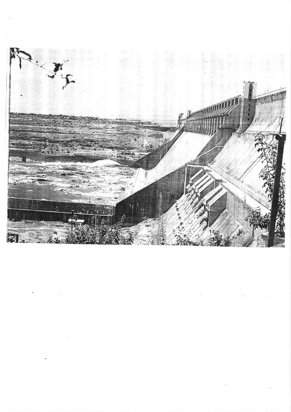
I.3 Description
of
the
Project
The
Nandikonda
Project,
renamed
as
the
Nagar-
junasagar
Project,
under
the inspiring
name
of that
great
Buddhrst Savant,
Acharya
Nagarjuna, who
lived
and
preached
the Mahayana
sect
of
Buddhism
on
the banks
of
the River
Krishna at
this
place,
centuries
&go,
is a
giant
sized
project
with
a massively
labour
and
indigenous
material
oriented
design
and
construc-
maximum height
of
25.9
m
(85
ft),
to create
a
lake
with
a
gross
storage
capacity
of
11.56
T.M.
cu m
(9.37
M.
acre-ft);
with
two canals
taking
off
from
the
reservoir
at
either
flank with
maximum
discharging
78
The_
project
was
taken
up
for
construction
in
December
1955.
Work
on the
construction
of
the dam
km
152
(nile
95)
and the left
main canal
up
to km
178
(mile
I
l
l) with
the
necessary
distribution
system
to create
an
irrigation potential
of
3.20 lakh
ha
(7.89lakh
acres)
on
the right
side
and 1.86 lakh
ha
(4.60
lakh
acres) on
the left side.
The
dam and a
major
portion
of
the
canals
system could
be
completed by
March
1967
due
to the
accelerated
programme
injected into
the construction
schedules
of
the
project
in
the
years
1964-67
to reap
early
irrigation benefits
from
the
project
even
at the con-
struction stage.
The
project
limped
in
progress
there
afterwards
due
to
paucity
of funds
almost
till March
1975, when it
picked
up
again, this time, the
grea-
test
momentum
in
the long and
chequered
history of
the
project
with
the
massive
aid
offered
by the World
Bank.
The
project
is now scheduled
to
be
completed
by
the
year
1981-82.
Great care
was
taken,
right
from
the
commencement
of
theproject,
to create
the
necessary
infrastructure
for the ayacut. such as
excavation
of
field channels
and
drainage
courses,
laying of
ayacut
roads
and market roads, creation
of marketing
centres,
including
loan
assistance
to
the
ryots
from
land
mort-
gage
banks, etc.,
for
land levelling
and
development,
etc.,
to
see
that there
is
practically
no
timeJag
bet-
ween
the
creation
and utilisation of the
irrigation
potential.
Nagarjuna.sagar Project
is
the
fore
runner
in
this
respect.
1.4
Description
of
the
Dam
The
main
dam is
a
straight
gravity
dam
provided
with
an
ogee
profile
for overflow
and
flip
bucket
for
energy dissipation
in
the spillway
portion. It
is
124.7
m
(409
ft)
in height
above the deepest
foundation
level
and
109.7
m
(360
ft)
in height
above
,:l.i'd;"
i!'+
+
+
.'Vp*r
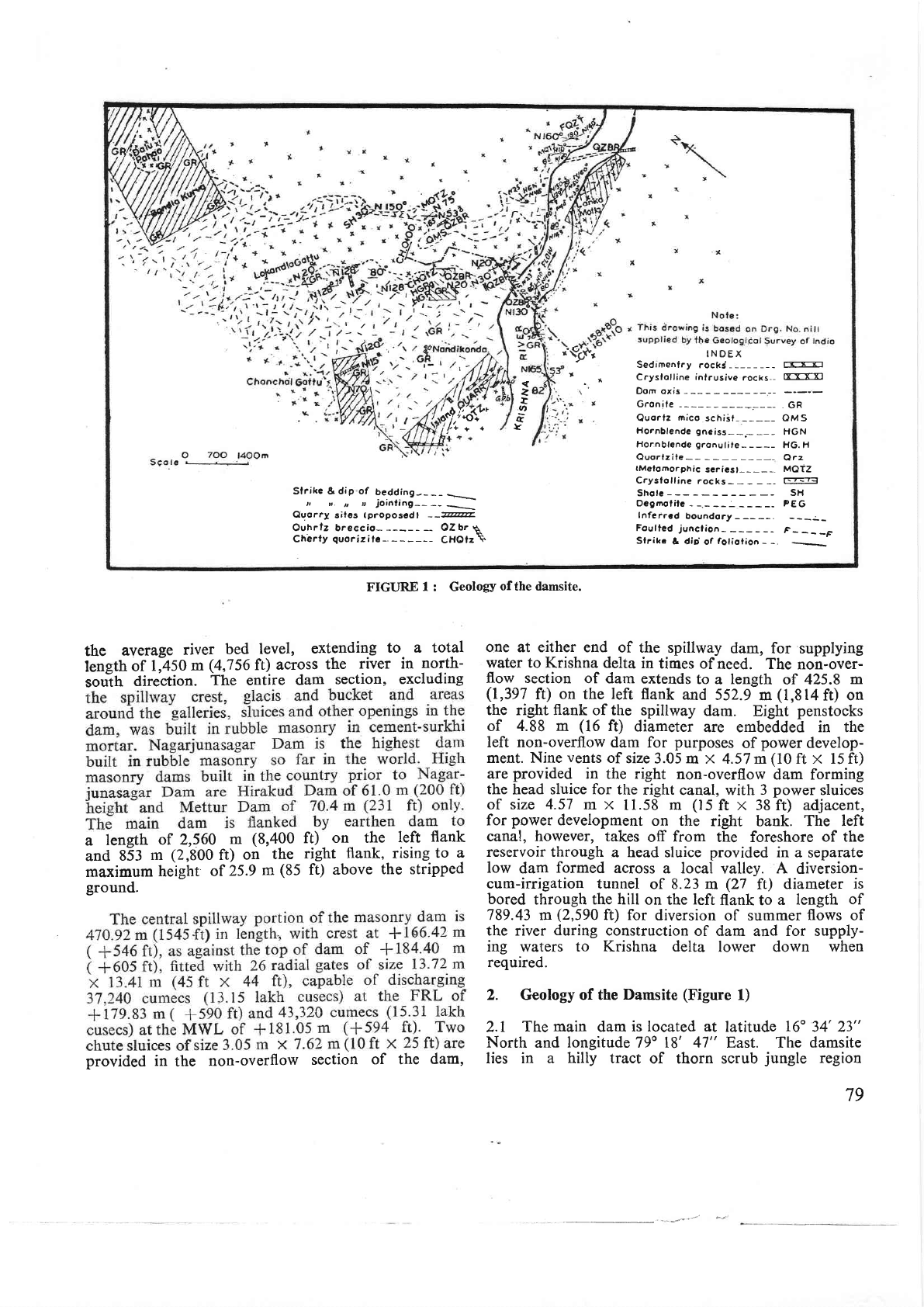
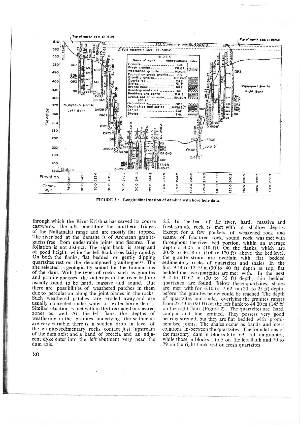
IN.qEX
z
'T
q
rt
t
'
Sedrmenlry
rockC -
Ti-T=r]
*
Crysfotline
inlrusive
rocks--
rrrrr1
Sf
rike
&
dip
of
bedding-___
=_\
t, ,r.
r,
l
joinfing--
Ouorry
siles tproposcdl
--7@
Ouhrlz breccio-
-- OZbr
q
Ch'erty
quorizitc-.
CHOtz\
Dom oxis
Gronile
---_-----,GR
Quortz
mico
schiit-
-----
OM S
Hornblende gneiss-
-.- __ - HGN
Hor.nblende
gronulite-
----
HG. H
Quorfziie-- -----
Qrz
tMelotnorphic
scricst---_-,
MOTZ
CrYsfolline
rocks-
r-?=t
Sholc
-
SH
OcAmof ilc
Inferrcd
boundory
Foulted
junclion-
F-___F
Sfrike
& dirj
of
foliolion
-
-
FIGURE
I
: Geology
of
the damsite.
the
average
river
bed
level,
extending
to- a
total
length
of
1;450
m
(4,756
fc)
across
the
river in
north-
sou-th
direction.
The entire
dam
section,
excluding
a
length
of 2,560
m
(8,400 ft)
on, t!t.
l.ft
flank
and
853
m
(2,800
ft)
on
the
right
flank, rising
to
a
mil(imum
height
of
25.9
m
(85
ft) above
the stripped
ground.
provided
in
the
non-overflow
section
of the
dam,
one at either
end of
the spillway
dam, for
supplying
water to Krishna
delta
in
times of
need. The
non-over-
flow section
of
dam extends
to
a
length
of 425.8
m
(1,397
ft)
on
the
left
flank
and
552.9
m
(l,8t4ft)
on
the
right
flank
of the spillway
dam.
Eight
penstocks
of 4.88 m
(16
f0
diameter
are
embedded
in the
left non-overflow
dam for
purposes
of
power
develop-
ment. Nine
vents
of
size
3.05
m x 4.57 m
(10
ft x 15 ft)
are
provided
in
the right
non-overflow
dam forming
the
head sluice
for
the
right
canal, with
3
power
sluices
of size 4.57
m x
11.58
m
(15
ft
x 38
ft) adjacent,
for
power
development
on the
right bank.
The left
canal,
however,
takes
off
from
the foreshore
of the
reservoir through
a
head sluice
provided
in a
separate
low
dam
formed
across
a local
valley.
A
diversion-
cum-irrigation
tunnel
of
8.23
m
(27
ft)
diameter
is
bored
through
the hill
on
the
left
flank to
a
length
of
789.43 m
(2,590
ft) for
diversion
of summer
flows
of
the river
during
construction
of dam
and
for supply-
ing
waters
to Krishna delta
lower down when
required.
2. Geology of the
Damsite
(Figure
1)
2.1
The main
dam
is located at
latitude
16"
34' 23"
North
and
longitude
79o
18' 47"
East The
damsite
lies
in a hilly tract
of thorn scrub
jungle
region
79
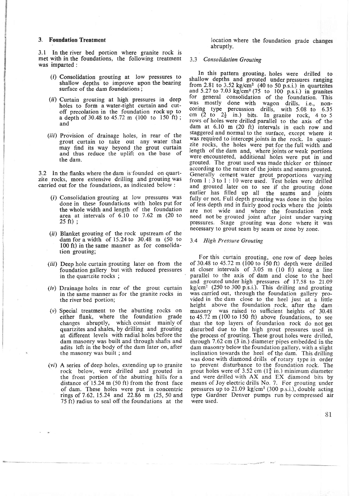
Top
of
.orth don
€t.60t
o
= cr.{r +
Iop
of
eorfh
dom
Et.605.O
lVijoyoprri
-souf
hl
Right
Bonk
490
d60
430
400
370
c
o
E
34o
(u
rlJ
3
lo
280
snL
oRz
oRz
at2
5Aa
Gronodiorlle
____GDR.
EF;E;I
Guorlziles
ond
slofer-___Onl&SlT
Wyyr)
Schisl.-
__- SCH
fr.fi
Shotcs.-
__
_
SHL
-l
o
ro
r-
(D
.')
J
lr,
@
|n
(Vijoyopuri
Norlhl
Lefl
Bonk
O=t38.
sqL
aR2
SHL
GR,
r\,
ttl
v
ru
J
|.,
Elevotron
t\
tYt
tn
co
ct|r|
|frlo
ON
rDo
Q\'
ttlrl
Ii
Ti
nr(tNF
?R8t
(t)
rt, !
N
BRZ
BRZ
99900
ofto
.rro.'SB
99q9
of|o|')
-N(\|
ooooooo
(lo|nO,J,toll)
t\@ao||o}OO
Chorn-
oge
FIGURE
2
:
Longitudinal
section of
damline
with
bore-hole
data.
through
which
the River
Krishna has
carved
its course
eastwards.
The
hills constitute the
northern
fringes
of
the
Nallamalai
range and are
rqostly flat topped.
The
river
bed
at
the
damsite
is of Archaean
granite-
gneiss
free from
undesirable
joints
and fissures. The
foliation
is
not
distinct.
The
right
bank is steep and
of
good
height,
while the left
flank
rises fairly rapidly.
On
both
the flanks,
flat
bedded or
gently
dipping
quartzites
rest
on the
decomposed
granite-gneiss.
The
site
selected
is
geologically
sound
for
the foundations
of
the
dam.
With
the
types of
rocks
such
as
granites
and
granite-gneisses,
the
outcrops in the river bed are
usually
found
to be hard,
massive and sound.
But
there
are possibilities
of weathered
patches
in them
due
to percolation
along
the
joint
planes
in the rocks.
Such
weathered patches
are
eroded
away
and
are
usually
.concealed
under water or water-borne
debris.
Similar
situation
is
met with in
the brecciated
or sheared
zones
as
well. At the
left
flank.
the
depths
of
$'eathering
in
the
granites underlying
the sediments
are
very
variable;
there
is
a
sudden drop in level of
the
granite-sedimentary
rocks contact
just
'upstream
of
the dam
axis;
and
a band
of breccia and an
adja-
cent
dyke
enter
into the left
abutment
very
near
the
dam
axis.
80
2.2
In
the
bed
of
the
river,
hard, massive and
fresh
,qra_nite
rock
is
met
with
at shallow
depths.
Except
for
a few
pockets
of
weakened
rock
and
seams
of
fractured
rock,
sound
rock was
met
with
throughout
the
river
bed portion,
within
an
average
depth
of 3.05
m
(10
ft).
On
the
flanks,
which
are
30.48
to
36.58
m
(100
to I2O
ft) above
the
bed
ievel,
the
granite
strata
are oveflain
with flat
bedded
sedimentary
rocks
of
quartzites
and shales. In
the
first
9.14to 12.19
m(30
to
40
ft)
depth
ar
top,
flat
bedded
massive
quartzites
are
met
with.
In the
next
compact
and fine
grained.
They
possess
very
good
bearing
strength
but
they
are
flat
bedded with
promi-
nent
bed
joints.
The
shales
occur
as
bands
and
inter-
colations
in-between
the
quartzites.
The
foundations
of
the masonry
dam
in
blocks
6
to 69 rest on
granites,
while
those in
blocks
I to
5
on the
left
flank
and
70
to
79
on
the right
flank
rest
on fresh
quartzites.
3.
FoundationTreatment
3.1 In
the
river bed
portion where
granite
rock
is
met
with
in
the foundations,
the
following treatment
was
imparted:
(i)
Consolidation
grouting
at
Iow
pressures
to
shallow depths
to
improve upon
the bearin-e
surface
of the
dam
foundations
;
(fi)
Curtain
grouting
at
high
pressures
in
deep
holes
to
form
a
water-tight
curtain
and
cut-
off
precolation
in the foundation
rock
up
to
a
depth
of
30.48
to
45.72 m
(100
to
150
ft)
;
and
(iii)
Provision o[ drainage
holes, in
rear of the
-srout
curtain
to take
out
any
water
that
may
find
its way
beyond
.the
grout
curtain
and thus
reduce
the
uplift on
the
base of
the
dam.
3.2
In
the flanks
where the
dam
is'founded on
quart-
zite rocks,
more extensive
drillin-e and
grouting
was
carried out
for the foundations,
as indicated
below
:
(r')
Consolidation
grouting
at
low
pressures was
done in these
foundations
with holes
put
for
the
whole
width and
length
of
the foundation
area
at intervals
of 6.10 to
7.62 m
(20
to
25 ft)
;
(ii)
Blanket
grouting of the rock upstream
of
the
dam
for a
width
of
15.24
to
30.48
m
(50
to
I00
ft)
in the
same
manner
as
for
consolida-
tion
groutin-e;
(ifi)
Deep
hole
curtain
grouting
later
on
from
the
foundation
gallery
but
with
reduced
pressures
in
the
quartzite
rocks
;
(iv)
Drainage
holes
in rear
of
the
grout
cgrtain
in
the
same
manner
as for
the
granite
rocks in
the
river
bed
portion;
(v)
Special
treatment
to the
abutting
rocks
on
either
flank,
where the
foundation
-srade
changes
abruptly,
which
consist
mainly of
quartzites
and
shales,
by
drilling
and
grouting
at
different
levels
with
radial holes
before
the
dam
masonry was
built and through
shafts
and
adits
left
in the
body of the darn Iater
on, after
the masonry
was
built
;
and
(vf)
A series
of
deep
holes, extendin-g up to
granite
rock below,
were
drilled and
-srouted
in
the front
portion
of
the abutting hills
for
a
distance
of
15.24 m
(50
ft)
from
the
front
face
of dam.
These holes
were
put
in concentric
rings
of 7.62,
15.24
and
22.86
m
(25,
50
and
75
ft) radius
to
seal
off the foundations
at
the
Iocation
where
the foundation
_9rade
changes
abruptly.
3.3
Consolidation
Grouting
In
this
pattern
_erouting.
holes were
drilled
to
shallow depths
and
grouted
under
pressures
ranging
from
2.81 to 3.52
kg/cms
(40
to
50
p.s.i.)
in
quartiitei
anC
5.27
to
7.03
kglcmz
(75
to 10O p.s.i.)
in
granites
for
general
consolidation
of the
Toundation. This
was
mostly
done
with wagon
drills,
i.e., non-
coring
type
percussion
drills,
with
5.08
to 6.35
cm
(2
to
2+
in.)
bits.
In granite
rock, 4 to 5
ro*s
of
holes
were
drilled
parallel
to
the axis
of
the
dam
at 6.10
m
(20
ft)
intervals
in
each
row and
staggered
and
normal
to the suriace,
except
where
it
was
required
to intercept
joints
in
the
rock. In
quart-
zite
rocks, the
holes
were
put
for
the full
width
and
length
of
the
dam
and,
where
joints
or
weak
portions
were
encountered,
additional
holes
were
put
in and
-srouted.
The
_erout
used
was made
thicker
or
thinner
according
to
the nature
of
the
joints
and
seams
grouted.
Generall,v
cement water
-qrout
proportions
varying
from
1
:3 to I :
l0
were
used.
Test
holes
were
drilled
and
grouted
later
on
to see
if
the
grouting
done
earlier
has
filled
up all
the
seams
and
joints
fully
or not.
Full depth
grouting
was
done
in
the-holes
of less
depth and
in
fairly
good
rocks
where
the
joints
are not
wide
and where
the
foundation rock
need
not
be
-erouted
joint
after
joint
under varying
pressures.
Stage
,erouting
was
done
u,here
it was
necessary
to
_qrout
seam
by seam
or
zone
by zone.
3.4 High Pressure
Grouting
For this curtain
-erouting,
one row
of deep holes
of
30.48 to
45.72
m
(100
to
150
ft) deprh
were
drjlled
at closer
intervals
of
3.05
m
(10
ft)
along
a
line
parallel to the
axis
of
dam
and
close to
the heel
and
grouted
under
high
pressures
of 17.58
to 21,.09
kg/cm:
(250
to 300
p.s.i.).
This
drilling
and
grouting
was
carried
out, through
the foundation
gallery
pro-
vided
in
the dam
close to
the heel
just
at
a
little
height
above
the
foundation
rock,
after
the
dam
masonry
was
raised
to sufficient
heights
of
30.48
to45.72
m
(100
to
I50
ft)
above
foundations,
to
see
that
the
top
layers
of foundation
rock
do not
get
disturbed
due to
the
high
srout
pressures
used
in
the
process
of
grouting.
These
grout
holes
were
drilled,
through
7.62
cm
(3
in.) diameter
pipes
embedded
in the
dam
masonry
below the foundation
_eallery.
with
a slight
inclination
towards
the
heel of the
dam. This
drilling
rvas
done
with diamond
drills
of rotary
type
in order
to
prevent
disturbance to
the
foundation rock.
The
grout
holes
were of 3.52 cm
(1fr
in.) minimum
diameter
and
were
drilled
rvith
AX
and
EX
diamond bits
by
means
of
Joy
electric
drills No.
7.
For
-grouting
under
pressures
up
to
21.09 kg/cm2
(300
p.s.i.),
double
acting
type
Gardner
Denver
pumps
run by
compressed air
were
used.
8l
3.5
Drainage
Holes
3.6 Contact
Grouting
butting
on
to the
vertical
surfaces
of the
abutting
rocks.
3.7
Special
Treatment
in
Weak
Zones
Detailed
exploration
carried
out during
construc-
tion
by
intensive
drilling, washing and
grouting
revealed
the
existence
of fault
and
dyke
zones
in
some
blocks
;
fault
zone in blocks
7
to 9, dolerite
dyke
zone
in
blocks 18 to
23,
crushed zone in
block
55
and
joints
in
blocks
70A
and
71.
Fault
Zone
in
Blocks 7
to
9
:
A
wide
soft area
consisting
of
highly weathered and
crushed
granite
varying
from 1.22to
4.88 m
(4
to
16
ft) in thickness
and dipping
towards
the upstream side
was
located
at
a depthof
6.10
to
30.48
m
(20
to l00ft)
below
a
large
mound
of fresh
granite
rock. [n
the
portion
beyond
the exposed
mound, a trench
was
excavated
deep
enough
to
remove all the
soft
material,
which
was
widened
and
deepened
till fresh
granite
was reached
and
until
the
thickness of
fresh
rock overlying the
fault
zone
was not
less than 7.62
m
(25
ft) at any
place.
The
granite
surface thus
obtained was
roughe-
length
and
removing
the
weathered
and soft
material
and
backfilled
with
concrete.
In addition,
vertical
holes
were
drilled
from the
top
of
the
mound
and
82
V:WDolerite
Dyke
in
Blocks
18
to 23
:
A
dolerite
dyke
intercepted
the foundations
extending
from
the
up-
stream
end of
block
18
to the
do*nstream
end
of
with
9.14
m
(30
ft)
deep holes.
The
full
lengrh
of
the
dyke
traversing
the fbundation
area was excavated
to
a depth
of not
less
than
twice the width of
the
dyke zone,
all
the
soft
material
including
fractured
rock
removed
and
hard
granite
surface
exposed.
Drilling
and
grouting
was
done
in
the
trench and
in
the rocks
on
either side.
It
was
found that
the
actual
dyke zone was
tight due
to
the
presence
of
clay
along its
entire
length. But
the
roc[s
on either side
of
the
dyke
took
an
appreciable
quantum
of
grout.
About
1,522
bags
of cement
were
grouted
into these
rocks.
The
trench
and
the
shaft were
.then
back-
filled
with
concrete
up
to
the
general
foundation level
in
the
area with
grout
condulets
provided
at
the
contact
planes
of
concrete
and
rock
for
contact
grouting
to be
done
later
on
after shrinkage and settle-
ment
take
place.
On the
top
of
the shaft,
a concrete
raft
yas
provided
with
29.76
!g1m
(20
_lb/rft)
rails
spanning
over
the shaft
at 0.61
m
(2
ft)
intervals
both
ways.
Crushed
Zone
in Block
55
: A 0.61 to
1.22 m
(2
to
4 ft)
wide band
of
crushed
zone
was
met
with
in
block
55 traversing
the
full
width
of
excavation at
right
angles
to
the axis
of the dam
with
a dip of
45"
towards
the
right
abutment.
On
drilling exploratory
holes,
it
was
revealed
that
the
crushed zone extended
to a
considerable
depth
at
the
same dip angle and
in
the same
direction. This
crushed zone
was
also
treated
almost
in
fhe
same manner
as
the
dolerite
dyke in
-
blocks
18
to 23,
by
excavating
a shaft
of
11.28
m
X
5.18
m
(37
ft x 17
ft)
size
to a
depth
of
9.l4
m
(30
ft)
at the
upstream
end
of
this fault to serve
as
a
cutoff.
The
shaft
was
drilled
and
grouted
from
the
bottom
and
sides
at different levels
with
radial
holes
of
9.14
m
(30
ft) depth. Along
the length of the crushed
zone,
a trench
was excavated
to sufficient
width and
depth of not less than
twice the
width.
The
adjacent
areas
along
the
length
of
the trench
in
blocks 56
and 57
the
shaft
were
backfilled
with
concrete
and taken out
into
the
foundation
gallery
for observation
purposes
at
a
later
date.
R.C.C.
raft was
provided
with29.76
kg/m
(20
lb/rft) rails
placed
at
0.61
m
(2
ft) intervals
both
ways
to
span over the crushed
zone,
with
grout
condulets
placed
on
the
contact
surfaces
for
contact
grouting
later on.
Joints
in Blocks 70A
and
7I
: The
dam is founded
on
quartzite
rock
in
blocks
70A
and 7 | u'here
open
joints
were found,
5.08
to 7.62 cm
(2to
3
in.)
wide
at
the
surface,
narrowing
down
to
2.54
cm
(1
in.)
at
lower
levels.
This
joint
transversed
the
full
width
of
the dam
in
block 7
|
and
extended
to
considerable
depth
up
to
the
shaley strata below.
A
3.05
to
4.57
m
(10
to
15ft)
wideopen
trench was
excavated
along
this
joint
and
a
number of
drill holes
were
put
on
eithei
side of
the
joint,
spacing as
well
as inclina-
tion
of
the
holes
being so fixed
as to intercept
the
joint
at
different
depths.
The
joint
was then
thoroughly
cleaned through all
these
holes,
grouting
done
to refusal
and the
trench
backfilled
with
concrete,
leaving
grout
condulets on the
rock surface
for
contact
grouting
later
on. An
R.C.C.
raft was
laid over
the
trench
for
the
full
length.
In addition,
3
rows of
deep
holes extending to
the
granite
rock
below
were drilled
upstream
of the dam,
parallel
to
the
axis,
for
the
full
width
of
the block
and
grouted.
The
joint
in
block
70A
did
not extend
to
the full
width
and,
as such, the
length
of
trench
excavated
was smaller.
Sloptng
Foundations
in
Block
6
:
There
\\'as
a steep
fall
of
about
22.5 m
(74
ft.)
in a
length
of about
4.
Design
of
Dam
(Figures
3
&
4)
4.1
River
Diversion
The
lftishna
basin
is influenced
mostly by
South-
West
monsoon during the
period from June to October
when
the runoff is
maximum.
A
study of
the
hydrographs
of
the
river at
the
Vijayawada anicut
3.8 Treatrnent
for
Earth
Dam
Foundafions
The
foundations
of right
earth dam
consist mainly
of
massive quartzite
boulders
with gravel pockets.
A
cutofftrench
of
6.10 m (20
ft)
width
anO
2.44
to
3.05
m
(8
to
l0 ft)
depth was
excavated
and two
lines
Part
ff-
I)esign
over
a
period
of 60
years
from
the
year
1894
to 1956
shorved that
the
river
is
generally
high
during the
period
fronr
June
to
October
and that
a
flood
of
over
14,000 cumecs
(5
lakh
cusecs)
occurred
28
times,
over
23,000 cumecs
(8
lakh cusecs) five
times
and
over
28,000
cumecs
(10
lakh
cusecs) once.
Further,
by
the end of
December,
the
discharge
in the
river
83
--4d'4
E
H
'4
a
io
:t
o
t\f
r(3
o
Eg
es
r:i
9g
!t
t
5
of,rcthdsn
ELl84.aO
o
u/s-Et€vATtox
9_3ejo'
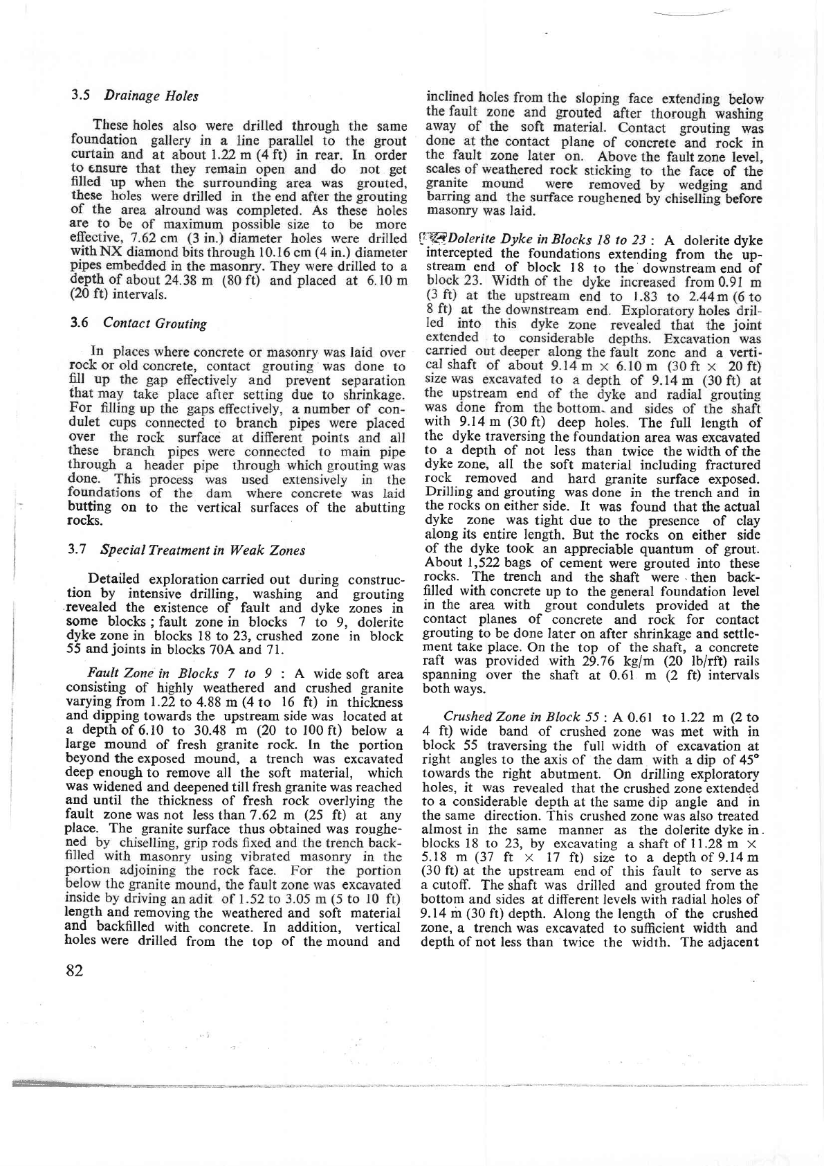
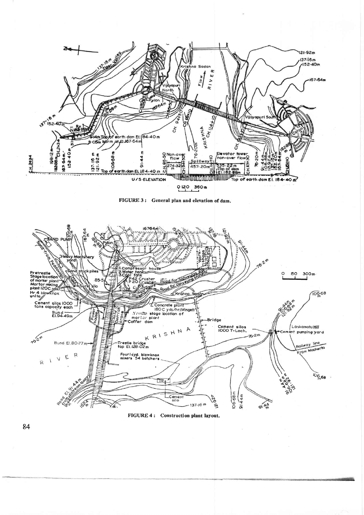
FIGURE
3
: General
plan
and
elevation
of dam.
Bridge
.
Cement
silos
IOOO
7-Loch.
oTcorth
don
Et.l8+'{O
Prelresf
le
Sfogelocotiori
of
morior
Morlor
mhi
glont
l?OC
Hr.4
unl
O
FO 3OOm
Cernent
sitos
IOOO
tons
copocity
coch
Bund
-
81.94.49m
/n$
,1(2'"
"{""
<o'-
T":
@*ot
Y
cf
\q
6
.f
i'i+l#s
sloge locolion
of
moriJi'plqrt
Coffer dom
KR\5HN
A
Treslle
bri&e
top
Er. t?€.dzm
Fourlcyd.
blowknox
mixers
54
bolcherg
84
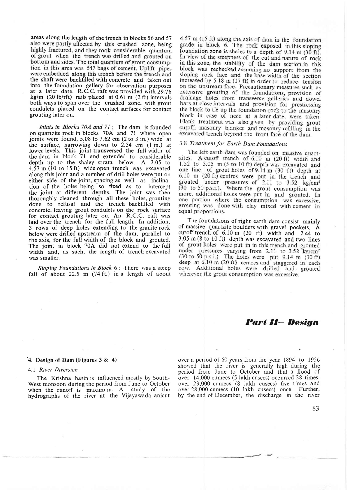
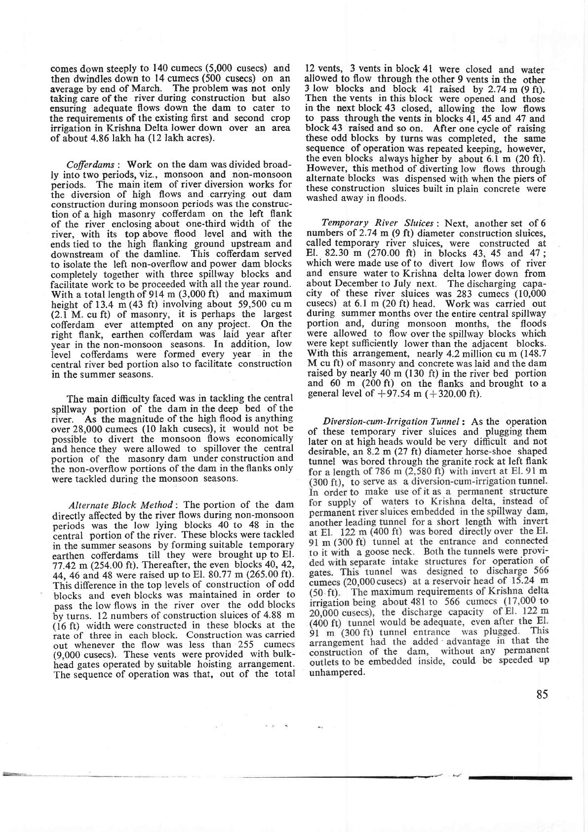
FIGURE 4
: Construction
plant
layout.
comes
down steeply
to
140 cumecs
(5,000
cusecs) and
then
dwindles
down
to
14
cumecs
(500
cusecs)
on
an
average
by end
of
March.
The
problem
was not only
taking
care of
the
river during construction but also
ensuring
adequate
flows down the dam
to cater
to
the
requirements
of
the existing
first and
second crop
irrigation
in Krishna
Delta lower down
over an
area.
of
about
4.86 lakh
ha
(12lakh
acres).
Cofferdams
:
Work
on
the dam was
divided
broad-
ly into
two
periods,
viz.,
monsoon
and non-monsoon
periods.
The
main
item of
river
diversion works for
the diversion
of high flows
and
carrying
out
dam
construction
during monsoon
periods
was
the
construc-
tion
of a
high
masonry
cofferdam
on
the
left
flank
of
the
river enclosing
about
one-third
width
of the
river,
with its
top
above
flood
level
and with
the
ends
tied
to the
high
flanking
ground
upstream
and
downstream
of the
damline.
This
cofferdam
served
to isolate the left
non-overflow
and
power
dam blocks
completely
together
with three
spillway
blocks
and
facilitate
rvork
to be
proceeded
with
all the
year
round.
With
a
total
length of
914
m
(3,000
ft)
and
maximum
height of
13.4 m
(43
ft)
involving about
59,500
cu
m
(2.i
M.
cu ft)
of masonry,
it
is
perhaps
the
largest
cofferdam ever
attempted
on any
project.
On
the
right
flank,
earthen
cofferdam
was
laid
year after
year
in
the
non-monsoon
seasons.
In
addition,
low
level
cofferdams
were
formed
every
year
in
the
central river
bed
portion also to
facilitate construction
in
the summer
seasons.
The
main difficulty
faced
was
in tackling
the central
spillway
portion
of the
dam in
the deep bed
of
the
river. As the
magnitude
of the
high
flood
is anything
over
28,000
cumecs
(10
lakh cusecs),
it
would not
be
possible
to
divert
the
monsoon
flows
economically
and
hence
they
were allowed
to spillover
the central
portion
of
the
masonry
dam
under
construction
and
ihe
non-overflow
portions
of the
dam
in the flanks
only
were
tackled during
the
monsoon
seasons.
Alternate Block Method:
The
portion
of the
dam
directly
affected
by
the
river
flows
during non-monsoon
periods
was
the
low
lying
blocks 4A
to
48 in
the
ientral
portion
of the river.
These blocks were
tackled
in the
summer
seasons
by forming
suitable temporary
earthen
cofferdams
till
they
were brought up to
El.
77.42
m
(254.00
ft).
Thereafter, the even
blocks 40?
42,
44,
46 and 48
were
raised
up
to
El.
80.77
m
(265.00
ft):
This
difference
in
the
top levels
of
construction
of
odd
blocks
artd
even
bLocks
was maintained
in
order to
pass the
low
flows
in
the
river
over the
odd blocks
6y
turns.
l2 numbers
of construction
sluices of 4.88
m
(ie
ft)
width
were constructed
in
these
blocks
at the
rate
of
three in each block.
Construction
was carried
out
whenever the flow
was
less than
255 cumecs
(9,000
cusecs).
These vents
were
provided
with bulk-
head
gates operated by
suitable
hoisting
arrangement.
The
sequence
of operation
was that,
out
of
the
total
12 vents,
3
vents
in
block 41
were
closed
and
water
allowed
to
flow
through
the
other
9
vents in
the
other
3
low
blocks
and block
4t
raised
by 2.74 m
(9
ft).
Then
the
vents
in
this
block were
opened
and those
in the next
block
43
closed,
allowing
the
low
flows
to
pass
through the vents
in blocks
41,45 and
47
and
block
43 raised
and
so
on.
After
one
cycle
of
raising
these
odd
blocks by
turns was
completed, the same
sequence
of operation
was repeated
keeping,
however,
the
even blocks
ahvays
higher
by
about
6. I
m
(20
f0.
However, this method
of
diverting low flows
through
alternate blocks was
dispensed with
when the
piers
of
these
construction
sluices
built in
plain
concrete
were
washed away
in
floods.
Temporary
River
Sluices
:
Next,
another
set of 6
numbers of
2.74
m
(9ft)
diameter
construction sluices,
called temporary river
sluices, were
constructed
at
El.
82.30 m
(270.00
f0
in
blocks 43,
45
and
47
;
which were
made
use of
to divert
low flows
of river
and
ensure
water
to
Krishna
delta lower down from
about
December
to
July
next.
The
discharging
capa-
city
of
these river
sluices
was 283 cumecs
(10,000
cusecs)
at 6.7
m
(20
ft) head.
Work
was
canied out
during
summer
months
over
the
entire central
spillway
portion
and, during
monsoon
months, the floods
were
allowed
to
flow
over
the
spillway
blocks
which
were
kept
sufficiently
lower
than
the adjacent
blocks.
With
this
arrangement,
nearly
4.2
million
cu m
(148.7
M cu
ft)
of
masonry
and
concrete
was laid
and
the
dam
raised by
nearly
40 m
(130
ft) in the river
bed
portion
and 60
m (200
ft)
on the flanks
and brought
to a
general
level
of
*97.54
m
(*
320.00 ft).
Diversion-cum-Irrigation
Tunnel
: As
the
operation
of these
temporary
river sluices
and
plugging
them
later
on at
high heads
would
be
very
difficult
and
not
desirable,
an
8.2
m
(27
ft)
diameter
horse-shoe
shaped
tunnel
was bored through the
granite
rock
at
left
flank
unhampered.
85