Houze Robert A., Jr. Cloud Dynamics
Подождите немного. Документ загружается.

7.4 Vorticity 249
clouds become tilted out of the horizontal, some of the rotation is about a vertical
axis. This vertical component of vorticity can become quite concentrated and is
manifested most strongly in funnel clouds, waterspouts, and tornadoes.
While it is, of course, possible to view the fluid motions in convective clouds in
terms of pressure gradients and buoyancy in the context of the equation of motion
(7.2), the presence of vortical motions in clouds makes it enticing to examine the
air motions via the vorticity equations (2.58) and (2.59), which eliminate the
pressure-gradient terms and address the rotation directly in terms of the buoyancy
source. In this section, we will examine briefly the development of vorticity in
convective clouds in terms of the horizontal and vertical vorticity equations. Here
we will introduce some basic concepts, which will be applied further and elabo-
rated on in later chapters concerned with thunderstorms and mesoscale convec-
tive systems.
7.4.2 Horizontal Vorticity
The generation of horizontal vorticity
~
in a two-dimensional Boussinesq fluid is
governed by (2.61), which says that the only way that vorticity about a horizontal
axis can develop within a two-dimensional parcel
of
air is through a horizontal
gradient
of
buoyancy Ex (i.e., by baroclinic generation). In the case of convective
clouds, the primary situations in which
~
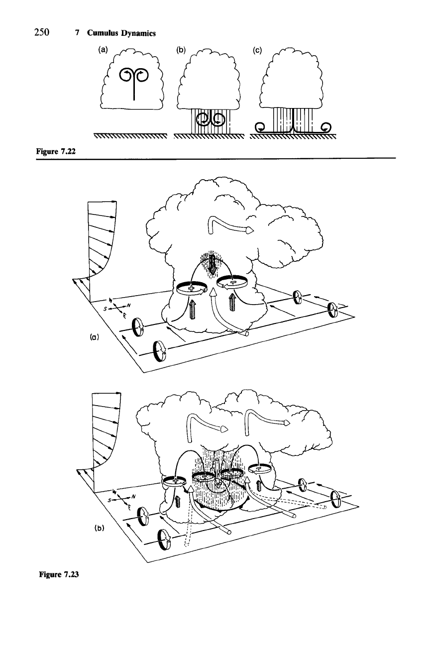
is generated baroclinically are illustrated
in Fig. 7.22. The case
ofthe
positively buoyant rising element that overturns like a
Hill's vortex (Sec. 7.3.2) is represented in Fig. 7.22a. In this case, a maximum of
positive buoyancy is centered in the element, so that
Ex is of equal magnitude and
Figure 7.18 Paluch diagram showing aircraft measurements (small crosses) and environmental
sounding data (heavy solid line) for a real cumulus cloud in which air from cloud base (heavy cross)
mixes in various fractions with air entrained from near flight level (about
570 mb). (From Austin et al.,
1985. Reprinted with permission from the American Meteorological Society.)
Figure 7.19 Paluch diagram of the total water mixing ratio
qr(
= q, + qc) and "equivalent potential
temperature"
(6,) for an idealized aircraft flight in a cumulus cloud in which the parcels of air
encountered at flight level are mixtures of cloud-base air and environmental air entrained at a
multiplicity of altitudes and balloon ascent in the environment. Cloud top is determined by the rise of
the few
"lucky"
undiluted parcels.
Figure 7.20 Paluch diagram showing aircraft measurements (small crosses) and environmental
sounding data (heavy solid line) for a real cumulus cloud in which the parcels of air encountered at
flight level are mixtures of air from cloud base (heavy cross) and environmental air entrained at a
multiplicity of altitudes. (From Taylor,
1987.)
Figure 7.21 Cumulus cloud conceptualized as consisting of a collection of parcels that each
undergo mixing with entrained air at one and only one level. Equal parcels are considered to be
released from cloud base to each of several discrete levels above cloud base
(i,j,
etc.). Upon reaching a
designated level, each parcel is split into several subparcels, each mixing with a different fraction of
environmental air. Cloud top is determined by the rise of the few
"lucky"
undiluted parcels. (Based on
Raymond and Blyth,
1986.)
250 7 Cumulus Dynamics
Figure 7.22
(b)
Figure 7.23
7.4 Vorticity
251
opposite sign on either side of the center line of the element. Counter-rotating
vortices are thus produced on either side of the cloud. These vortices are entirely
consistent with the buoyancy pressure gradient force field associated with the
motions (Fig. 7.1). The case of a negatively buoyant downdraft associated with
evaporative cooling and precipitation drag in the rain shower of a convective
cloud is illustrated in Fig. 7.22b.
It
is the upside-down version of the overturning
updraft. A maximum of negative buoyancy is centered in the element, so that
B, is
again of equal magnitude and opposite sign on either side of the element, and
counter-rotating vortices are again produced. As a downdraft of dense air spreads
out along the ground, a strong buoyancy gradient and vortex is maintained at the
leading edge of the outflow (Fig. 7.22c).
7.4.3 Vertical Vorticity
On the basis of numerical modeling and observations by Doppler radar of severe
thunderstorms, it is now generally agreed that intense vorticity about a vertical
axis
(0 in convective clouds has its origin as horizontal vorticity. One way that
the vertical vorticity in cloud arises is by converting horizontal vorticity of the
environment to vertical vorticity in cloud. This process of conversion is easily
envisaged by considering a large-scale environment in which the mean flow
ii is
unidirectional in the x-direction and increasing with height. Then the environment
has horizontal vorticity whose value is the shear
aii/az. This vorticity is illustrated
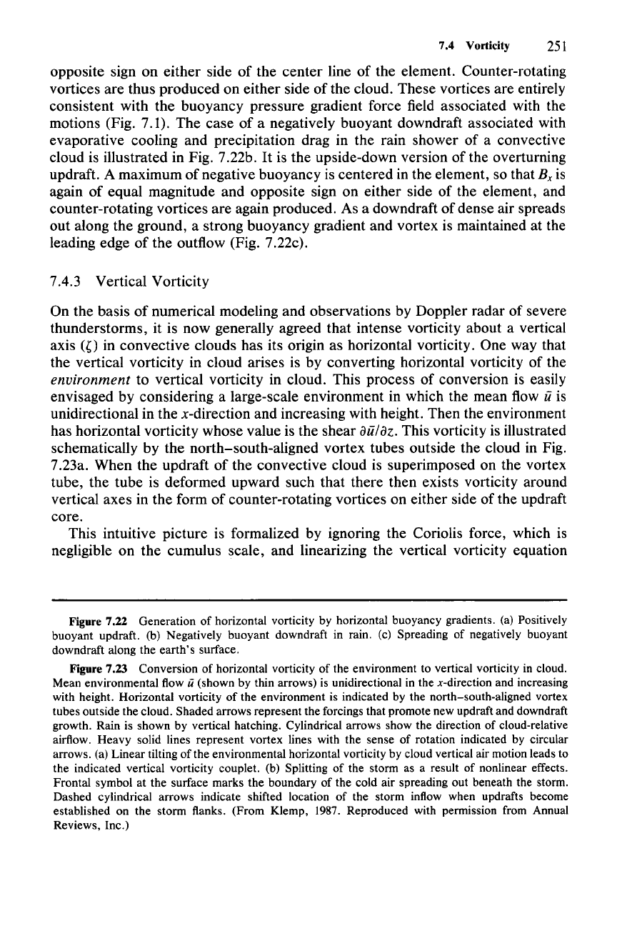
schematically by the north-south-aligned vortex tubes outside the cloud in Fig.
7.23a. When the updraft of the convective cloud is superimposed on the vortex
tube, the tube is deformed upward such that there then exists vorticity around
vertical axes in the form of counter-rotating vortices on either side of the updraft
core.
This intuitive picture is formalized by ignoring the Coriolis force, which is
negligible on the cumulus scale, and linearizing the vertical vorticity equation
Figure 7.22 Generation of horizontal vorticity by horizontal buoyancy gradients. (a) Positively
buoyant updraft. (b) Negatively buoyant downdraft in rain. (c) Spreading of negatively buoyant
downdraft along the earth's surface.
Figure 7.23 Conversion of horizontal vorticity of the environment to vertical vorticity in cloud.
Mean environmental flow
ii (shown by thin arrows) is unidirectional in the x-direction and increasing
with height. Horizontal vorticity of the environment is indicated by the north-south-aligned vortex
tubes outside the cloud. Shaded arrows represent the forcings that promote new updraft and downdraft
growth. Rain is shown by vertical hatching. Cylindrical arrows show the direction of cloud-relative
airflow. Heavy solid lines represent vortex lines with the sense of rotation indicated by circular
arrows. (a) Linear tilting of the environmental horizontal vorticity by cloud vertical air motion leads to
the indicated vertical vorticity couplet. (b) Splitting of the storm as a result of nonlinear effects.
Frontal symbol at the surface marks the boundary of the cold air spreading out beneath the storm.
Dashed cylindrical arrows indicate shifted location of the storm inflow when updrafts become
established on the storm flanks. (From Klemp, 1987. Reproduced with permission from Annual
Reviews, Inc.)
252 7 Cumulus Dynamics
(2.59) about the mean flow v = (u,0,0).187 In this case we obtain the perturbation
form of the equation
(7.68)
If
we consider a level where uapproximates the velocity of the cloud relative to
the ground, (7.68) becomes
(7.69)
in a system moving with the cloud. Thus, tilting of the vortex tubes of the mean-
flow shear is the only important source of perturbation vorticity
".
In the case
shown in Fig. 7.23a, this process leads to positive " on the south side of the
updraft and negative
r on the north side of the updraft.
Numerical models and Doppler radar data confirm that linear tilting of the
environmental horizontal vorticity is an important mechanism for the formation of
vertical vorticity in convective clouds that form in environments of substantial
shear (large
u
z).188
The r couplet shown in Fig. 7.23a is indeed a characteristic of
the early stage of convection that develops in shear. The counter-rotating "
couplet, among other things, constitutes a mechanism of entrainment. In the case
shown in Fig. 7.23a, the vortices would draw environmental air into the east side
of the storm at midlevels. Our previous discussion of entrainment (Sec. 7.3)
considered only those entrainment processes that would occur in an environment
without shear.
It
is evident from the present discussion that entrainment in con-
vective clouds in strongly sheared environments will be enhanced as a result of
the vortex couplet straddling the updraft.
As clouds develop beyond the stage illustrated in Fig. 7.23a, nonlinear effects
become important. These effects have also been inferred from numerical-model-
ing results.
189
It
has been found that the perturbation vorticity equation becomes
(7.70)
The difference from (7.68) is that now stretching
(rw
z
)
is important in addition to
tilting. The regions oflarge
IWzl
at the tops and bottoms of the convective updrafts
and downdrafts are especially conducive to strong vortex stretching.
Processes that occur during the later phases of cumulonimbus development will
be discussed in Chapter 8.
For
reasons to be discussed there, we will see that a
severe thunderstorm in an environment of strong unidirectional shear, like that
depicted in Fig. 7.23a, splits in half, with the two halves moving in opposite
directions along the y-axis, as indicated in Fig. 7.23b. The cloud motion relative to
the ground at this stage of storm development may then be represented by
(7.71)
\87 The mathematical arguments and deductions from numerical-model results presented in this
subsection are from Rotunno (1981) and the review article of Klemp (1987).
\88 See the review of Klemp (1987).
189 Ibid.
7.5 Modeling of Convective Clouds
253
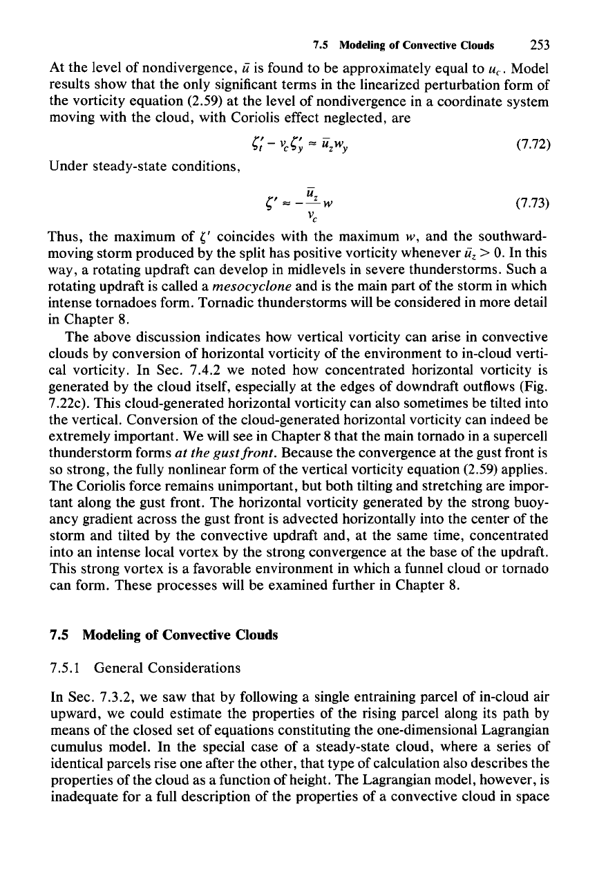
At the level of nondivergence, uis found to be approximately equal to
u.,
Model
results show that the only significant terms in the linearized perturbation form of
the vorticity equation (2.59) at the level of nondivergence in a coordinate system
moving with the cloud, with Coriolis effect neglected, are
(7.72)
(7.73)
Under steady-state conditions,
Sf
""
-~w
V
c
Thus, the maximum of " coincides with the maximum w, and the southward-
moving storm produced by the split has positive vorticity whenever
ii,
>
O.
In this
way, a rotating updraft can develop in midlevels in severe thunderstorms. Such a
rotating updraft is called a
mesocyclone and is the main part of the storm in which
intense tornadoes form. Tornadic thunderstorms will be considered in more detail
in Chapter 8.
The above discussion indicates how vertical vorticity can arise in convective
clouds by conversion of horizontal vorticity of the environment to in-cloud verti-
cal vorticity. In Sec. 7.4.2 we noted how concentrated horizontal vorticity is
generated by the cloud itself, especially at the edges of downdraft outflows (Fig.
7.22c). This cloud-generated horizontal vorticity can also sometimes be tilted into
the vertical. Conversion of the cloud-generated horizontal vorticity can indeed be
extremely important. We will see in Chapter 8 that the main tornado in a supercell
thunderstorm forms
at the
gust
front, Because the convergence at the gust front is
so strong, the fully nonlinear form of the vertical vorticity equation (2.59) applies.
The Coriolis force remains unimportant, but both tilting and stretching are impor-
tant along the gust front. The horizontal vorticity generated by the strong buoy-
ancy gradient across the gust front is advected horizontally into the center of the
storm and tilted by the convective updraft and, at the same time, concentrated
into an intense local vortex by the strong convergence at the base of the updraft.
This strong vortex is a favorable environment in which a funnel cloud or tornado
can form. These processes will be examined further in Chapter 8.
7.5 Modeling of Convective Clouds
7.5.1 General Considerations
In Sec. 7.3.2, we saw that by following a single entraining parcel of in-cloud air
upward, we could estimate the properties of the rising parcel along its path by
means of the closed set of equations constituting the one-dimensional Lagrangian
cumulus model. In the special case of a steady-state cloud, where a series of
identical parcels rise one after the other, that type of calculation also describes the
properties of the cloud as a function of height. The Lagrangian model, however, is
inadequate for a full description of the properties of a convective cloud in space
254 7 Cumulus Dynamics
and time. The need for a more complete description is acute. Radar, aircraft,
satellite, and other special observational platforms can be employed to observe
the detailed structure and evolution
of
certain fields in developing clouds (such as
the wind and radar reflectivity). These observational technologies can be ex-
tended by methods such as the retrieval technique described in Sec. 4.4.7 to
diagnose variables beyond those which can be observed directly. However, it is
impossible with any foreseeable technology to observe or diagnose all of the
thermodynamic, kinematic, and water fields simultaneously in a developing cumu-
lus or cumulonimbus cloud with the spatial and the temporal resolution required
to understand the cloud physics and dynamics. As a substitute for a complete set
of observations, the science of convective cloud modeling is employed to calcu-
late the relevant fields simultaneously in a physically consistent way from first
principles. By seeking agreement of the model results with the few fields that are
observed, one can then use the model output to extend the understanding of the
clouds. In the following subsections, we summarize how the basic equations are
organized to formulate the basic types of convective cloud models that are in use.
The goal is to familiarize the reader with the physical basis of the models. We
make no attempt to review problems related to numerical solutions, as this topic
would fill a book by itself.
7.5.2 One-Dimensional Time-Dependent Model
The first type of model we will examine is the one-dimensional time-dependent
model.
190
It
is simplified in that it predicts only the horizontally averaged proper-
ties in cloud. However, these properties are computed as functions of time, thus
providing an indication
of
the cloud's evolution. The computed variables are
considered to be deviations from environmental values. If
slc represents the in-
cloud value of any quantity
sl,
then
slc =sle+
sl
* (7.74)
The model is formulated in cylindrical coordinates
(r,8,Z),
and the cloud region is
specified a priori to have a radius
R(z).
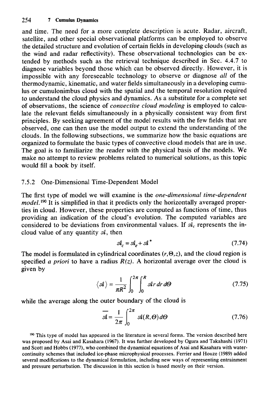
A horizontal average over the cloud is
given by
\sl)
=
~
f2/r
fR
cAr
dr
de
nR
Jo
Jo
while the average along the outer boundary of the cloud is
~
1
12/r
cA= -
cA(R,e)de
2n
0
(7.75)
(7.76)
190 This type of model has appeared in the literature in several forms. The version described here
was proposed by Asai and Kasahara (1967).
It
was further developed by Ogura and Takahashi (1971)
and Scott and Hobbs (1977), who combined the dynamical equations of Asai and Kasahara with water-
continuity schemes that included ice-phase microphysical processes. Ferrier and Houze (1989) added
several modifications to the dynamical formulation, including new ways of representing entrainment
and pressure perturbation. The discussion in this section is based mostly on their version.
7.5 Modeling of Convective Clouds 255
The deviation from the
area
average of
.stl
* will, for simplicity, be written as
.stl':
.stl*
-
(.stl*
) (7.77)
Strictly, it should be written as
(.stl*)'.
The deviation from the boundary average is
.stl":
.stl*(R,
8)
-.stl * (7.78)
(7.79)
(7.80)
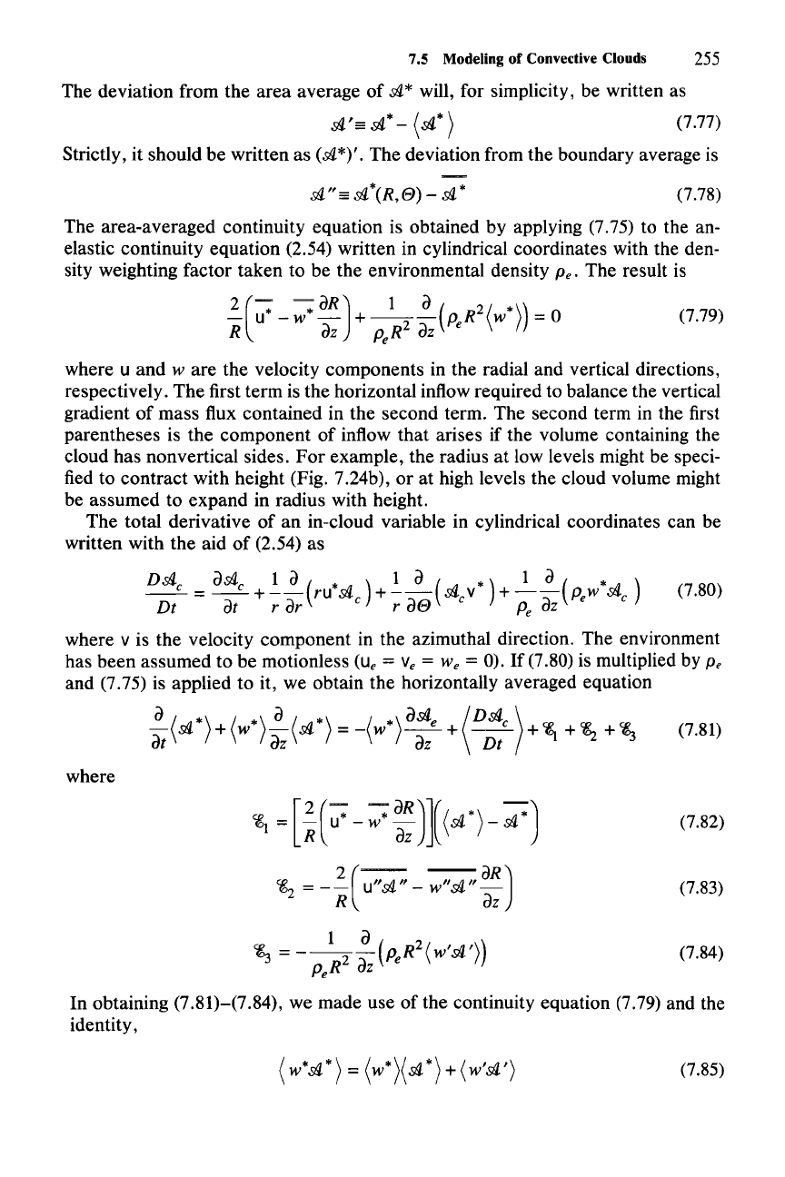
The area-averaged continuity equation is obtained by applying (7.75) to the an-
elastic continuity equation (2.54) written in cylindrical coordinates with the den-
sity weighting factor taken to be the environmental density
Pe. The result is
2
(-=
~
dR) 1 d ( 2 (
*))
- u - w - +
---
PeR
w = 0
R
dZ
PeR2
dZ
where u
and
ware
the velocity components in the radial and vertical directions,
respectively.
The
first term is the horizontal inflow required to balance the vertical
gradient of mass flux contained in the second term. The second term in the first
parentheses is the component of inflow
that
arises if the volume containing the
cloud has nonvertical sides.
For
example, the radius at low levels might be speci-
fied to contract with height (Fig. 7.24b), or at high levels the cloud volume might
be assumed to
expand
in radius with height.
The
total derivative of an in-cloud variable in cylindrical coordinates can be
written with
the
aid
of
(2.54) as
D.stl
d.stl
1
dId
* 1 d ( * )
__
c =
__
c +
--(ru*.stl
c
) +
--;-(.stl
c
v ) + --=:;-
Pew
.stl
c
Dt at r dr r
08
P
e
oz
where v is the velocity component in the azimuthal direction. The environment
has
been
assumed to be motionless
(u,
= v, =
We
= 0). If (7.80) is multiplied by
Pe
and (7.75) is applied to it, we obtain the horizontally averaged equation
where
[
2(
-:
-*
dR)](( *)
-*)
<&1
= R u - W
a;-
.stl
-
.stl
2(-
-aR)
<&2
= - R u"
.stl"
-
w".stl"
a;-
(7.82)
(7.83)
(7.84)
1 d
~
=
---(p.
R
2(
w'.stl'))
Pe
R2
dZ
e
In obtaining (7.81)-(7.84), we made use of the continuity equation (7.79) and the
identity,
(W*.stl*)
=
(W*)(.stl*)
+ (w'.stl')
(7.85)
256
7
Cumulus Dynamics
(a)
(w>
(b)
(w)
,.4km-
D
u·
z=4km-
D
=.
u
I
=.
I
u·
u
tt
tt
,
z
I
{)
_cloud
I
{)
--0---
base
--0--
z
=0
km-
,
Fi~re
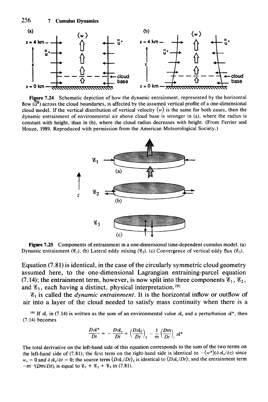
7.24 Schematic depiction of how the dynamic entrainment, represented by the horizontal
flow
(ifI') across the cloud boundaries, is affected by the assumed vertical profile of a one-dimensional
cloud model.
Ifthe
vertical distribution of vertical velocity (w) is the same for both cases, then the
dynamic entrainment of environmental air above cloud base is stronger in (a), where the radius is
constant with height, than in (b), where the cloud radius decreases with height. (From Ferrier and
Houze, 1989. Reproduced with permission from the American Meteorological Society.)
";gl
z
Figure 7.25 Components of entrainment in a one-dimensional time-dependent cumulus model. (a)
Dynamic entrainment
(~I)'
(b) Lateral eddy mixing
(~2)'
(c) Convergence of vertical eddy flux
(~3)'
Equation (7.81) is identical, in the case
ofthe
circularly symmetric cloud geometry
assumed here, to the one-dimensional Lagrangian entraining-parcel equation
(7.14); the entrainment term, however, is now split into three components
~l,
~2,
and
~3,
each having a distinct, physical interpretation. 191
~I
is called the dynamic entrainment.
It
is the horizontal inflow or outflow of
air into a layer of the cloud needed to satisfy mass continuity when there is a
191 If
.sI1.
e
in (7.14) is written as the sum of an environmental value
.sI1.
e
and a perturbation
.sI1.*,
then
(7.14) becomes
D.sI1.*
= _
D.sI1.
e
+
(D.sI1.
c)
_
-.!-
(Dm)
.sI1.*
Dt Dt Dt s m Dt i
The total derivative on the left-hand side of this equation corresponds to the sum of the two terms on
the left-hand side of (7.81); the first term on the right-hand side is identical to
-(w*)(a.sl1.,Iaz) since
We = 0 and
a.sl1.
efat
= 0; the source term
(D.sI1.c1Dt)s
is identical to
(D.sI1.,JDt);
and the entrainment term
-m-I(DmlDtli
is equal to
~1
+
~2
+
~3
in (7.81).
7.5 Modeling of Convective Clouds
257
vertical gradient of vertical mass flux across the layer (Fig. 7.25a). It is assumed
that
.cA*
is zero when there is inflow and is equal to the in-cloud average
(.cA*)
when
there is outflow.
Thus,
'i8
1
dilutes the cloud when entrainment is occurring, but is
zero when detrainment occurs. Dynamic entrainment is a strong effect in this type
of model and is not independent of the assumed model geometry. Figure 7.24
shows how the same vertical distribution of vertical velocity
(w*) has less inflow
and hence less dilution of in-cloud properties when the model domain is wider at
low levels.
It
is indeed a weakness of this type of model that the shape of the
domain can determine whether or not the cloud will form and what its internal
properties will be. One must be careful to specify a realistic shape for the domain
if this type of model is to be useful.
'i8
2
is the lateral eddy mixing, which is the turbulent mixing of air across the
boundary without a net exchange of mass across the cell boundaries (Fig. 7.25b).
There is observational evidence that the lateral mixing is smaller than vertical
mixing.
192 In addition, dimensional arguments have often been invoked to indicate
that
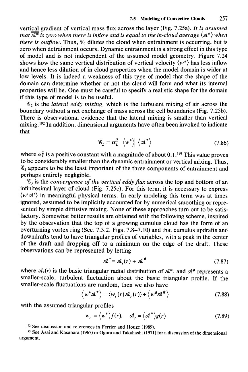
(7.86)
(7.89)
where ai is a positive constant with a magnitude of about 0.1.
193
This value proves
to be considerably smaller than the dynamic entrainment or vertical mixing. Thus,
'i8
2
appears to be the least important of the three components of entrainment and
perhaps entirely negligible.
'i8
3
is the convergence
of
the vertical eddy flux across the top and bottom of an
infinitesimal layer of cloud (Fig. 7.25c). For this term, it is necessary to express
(w'.cA')
in meaningful physical terms. In early modeling this term was at times
ignored, assumed to be implicitly accounted for by numerical smoothing or repre-
sented by simple diffusive mixing. None of these approaches turn out to be satis-
factory. Somewhat better results are obtained with the following scheme, inspired
by the observation that the top of a growing cumulus cloud has the form of an
overturning vortex ring (Sec. 7.3.2, Figs. 7.8-7.10) and that cumulus updrafts and
downdrafts tend to have triangular profiles of variables, with a peak in the center
of the draft and dropping off to a minimum on the edge of the draft. These
observations can be represented by letting
.cA
*=
.cA
r(
r)
+
.cA
# (7.87)
where
.cAr(r)
is the basic triangular radial distribution of sl"; and
.cA#
represents a
smaller-scale, turbulent fluctuation about the basic triangular profile. If the
smaller-scale fluctuations are random, then we also have
(w*.cA*)
= (Wr(r).silr(r)) + (w#.sil#) (7.88)
with the assumed triangular profiles
w
r
= (w*)j(r),
.sil
r
= (.cA*)g(r)
192 See discussion and references in Ferrier and Houze (1989).
193 See Asai and Kasahara (1967)or Ogura and Takahashi (1971)for a discussion of the dimensional
argument.
258 7 Cumulus Dynamics
Thus
(w*dl*)
=
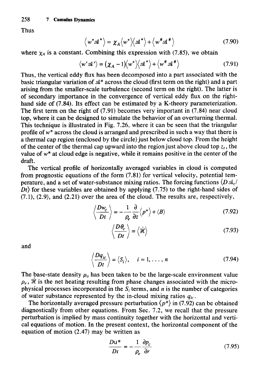
XA(w*)(dl*)+(w#dl#)
where
XA
is a constant. Combining this expression with (7.85), we obtain
(7.90)
(7.91)
Thus, the vertical eddy flux has been decomposed into a part associated with the
basic triangular variation of
dl* across the cloud (first term on the right) and a part
arising from the smaller-scale turbulence (second term on the right). The latter is
of secondary importance in the convergence of vertical eddy flux on the right-
hand side of (7.84). Its effect can be estimated by a K-theory parameterization.
The first term on the right of (7.91) becomes very important in (7.84) near cloud
top, where it can be designed to simulate the behavior of an overturning thermal.
This technique is illustrated in Fig. 7.26, where it can be seen that the triangular
profile of
w* across the cloud is arranged and prescribed in such a way that there is
a thermal cap region (enclosed by the circle)
just
below cloud top. From the height
of the center of the thermal cap upward into the region
just
above cloud top z., the
value of
w* at cloud edge is negative, while it remains positive in the center of the
draft.
The vertical profile of horizontally averaged variables in cloud is computed
from prognostic equations of the form (7.81) for vertical velocity, potential tem-
perature, and a set of water-substance mixing ratios. The forcing functions
(Vdlcl
Vt)
for these variables are obtained by applying (7.75) to the right-hand sides of
(7.1), (2.9), and (2.21) over the area of the cloud. The results are, respectively,
(
DW
e
)
1 a/
*)
- =
---\p
+ (B)
Dt P
e
az
(0;;
)=
(oJe)
(7.92)
(7.93)
and
(7.94)
(7.95)
Dt
The base-state density
Po
has been taken to be the large-scale environment value
Pe,
'if
is the net heating resulting from phase changes associated with the micro-
physical processes incorporated in the
S, terms, and n is the number of categories
of water substance represented by the in-cloud mixing ratios
qic'
The horizontally averaged pressure perturbation (p*) in (7.92) can be obtained
diagnostically from other equations. From Sec. 7.2, we recall that the pressure
perturbation is implied by mass continuity together with the horizontal and verti-
cal equations of motion. In the present context, the horizontal component of the
equation of motion (2.47) may be written as
Du*
1
aPe
=---
P
e
ar
