Graziani F. (editor) Computational Methods in Transport
Подождите немного. Документ загружается.

Reflectance Modeling with Turbid Medium Radiative Transfer 203
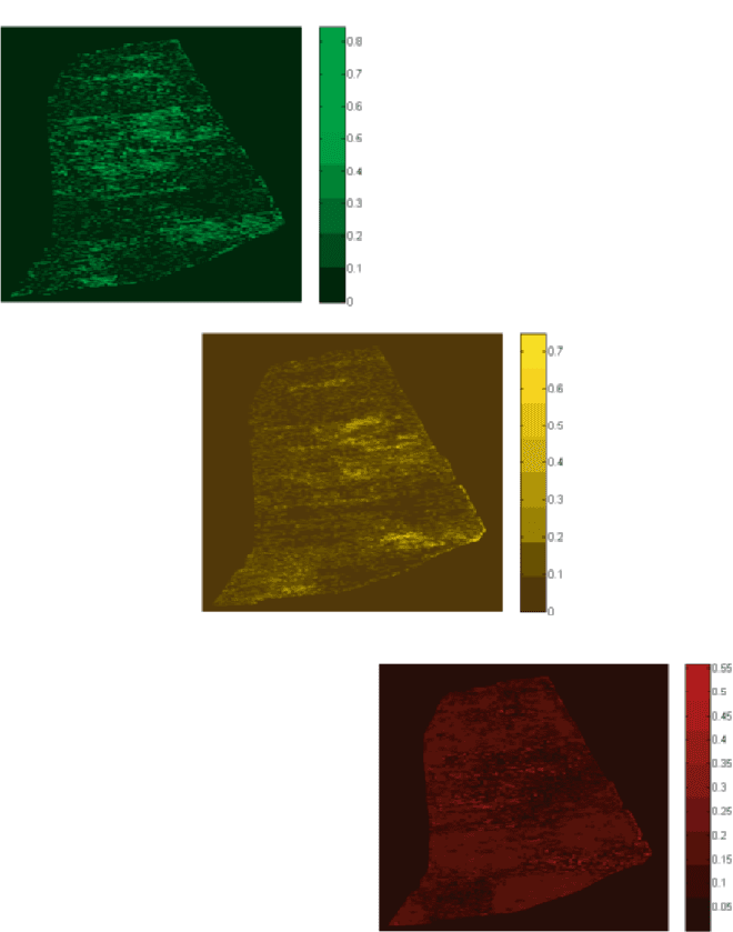
Fig. 24. Predicted green/yellow/red cherry distributions. (Field 408 Block 4)
204 Barry D. Ganapol
550nm
1234
1
2
3
4
5
6
7
0.025
0.026
0.027
0.028
0.029
0.030
0.031
0.032
680nm
1234
1
2
3
4
5
6
7
0.045
0.050
0.055
0.060
800nm
1234567
1
2
3
4
5
6
7
0.0115
0.0120
0.0125
0.0130
Degree of Linear
Polarization (Dp0)
at TOC
LAI = 2
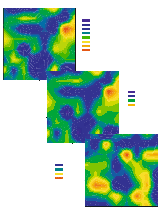
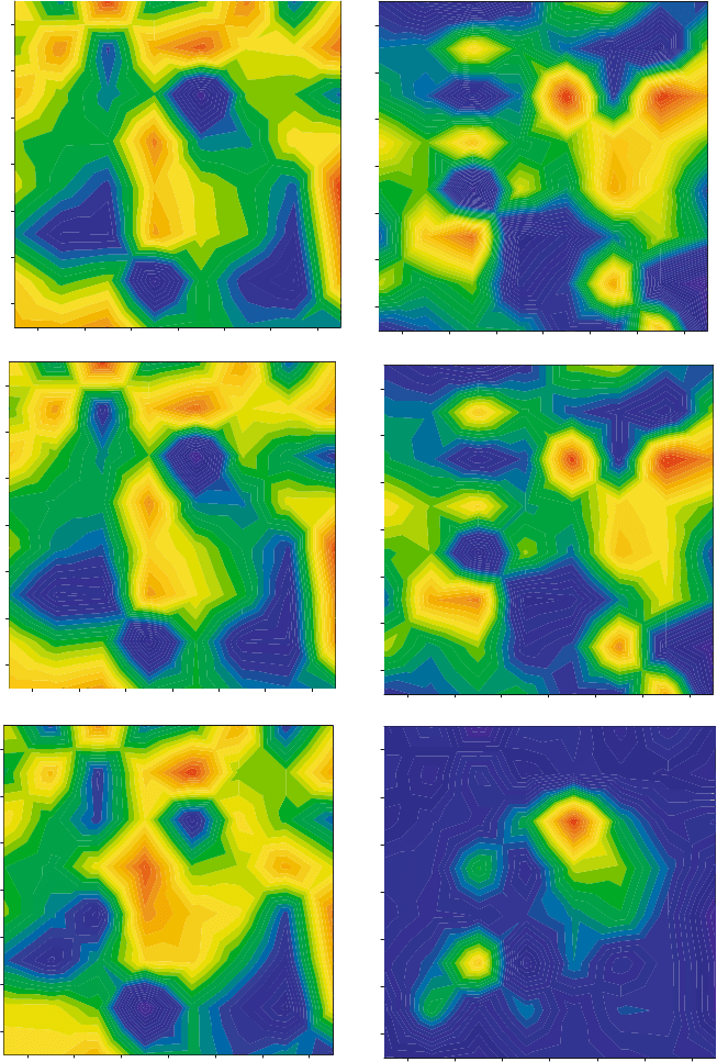
Fig. 25. Canopy reflectance for scene with a random LAD
Reflectance Modeling with Turbid Medium Radiative Transfer 205
12345
1
2
3
4
5
6
7
1234
1
2
3
4
5
6
7
1234567
1
2
3
4
5
6
7
ρ
Τ
T
= 0.1 Soil
ρ
Τ
= 0.3 T-72
P
T
= 1
Reflectance/I
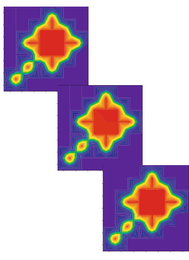
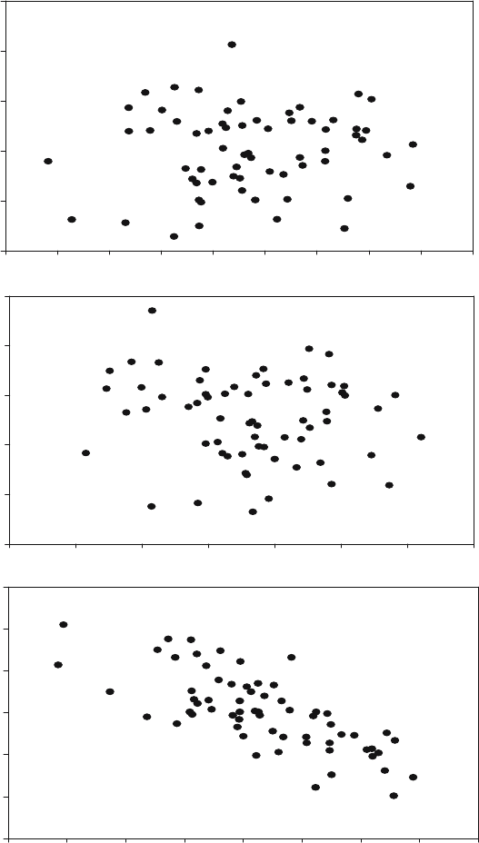
Fig. 26. T-72 tank in the clear
206 Barry D. Ganapol
1234567
1
2
3
4
5
6
7
Reflectance/I
1234567
1
2
3
4
5
6
7
1234567
1
2
3
4
5
6
7
Dp0
Contour Graph 3
X Data
Y Data
Contour Graph 4
Y Data
X Data
X Data
Y Data
Contour Graph 2
Contour Graph 7
Contour Graph 6
Contour Graph 5
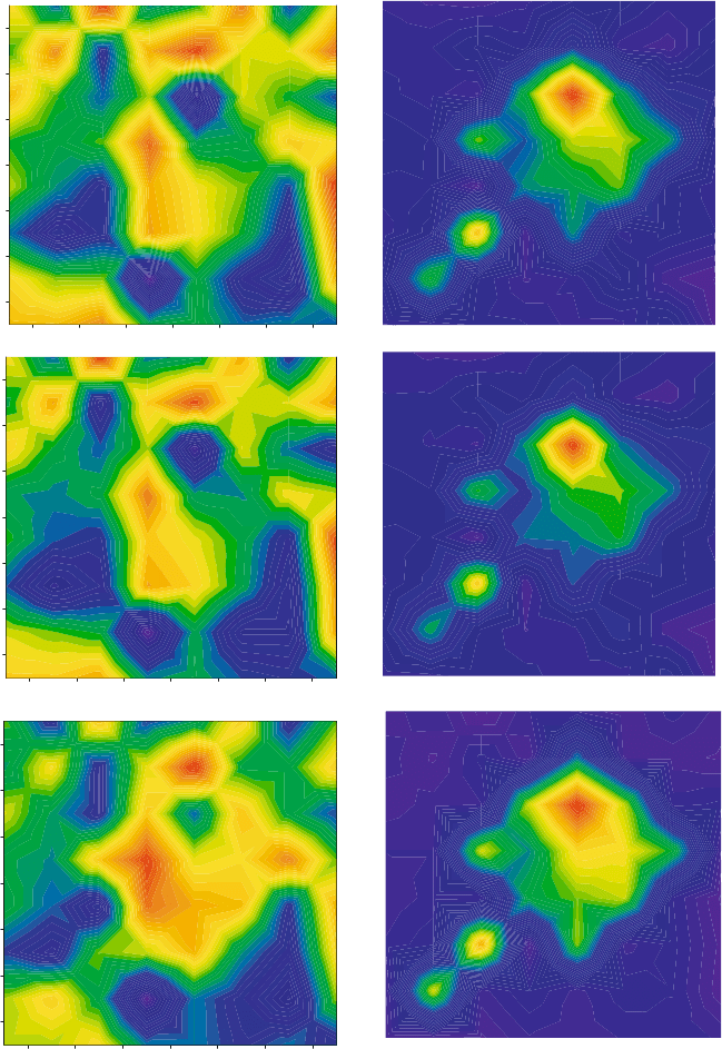
Fig. 27a. T-72 under foiliage of LAI = 4
Reflectance Modeling with Turbid Medium Radiative Transfer 207
1234567
1
2
3
4
5
6
7
1234567
1
2
3
4
5
6
7
1234567
1
2
3
4
5
6
7
1234567
1
2
3
4
5
6
7
1234567
1
2
3
4
5
6
7
1234567
1
2
3
4
5
6
7
Contour Graph 3
X Data
Y Data
X Data
Contour Graph 10
X Data
Y Data
X Data
Contour Graph 9
Y Data
Y Data
Contour Graph 2
X Data
Y Data
Contour Graph 1
X Data
X Data
Y Data
Contour Graph 8
Reflectance/I Dp0
Fig. 27b. T-72 under foiliage of LAI = 6
208 Barry D. Ganapol
0.40 0.41 0.42 0.43 0.44 0.45 0.46 0.47 0.48
0.040 0.041 0.042 0.043 0.044 0.045 0.046 0.047
0.086 0.088 0.090 0.090 0.094 0.096 0.098 0.100 0.102 0.104
Dp0
R
f
0.024
0.026
0.028
0.030
0.032
0.034
0.040
0.045
0.050
0.055
0.060
0.065
0.0105
0.0110
0.0115
0.0120
0.0125
0.0130
0.0135
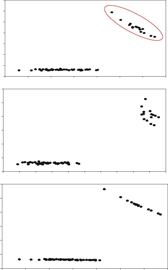
Fig. 28a. Dp0 versus R
f
for original scene
Reflectance Modeling with Turbid Medium Radiative Transfer 209
0.36 0.38 0.40 0.42 0.44 0.46 0.48 0.50
0.00
0.02
0.04
0.06
0.08
0.10
0.032 0.034 0.036 0.038 0.040 0.042 0.044 0.046 0.048 0.050 0.052
0.075 0.080 0.085 0.090 0.095 0.100 0.105 0.110
T-72
Dp0
R
f
0.12
0.0
0.1
0.2
0.3
0.4
0.5
0.00
0.05
0.10
0.15
0.20
0.25
0.30
0.35
0.6
Fig. 28b. Dp0 versus R
f
for with T-72 in an LAI = 6 canopy
210 Barry D. Ganapol
References
1. B. Hapke and E. Wells, J. Geophys Res., 86(B4), 3055–3060, (1981).
2. M. Minnaert, Astrophys. Jour., 93, 403–410 (1941).
3. C. Walthal, et. al., Appl. Opt., 24(4), 383–387 (1985).
4. J. Ross, The Radiation Regime and Architecture of Plant Stands, W. Junk, The
Hague, Netherlands (1981).
5. B. Ganapol ,et. al., Rem. Sens. Environ. 70:153–166 (1999).
6. B. Ganapol, et. al., Rem. Sens. Environ. 63:182–193 (1998).
7. C. Siewert, Nucl. Sci. & Eng., 69, 156–160 (1979).
8. B. Hosgood, et. al. European Commission, Joint Research Centre, Institute for
Remote Sensing Applications, Report EUR 16095 EN (1995).
9. L. Grant, C. Daughtry., and V. Vanderbilt., Envir. Exp. Bot. 27,139–145
(1987).
10. E. Larsen and W.F. Miller, Nucl. Sci. & Eng., 73, 76–83 (1980).
11. F. Press, Numerical Recipes, Cambridge Press, (2001).
12. W. Abbott and E. Allen, Nucl. Sci. & Eng., 108, 278–288 (1991).
Rayspread: A Virtual Laboratory for Rapid
BRF Simulations Over 3-D Plant Canopies
Jean-Luc Widlowski, Thomas Lavergne, Bernard Pinty, Michel Verstraete
and Nadine Gobron
Institute for Environment and Sustainability, Joint Research Centre, TP. 440, Via
E. Fermi 1, 21020 Ispra (VA), Italy
Jean-Luc.Widlowski@jrc.it
Accurate knowledge of the spatial (and temporal) variability of the biosphere’s
characteristics is useful not only to address critical scientific issues (climate
change, environmental degradation, biodiversity preservation, etc.) but also
to provide appropriate initial state and boundary conditions for general cir-
culation or landscape succession models. In particular, the 3-D structure of
vegetation emerged as a crucial player in processes affecting carbon seques-
tration, landscape dynamics and the exchanges of energy, water and trace
gases with the atmosphere e.g., [BWG04]. The growth and development of
plant architecture, in turn, are primarily conditioned by effective interception
of solar radiation that provides the necessary energy for photosynthesis and
other physiological processes [VB86].
In this context, space borne, optical remote sensing provides a conve-
nient, efficient and cost-effective way to acquire information on the state of
terrestrial vegetation, over large areas and at spatial resolutions adequate
to address many key ecological and climate change related issues. The physi-
cal interpretation of such remote sensing measurements, however, can provide
reliable quantitative information only on the relevant state variables that con-
trol the interactions of the radiation field with all intervening media from the
light source to the detector e.g., [VPM96]. The simulation of such processes,
using physically based radiative transfer (RT) models, thus allows to esti-
mate the most probable value of a remote sensing measurement, given that
the values of all state variables in the model, the conditions of observation
and the nature and role of all relevant radiative processes in the system are
specified in advance. This modeling approach is known as the direct or for-
ward mode, and can be used, for example, to determine which state variable
in a given model is primarily responsible for the observed signal variabil-
ity under specific condition of observation and illumination. It also provides
ample testing ground for the intercomparison of different radiation transfer
models [PWT04].
The interpretation of remote sensing data requires applying the same
model in inverse mode, or more specifically inverting the model against the
data set, in order to retrieve the state variables of interest [GS83, KKP00].
At the Earth’s surface, the spectral, directional and polarization signatures
212 J.-L. Widlowski et al.
of the various scattering elements, together with their number, geometry and
spatial distribution, are responsible for the radiative characteristics of the re-
flected electromagnetic signal in the optical part of the solar spectrum. Fur-
thermore, the conditions of observation and illumination, as well as the state
of the atmosphere at the time of measurement, may significantly alter the
reflectance values of terrestrial surfaces. State of the art inversion techniques
involve the pre-computing of reflectance fields (and/or related quantities) for
a pre-selected ensemble of likely canopy structures and under a wide vari-
ety of possible scenarios of illumination and observation geometries. These
look-up-tables (LUT) can then be searched to identify the best-matching
candidate capable of explaining the entire string of available (multi-spectral
and/or -directional) remote sensing data. Such approaches reduce the amount
of retrievable solutions to the inversion but require (1) the availability of de-
tailed knowledge regarding typical canopy architectures (in particular the
size, shape, and number of leaves, branches and crowns) as well as their tem-
poral evolutions, (2) a RT model capable to actually represent such complex
3-D structures, and (3) the accurate and reliable simulation of the reflectance
fields for these canopy representations under all envisaged spectral, viewing
and illumination conditions.
This contribution will provide a concise description of the major RT char-
acteristics in plant canopies. Following this, the Rayspread model will be pre-
sented, which addresses the need for rapid, yet accurate, simulations of the
reflectance field over arbitrarily complex plant environments. Validation and
verification of this model are followed by a small case study on the impact of
woody structures on the directional signatures of vegetation canopies.
1 Canopy Radiation Transfer Fundamentals
The radiative transfer equation is a statement of the law of energy conser-
vation [Cha60]. Under steady state conditions and neglecting any polariza-
tion, diffraction and emission effects, its integro-differential form describes the
change in the intensity I [W m
−2
sr
−1
] of monochromatic radiation travelling
in direction Ω at some location r:
Ω •∇I(r, Ω)+˜σ
e
(r, Ω, Ω
0
) I(r, Ω)=
4π
˜σ
s
(r, Ω
→ Ω) I(r, Ω
) dΩ
(1)
Variations in intensity are thus either due to radiation – originally travelling
in direction Ω – being intercepted by the foliage (second left hand term),
or else, due to radiation being scattered from some direction Ω
into the
direction of interest Ω at location r (right hand term). More specifically, ˜σ
e
[m
−1
] is the extinction coefficient, which indicates the loss in intensity due
to absorption and scattering of radiation away from Ω,and˜σ
s
[sr
−1
]isthe
differential scattering coefficient for photons scattered from some direction
Ω
into a unit solid angle about direction Ω at point r. For the purpose of