Gates Charles. Ancient Cities: The Archaeology of Urban Life in the Ancient Near East and Egypt, Greece and Rome
Подождите немного. Документ загружается.


22 THE NEAR EAST AND THE EASTERN MEDITERRANEAN
The fourth and last has been called the “Terrazzo Building.” Its large single room featured a
well-prepared floor, a very hard layer 40cm thick of polished cobbles and pinkish lime, this last
made by burning limestone. Linear patterns were created by white stones set into the floor. Such
“terrazzo” floors have been found elsewhere, but after this period the technique was forgotten
until the Iron Age some 5,000 years later.
In Subphase 6, the Large-room Building subphase, the character of the village changed dramati-
cally. The settlement became smaller. Communal buildings were absent, and the Plaza was used
as a refuse dump. Houses consisted of one or two large rooms only. Clearly some major social
change happened at Çayönü; further evidence for change has come from the economic data, as
noted below.
The Pottery Neolithic (Phase II), ca. 6000–5000 BC, is defined by the sudden appearance of pot-
tery, a technique assumed to be imported from outside because no beginning, experimental
stages have been identified. The settlement continues from before, without dramatic break, but
now the neat arrangement of buildings originally established during the Grill Plan subphase
(Subphase 2) is replaced by the clustering of irregularly shaped houses along narrow streets.
Communal buildings continue to be absent.
As for the economy of Neolithic Çayönü, the excavations have documented the evolution of
a village economy from food collection into food production over this continuously inhabited
period of 3,000 years. During Subphases 1–5, the villagers depended on the collecting of wild
plants and the hunting of wild animals. The cultivation of pulses, lentils, and vetch, followed by
the addition of Einkorn wheat, offered supplements to the diet. Only in the later PPNB, in Sub-
phase 5, did this pattern change. Domesticated sheep and goat then appeared in great numbers,
becoming a dietary staple. The hunting of wild animals diminished considerably.
Çayönü has yielded striking evidence for early metallurgy. Native copper and malachite, found
nearby, were worked in Subphase 2, with an intensification in metallurgy in Subphases 3 and
4; subsequently, metalworking declined. The ore was hammered unheated to create such tools
as pins, hooks, and drills – a simple start to a technology that would later prove so important.
Annealing was also practiced: heating, but not smelting, of copper lumps to shape them more
easily. The finds at Çayönü count among the earliest known use of metal in the Near East.
Other crafts were practiced as well, such as bead making and weaving. A cloth impression
made of domestic linen gives early evidence in the Near East for the craft of weaving. The pres-
ence of obsidian and sea shells, used for tools and decoration, indicates long-distance trade.
Not known is whether or not the artisans of Çayönü practiced their crafts full time. If they did,
they fulfill Childe’s third criterion for the city, “occupations other than farming.” Other factors
on Childe’s list present at Çayönü may include social stratification (as noted above) and monu-
mental public architecture. But other elements of his definition are absent. What the excavations
of Çayönü have revealed to us is the gradual appearance during the Neolithic period of certain
features of social life that will eventually coalesce into the fully developed city of the later fourth
and third millennia BC.
GÖBEKLI
.
TEPE: AN EARLY NEOLITHIC CEREMONIAL
CENTER
A sensational discovery of recent years that raises fascinating questions about the role of ideology
in the material world of early Neolithic people is the ceremonial center at Göbekli Tepe, 15km
north-east of S¸anlıurfa in south-eastern Turkey (Figures 1.7 and 1.8). Excavated since 1995 by a
NEOLITHIC TOWNS AND VILLAGES 23
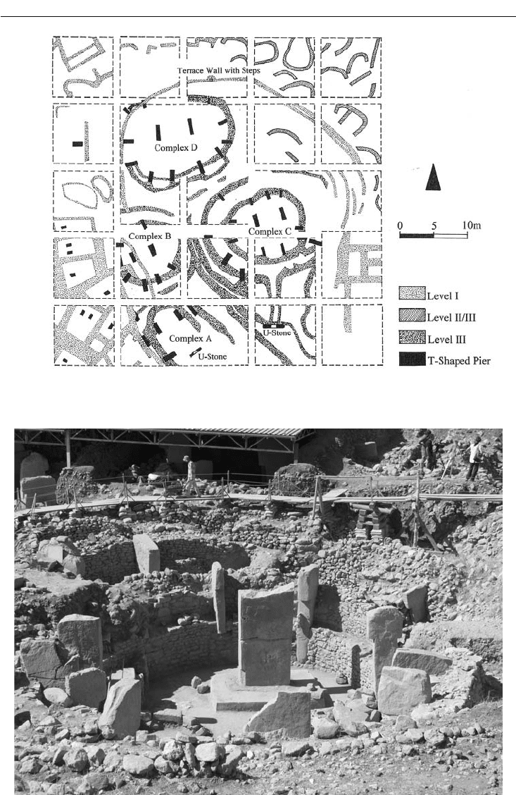
Figure 1.7 Plan, Central area (in 2007), Göbekli Tepe
Figure 1.8 Complex C (foreground) and Complex B, Göbekli Tepe
24 THE NEAR EAST AND THE EASTERN MEDITERRANEAN
team from the German Archaeological Institute and the S¸anlıurfa Museum under the direction
of Klaus Schmidt, this dramatic hilltop site consists of a series of at least twenty circular rooms
placed on its south and west slopes. The rooms are well preserved because they were deliberately
“buried” with fill up to the original height of the building.
The rooms are formed by a stone wall, sometimes by a series of concentric walls. In some,
large, monolithic T-shaped stone piers are placed at right angles in the wall as reinforcements
and roof supports. Two piers, also monolithic, T-shaped, very tall, and rectangular in section, are
typically found in the center of a room as additional supports for the roofing. These rooms may
have been embedded in the ground, Schmidt has speculated, with entrance from the roof, like
kivas, the subterranean ceremonial rooms of the Pueblo Indians of the south-west United States.
The largest of the excavated rooms is Complex C, measuring in diameter 12m (interior) to 30m
(the outermost of its four concentric walls). Its piers are 5m in height.
The central piers and many of those placed in the enclosing walls are typically decorated with
relief sculpture depicting a frightening array of predatory animals, birds, and insects, such as
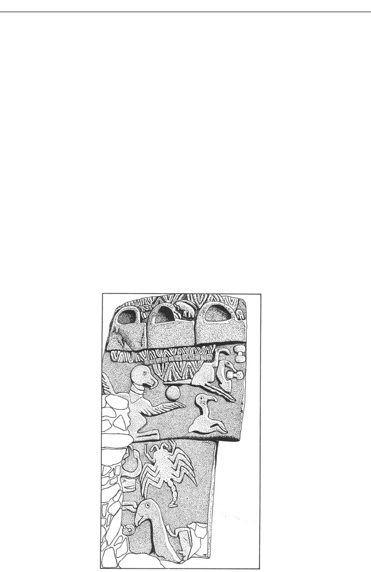
lions, foxes, vultures, snakes, and scorpions (Figure 1.9). Some piers, with long, thin arms carved
on each side, the hands meeting on the narrow front side, seem to represent humans. The mean-
ing of these images must be connected to the rituals celebrated and the ideology that underlay
them, whatever they may have been.
The absence of any established settlement, at least in the early level (Level III) represented by
these circular complexes, makes it clear that this was a cult or ceremonial center. Beyond that,
Figure 1.9 Partially excavated Stele from Complex D, Göbekli Tepe

NEOLITHIC TOWNS AND VILLAGES 25
much about Göbekli Tepe is still uncertain. The circular complexes were built at different times,
it is thought, but at what intervals and by whom? The commanding view of the countryside from
this hilltop suggests that the center was developed and patronized by people from a large region.
Who were these people? Were they villagers, nomads, or hunter-gatherers? Who organized the
huge amount of labor involved in the quarrying, carving, and construction?
As for the chronology of the site, Level III is placed in PPNA (Pre-Pottery Neolithic A; see
above, under “Jericho”).The subsequent Level II, with smaller circles, small oval huts, and rect-
angular houses, is assigned to PPNB. Based on C14 results, Schmidt has dated Level III to the
late tenth millennium BC, Level II to the nineth millennium BC. These absolute dates are contro-
versial; for some scholars, they seem too early.
The only site yet known with comparable features, such as monolithic piers with sculpted
images, is Nevalı Çori, a PPNB settlement with cult center located on the east shore of the
Euphrates River. Excavated in 1993, this site now lies below the lake formed behind the Atatürk
Dam. The distance between Göbekli Tepe and Nevalı Çori is 70km. It may be that within this
radius from Göbekli Tepe, other sites with similar cultic features once thrived in the Early
Neolithic period. Further information is eagerly awaited.
ÇATALHÖYÜK
Trends of the Neolithic period discussed above – developments in town planning, architecture,
agriculture (including animal husbandry), technology, and religion – come together dramatically
at Çatalhöyük (western Turkey, near Konya), in twelve well-preserved building levels dated ca.
6500–5500 BC. The site lies in the Konya plain, in a favorable environmental setting. Geomor-
phological study has revealed that in Neolithic times the town stood near a river, a lake, and
marshes, with hills not far off. The site consists of two adjacent mounds, east and west. The east-
ern mound contains the Neolithic remains that interest us here, whereas the western mound has
later occupation, Early Chalcolithic. The eastern mound measures over 13ha, unusually large for
this period. Only 0.4ha was excavated in the early 1960s by James Mellaart of the British Institute
of Archaeology at Ankara, but current investigations, begun in 1993 under the direction of Ian
Hodder, now at Stanford University, are expanding the area exposed.
The appearance of the town recalls the Native American pueblos of the south-west United
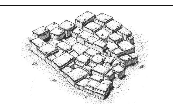
States and is otherwise unattested in the Ancient Near East (Figure 1.10). Houses were made
of mud brick, often with a framework of wooden pillars and beams. The flat roofs consisted of
clay on top of a network of wood. The houses clustered together, their walls touching those of
their neighbors. Although small courtyards connected by streets lined the edges of the excavated
area, within the cluster courts existed but streets did not. People entered houses from the flat
rooftops, descending to the floor by means of a ladder. Since the town lay on sloping ground, the
height of the roofs varied. Could this honeycomb arrangement have been intended as a system of
defense? Was it used throughout the site, or just in this excavated neighborhood? Some of these
questions may be answered by the new excavations.
The rather small interior of a typical house consisted of a main room with an adjacent storeroom,
together making up a maximum 30m
2
of floor space. It is hypothesized that small windows high
up in the walls provided light and, together with the usual hole in the roof, allowed smoke from
the hearth and ovens to escape. Each house contained at least two low platforms, with a raised
bench at one end of the main platform. The built-in “furniture” must have led to a division of the
room for different purposes, for work or for leisure. In addition, the bones of the dead were buried
26 THE NEAR EAST AND THE EASTERN MEDITERRANEAN
beneath these platforms, perhaps after the bodies had been exposed outside the settlement, the
flesh removed by vultures. One exceptional burial contained the remains of a young woman hold-
ing a plastered skull whose face was painted red. As at Jericho, the presence of ancestors beneath
the floors of a house may have been a way for early agriculturalists to mark eternal possession of the
land, to legitimize their occupation. Such intramural burials contrast sharply with the later Classical
practice of scrupulously keeping cemeteries outside the city walls: for the Greeks and the Romans,
the dead menaced and polluted the land of the living and had to be kept at a distance.
Organic remains were unexpectedly well preserved at the time of Mellaart’s excavations,
thanks to the high water table. Recently, because of developments in the local farming industry,
the water table has dropped dramatically; archaeological preservation may be adversely affected.
Plants grown at Çatalhöyük included cereals (such as barley and wheat), nuts (pistachios and
almonds), and legumes (peas and bitter vetch). The largely vegetarian diet was supplemented by
beef, sheep, and goat. Analysis of the cattle bones has revealed that cattle were domesticated,
among the earliest examples yet known from West Asia. Wild animals hunted include red deer,
boar, wild cattle, and sheep (although traces of woollen textiles show the presence of domesti-
cated sheep, wool being a product of domesticated animals).
The residents of Çatalhöyük included accomplished craftsmen. Beautiful pressure-flaked
obsidian spearheads and arrowheads and flint daggers attest to the skill of the makers of chipped
stone tools. The finding of lead pendants and copper slag indicates knowledge of metallurgy.
Pottery, always handmade without recourse to a potter’s wheel, occurs from the earliest levels,
but finds of wooden bowls, cups, and boxes remind us that containers of normally perishable
materials (skins and basketry as well as wood) played an equally important role in daily life. Frag-
ments of woollen and perhaps flaxen textiles, like the wooden items preserved by burning, are
unusually early examples. Patterns used in weaving may be depicted in the wall paintings here.
Çatalhöyük participated in an extensive trade network, with obsidian a key commodity.
Much obsidian was found here, not surprising with nearby sources in central Anatolia, near the
volcanoes Karaca Dag˘ and Hasan Dag˘. Items from farther distances include Mediterranean sea
shells, valued especially as beads, and turquoise from the Sinai.
Figure 1.10 Houses (reconstruction), Çatalhöyük
NEOLITHIC TOWNS AND VILLAGES 27
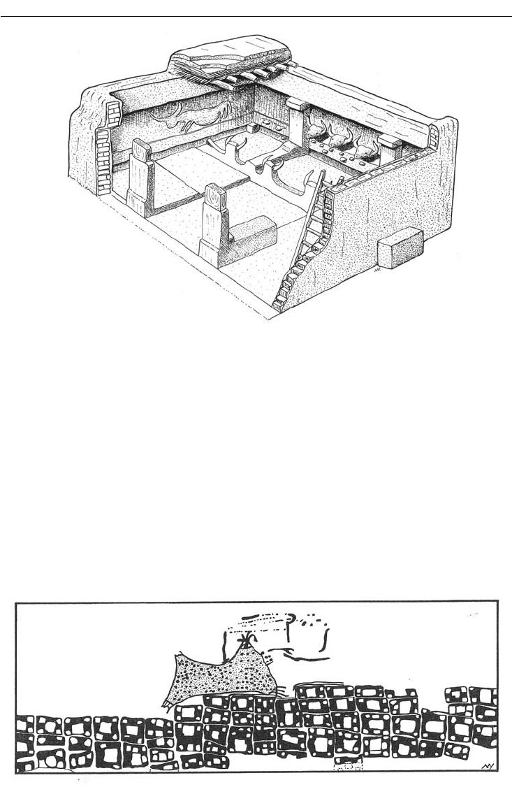
Evidence for religious practices is abundant. Over forty houses scattered through the many
building levels have been identified as shrines. While their plans do not differ from those of
regular houses, their decoration does. Craftsmen appointed these particular rooms with wall
paintings, relief sculpture, free-standing figures, and the actual horns of bulls and caprines and
jaws of foxes (Figure 1.11).
The wall paintings are of exceptional interest for their depictions of life in a Neolithic town.
Some walls have up to 100 layers of plaster, any of which might bear paintings – quite a chal-
lenge for the conservators. The technique of painting consisted of natural pigments mixed with
fat and applied on a background of white plaster. Subjects included the textile patterns already
mentioned, vultures attacking headless humans, cattle and deer hunts, and wild bulls relent-
lessly pursued by humans. One wall painting shows a stylized depiction of what may be a town
beneath an erupting volcano (Figure 1.12). Certain paintings were three-dimensional, reliefs built
Figure 1.11 House shrine (reconstruction), Çatalhöyük
Figure 1.12 Erupting volcano and town, wall painting, Çatalhöyük. Museum of Anatolian Civilizations,
Ankara
28 THE NEAR EAST AND THE EASTERN MEDITERRANEAN
up from plaster. They depict bull or ram
heads (often with real horns incorporated
into the relief), occasionally leopards, and
a bear (formerly identified as a female
figure).
Free-standing figures similarly empha-
size the magical power of animals and
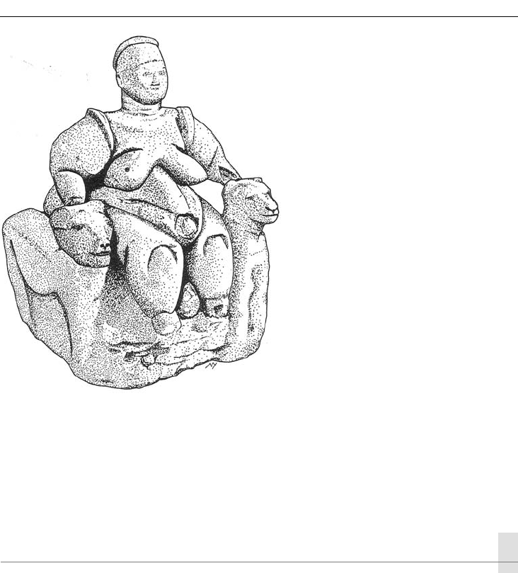
the desire for fertility. The figurine of a
massive woman (a goddess?) expresses
these beliefs to great effect (Figure 1.13).
Seated between two leopards (or pan-
thers), the woman is in the process of
giving birth. For ancient men and women
her obesity must have denoted abundant,
dependable food sources. Her prosperity,
her fecundity, and her mastery over wild
animals made her a symbol of much that
Neolithic people wished to attain.
To reconstruct the religious practices of the inhabitants of Çatalhöyük, we must rely on anal-
ogy with practices attested for later literate cultures and for those recorded by modern ethnogra-
phy. The striking images provided by the paintings and sculpture of Çatalhöyük tempt us to be
concrete in our interpretations. But we should be cautious. We must keep reminding ourselves
that the beliefs of people who lived 7,500 years ago still lie largely in shadow.
THE DEVELOPMENT OF CHIEFDOMS AND STATES
Çatalhöyük has seemed so remarkable in part because when it was initially excavated, its cultural
context was largely unknown, with little research available to evaluate contemporary settlements
in the area. Subsequent projects in central and south-eastern Turkey (such as Çayönü), Syria,
Iraq, and Iran have been fi lling in the picture. Nonetheless, Çatalhöyük, with its exceptional
preservation, gives us in a still distinctive way an idea of what other Neolithic towns and villages
may have looked like.
With the abandonment of Çatalhöyük in the mid-sixth millennium BC, the striking innova-
tions of central Anatolia came to a halt. Villages continued in the region, but for important
developments our focus shifts eastward to Mesopotamia. The next 2,000 years, the Halaf and
Ubaid periods, witnessed the gradual evolution of the Neolithic communities into chiefdoms
and states, both centralized political systems, culminating in the great urban civilization of the
Sumerians. A chiefdom is a political system in which a single ruler, a chief, exercises authority
over two or more local groups, his power distributed downward through a ranked hierarchy of
subordinates. The state is a more formal system, with power invested in a centralized govern-
ment, a combination of economic, military, legal, and ideological institutions. The state is able to
Figure 1.13 Seated fat woman (goddess?),
terracotta figurine, Çatalhöyük. Museum of
Anatolian Civilizations, Ankara

NEOLITHIC TOWNS AND VILLAGES 29
regulate its affairs in an impersonal way, and can use force, can mete out punishments in order
to support its decisions. Social stratifi cation is a characteristic feature of the state, as indeed it is
of the chiefdom.
Although the precise nature of the development of Near Eastern society during the Halaf and
Ubaid periods is controversial, the broad outlines seem clear. Social organization was varied. In
some towns an egalitarian society was the norm, with no groups holding special privileges, but
elsewhere, economic and social hierarchies emerged, whereby some members of the community
enjoyed more status, privileges, and possessions than others. Eventually hierarchy would prevail.
Management of food sources seems to have been responsible for this, with excess production,
which can be stored and sold or traded, providing accumulated wealth and power for some.
Religion may have offered an ideological justifi cation for such inequality. These periods were
marked in addition by innovations in technology (wheel-made pottery, sheet metal), transpor-
tation (boats with sails), and agriculture (tree crops). Trade networks continued, as the broad
distribution of Halaf and Ubaid pottery indicates, from Mediterranean Turkey to Iran. Little by
little the technological, commercial, and social world of the Ancient Near East was preparing
itself for the rise of full-fl edged cities.
CHAPTER 2
Early Sumerian cities
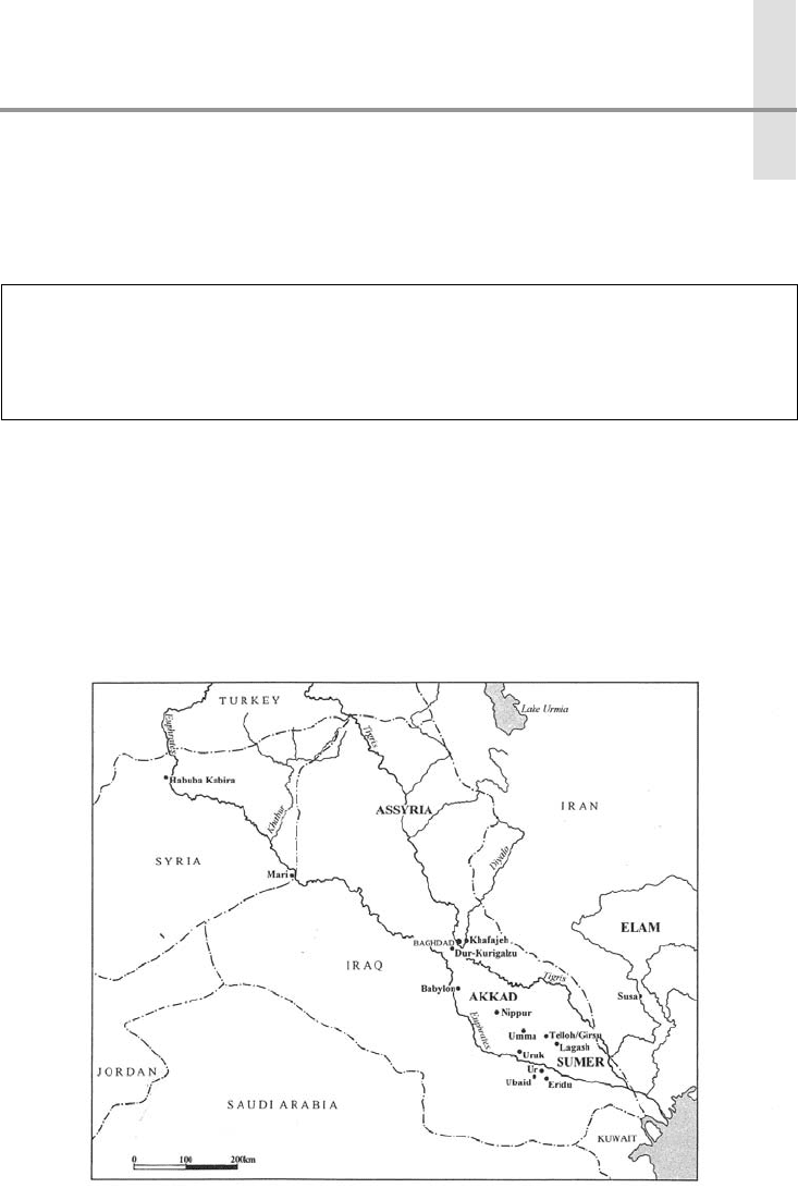
The first cities in the Near East–Mediterranean basin appeared in southern Mesopotamia, or
Sumer, the creation of a people we call the Sumerians (Figure 2.1). We have seen that environ-
mental changes in south-west Asia during the previous 5,000 years led to human control over
food production; with this mastery came major social changes, including fixed settlements. The
socio-economic development of these towns and villages is marked by the gradual appearance
of the ten criteria proposed by Childe as a mark of the true city. All ten factors finally emerge in
Sumer during the later fourth millennium BC.
Ubaid period: ca. 5000–3500 BC
Protoliterate (Uruk) period: ca. 3500–2900
BC
Early Dynastic period: ca. 2900–2350 BC
Figure 2.1 Mesopotamia: Bronze Age cities

EARLY SUMERIAN CITIES 31
This chapter will explore early Sumerian cities. We will want to ask why true cities originated
in southern Mesopotamia, a small region that did not figure in the Fertile Crescent and the Ana-
tolian–Zagros highlands, areas so important for the domestication of plants and animals. What
factors led the Sumerians to develop writing, the tool that propelled their settlements into the
rank of “city”? What characterized the Sumerian city, and how did it compare and contrast with
the Neolithic towns presented in Chapter 1? As examples, we shall inspect in particular the city
of Uruk and its northern colony at Habuba Kabira. Aspects of two additional cities will also be
examined: the Temple Oval, an important religious complex at Khafajeh; and the Royal Tombs of Ur,
a spectacular group of burials from the Early Dynastic III period, found intact. But first, before
we turn to Uruk, some background information about the Sumerians is needed.
THE SUMERIANS AND THEIR ENVIRONMENT
The Sumerians, the known inhabitants of southern Mesopotamia from the fourth into the early
second millennia BC, are so called after the ancient Akkadian name for this region, “Shumer.”
Thanks to their writing, invented during the fourth millennium BC, far more is known about the
Sumerians than about their anonymous predecessors of the Neolithic age. The survival of the
clay tablets on which they wrote together with the remains of their cities allow us to trace with
greater confidence the increasing complexity of society in the ancient Near East.
The Sumerians stand alone in human history. Their language has no known relatives, and their
architecture and artifacts do not indicate ethnic ties with cultures of other regions. The continu-
ity of the material remains at their cities suggests, however, that the Sumerians had already settled
in southern Iraq in the later Neolithic period, at the end of the sixth millennium BC, well before
they developed the art of writing. This era of the earliest known settlements in the region is
called the Ubaid period, named after a site that has yielded a good sample of these early remains.
Subsequent periods are the Protoliterate or Uruk period (when the city of Uruk was dominant);
then the Early Dynastic period, divided into three parts (abbreviated as ED I, II, and III), during
which the Sumerian city-states became increasingly prosperous.
Cities are a distinctive feature of the Sumerians. Indeed, the independent, self-governing
city was their basic political unit. In this respect Sumer resembles ancient Greece, as we shall
see. Geography seems not to be the determining factor in this political development, for the
landscape of Sumer is flat, its terrain marked only by rivers and canals, whereas Greece is
divided by mountains and valleys. Instead, religious reasons seem responsible. Each Sume-
rian city-state nominally belonged to a god or goddess. The temple, the house of the divinity,
was thus the focus of both ritual and economic activity. It also became the regional admin-
istrative center. Each town that grew around such a temple was entrusted, on behalf of the
presiding deity, to the care of a mortal king (lugal, in Sumerian) or viceroy (ensi). Kingship first
began in the city of Eridu, according to Sumerian myth. The institution was later copied and
spread to other towns. The city-state, then, originated in remote, heroic times, the work of the
gods; the divinely sanctioned city-state would be for the Sumerians the basic unit of political
organization.
Rivalries between cities grew intense in the Early Dynastic period, thanks to territorial disputes
in this region where agricultural land was precious. Warfare drove people from the countryside
into the cities, now well protected with serious fortifications. No one city gained the upper hand.
Instead, a certain balance prevailed, resulting in the reinforcement of the city-state as the basic
political, religious, and social unit. Indeed, some thirty cities were federated in a league nominally
